Marine Gravimetry Activities on the Baltic Sea in the Framework of the EU Project FAMOS
←
→
Page content transcription
If your browser does not render page correctly, please read the page content below
Förste et al., Marine Gravimetry Activities on the Baltic Sea …                                      Fachbeitrag

          Marine Gravimetry Activities on the Baltic Sea in the
          Framework of the EU Project FAMOS
                Christoph Förste, E. Sinem Ince, Felix Johann, Joachim Schwabe and Gunter Liebsch

Summary                                                            1 Introduction
FAMOS (Finalizing Surveys for the Baltic Motorways of the
Sea) is a recently run project which was supported by EU           Reliably surveyed shipping routes are a major pillar of
to improve the safety of ship navigation on the Baltic Sea.        marine transport infrastructure and a basic precondition
One task of FAMOS was to work on a common height ref-              for the safety of the increasing transports at sea. This ap‑
erence for the Baltic Sea, the Baltic Sea Chart Datum 2000         plies especially to the Baltics, which has been connecting
(BSCD2000), which will be based on a new gravimetric geoid         Northern and Eastern Europe for centuries, facilitating
for this sea. The German institutions German Research Cen-         transport and travel across the region. But still, the most
tre for Geosciences (GFZ), Federal Agency for Cartography          fundamental property of the Baltic Sea, its water depth,
and Geodesy (BKG), Federal Maritime and Hydrographic               is yet to be mapped with regard to modern standards in
Agency (BSH) and Technical University of Darmstadt per-            large parts of this area. Therefore, all Baltic Sea coun‑
formed several marine gravimetry surveys to contribute to          tries, represented by their hydrographic agencies, organ‑
this project. The primary measurement equipment was GFZ’s          ized in the Baltic Sea Hydrographic Commission (BSHC),
Chekan-AM gravimeter. On two of these campaigns an iMAR            have agreed upon a roadmap for the improvement of the
strapdown inertial measurement unit (IMU) was used to-             hydrographic surveying. In this context, during the past
gether with the Chekan. The data records from both instru-         years many hydrographic cooperation projects were per‑
ments are of very good consistency.                                formed in the Baltics, supported by the European Union,
Since the FAMOS project ended ahead of the planned sched-          e. g. the MONALISA projects (STM 2020). The most recent
ule already in 2019, finalization of the new chart Datum is        project was FAMOS (“Finalizing Surveys for the Baltic
now coordinated by the Chart Datum Working Group within            Motorways of the Sea”), a cooperation project of about
the Baltic Sea Hydrographic Commission. It is planned to im-       fifteen maritime and transport agencies and geodetic
plement the new BSCD2000 by 2023.                                  institutions of almost all EU member states around the
                                                                   Baltic Sea (FAMOS consortium 2014–2020). The project
Zusammenfassung                                                    which was coordinated and guided by the Swedish Mar‑
Das durch die Europäische Union geförderte Projekt FAMOS           itime Administration (SMA) started in 2014 and ended in
(Finalizing Surveys for the Baltic Motorways of the Sea) dient     2019. It was divided in two consecutive phases, FAMOS
der Verbesserung der Sicherheit in der Schiffsnavigation auf       Freja and FAMOS Odin. FAMOS was co‑financed by the
der Ostsee. Eine spezielle Aufgabe von FAMOS ist die Erstel-       European Commission within the framework of the Con‑
lung eines neuen Höhenreferenzsystems der Wasserober-              necting Europe Facility (CEF). CEF is a funding program
fläche der Ostsee, dem sog. Baltic Sea Chart Datum 2000            that supports trans-European networks and infrastruc‑
(BSCD2000). Dieses soll auf einem neuen gravimetrischen            tures in the sectors of transport, telecommunications and
Geoid der Ostsee basieren. Von deutscher Seite arbeiteten die      energy (https://ec.europa.eu/inea/en/connecting-europe-
Einrichtungen Deutsches GeoForschungsZentrum GFZ, Bun-             facility).
desamt für Kartografie und Geodäsie (BKG), Bundesamt für               The primary objective of FAMOS was hydrographic
Seeschifffahrt und Hydrografie (BSH) und Technische Uni-           re‑surveying of the Baltic Sea in order to contribute to
versität Darmstadt mit Schiffsgravimetrie-Kampagnen im             enhancing the safety of shipping via accurate nautical
FAMOS-Projekt mit. Das Hauptmessinstrument war dabei das           charts. Part of this objective was improvement of the
Chekan-AM-Gravimeter des GFZ. Auf zwei Messfahrten kam             maritime infrastructure, comprising equipment to ensure
zusätzlich ein Strapdown-Trägheitsnavigationssystem (IMU)          year-round navigability, including equipment for sur‑
des Herstellers iMAR zum Einsatz. Die Messdaten beider In-         veying. The second important objective of the FAMOS
strumente haben eine sehr hohe Konsistenz.                         project was to improve the geodetic infrastructure of the
Das FAMOS-Projekt endete früher als geplant schon im Jahr          Baltics in order to adapt to current and future devel‑
2019. Deshalb wird die Fertigstellung des neuen BSCD2000           opments, especially in GNSS positioning. This includes
durch die Chart-Datum-Arbeitsgruppe (CDWG) der Baltischen          the work on the height reference surface for a common
Hydrografischen Kommission (BSHK) koordiniert. Die Imple-          chart datum for the Baltic Sea, the Baltic Sea Chart Da‑
mentierung des BSCD2000 ist für 2023 vorgesehen.                   tum 2000 (BSCD2000, c. f. Ågren et al. 2019 and Schwabe
                                                                   et al. 2020).
Keywords: Baltic Sea, Chart Datum, FAMOS, Shipborne gravi-             So far, each of the Baltic Sea states has its own chart
metry, Strapdown gravimetry                                        datum based on realizations of the mean sea level (MSL)
                                                                   at tide gauges at a certain time. Because the Baltic Sea

DOI 10.12902/zfv-0317-2020                                         © Wißner-Verlag                 145. Jg. 5/2020   zfv   287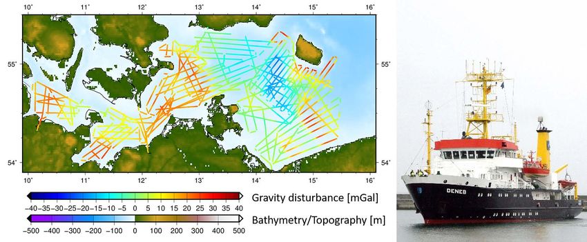
Fachbeitrag Förste et al., Marine Gravimetry Activities on the Baltic Sea …
region is strongly affected by postglacial land uplift, these 2 Measurement system
MSL realizations are different, from country to country,
but sometimes even between map sheets depending on The main device used in GFZ’s marine and airborne
the reference epoch. Updating nautical charts and refer‑ gravimetry activities is a mobile Chekan‑AM gravimeter,
ences for different kind of water level information there‑ manufactured by CSRI Elektropribor (Elektropribor 2020)
fore implied large and steady work in the past (Schwabe which was purchased by GFZ in 2011. The measurement
et al. 2020). Furthermore, these inconsistent MSL-based principle of the Chekan‑AM gravimeter is based on re‑
chart datums complicate the prediction of the instanta‑ cording the angle variations of a double quartz elastic tor‑
neous sea level far off the coast, thus adding an extra sion system that is arranged in a viscous damping liquid.
uncertainty margin to ship navigation. This double sensor system is located inside a temperature
In that view, BSCD2000 signifies a change of paradigm stabilized case and mounted on a gyro stabilization sys‑
in hydrography and ship navigation. The new datum will tem. This platform is kept horizontally using six one-axis
be based on the European Vertical Reference System floating gyros. Additionally, some accelerometers are en‑
(EVRS). This means that the new reference level is a geo‑ closed to provide feedback to the internal system. This
potential surface. In order to be able to accurately refer to particular construction ensures that the sensitive axis is
this surface in GNSS-based navigation and to enable for always held in the vertical direction during the movement
seamless transitions between different areas in the Baltic when sailing or flying. Details of the construction of the
Sea, a high precision geoid model is needed. According Chekan instrument and recommendations by the manu‑
to a decision of the Baltic Sea Hydrographic Commission facturer for the data processing can be found in Krasnov
(BSHC), this new geoid model shall be based on gravimet‑ et al. (2011a and 2011b) as well as in the Chekan‑AM
ric data. Therefore, gravity measurements carried out in Operating Manual. The raw recordings of the Chekan‑AM
different parts of the Baltic Sea were an important work gravimeter sensor unit are integer numbers of pixels de‑
package of the FAMOS project to fill up data gaps, check tected by two light beams on two CCD photodetectors.
old data and finally to contribute to the calculation of a These values represent the relative positions of the two
new improved geoid model for the Baltic Sea by 2023. sensor masses in terms of angles and must be convert‑
GFZ German Research Centre for Geosciences Potsdam ed into acceleration units using transformation para
was member of the FAMOS consortium and contribut‑ meters given by the manufacturer (Krasnov et al. 2011a,
ed with shipborne gravimetry campaigns. This work was Zheleznyak et al. 2010). The transformation parameters
done in co‑operation with Federal Agency for Cartogra‑ are based on the position and the rate of change of the
phy and Geodesy (BKG) and German Federal Maritime position (first derivative) of the proof masses.
and Hydrographic Agency (BSH) as well as with Techni‑ To get the position and velocity information for the
cal University of Darmstadt and further Swedish, Finnish gravity recordings, GFZ operates two Javad GNSS re
and Latvian partners. This paper gives an overview of ceivers together with the Chekan‑AM gravimeter. In
GFZ’s FAMOS marine gravimetry campaigns, which were most of the campaigns, the Chekan‑AM was directly
part of our successful activities in the fields of airborne connected to one of the used GNSS receivers. The Javad
and shipborne activities in general for many years. Fur‑ GNSS antennae were installed on top of the used vessels.
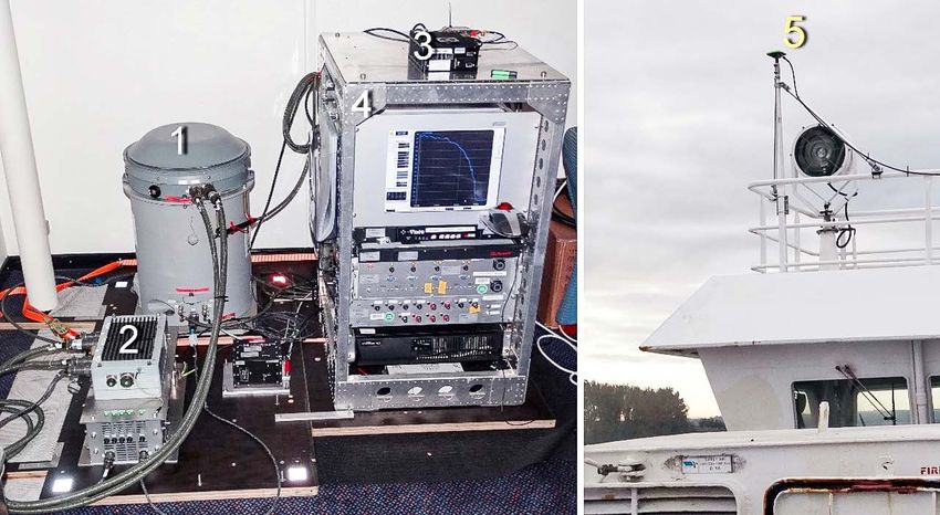
ther corresponding activities for FAMOS were conducted Fig. 1 shows a typical installation of the Chekan‑AM ship
by DTU Space Copenhagen Denmark and the Swedish gravimetry equipment onboard a survey vessel.
National Land Survey (Lantmäteriet LM), but these activ‑ In addition to the Chekan‑AM gravimeter, a strap‑
ities are not subject of this paper. down inertial measurement unit (IMU) of the type
Fig. 1:
Installation of GFZ’s
Chekan‑AM gravimeter
onboard the ferry Stena
Line Urd. The main compo‑
nents are the Chekan sen‑
sor (1), power supply (2),
Javad GNSS receiver (3),
a rack (4) with various
control computers and an
uninterrupted power
supply and one of the
Javad GNSS antennae on
top of the wheelhouse (5).
288 zfv 5/2020 145. Jg. © Wißner-Verlag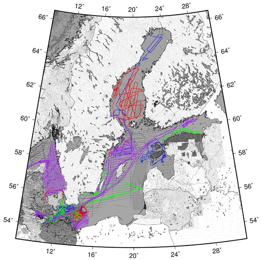
Förste et al., Marine Gravimetry Activities on the Baltic Sea … Fachbeitrag
Fig. 2:
The iNAV-RQH-1003
strapdown gravimeter of
TU Darmstadt (left) and
the thermal stabilization
Source: TU Darmstadt
housing iTempStab-AddOn
used for this strapdown
instrument (right).
iMAR iNAV-RQH-1003 (iMAR Navigation 2012, Fig. 2), within the vessel’s local coordinate system. On the o ther
owned and operated by the Technical University of hand, non-dedicated campaigns mean that the ship
Darmstadt, was installed at two of GFZ’s FAMOS cam‑ in question is sailing for other aims like hydrographic
paigns in 2017 and 2018 on the German survey vessel measurements or for commercial shipping. In such cases,
Deneb (see below). In strapdown gravimetry, an IMU is the installation of the gravimetry equipment may not be
mounted in the vehicle measuring the full acceleration possible at the most suitable place nearby the centers of
vector. Attitude changes are observed using a triad of mass or rotation. Furthermore, a local coordinate system
gyroscopes. Hence, a horizontally stabilized platform is is usually not established on such vessels and additional
not needed. The main advantages of strapdown gravi effort is needed to estimate the eccentricities between the
meters compared to spring-type gravimeters are the lower gravity sensor(s) and the GNSS antennae.
space and power consumption, the lower weight and the For FAMOS, GFZ performed eight ship gravimetry
higher robustness against steering maneuvers and harsh campaigns, twice a year between 2015 and 2018. Four
sea conditions or turbulences. Non-linear accelerometer of these campaigns (one per year) were done onboard
drifts may be problematic, but they can be significant‑ the BSH’s survey vessel Deneb in German waters and ad‑
ly reduced if thermal calibration methods are applied jacent Danish, Swedish and Polish regions, respectively.
(Becker 2016). In most cases, a simple thermal calibration The main purpose of these campaigns was dense gravi‑
of the vertical accelerometer eliminates the bulk of the ty mapping of the German part of the Baltic Sea. These
significant sensor drifts (Becker et al. 2015). Bias stabil‑ campaigns were done jointly by GFZ and BKG. Manage‑
ity can be further improved by encasing the IMU in a ment and track planning for these campaigns were done
thermally stabilized housing like TU Darmstadt’s iMAR by BKG while GFZ operated the Chekan‑AM and GNSS
iTempStab-AddOn (Jensen et al. 2019, Simav et al. 2020), measurements. BKG arranged the local tie measurements
see Fig. 2. on the various harbor piers and the eccentricity estima‑
tion for the GNSS antennae and gravimeter reference
points onboard the ship. The partnership between GFZ
and BKG regards also the data processing for these cam‑
3 FAMOS ship gravimetry measurement paigns. At first, GFZ did the processing of the raw GNSS
campaigns and Chekan‑AM data incl. drift estimation and cross-
over analyses for the individual campaigns. Subsequent‑
The ship gravimetry campaigns done for FAMOS served ly, BKG performed a refined bias and drift adjustment
for two purposes: 1) Mapping gravity in regions without of all campaigns together to generate a harmonized and
already existing gravity data i. e. filling data gaps and evaluated data set of all Deneb gravimetry surveys. The
2) Re‑measuring regions with existing gravity data for latter work is still ongoing and the finalization of the
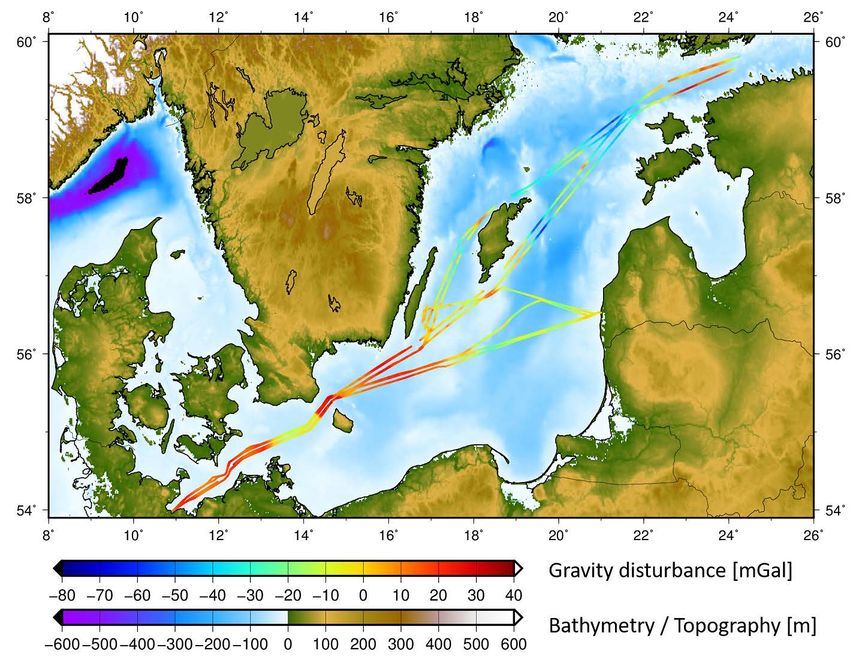
harmonizing and datum correction of old gravity data data set is envisaged by the end of this year. Fig. 3 shows
patches. To fulfill these aims, two kinds of gravimetry the track scheme of the four Deneb campaigns together
campaigns were performed: Dedicated and non-dedicat‑ with the final gravity disturbances measured. The total
ed campaigns. The first kind of campaigns here is sur‑ track length of the Deneb campaigns was about 7300 km.
veys that were done on research vessels, sailing along During the campaigns in 2017 and 2018, the strapdown
particular track plans, which were designed according gravimeter of TU Darmstadt was also installed onboard
to the gravity measurement needs. In such vessels, the side-by-side with GFZ’s Chekan‑AM.
centers of mass and rotation of the ship as well as the Two further dedicated campaigns for FAMOS were
relative positions of the gravimeter (gravity sensor) w. r. t. conducted in 2015 and 2016 mainly on the Bothnian
the GNSS antennae are usually very accurately known Sea and in the Bothnian Bay onboard the Finish vessel
© Wißner-Verlag 145. Jg. 5/2020 zfv 289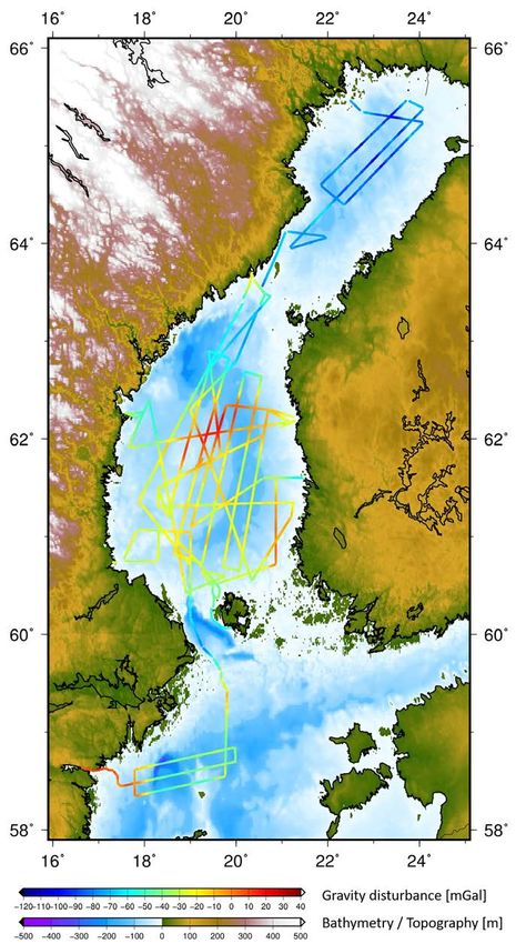
Fachbeitrag                                            Förste et al., Marine Gravimetry Activities on the Baltic Sea …

Fig. 3: The track scheme of the four dedicated campaigns done on BSH’s survey vessel Deneb. The plot shows the
measured gravity disturbance along the tracks together with bathymetry on the sea and topography on land.
A picture of the vessel Deneb is given on the right.

MPV Airisto and the Swedish vessel R/V Jacob Hägg.
Both ships are hydrographic survey vessels. The main
purpose of these campaigns was validation and harmoni‑
zation of old gravity data in these regions. The total track
length of both campaigns together was about 5000 km.
Fig. 4 shows the track scheme of these two campaigns.
Management and track planning were done by GFZ in
close cooperation with Lantmäteriet (LM), Sweden, and
Finish Geospatial Research Institute (FGI). Both institu‑
tions provided the local tie references on the harbor piers.
The data processing (GNSS and Chekan data) was carried
out completely by GFZ. The gravity data collected during
the campaign onboard MPV Airisto have been used in
the meantime for the validation of previous gravity data
and generation of a regional geoid for the Bothnian Sea
(Bilker-Koivula et al. 2017).
   Finally, GFZ performed two non-dedicated campaigns
in 2017 and 2018 onboard the ferry liners M/V Urd (Ste‑
na Line) between Travemünde and Liepaja respectively
onboard M/S Finnlady (Finnlines) between Travemünde
and Helsinki (for details c. f. Ince et al. 2020a and 2020b).
The total track length of both campaigns was about
9700 km. A plot is given in Fig. 5. The main purpose
of these campaigns was collecting records along very
long lines in a cost-efficient way. Such ferry campaigns
with individual track lengths up to 1500 km allow for
a contribution to longer wavelength components of the
Earth’s gravity field as well as again for the validation
and harmonization of existing marine gravity data. Both

Fig. 4: The track scheme of the two dedicated campaigns
onboard the vessels MPV Airisto and R/V Jacob Hägg on
Bothnian Sea and Bothnian Bay

   290    zfv   5/2020 145. Jg.                © Wißner-Verlag
Förste et al., Marine Gravimetry Activities on the Baltic Sea … Fachbeitrag
Fig. 5:
The track scheme of the two
non-dedicated campaigns on‑
board the ferry liners M/V Urd
and M/S Finnlady
campaigns were organized and managed by GFZ, while on sea. Typical filter lengths (i. e. cut-off wavelength)
BKG and FGI provided the local ties in Travemünde and in shipborne gravimetry are about 200 … 400 sec (e. g.
Helsinki, respectively. The local reference gravity value Lu et al. 2019 or Ince et al. 2020a). Usually, the removal
in the harbor of Liepaja was measured by GFZ, supported of very strongly disturbed parts, where filtering does not
by Riga Technical University. work properly, is needed. This is often done by visual
inspection of the results and manual editing of the data.
For the positioning of the gravity records, an estima‑
tion of the trajectory of the vessel respectively the grav‑
4 Aspects of data processing ity sensor is needed. For this purpose, GNSS data are
simultaneously recorded together with the gravity data.
The data processing in ship gravimetry from the raw It is common practice to install more than one GNSS
data to the final gravity product comprises a sequence receiver resp. antenna onboard. This gives among others
of dedicated and sophisticated working steps. Many of the option to compute GNSS-based orientations of the
these working steps are hardly done automatically by particular vessel.
software tools alone. First of all, the raw gravity records Last but not least, after filtering and trajectory estima‑
are heavily contaminated by noise caused by disturbing tion, the reduction of the centrifugal and Coriolis accel‑
kinematic movements of the ship like rolling and pitch‑ erations caused by the vessel’s movement on the curved
ing. Further disturbances may be caused e. g. by noise of surface of the rotating Earth (Eötvös correction) has to
the engine. And in case of classical spring gravimeters be done.
like our Chekan‑AM, abrupt speed variations and strong Classical spring gravimeters as well as novel strap‑
deviations from straight-ahead-movement like turnings down instruments are relative measurement instruments
may generate additional disturbances. featuring a drift. Drift and bias estimation are usually
The disturbing noise in the gravimetric recordings is performed on the basis of local ties in the harbors. This
usually some orders of magnitude larger than the gravity means, ship gravimetry includes measurement of gravi‑
signal. But fortunately, in the case of marine gravimetry ty ties at the harbor piers to absolute gravity points. In
this noise affects mainly just the higher frequencies and cases where the height of the gravimeter sensor above
can be removed by low pass filtering. Therefore, in con‑ the pier is larger than a couple of meters an estimation of
trast to airborne gravimetry, estimation of the velocity the local gravity gradients at the harbor pier is advisable
including vertical disturbing kinematic acceleration is to link the absolute gravity reference value to the in‑
usually not needed in shipborne gravimetry. The opti‑ strumental sensor height onboard as accurate as possible
mum filter lengths for the lowpass filter depend on the (Ince et al. 2020a).
particular measurement conditions like speed and size of At the end, careful validation of the obtained results
the vessel as well as on the particular weather conditions is recommended. This includes comparisons resp. con‑
© Wißner-Verlag 145. Jg. 5/2020 zfv 291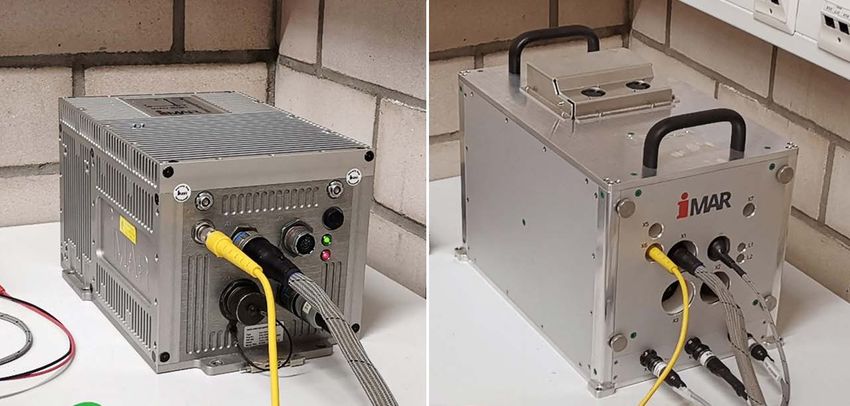
Fachbeitrag                                             Förste et al., Marine Gravimetry Activities on the Baltic Sea …

sistency checks to external data like global gravity field            In several marine and airborne campaigns (FAMOS
models, bathymetry data and already existing gravity               Deneb 2017, among others), both strapdown processing
data on the sea. The main and commonly applied ap‑                 methods have been tested, resulting in similar accuracies
proach to validate drift and bias estimation of shipborne          (Johann et al. 2020). The FAMOS Deneb 2018 campaign
gravimetry data is performing cross-over point analyses,           was processed applying the direct method. Detailed in‑
which gives a reliable measure of the achieved accura‑             sights in the processing strategies of the indirect and the
cy for the particular gravimetry survey. For the Chekan            direct method can be found in Becker (2016) and Johann
based marine gravity data, the accuracy obtained from              et al. (2019). For the Deneb campaigns, the kinematic ac‑
cross-over point residuals is usually below 1 mGal, pri‑           celeration was neglected.
marily depending on the sea condition (Krasnov et al.                 Since the strapdown IMU and the Chekan‑AM ran
2014, Lu et al. 2019, Ince et al. 2020a).                          side-by-side in the FAMOS campaigns onboard the vessel
   Detailed explanation of our ship gravimetry data pro‑           Deneb in 2017 and 2018, their results can be compared
cessing is not the aim of this paper and for interested            directly, e. g. based on the RMSE (RMS divided by the
readers we refer to other recent publications from our side        square root of 2) of the cross-over point gravity residuals.
like Lu et al. (2019) and Ince et al. (2020a). Here we focus       Regarding approximately straight track segments with‑
on one particular data processing aspect only, a com‑              out harsh sea conditions in 2017, RMSE of 0.33 mGal
parison between GFZ’s Chekan‑AM and TU Darmstadt’s                 and 0.7 mGal were obtained with the Chekan‑AM and
strapdown measurements, which is outlined in the fol‑              the strapdown IMU, respectively. Encasing the strapdown
lowing chapter.                                                    IMU in the thermally stabilized housing in 2018, the
                                                                   cruise-wise adjusted RMSE improved to about 0.41 mGal
                                                                   (0.52 mGal before adjustment), which indicates a preci‑
                                                                   sion similar to the Chekan‑AM (0.39 mGal). More details
5 Comparison between Chekan-AM and                                 are given in Johann et al. (2020).
  strapdown measurements                                              Fig. 6 shows strengths and weaknesses of both meas‑
                                                                   urement systems for the example of the gravity distur‑
In strapdown airborne and marine gravimetry two basic              bance results obtained from the last cruise of the FAMOS
processing approaches can be distinguished: the direct             Deneb 2018 campaign. On the one hand, the Chekan data
and the indirect method (Jekeli and Garcia 1997, Jeke‑             contain clearly visible erroneous spikes. They usually
li 2001). Using the indirect method, all IMU and GNSS              arise during turning maneuvers. Moreover, the Chekan
observations are integrated in a single Extended Kalman            results are impaired during periods of harsh sea con‑
Filter. Gravity is obtained indirectly from the position           ditions. Note that these periods are usually cropped in
domain. Alternatively, gravity can be computed directly            post-processing. In contrast, removing such periods is
in the acceleration domain: In the direct method, gravi‑           not necessary in marine strapdown gravimetry since the
ty is obtained by taking the difference of the kinematic           impact of non-uniform vehicle motion is much smaller
accelerations and the accelerometer measurements, the              here. On the other hand, the remaining long-wavelength
so‑called specific force, considering the Eötvös cor‑              differences between the results of both instruments are
rection. However, a GNSS/IMU integration is still nec‑             expected to be primarily caused by non-linear IMU drifts
essary to account for the IMU’s changing 3‑D attitude              – a challenge in strapdown gravimetry, especially at the
vector. The kinematic acceleration is obtained by nu‑              multi-day cruises of the Deneb campaigns. Therefore, a
merically differentiating twice the GNSS position solu-            combination of both measurement systems might enable
tion, which can be determined by Precise Point Position‑           enhanced results with complete and reliable short-wave‑
ing (PPP).                                                         length results and also a high long-wavelength stability.

Fig. 6: Comparison of estimated vertical gravity disturbances at the last cruise of Deneb 2018 (blue: strapdown;
green: Chekan-AM)

   292   zfv   5/2020 145. Jg.                 © Wißner-Verlag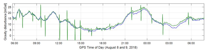
Förste et al., Marine Gravimetry Activities on the Baltic Sea … Fachbeitrag
6 Results and outlook sea was frozen, especially on the Gulf of Bothnia (Noréus
et al. 1997). The largest remaining data gaps are in the
The described shipborne activities of GFZ and BKG to‑ eastern part of the Gulf of Finland and in waters North
gether with TU Darmstadt are an important contribution of Poland. At least for the latter region there exists a
to the generation of the new Baltic Sea Chart Datum. The good chance to close the gap since institutions from Po‑
measured gravity data are collected at the FAMOS data land (University of Gdansk in cooperation with the Polish
base managed by DTU Space Copenhagen, Denmark. In Navy) cooperate with the CDWG and have started marine
addition, the final processed data set of the two ferry gravimetry surveys in the meantime. A further aspect is
campaigns (Urd 2017 and Finnlady 2018) is freely avail‑ the generation of the new geoid for the Baltics which
able for download from GFZ Data Services (Ince et al. should be a combined geoid model comprising contri‑
2020b). butions from those of the FAMOS cooperation partners
Fig. 7:
Map of the currently available
gravity data in the FAMOS data
base. The purple, red, blue and
green lines are the tracks of the
ship- and airborne gravimetry sur‑
veys in the framework of FAMOS
done since 2015. The grey lines
and dots in the sea areas are
gravimetry data from previous
decades (by courtesy of Jonas
Ågren, Lantmäteriet).
The work on the new Baltic Sea Chart Datum is not yet working in the field of regional gravity field modelling.
finished. Since the support by EU for the FAMOS project Finally, it is planned to implement the new BSCD2000
ended mid of last year, the work cannot be continued by 2023.
in the context of this project. Therefore, to finalize the Apart from FAMOS, the cooperation partners GFZ,
generation of the new height reference for the Baltic Sea, BKG and TU Darmstadt will continue their successful
the Chart Datum Working Group (CDWG) within the Bal‑ cooperation. For instance, shipborne gravimetry on the
tic Sea Hydrographic Commission (BSHC) has agreed to North Sea is planned for 2021 again on the vessel Deneb.
take over the coordination for the production of the final This campaign will be a continuation of a survey in the
BSCD2000. This comprises several tasks. At first, still ex‑ German Wadden Sea done in 2015. The purpose of these
isting significant data gaps should be closed if possible. campaigns in the North Sea is the improvement of the
Fig. 7 shows a map of the currently available gravity data marine geoid there.
in the FAMOS data base. This data collection comprises
gravity data recordings within the FAMOS project as well
as gravity data from decades back to 1956. It is worth Acknowledgements
noting that these old data sets comprise previous ship- The described marine gravimetry campaigns were per‑
and airborne data but also field gravimeter measure‑ formed within the project “Finalizing Surveys for the Bal‑
ments on the ice surface taken in cold winters when the tic Motorways of the Sea” (FAMOS) that was supported
© Wißner-Verlag 145. Jg. 5/2020 zfv 293Fachbeitrag Förste et al., Marine Gravimetry Activities on the Baltic Sea …
by the European Commission within the Connecting Eu‑ Johann, F., Becker, D., Becker, M., Forsberg, R., Kadir, M. (2019): The
rope Facility (CEF) Transport Sector under the Grants No. Direct Method in Strapdown Airborne Gravimetry – a Review. In:
zfv – Zeitschrift für Geodäsie, Geoinformation und Landmanage‑
INEA/CEF/TRAN/M2014/1027106 and INEA/CEF/TRAN/ ment 144, 323–333. DOI: 10.12902/zfv-0263-2019.
M2015/1124688. Specifically, GFZ’s and BKG’s FAMOS Johann, F., Becker, D., Becker, M., Ince, E. S. (2020): Multi-Scenario
activities were financially supported for 50 % from the Evaluation of the Direct Method in Strapdown Airborne and Ship‑
FAMOS project. The implementation of the individual borne Gravimetry. In: Proceedings of the 5th IAG Symposium on
Terrestrial Gravimetry: Static and Mobile Measurements. Interna‑
campaigns was enabled by support of German Federal tional Association of Geodesy Symposia, Springer, [in review].
Maritime and Hydrographic Agency (BSH), Finish Trans‑ Krasnov, A. A., Nesenyuk, L. P., Peshekhonov, V. G., Sokolov, A. V., Elin‑
port Agency (FTA), Swedish Maritime Administration son, L. S. (2011a). Integrated marine gravimetric system. Develop‑
(SMA) and Maritime Administration of Latvia (MAL). We ment and operation results. In: Gyroscopy and Navigation 2 (2),
75–81. DOI: 10.1134/S2075108711020052.
are also thankful for several kinds of support by colleagues Krasnov, A. A., Sokolov, A. V., Usov, S. V. (2011b): Modern equip‑
of Swedish National Land Survey (Lantmäteriet LM), DTU ment and methods for gravity investigation in hard-to-reach re‑
Space Copenhagen Denmark, Finish Geospatial Research gions. In: Gyroscopy and Navigation 2 (3), 178–183. DOI: 10.1134/
Institute (FGI) and Riga Technical University Latvia. The S2075108711030072.
Krasnov, A. A., Sokolov, A. V., Elinson, L. S. (2014): Operational experi‑
shipping companies Stena Line Scandinavia AB Göte‑ ence with the Chekan-AM gravimeters. In: Gyroscopy and Naviga‑
borg, Finnlines Oyj Helsinki and Meritaito Oy Helsinki tion 5 (3), 181–185. DOI: 10.1134/S2075108714030079.
are acknowledged for supporting the two ferry campaigns Lu, B., Barthelmes, F., Li, M., Förste, C., Ince, E. S., Petrovic, S., Flecht
and the campaign on the survey vessel MPV Airisto. ner, F., Schwabe, J., Luo, Z., Zhong, B., He, K. (2019): Shipborne
gravimetry in the Baltic Sea: Data processing strategies, crucial
findings and preliminary geoid determination tests. In: Journal of
Geodesy, 93 (7), 1059–1071. DOI: 10.1007/s00190-018-01225-7.
References Nordic Geodetic Commission (NKG) (2020): www.nordicgeodeticcom
Ågren, J., Liebsch, G., Mononen, J. (2019): Specification of the Bal‑ mission.com/geoid-and-height-systems, last access 06/2020.
tic Sea Chart Datum 2000 (BSCD2000). www.bshc.pro/media/ Noréus J. P., Nyborg, M. R., Hayling, K. L. (1997): The gravity anomaly
documents/CDWG/CDWG+Specification+of+the+Baltic+Sea+Chart field in the Gulf of Bothnia spatially characterized from satellite
+Datum+2000.pdf, last access 04/2020. altimetry and in situ measurements. In: Journal of Applied Geo‑
Becker, D. (2016): Advanced Calibration Methods for Strapdown Air‑ physics 37, 67–84. DOI: 10.1016/S0926-9851(97)00007-4.
borne Gravimetry. In: Schriftenreihe der Fachrichtung Geodäsie, Schwabe, J., Ågren, J., Liebsch, G., Westfeld, P., Hammarklint, T., Mo
Technische Universität Darmstadt, ISBN 978-3-935631-40-2. http:// nonen, J., Andersen, O. B. (2020): The Baltic Sea Chart Datum 2000
tuprints.ulb.tu-darmstadt.de/5691/, last access 06/2020. (BSCD2000) – Implementation of a common reference level in the
Becker, D., Nielsen, J. E., Ayres-Sampaio, D., Forsberg, R., Becker, M., Baltic Sea. In: International Hydrographic Review, No. 23 (May
Bastos, L. (2015): Drift reduction in strapdown airborne gravime‑ 2020), 63–83. https://iho.int/uploads/user/pubs/ihreview_P1/IHR_
try using a simple thermal correction. In: Journal of Geodesy 89, May2020.pdf, last access 2020-07-14.
1133–1144. DOI: 10.1007/s00190-015-0839-8. Simav, M., Becker, D., Yildiz, H., Hoss, M. (2020): Impact of temperature
Bilker-Koivula, M., Mononen, J., Saari, T., Förste, C., Barthelmes, F., Lu, stabilization on the strapdown airborne gravimetry: a case study in
B., Ågren, J. (2017): Improving the geoid model for future GNSS- Central Turkey. In: Journal of Geodesy 94 (4). DOI: 10.1007/s00190-
based navigation in the Baltic Sea. In: Proceedings, FIG Working 020-01369-5.
Week “Surveying the world of tomorrow – From digitalisation to STM (2020): MONALISA – Motorways & Electronic Navigation by Intel‑
augmented reality” (Helsinki 2017). www.fig.net/resources/procee ligence on Sea. www.seatrafficmanagement.info/projects/monalisa,
dings/fig_proceedings/fig2017/papers/iss6b/ISS6B_bilker-koivula_ last access 06/2020 and www.seatrafficmanagement.info/projects/
mononen_et_al_8935.pdf, last access 06/2020. monalisa-2, last access 06/2020.
Elektropribor (2020): State Research center of the Russian Federation Zheleznyak, L. K., Krasnov, A. A., Sokolov, A. V. (2010): Effect of the in‑
Concern CSRI Elektropribor. JSC. www.elektropribor.spb.ru/en, last ertial accelerations on the accuracy of the CHEKAN-AM gravimeter.
access 06/2020. In: Izvestiya, Physics of the Solid Earth 46 (7), 580–3. DOI: 10.1134/
FAMOS consortium (2014–2020): Finalising Surveys for the Baltic Mo‑ S1069351310070025.
torways of the Sea – FAMOS. Retrieved from www.famosproject.eu,
last access 06/2020.
IMAR Navigation (2012): iNAV-RQH-1003: Inertial Measurement Sys‑ Contact
tem for Advanced Applications. St. Ingbert. www.imar-navigation. Christoph Förste | E. Sinem Ince
de/downloads/NAV_RQH_1003_en.pdf, last access 06/2020. Helmholtz Centre Potsdam GFZ
Ince, E. S., Förste, C., Barthelmes, F., Pflug H., Li, M., Kaminskis, J., Neu‑ German Research Centre for Geosciences
mayer, K.-H., Michalak, G. (2020a): Gravity Measurements along Telegrafenberg, 14473 Potsdam, Germany
Commercial Ferry Lines in the Baltic Sea and their Use for Geodetic foer@gfz-potsdam.de | sinem@gfz-potsdam.de
Purposes. In: Marine Geodesy. DOI: 10.1080/01490419.2020.1771486.
Ince, E. S., Förste, C., Barthelmes, F., Hartmut, H. (2020b): Ferry Gravi Felix Johann
metry Data from the EU FAMOS project. GFZ Data Services. DOI: Technical University of Darmstadt
10.5880/GFZ.1.2.2020.001. Institute of Geodesy
Jekeli, C. (2001): Inertial Navigation Systems with Geodetic Applica‑ Franziska-Braun-Straße 7, 64287 Darmstadt, Germany
tions Inertial Navigation Systems with Geodetic Applications. de johann@psg.tu-darmstadt.de
Gruyter, Berlin. DOI: 10.1515/9783110800234.
Jekeli, C., Garcia, R. (1997): GPS phase accelerations for moving-base Joachim Schwabe | Gunter Liebsch
vector gravimetry. In: Journal of Geodesy 71, 630–639. DOI: Federal Agency for Cartography and Geodesy
10.1007/s001900050130. – Branch Office Leipzig –
Jensen, T. E., Olesen, A. V., Forsberg, R., Olsson, P. A., Josefsson, Ö. Karl-Rothe-Straße 10-14, 04105 Leipzig, Germany
(2019): New results from strapdown airborne gravimetry using tem‑ joachim.schwabe@bkg.bund.de | gunter.liebsch@bkg.bund.de
perature stabilisation. In: Remote Sensing, 2019, 11(22), 2682. DOI:
10.3390/rs11222682. This article also is digitally available under www.geodaesie.info.
294 zfv 5/2020 145. Jg. © Wißner-VerlagYou can also read