Marsupial Walking-and-Flying Robotic Deployment for Collaborative Exploration of Unknown Environments
←
→
Page content transcription
If your browser does not render page correctly, please read the page content below
Marsupial Walking-and-Flying Robotic Deployment for Collaborative
                                                        Exploration of Unknown Environments
                                                  Paolo De Petris1,? , Shehryar Khattak2,? , Mihir Dharmadhikari1 , Gabriel Waibel2 , Huan Nguyen1
                                                         Markus Montenegro2 , Nikhil Khedekar1 , Kostas Alexis1 , and Marco Hutter2

                                             Abstract— This work contributes a marsupial robotic system-       hinder its utility. Yet, that could be where the legged robot
                                         of-systems involving a legged and an aerial robot capable             mostly benefits from its supporting skills. Motivated by
                                         of collaborative mapping and exploration path planning that           the above, in this work we develop and demonstrate the
arXiv:2205.05477v1 [cs.RO] 11 May 2022

                                         exploits the heterogeneous properties of the two systems and the
                                         ability to selectively deploy the aerial system from the ground       marsupial combination of a ground and a flying robot within a
                                         robot. Exploiting the dexterous locomotion capabilities and long      system-of-systems approach, shown in Figure 1, being capable
                                         endurance of quadruped robots, the marsupial combination              of performing autonomous exploration and collaborative
                                         can explore within large-scale and confined environments in-          mapping. Thus leveraging the long endurance and dexterous
                                         volving rough terrain. However, as certain types of terrain           locomotion of legged systems, and self-deploying an agile
                                         or vertical geometries can render any ground system unable
                                         to continue its exploration, the marsupial system can –when           aerial robot when needed and where it truly matters.
                                         needed– deploy the flying robot which, by exploiting its 3D
                                         navigation capabilities, can undertake a focused exploration
                                         task within its endurance limitations. Focusing on autonomy,
                                         the two systems can co-localize and map together by sharing
                                         LiDAR-based maps and plan exploration paths individually,
                                         while a tailored graph search onboard the legged robot allows
                                         it to identify where and when the ferried aerial platform should
                                         be deployed. The system is verified within multiple experimental
                                         studies demonstrating the expanded exploration capabilities of
                                         the marsupial system-of-systems and facilitating the exploration
                                         of otherwise individually unreachable areas.

                                                                I. I NTRODUCTION
                                            Robotic systems have proven their value in exploration
                                         and inspection tasks across a variety of environments [1]–[6].
                                         Legged and flying robots, in particular, have demonstrated
                                         their advanced potential in this domain. Legged systems
                                         present dexterous locomotion capabilities thus allowing to
                                         overcome challenging terrain, negotiating narrow-access pas-          Fig. 1. Instance of the developed marsupial integrated legged-and-aerial
                                         sages, and enabling the traversal of multi-storey facilities [3,7],   robotic system-of-systems tailored for the large-scale autonomous exploration
                                         while maintaining operational endurance for long periods.             and mapping applications.
                                         However, being a ground platform, they cannot traverse all
                                         types of terrain, overcome all types of geometric structures,            The particular design was motivated by the needs of the
                                         pass through windows, or acquire a bird’s eye views. On               DARPA Subterranean Challenge but its potential extends
                                         the other hand, aerial systems are unbounded from terrain             across inspection applications. In this context, the ANYmal
                                         limitations and can seamlessly navigate in 3D, yet their              legged robot [8] is considered as the main unit performing
                                         limited endurance prevents them from undertaking large-               autonomous localization and mapping, as well as exploration
                                         scale tasks in a single deployment. Multi-robot teaming,              path planning thus unveiling most of the map but, naturally,
                                         especially by exploiting the heterogeneity of ground and              it can face traversability limitations and inability to assume
                                         aerial platforms, provides an avenue to benefit from the              viewpoints at heights. Accordingly, when the geometry
                                         complementary advantages of both and overcome their                   of the environment necessitates, ANYmal can deploy the
                                         individual limitations. However, if deployed separately their         RMF-Owl aerial robot [9] which it ferries onboard. At
                                         platform-specific disadvantages may remain pertinent. An              start-up, RMF-Owl acquires the most current LiDAR-based
                                         aerial robot may be most useful in an area far from the               map of the environment as reconstructed by ANYmal in
                                         deployment point which means that its endurance constraints           which it co-localizes to obtain its initial pose estimate in
                                                                                                               consistent coordinates. Subsequently, the aerial robot performs
                                                                                                               autonomous exploration targeted towards an area of interest
                                           ?  The authors have contributed equally.
                                           1 NTNU,                                                             thus complementing the ground system to which it shares
                                                     O. S. Bragstads Plass 2D, 7034, Trondheim, Norway
                                           2 ETH Zurich, Leonhardstrasse 21, 8092, Zurich, Switzerland         the map built online before returning back to the home
                                           Correspondence email: paolo.de.petris@ntnu.no                       location. ANYmal can then, in parallel or sequentially,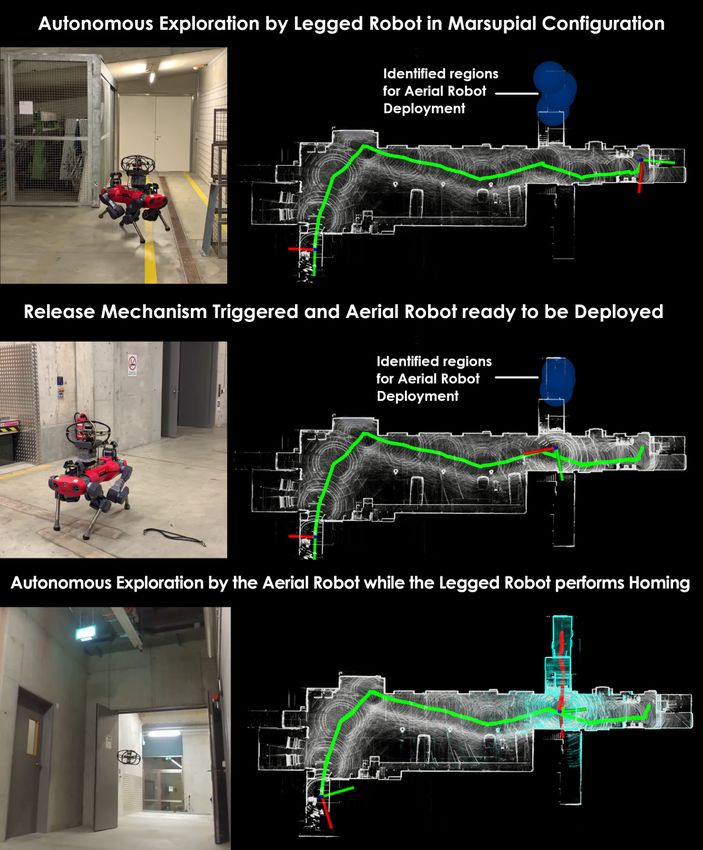
continue its exploration mission. The marsupial combination
is thus presenting complementary navigation capabilities and
a collective capacity to explore more space, and reach further
than the two systems individually or potentially compared
to their co-deployment from the same starting point. To
demonstrate the value of the proposed system-of-systems
we present a set of experiments where complete exploration
is not possible by the ground robot alone, or where the
combination allows for faster overall coverage.
                    II. R ELATED W ORK
   Marsupial-based robotic systems have been demonstrated
to increase the overall capability of the system by exploiting
the complementary strength of each robot [10]. The work
in [11] presents the use of a marsupial system consisting of
an unmanned surface vehicle (USV) and an unmanned aerial
vehicle (UAV) in the inspecting of freshwater ecosystems,
combining the advantages of the long operation time of the
USV and the increased field of view provided by the UAV.
Additionally, marsupial systems with aerial and ground robots
are utilized in the context of planetary exploration [12] and     Fig. 2. Proposed marsupial ground-and-aerial carriage mechanism. Details
disaster response tasks [13]. Other works in the domain of        of the elastic band left side 1) and right side 2) attachment. When the
marsupial robotic systems’ deployment aim to determine the        electropermanent magnet is charged 2a), RMF-Owl is firmly secured on
                                                                  the foam base while ANYmal-C continues its exploration path. When the
deployment and possible retrieval time for the marsupial          time of deployment is reached the EPM is discharged 2b) and the designed
system. The work in [14] considers the problem of deploying       mechanism safely releases the elastic band 2c), 2d).
two flying robots from an unmanned ground vehicle and
solves an optimization problem to minimize the time for           A. System Overview
reaching multiple target points. A different objective is
proposed in [15], where a marsupial system consisting of two         For real-world experiments, the presented approach utilizes
aircrafts is tasked to gather information about an object of      a ground-based legged robot, ANYmal-C [8], and an aerial
interest, while minimizing the likelihood of their detection by   robot, RMF-Owl [9], in a marsupial system-of-systems
their opponent. In the context of autonomous exploration, the     manner, as shown in Figure 1. The ANYmal robot has a
authors in [16] propose a Monte Carlo tree search method          payload capacity of 10 kg and a continuous operation time
using the solution to the sequential stochastic assignment        of 1 hour. For locomotion, the controller proposed by [7]
problem as a roll out action-selection policy to address          was utilized and ANYmal-C walked with a nominal speed of
the problem of planning deployment times and locations            0.7 m s−1 during the experiments. For localization, mapping
of the carrier robots. The method is verified offline using       and path-planning, ANYmal-C utilized measurements from an
the recorded data from the Urban Circuit of the DARPA             on-board Velodyne VLP-16 LiDAR, an Epson M-G365PDF0
Subterranean Challenge [17] to select the locations to deploy     IMU and kinematic odometry estimates [20]. The VLP-16
the passenger aerial robots and to explore the frontiers that     sensor offers a Field of View (FOV) of [360, 30]◦ and a
cannot be accessed by the ground robots. Another work             maximum range of 100m. The RMF-Owl, is a lightweight
in [18] presents a hierarchical approach where a high-level       collision-tolerant aerial robot with a custom designed chassis
planner generates a topological multi-graph, encoding the         and weighing 1.4 kg. This robot has an operation time of
locomotion capabilities of each robot and multiple low-level      12 minutes and during experiments operated with a nominal
planners create optimal trajectories considering each robot’s     speed of 1.0 m s−1 . For all autonomous operations, RMF-Owl
dynamics and constraints. In [19], the problem of multi-          utilized an Ouster OS0-64 LiDAR with inertial measurements
robot exploration with marsupial robots is cast as a temporal     provided by the flight controller IMU. The OS0-64 offers
planning problem which is solved by integrating a temporal        FOV equal to [360, 90]◦ and a max range of 50m. The aerial
symbolic planner that plans the deployment and the retrieval      robot is carried on top on the legged robot using a custom
actions combined with a traditional path planner.                 design mechanism employing a flexible elastic strap to keep
                                                                  the aerial robot secure during the walking of the legged
        III. M ARSUPIAL ROBOTIC E XPLORATION                      robot. As depicted in Figure 2, the carriage mechanism is
   The proposed solution of marsupial robotic system-of-          equipped with an electropermanent magnet (EPM) permitting
systems exploration and mapping relies on the synergy of          the aerial robot to be released when commanded by the
legged and aerial robots that can share maps bidirectionally,     planning framework of the legged robot. The proposed design
co-localize and perform synergistic exploration exploiting        utilizes the tension in the elastic strap to displace it away
their complementary capabilities.                                 from the aerial robot upon release to ensure safety during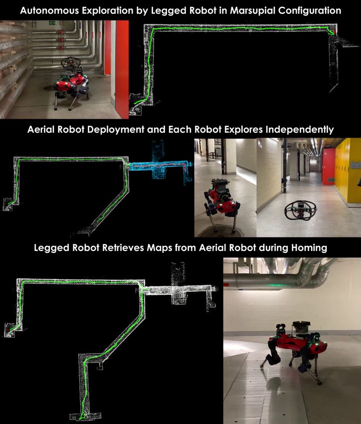
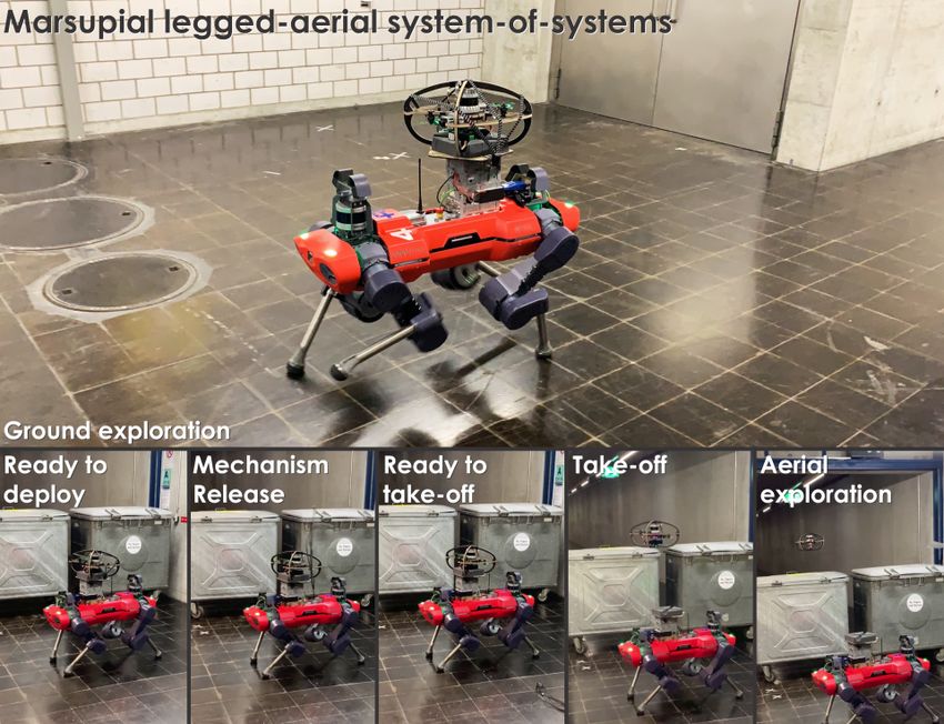
Fig. 3. Concept visualization of the proposed marsupial ground-and-aerial robotic exploration solution and its key phases. The legged robot initiates
exploration, while ferrying the flying system onboard. While individually exploring the environment, it also maintains a sparse graph the vertices of which
consider the volumetric gain based on the aerial robot’s depth sensor and identifies points where the deployment of the the flying system is beneficial. The
legged robot then at a certain point deploys the flying robot. Right before take-off, the two systems share the legged robot’s map on which the aerial robot
co-localizes and then initiates its individual autonomous exploration focused by the map knowledge of the ground system. Both robots continue exploration
individually, share maps also bidirectionally and return to the home location (or other defined setpoint) prior to the depletion of their endurance capabilities.

take-off without the need for any additional moving parts and                     blocks with corresponding hash indices. To co-localize robots
also maintaining a light-weight reusable design. Both robots                      in the unified map, especially during the deployment of the
maintain communication with each other and the base-station                       aerial robot from the legged system, the pose of the legged
using the NimbRo framework [21]. All map-sharing, co-                             robot in the unified map is also shared with the aerial robot.
localization and marsupial exploration planning components                        The shared pose is transformed with respect to the extrinsic
were deployed fully on-board each robot and executed in                           mounting orientation of the LiDARs on the legged and aerial
real-time during all missions.                                                    robots, and is then used as an initialization guess for the for
                                                                                  current pose estimation of the aerial robot in the unified map.
B. Heterogeneous Robot Map Sharing and Co-localization                            The co-localization process utilizes this initialization guess to
   To enable collaborative autonomous operation among                             register the current robot scan with the updated unified map by
heterogeneous legged-and-aerial platforms in a marsupial                          minimizing point-to-line and point-to-plane correspondences
configuration, a bi-directional map sharing and co-localization                   in an iterative manner. Success of the co-localization process
technique was developed. The proposed method extends                              is determined by monitoring the incremental pose updates and
our complementary multi-modal localization and mapping                            the remaining number of allowed iterations. If the incremental
framework, CompSLAM [22], specifically enabling LiDAR                             pose updates become smaller than a pre-defined threshold
map sharing and co-localization. The key idea behind this                         with the maximum number of allowed iterations not reached,
extension is that both robots operate in a unified map in a                       the robot is determined to be co-localized successfully and a
consistent coordinate system, initialized at the deployment                       success indicator is returned to the state-machine otherwise,
position of the legged robot, while maintaining the flexibility                   in case of non-convergence failure, a warning is raised and
for each robot to update parts of the unified map independently                   the co-localization process has to be restarted.
during a joint autonomous exploration phase. To facilitate
map sharing, similar to map maintenance proposed in [23],                         C. Marsupial Exploration Path Planning
the unified map is divided into blocks of volume 10m3 , with                         To enable the autonomous exploration path planning by
each block identified by a unique hash calculated by the                          the marsupial legged-and-aerial robotic system-of-systems,
location of each block’s center with respect to the origin.                       a specialized path planning solution was developed. The
Furthermore, each map block is sub-divided into feature sub-                      method extends our open-sourced Graph-based exploration
blocks containing edge and planar points. During operation,                       path planner (GBPlanner) [24] which guided all legged
both robots maintain and populate a copy of the unified                           and flying robots of Team CERBERUS in the DARPA
map onboard, while sharing the same block hash indices                            Subterranean Challenge. GBPlanner allowed the efficient
among them. Upon request, the map blocks are shared with                          exploration of complex subterranean environments despite
other robot, updating its on-board map by appending the map                       the large-scale, at places highly confined and obstacle-filled,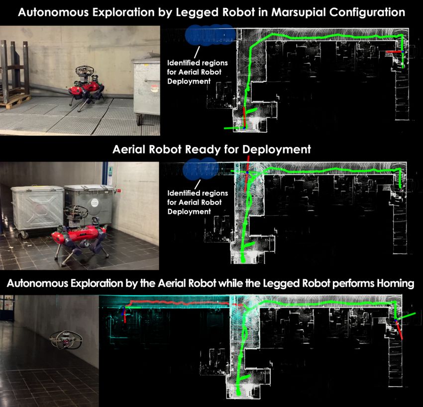
multi-level geometries often involved. The method utilizes             the flying system utilizes the local stage to plan efficiently
a volumetric representation of the environment [25] and                around the robot by adjusting the gain of the vertices in its
employs a bifurcated architecture involving a local and a              graph structure GA                             A
                                                                                          l , while its global graph Gg is exploited
global planning stage. At the local step, the planner spans at         for frontier re-positioning and auto-homing.
every iteration a dense random graph Gl within a spatially-
defined bounding box and identifies paths that maximize                                  IV. E XPERIMENTAL R ESULTS
an exploration gain representing primarily the amount of                 To systematically evaluate the real-world application and
unknown volume to be mapped. However, as geometries                    performance of the proposed marsupial system-of-systems
can locally be fully mapped (e.g., a dead-end of a mine                approach, experimental tests were conducted in three different
drift) or because a certain type of robot may be unable                environments. The deployment environments emulated real-
to explore all of the local area (e.g., a ground robot will            world challenges such as, exploration of areas unreachable
be unable to fly up to a different level through a stope or            by the ground robot, access to blocked sections of the
overcome a tall obstacle), the local stage will –at instances–         environment and joint exploration of complex environments
report “completion”. GBPlanner then invokes its global stage           with branching paths.
which exploits an incrementally built sparse global graph Gg
assembled by selective subsets of the local graphs {Gl }. In
this sparse global graph, the method can efficiently identify
prioritized frontiers, derive optimized paths to such frontiers,
and enable auto-homing functionality. GBPlanner is used
“as is” to guide the ground robot in its exploration mission
and to perform auto-homing given the robot’s VLP-16 range
sensor and its FOV [FH     G
                             , FVG ] = [360, 30]◦ and a reduced
considered maximum range of dG       max = 20m, while respecting
the traversability limitations of the platform. The two, local
and global, graph data structures GG           G
                                          l , Gg are maintained
onboard the ground robot.
   The method is however extended in order to guide the
marsupial legged-and-aerial robot combination in a manner
that exploits their synergies. More specifically, the planner
on the ground robot also builds a new sparse global random
graph GG→Am      with vertices spanning over the explored 3D
space. This new graph is distinct than the global graph
of GBPlanner responsible for frontier re-positioning and
                                  i
auto-homing. Every vertex vm          of GG→A
                                           m      is evaluated for
exploration gain –being the new previously unmaped volume
    i
V(vm   )– observed by that vertex given the aerial robot’s depth
sensor with FOV [FH     A
                          , FVA ]◦ = [360, 90]◦ and considered
                   A                            i
effective range dmax = 20m. The vertices vm         that are farther
than a distance rm from the current robot location and outside
a radius rg of the frontiers in the ground robot’s global graph
GG                                      j
  g are clustered and their centers om are marked as possible
                                                                       Fig. 4. Autonomous exploration of an underground garage using hetero-
regions where the aerial robot can be deployed.                        geneous robot system-of-systems. Top row shows ANYmal and RMF-Owl
   When GBPlanner on the ground robot reports local                    starting the mission in marsupial configuration and the identification of the
completion, the system checks if it has found any areas                potential regions for the aerial robot deployment. The middle row shows the
                                                                       triggering of the release mechanism at one of the aerial robot deployment
(and associated points ojm ) where the aerial robot can be             location. The bottom row shows both the maps and the exploration paths
deployed. If yes, it moves to the closest region by querying           of ANYmal (Green) and RMF-Owl (Red) in different sections of the
paths to the vertices in GG  g closest to these regions, and the
                                                                       environment. The final onboard map of ANYmal contains the region explored
                                                                       by RMF-Owl.
associated ojm , and taking the shortest path among those. Once
reached, the ground robot then shares this graph GG→A    m     with
the aerial robot along with a general exploration bounding             A. Complementary Exploration of Inaccessible Areas
box that starts from the current robot height coordinate and              To demonstrate the benefit of utilizing a system-of-systems
expands upwards (or downwards). The GBPlanner on the                   approach for autonomous exploration, experiments were
aerial robot operates similarly to the original method, however        conducted in environments with some sections accessible
every vertex that reaches higher (or lower) in altitude has an         to one type of robot but not the other. The complete
increased gain with the goal to promote vertical exploration,          exploration of these environments required the utilization of
while every vertex that spans within the areas spanned in              the complementary navigation capabilities of legged and aerial
GG→A
  m      has a decreased gain. Accordingly, GBPlanner on               robots. First, the physical structure or path blockage rendered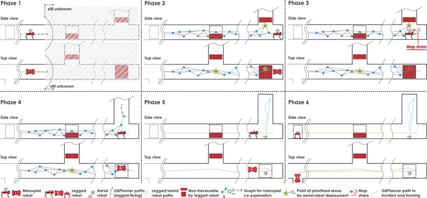
parts of the environment un-traversable for the legged robot
and only accessible using an aerial robot. Second, the size of
the environments imposed an endurance limitation for sole
exploration of these environments by using only the aerial
robot, hence, necessitating a marsupial deployment.
   1) Exploration of an Unreachable Elevated Platform: The
first experiment was conducted in an underground garage at
ETH Zurich, as shown in Figure 4. This environment consisted
of a garage parking area connected to a mezzanine level with a
step height of 1.0 m, making it unreachable for the ANYmal
robot. During this mission, the robots started autonomous
exploration of the garage in marsupial configuration. Once
ANYmal completed exploration of the lower level the only
exploration frontier left was on the mezzanine level. At this
point, the planning stack of ANYmal issued a command
to deploy the aerial robot. The RMF-Owl autonomously
took-off from the ANYmal and proceeded to explore the
mezzanine level, after which it returned to its start position
and autonomously landed. The ANYmal robot returned to
its mission start position after deploying the aerial robot as
there was no remaining information gain available in the          Fig. 5. Autonomous exploration in marsupial configuration of a branching
environment for exploration purposes.                             corridor physically blocked by metal containers. The top row shows the end
   2) Exploration of a Blocked Environment Section: A             of the exploration phase of the ANYmal robot while carrying the RMF-
                                                                  Owl. The middle row shows the positioning of the marsupial system at the
second experiment was conducted in the basement of the            identified deployment position near the exploration area (blue circles) for
CLA building at ETH Zurich. During this experiment, a             the aerial robot. The bottom row shows the autonomous exploration of the
branching corridor was physically blocked by metal containers     aerial robot while the legged robot returns to mission start position.
making it inaccessible for the ANYmal robot. However, due
to high ceiling clearance, the corridor can be accessed by        in marsupial configuration started autonomous exploration
the aerial robot by flying over the blockage. As shown            in a small room shown in the top row of Figure 6 as the
in Figure 5, the robots start autonomous exploration in           leftmost part of the map . After autonomously exploring
marsupial configuration and once all the ground accessible        approximately 100 m into the environment the robot detects
areas are explored by the ANYmal robot, it returns to the         a branching path, as shown in the top row of Figure 6,
site of blockage and chooses to deploy the aerial robot.          with potential exploration frontiers detected in diverging
The aerial robot autonomously takes off and pursues an            directions. At this instance, the legged robot chooses to
exploration frontier identified above the blockage. Once          deploy the aerial robot to pursue exploration along one of
RMF-Owl reaches the exploration frontier, it identifies more      the frontiers. Current missions maps and target exploration
exploration gain in the corridor behind the blockage and starts   direction bounds are given from ANYmal to RMF-Owl.
autonomous exploration until its endurance limit is reached.      After performing co-localization, the legged robot releases
After deploying the aerial system, the ANYmal robot returns       the aerial robot’s safety strap and RMF-Owl autonomously
to mission start point autonomously.                              takes off to start exploration, while ANYmal proceeds to
   These experiments demonstrate the real-world practical         explore the second frontier, as shown by the diverging paths
need for a robotic system-of-systems approach for exploration     of both robots in the middle row of Figure 6. Both robots
of complex environments by exploiting the complementary           complete their exploration missions by reaching the dead
navigation capabilities of heterogeneous robots in settings       ends of their individual exploration areas and, as there is
where otherwise complete exploration is not possible.             no more exploration gain, choose to autonomously return
                                                                  to their initial deployment positions. Please note that the
B. Autonomous Exploration of Multi-branch Environments            RMF-Owl returns to its known deployment position from the
   To demonstrate the real-world application potential of         ANYmal robot rather than the start position of the mission
marsupial system-of-systems for exploration of multi-branch       as its remaining flight endurance would not have allowed
environments, a test was conducted in the utilities basement of   it. While homing towards the mission start position, the
the main building at ETH Zurich. The environment consists of      ANYmal robot passes by the RMF-Owl and, upon establishing
a set of narrow corridors running under the building branching    communication, retrieves and appends maps from the aerial
at a certain point to connect the main building basement to       robot to its onboard maps, as shown in the in the bottom
that of a neighboring building. The total path length traversed   row of Figure 6. This experiment demonstrates the potential
by both robots during autonomous exploration was 400 m,           and benefit of employing system-of-systems configuration
with instances of the mission and the full explored map           of heterogeneous robots to explore disjointed sections of
shown in Figure 6. During this experiment, the ANYmal robot       large-scale and complex environments efficiently.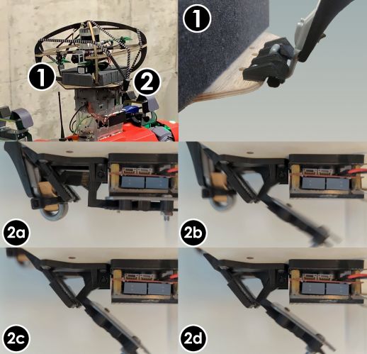
[2] T. Dang, M. Tranzatto, S. Khattak, F. Mascarich, K. Alexis, and
                                                                                    M. Hutter, “Graph-based subterranean exploration path planning using
                                                                                    aerial and legged robots,” Journal of Field Robotics, 2020.
                                                                                [3] A. Agha et al., “Nebula: Quest for robotic autonomy in challenging
                                                                                    environments; team costar at the darpa subterranean challenge,” arXiv
                                                                                    preprint arXiv:2103.11470, 2021.
                                                                                [4] B. Englot and F. S. Hover, “Three-dimensional coverage planning for
                                                                                    an underwater inspection robot,” The International Journal of Robotics
                                                                                    Research, vol. 32, no. 9-10, pp. 1048–1073, 2013.
                                                                                [5] R. R. Murphy et al., “Robot-assisted bridge inspection,” Journal of
                                                                                    Intelligent & Robotic Systems, vol. 64, no. 1, pp. 77–95, 2011.
                                                                                [6] S. Scherer et al., “Resilient and modular subterranean exploration with
                                                                                    a team of roving and flying robots,” Submitted to the Journal of Field
                                                                                    Robotics, 2021.
                                                                                [7] T. Miki, J. Lee, J. Hwangbo, L. Wellhausen, V. Koltun, and M. Hutter,
                                                                                    “Learning robust perceptive locomotion for quadrupedal robots in the
                                                                                    wild,” Science Robotics, vol. 7, no. 62, p. eabk2822, 2022.
                                                                                [8] M. Hutter et al., “Anymal-a highly mobile and dynamic quadrupedal
                                                                                    robot,” in IEEE International conference on intelligent robots and
                                                                                    systems (IROS), 2016, pp. 38–44.
                                                                                [9] P. D. Petris, H. Nguyen, M. Dharmadhikari, M. Kulkarni, N. Khedekar,
                                                                                    F. Mascarich, and K. Alexis, “Rmf-owl: A collision-tolerant flying
                                                                                    robot for autonomous subterranean exploration,” 2022.
                                                                               [10] F. Marques et al., “A critical survey on marsupial robotic teams for
                                                                                    environmental monitoring of water bodies,” in OCEANS 2015 - Genova,
                                                                                    2015, pp. 1–6.
                                                                               [11] M. Kalaitzakis et al., “A marsupial robotic system for surveying and
                                                                                    inspection of freshwater ecosystems,” Journal of Field Robotics, vol. 38,
                                                                                    no. 1, pp. 121–138, 2021.
                                                                               [12] M. J. Schuster et al., “The arches space-analogue demonstration
                                                                                    mission: Towards heterogeneous teams of autonomous robots for
                                                                                    collaborative scientific sampling in planetary exploration,” IEEE
                                                                                    Robotics and Automation Letters, vol. 5, no. 4, pp. 5315–5322, 2020.
Fig. 6.    Autonomous exploration of multi-branch environments using           [13] J. Moore et al., “Nested marsupial robotic system for search and sam-
heterogeneous robots. The top row shows ANYmal and RMF-Owl starting the             pling in increasingly constrained environments,” in IEEE International
mission in marsupial configuration and reaching a section of the environment        Conference on Systems, Man, and Cybernetics (SMC), 2016.
containing diverging paths. The middle row shows deployment of the aerial      [14] S. Ren, Y. Chen, L. Xiong, Z. Chen, and M. Chen, “Path planning
robot and the map shows the exploration paths of ANYmal (Green) and                 for the marsupial double-uavs system in air-ground collaborative
RMF-Owl (Red) in disjoint branches of the environment. The bottom row               application,” in 37th Chinese Control Conference (CCC), 2018.
shows ANYmal onboard map from ANYmal and its path after autonomously           [15] J. C. Las Fargeas, P. T. Kabamba, and A. R. Girard, “Path planning
returning to mission start position. The final onboard map of ANYmal                for information acquisition and evasion using marsupial vehicles,” in
contains regions explored by RMF-Owl as they were during homing.                    2015 American Control Conference (ACC), 2015, pp. 3734–3739.
                                                                               [16] C. Y. H. Lee, G. Best, and G. A. Hollinger, “Stochastic assignment for
                                                                                    deploying multiple marsupial robots,” in IEEE International Symposium
                          V. C ONCLUSIONS                                           on Multi-Robot and Multi-Agent Systems (MRS), 2021.
                                                                               [17] B. Allen and T. Chung, “Unearthing the subterranean environment,”
   This work proposed a complete solution for the marsupial                         2021. [Online]. Available: https://www.subtchallenge.com/
legged-and-aerial robotic system-of-systems exploration and                    [18] P. G. Stankiewicz et al., “A motion planning approach for marsupial
                                                                                    robotic systems,” in IEEE International Conference on Intelligent
mapping deployment. The proposed approach efficiently                               Robots and Systems (IROS), 2018.
utilizes the complementary capabilities of walking and                         [19] K. M. Wurm et al., “Coordinated exploration with marsupial teams
flying systems and mitigates their individual limitations by                        of robots using temporal symbolic planning,” in IEEE International
                                                                                    Conference on Intelligent Robots and Systems, 2010.
exploiting their synergy. The solution offers bi-directional map               [20] M. Bloesch, M. Burri, H. Sommer, R. Siegwart, and M. Hutter, “The
sharing, enables co-localization between robots and facilitates                     two-state implicit filter recursive estimation for mobile robots,” IEEE
collective map building. Simultaneously, the exploration path                       Robotics and Automation Letters, vol. 3, no. 1, pp. 573–580, 2017.
                                                                               [21] P. Allgeuer, M. Schwarz, J. Pastrana, S. Schueller, M. Missura, and
planning is treated in a unified manner by first allowing each                      S. Behnke, “A ros-based software framework for the nimbro-op
system to explore individually but also enabling the ground                         humanoid open platform,” arXiv preprint arXiv:1809.11051, 2018.
robot to decide where and when to deploy the aerial and how                    [22] S. Khattak et al., “Complementary multi–modal sensor fusion for
                                                                                    resilient robot pose estimation in subterranean environments,” in IEEE
to direct its exploration task. Extensive experimental results                      International Conference on Unmanned Aircraft Systems, 2020.
using the marsupial integration of ANYmal-C and RMF-Owl                        [23] J. Zhang and S. Singh, “Low-drift and real-time lidar odometry and
robots demonstrate that the system-of-systems approach can                          mapping,” Autonomous Robots, vol. 41, no. 2, pp. 401–416, 2017.
                                                                               [24] M. Kulkarni and others, “Autonomous teamed exploration of sub-
enable the autonomous exploration and mapping of areas that                         terranean environments using legged and aerial robots,” in IEEE
could not have been fully covered using a single system in                          International Conference on Robotics and Automation (ICRA), 2022.
an efficient manner.                                                           [25] H. Oleynikova et al., “Voxblox: Incremental 3d euclidean signed
                                                                                    distance fields for on-board mav planning,” in IEEE International
                                                                                    Conference on Intelligent Robots and Systems (IROS), 2017.
                             R EFERENCES

 [1] M. Tranzatto et al., “Cerberus: Autonomous legged and aerial robotic
     exploration in the tunnel and urban circuits of the darpa subterranean
     challenge,” Field Robotics, 2021.
You can also read