May 2020 Climate Summary for Denver Warmer & Drier Than Normal
←
→
Page content transcription
If your browser does not render page correctly, please read the page content below
May 2020 Climate Summary for Denver
                     Warmer & Drier Than Normal
The month started out warm and dry as upper level high pressure extended from the Rockies into
the Central Plains States. An upper level disturbance and associated cold front brought much
cooler temperatures and precipitation to north central and northeastern Colorado on the 2nd.
Denver experienced dry weather and seasonable temperatures from the 3 rd through the 7th. A
strong upper level disturbance and a dry cold front produced strong winds across the
northeastern plains on the 7th with a 65 mph wind gust from the northwest recorded at DIA. Below
are some other wind reports across northeastern Colorado.

                                           65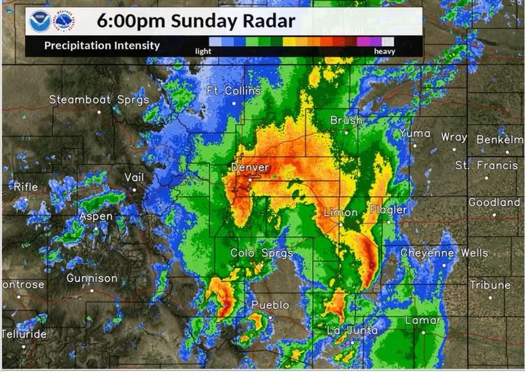
A deep upper level trough of low pressure dominated the central and eastern U.S from the 8 th
through the 11th with a large upper level ridge of high pressure centered over the western states.
Colorado was in-between these two systems under the influence of a northwesterly flow aloft. This
pattern allowed a series of cold fronts to move across northeastern Colorado resulting in below
normal temperatures. Dry weather prevailed through this period with the exception of some
precipitation on the 11th. Typical weather returned on May 12th and continued through the 17th with
. with the daily round of afternoon and evening showers and storms.
temperatures in the 70s along
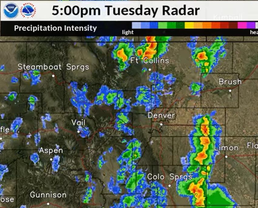
Strong thunderstorms moving across portions of
Northeastern Colorado on the afternoon of the 15th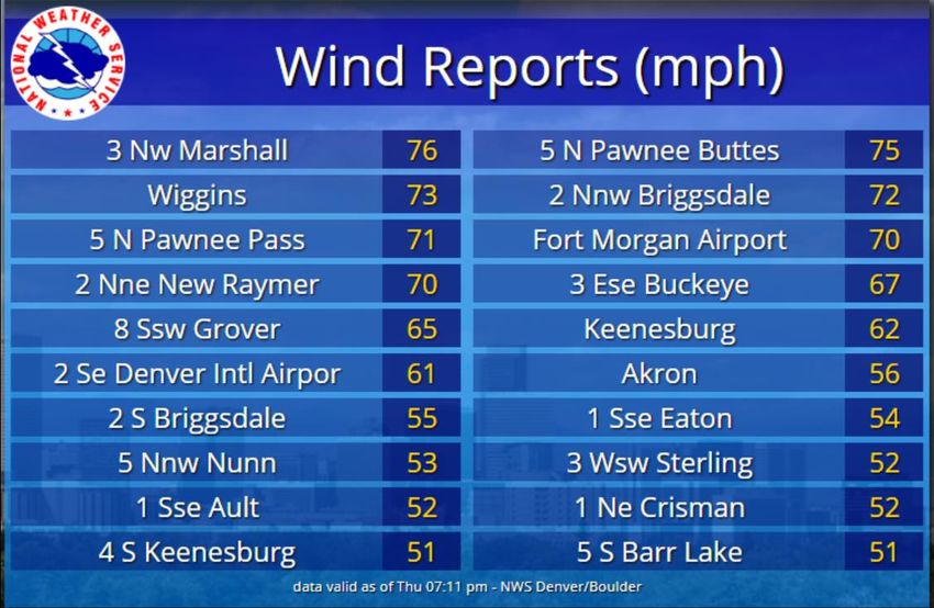
A strong upper level ridge   of high pressure combined with a dry southwesterly downslope flow
resulted in hot and mostly   dry weather from the 18th through the 20th During this period, high
temperatures on the plains   were in the upper 80s to lower 90s. Some strong storms with hail, brief
heavy rain and gusty winds   did develop late in the afternoon of the 19 th but the storms managed to
stay well north, south and   east of Metro Denver.

                                                                              May 19th

                         Strong thunderstorms moving across portions of
                         Northeastern Colorado on the afternoon of the 15th
During the early evening of May 20, 2020, six
landspout tornadoes occurred in the Eaton and
Greeley area in Weld County which is
approximately 40 miles to the north of Denver
International Airport.

The tornadoes were weak enough that only a few
reports of damage were received by the NWS
Boulder office, and all damage was consistent
with the EF-0 rating. Three farmsteads were
impacted with minor damage, and there were no
injuries or deaths.

The landspout tornadoes developed along a dry
line which had moist air to the east and very
dry air to its west. Denver was on the dry
side of this boundary with hot temperatures
and gusty southerly winds.

A landspout tornado is a narrow, rope-like
funnel that forms while the thunderstorm cloud
is still growing and there is no rotating
updraft - the spinning motion originates near
the ground, typically along a near-surface
boundary between two different, converging air
masses.

We would like to thank all of our storm
spotters for all
of their storm reports and great photos.

                                                 Photo taken by Greg Polese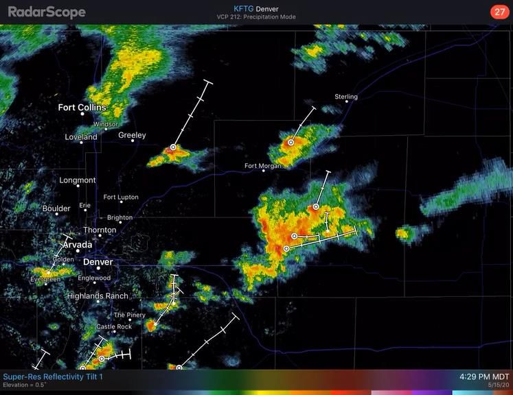
Temperatures returned to near normal values from the 21st through the 23rd as a cooler airmass
associated with an upper trough over the Great Basin approached Colorado from the west. Denver
experienced much cooler & wetter weather on the 24th as the upper trough of low pressure and cold
front moved across the state. Most of north central and northeastern Colorado received beneficial
rainfall with many locations across Metro Denver and the Palmer Divide receiving over an inch of
precipitation.

                        Low Clouds on the Flatirons After a Rain Late Afternoon of the 24th
Showers & thunderstorms which moved off the foothills brought beneficial rainfall to the Front
Range Urban Corridor, Palmer Divide & adjacent plains on the afternoon & evening of the 24 th.
Many locations measured over an inch of precipitation. Temperatures rebounded on the 26 th as upper
level high begin to build into Colorado from the west. Temperatures gradually warmed to near 90
across northeastern Colorado by the end of the month.
TEMPERATURES:
The average temperature at Denver International Airport for the month of May was 59.6 degrees F
which is 2.5 degrees above the normal of 57.1 degrees. There were two days in the month (19 th
and 20th) in which the temperature reached or exceeded the 90 degree mark. The max Temperature
of 92 degrees on the 19th set a new record high temperature for the date. The old record was 90
degrees set back in 2009. The coldest temperature of 30 degrees occurred on the morning of the
5th.

Ten Warmest May Average Temperature in Denver Weather History
SINCE 1872: DEGREES F

64.7   -   1934
63.2   -   1994
62.0   -   1886
61.7   -   1958
61.6   -   1974, 1879
61.5   -   1939
61.4   -   2018
61.3   -   1936
61.1   -   1875

Ten Coldest May Average Temperature in Denver Weather History
SINCE 1872: DEGREES F

48.7   -   1917
50.0   -   1995
50.1   -   1935
50.3   -   1907
51.4   -   1983
51.5   -   1892
51.6   -   2019
52.0   -   1946
52.6   -   1967
52.7 - 1924
PRECIPITATION:
Denver received 1.65 inches of precipitation during May of 2020. This is 0.47   inches below the
monthly average of 2.12 inches. The highest daily precipitation amount of THE   HIGHEST DAILY
PRECIPITATION AMOUNT OF 0.94 occurred during the afternoon and evening of the   24th. No snow was
measured at Denver International Airport which is 1.1 inches below the normal   of 1.1 inches.

TEN WETTEST MAY TOTALS IN DENVER WEATHER HISTORY SINCE 1872:

INCHES
8.57 -   1876
7.31 -   1857
6.12 -   1969
5.06 -   1973
4.95 -   1935
4.88 -   1938, 1898
4.79 -   2011
4.77 -   1967
4.67 -   1995

TEN DRIEST MAY TOTALS IN DENVER WEATHER HISTORY SINCE 1872:

INCHES
0.06 -   1974
0.09 -   1886
0.15 -   1899
0.22 -   1919
0.34 -   1977, 1966
0.43 -   1925
0.49 -   1972
0.52 -   1911
0.53 -   1900
SNOWFALL:

May is Denver’s least snowiest month of the snow season with a monthly average of 1.1 inches
(NCEI 1980-2010). No snow fell during May of 2020 which is 1.1 inches below normal.

TEN HIGHEST SNOW TOTALS FOR MAY IN DENVER WEATHER HISTORY

INCHES
15.5 -      1898
13.7 -      1950
13.5 -      1978
13.2 -      1912
12.0 -      1917
10.0 -      1908
 9.0 -      1907
 8.9 -      1893
 8.8 -      1957
 8.3 –      1944

Least snowiest May’s in Denver Weather History:

There have been numerous times in which Denver received no snowfall during the month of May.

-------------------------------------------------------------------------------------------------------------------------------------------------------------------------
Weather:
There were 7 days with thunder and no days with hail observed at Denver International Airport
in May of 2020. In addition, there was only 1 day with dense fog with a visibility at or below
¼ mile. The strongest wind gusts during the month was 65 mph from the northwest on the 7 th.
You can also read