MINERAL PROSPECTIVITY MAPPING - Vesa Nykänen Research Professor Geoinformatics, Information Solutions
←
→
Page content transcription
If your browser does not render page correctly, please read the page content below
1

MINERAL PROSPECTIVITY MAPPING

                                                       Vesa Nykänen
                                                        Research Professor
                                              Geoinformatics, Information Solutions
                                                 Geological Survey of Finland GTK
                                             P.O. Box 77, FI‐96101 Rovaniemi, Finland
       This project is funded by the European Union

March 9th 2021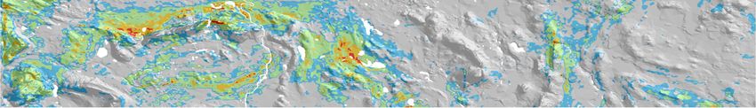
2

CONTENT
                 GTK public geodata
                 Prospectivity mapping
                 Available tools
                 Practical examples
                 • Orogenic gold prospectivity
                 • IOCG prospectivity
                 • Ni‐Cu prospectivity

                 Summary

March 9th 2021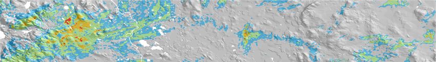
GTK SPATIAL DATA
                                                                                     3

                 •   Geological maps
                 •   Mineral resources
                      •   Mineral deposits
                      •   Metallogenic belts
                 •   Airborne and ground geophysics
                      •   Gravity
                      •   Magnetics
                      •   Electromagnetics
                      •   Radiometrics
                 •   Geochemistry
                      •   Till
                      •   Bedrock
                      •   Boulder samples
                      •   Drilling data
                      •   Ore showings

                 •   All this data is publicly available (https://hakku.gtk.fi/en)
March 9th 2021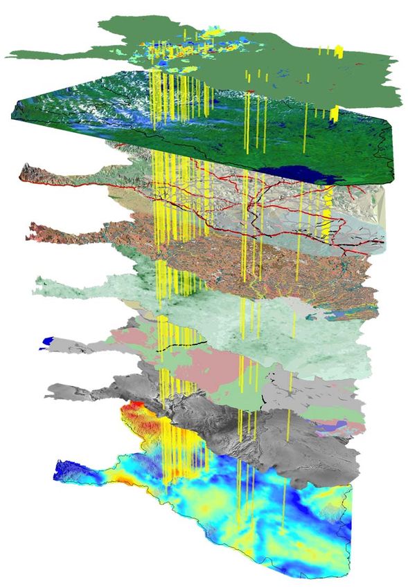
EXPLORATION POTENTIAL MAPPING /
                                                                                             4

MINERAL PROSPECTIVITY MAPPING
      Traditionally based on expert opinions on potential areas for a certain deposit type
      Digital maps allow quantitative analysis of data and numerical modeling for mineral
      prospectivity mapping (also known as mineral potential mapping) ‐> Vast
      exploration data requires GIS based data‐analysis and spatial data mining
      techniques
      Aim is to delineate areas favorable for mineral exploration, being time‐saving, cost
      effective and environmentally neutral exploration technique

March 9th 2021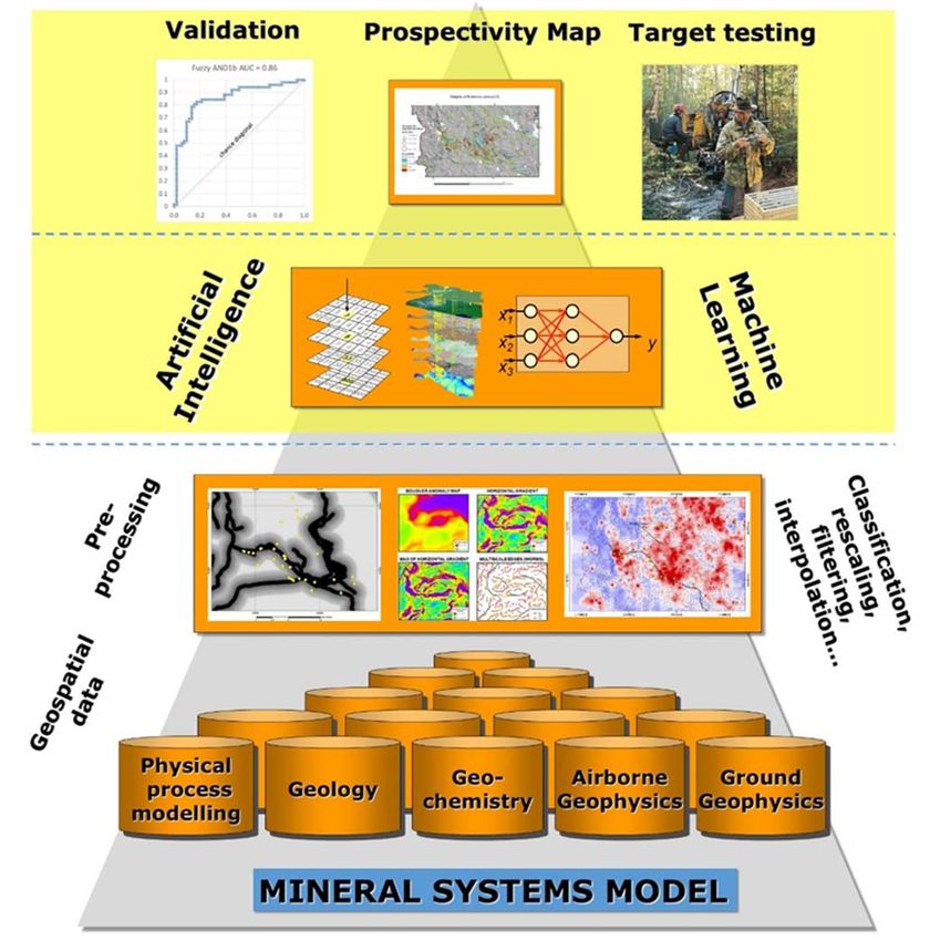
DYNAMIC PROSPECTIVITY MAPPING                       5

 METHODOLOGY
                  4. Validation:
                  Statistical and field validation

                  3. Spatial analysis:
                  Machine learning and AI
Dynamic
loop and
iteration         2. Input pattern
                  generation – proxies
                  for critical parameters

                  1. Selection of the
                  relevant data based
                  on a mineral system model
                  – critical parameters

 March 9th 2021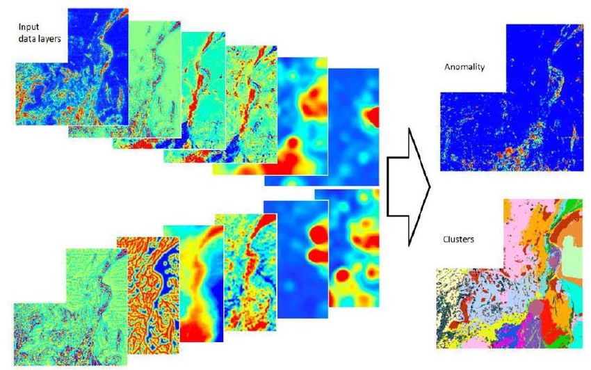
METHODS FOR MINERAL PREDICTIVE MAPPING
                                                                                             6

(MPM) – KNOWLEDGE VS. DATA DRIVEN
                                   Knowledge driven approaches
                                    •   We know controlling factors and use that knowledge
                                    •   We can find only what we know
                                    •   We do not need training points
                                    •   Fuzzy logic, mathematical rules
                                   Data driven approaches
                                    • The algorithm finds the dependencies by itself
                                    • We need training points
                                    • Weights of evidence, artificial neural networks,
                                        random forests, regression
                                   Hybrid approaches
                                    • Combinations of the above
                                    • Neuro‐fuzzy system (NFS)

March 9th 2021   Source: Andreas Knobloch, Beak Consultants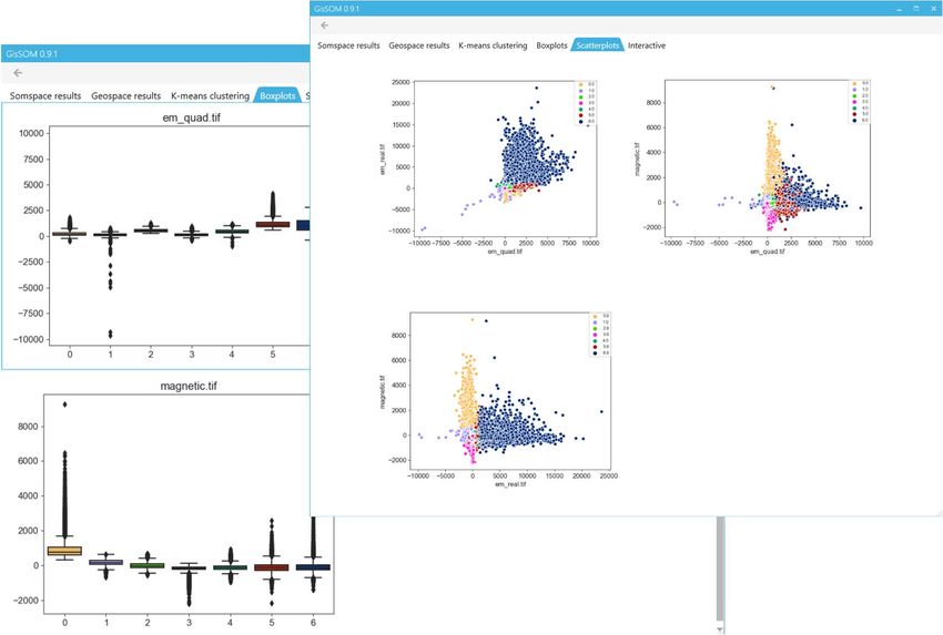
7

DATA PREPROCESSING PHILOSOPHY
                     Garbage In,                 Good Data In, Good
                     Garbage Out                Resource Appraisal Out

                               Geology                               Geology
                               Geophysics                            Geophysics
                               Remote Sensing                        Remote Sensing
                               Geochemistry                          Geochemistry

                        GIS                                GIS

                 Analyse / Combine                Analyse / Combine

                 Prospectivity Maps               Prospectivity Maps

                                                  Courtesy of Dr. Stephen Gardoll

March 9th 2021
8

                  DATA DRIVEN (EMPIRICAL) APPROACH
                          Weights of evidence, logistic regression                            Artificial Neural Networks

                                                                                                                Supervised:
                                                                                                                RBFLN, PNN, Fuzzy NN

                                                                                                                Unsupervised:
                                                                                                                SOM

                                      Combined till geochemistry: As, Au, Cu, Fe, Ni and Te
Evidence layers

                                      Airborne magnetics: magnetic field total intensity
                                      Airborne electromagnetics: apparent resistivity

                                      Gravity: horizontal gradient
                                                                                                          x1

                                      Bedrock geology
                                                                                                          x2                               y
                                                                                                          x3
                  March 9th 2021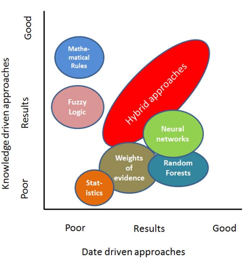
KNOWLEDGE DRIVEN (CONCEPTUAL)
                                                                                                           9

APPROACH
 Fuzzy logic

      Step 1: Definition of the mineral system model/Exploration model
      Step 2: Select data sets based on the mineral system/exploration model and data available
      Step 3: Assign fuzzy membership values e.g., rescale all data into a common scale from 0 ‐> 1
      (e.g., not favorable ‐> favorable) using Fuzzy membership tool
      Step 4: Combine all the evidence data by using various fuzzy operators (Fuzzy OR, Fuzzy AND, Fuzzy
      Sum, Fuzzy Product, Fuzzy Gamma)
      Step 5: Validate your model (statistical or empirical methods)
      Step 6: Refine your model and repeat if needed !
March 9th 2021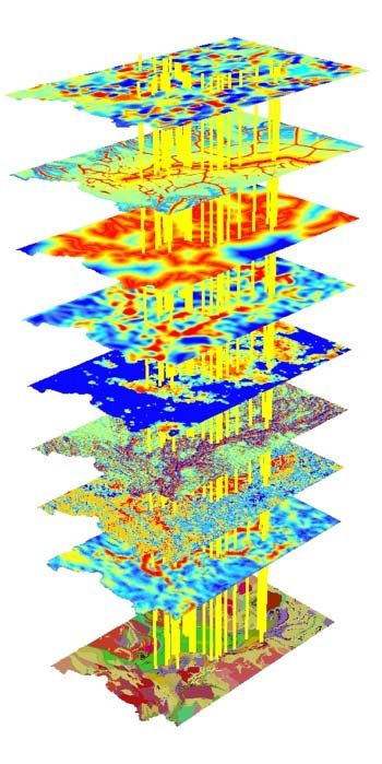
ARCSDM 5
                                                                                                 10

TOOLBOX FOR PROSPECTIVITY MAPPING
      ArcSDM was originally developed by Gary Raines (USGS) and
      Graeme Bonham‐Carter (GSC) and was coded by Don Sawatzky (USGS)
      ArcSDM has been maintained by Prof. Carlos Roberto de Souza Filho,
      University of Campinas, Sao Paolo, Brazil, http://www.ige.unicamp.br/sdm/
      GTK has recoded the tools into ArcGIS 10.4 and ArcGIS Pro platforms and also implemented
      some new tools in 2017‐2018. Tools available from: https://github.com/gtkfi/ArcSDM
      Download ZIP file to your computer and add toolbox(es) into your ArcGIS map document

March 9th 2021
11
MPM ONLINE TOOL
Conceptual fuzzy logic prospectivity modelling tools using the
geological, geophysical and geochemical data provided by web map
applications ‐> http://gtkdata.gtk.fi/mpm/
March 9th 2021The NEXT Project
New Exploration Technologies for a More Efficient, Economic and Environmentally Friendly Ore Exploration
Input
data
Development of data integration methodology layers
Anomality
and workflows for the different study areas and
deposit types
NEXT has developed a reliable, easy‐to‐use self‐
organizing map (SOM) software tool devoted
Clusters
to data integration and spatial data analysis
We aim to create predictive maps for the
investigated study areas and the different
deposit types based on the developed data
integration techniques of SOM and the Example of data integration: multiple input data layers
from geophysics and geochemistry are combined to
available technique of the ANN produce maps showing either the level of anomality of
each pixel or the areas with similar properties.
Source: Torppa J., Middleton M., Hyvönen E.,
Lerssi J. and Fraser S., 2015
This project is funded by the European Union13
GISSOM
GisSOM performs SOM clustering
and optionally also k‐means
clustering.
Displays the results in SOM and
geospaces.
Visualizes the data distribution in k‐
means clusters as box and scatter
plots.
In SOM space, labelled data (e.g.
locations of known deposits) can be
shown on the cluster map indicating
which clusters are prospective.
Tool available at GitHUB:
https://github.com/gtkfi/GisSOM
March 9th 2021PROSPECTIVITY MODEL CAN BE BASED ON A THEORETHICAL 14
MINERAL SYSTEM MODEL OR ALTERNATIVELY ON A PRACTICAL
EXPLORATION MODEL
OVERPRINT
GENETIC MODEL: secondary trap or
epigenetic dispersion
SINK
• Source of metals & fluids:
rocks hypogenetic dispersion and
alteration
undergoing metamorphism in depth REMOBILISATION TRAP
local structures + fluid flow local structures and
• Pathway: (transcrustal) shear/thrust geochemical barriers
zones (during active seismic phase(s)) Metals FOOTPRINT
hypogenetic alteration
• Trap: reactive rocks, contrasting
rheologies, structural traps (jogs, low TRANSIENT TRAP
secondary source
TRANSPORT
permeability seals, folds) crustal scale structures
• Formation of orogenic‐Au deposits is
Transporting
essentially a metamorphic process – agents
Metals
intrusives may contribute, but are not Geodynamic PRIMARY SOURCE
neccesary for the process! processes lower crust Model by Ferenc Molnar
mantle
March 9th 2021INPUT LAYERS FOR OROGENIC GOLD
15
PROSPECTIVITY MODELS
March 9th 2021DATA DRIVEN (WEIGHTS OF EVIDENCE)
16
OROGENIC GOLD PROSPECTIVITY MODEL
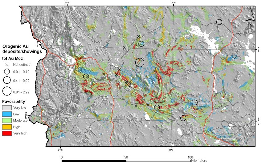
March 9th 202117
KNOWLEDGE DRIVEN (FUZZY LOGIC) REGIONAL
SCALE OROGENIC GOLD PROSPECTIVITY
AUC = 0.67 AUC = 0.90
AUC = 0.89
Apparent Metamorphic
resistivity grade
AUC = 0.86
AUC = 0.68
AUC = 0.86
Gravity
gradient
Lithology/
permissive tracts
Fuzzy Gamma (γ=0.75)
Till geochem.
Te, Cu, Co, Fe
March 9th 2021KNOWLEDGE‐DRIVEN (FUZZY LOGIC) 18
PROSPECTIVITY MODEL FOR IRON OXIDE‐CU‐AU
(IOCG) DEPOSITS IN NORTHERN FINLAND
• IOCG prospectivity map U-radiating AM-highs Proximity to Cu-showings
Major structures related
to domain boundaries
AUC = 0.96
Presence of Magnetite Presence of Sulfides Alteration chemistry
Fuzzy GAMMA 0.87
March 9th 202119
KNOWLEDGE DRIVEN (FUZZY LOGIC) MAGMATIC NICKEL‐
COPPER PROSPECTIVITY MODEL FOR CENTRAL LAPLAND 25 °E 26 °E 27° E
68 °N
68° N
67°50 'N
67°50' N
67 °40 'N
67°40' N
67 °30 'N
67°30' N
25° E 26° E 27° E
Km
0 5 10
20 °E 2 5°E 30° E
Min ing con cessio n
69°N
69 °N
Cla im (Ni- Cu)
Cla im ap pl icatio n
Rese rva ti on
•Prospectivity map
66°N
66 °N
Ni prospec tiv ity combining AM,
Ver y lo w
gravity and till
63°N
63°N
Lo w
Mo der ate
Hig h
geochemistry
60°N
60 °N
20° E 2 5°E 30° E Ver y h ig h
March 9th 202120
SUMMARY:
ArcSDM5 available from GITHub https://github.com/gtkfi/ArcSDM
• Up to following versions: ArcGIS Desktop 10.5, ArcGIS Pro 2.2
GisSOM available from GITHub https://github.com/gtkfi/GisSOM
MPM on‐line http://gtkdata.gtk.fi/mpm/
Hot topics:
• Use of mineral system parameters
• New automated “artificial intelligence” type of
modeling tools
• Deep learning
• Machine learning
• SOM
• 3D prospectivity modeling
March 9th 2021The NEXT Project
New Exploration Technologies for a More Efficient, Economic and Environmentally Friendly Ore Exploration
NEXT key figures
Call: H2020‐SC5‐13c‐2016‐2017
‐ New solutions for sustainable
production of raw materials
Duration: 01.05.2018 –
30.04.2021
Coordinator: Geological
Survey of Finland
Consortium: 16 partners
from 6 EU countries
This project is funded by the European UnionThank you for your attention!
Download ArcSDM https://github.com/gtkfi/ArcSDM
More info: http://projects.gtk.fi/mpm
March 9th 2021
This project is funded by the European Union
22You can also read