Mitigation of Urban Flooding by using Green Infrastructure in Surat, India
←
→
Page content transcription
If your browser does not render page correctly, please read the page content below
International Journal of Environmental Research and Development.
ISSN 2249-3131 Volume 10, Number 1 (2020), pp. 1-17
© Research India Publications
http://www.ripublication.com

        Mitigation of Urban Flooding by using Green
                Infrastructure in Surat, India

                            Ar Jigna Ashokkumar Vanjara
          Rachana Sansad’s Institute of Environmental Architecture, Mumbai,
                           Maharashtra 400025, India.

                                        Abstract
     Urban flooding is a serious and growing development challenge. Against the
     backdrop of demographic growth, urbanization trends and climate changes, the
     causes of floods are shifting and their impacts are accelerating. This paper
     describes the flood risks faced by Surat, one of India’s most commercially
     successful and also most flood-prone cities. The city is located on the lower
     basin of Tapi River,94 km downstream of Ukai dam and flows into 15 km far
     Arabian sea. Hence, city is prone to flooding not only from heavy precipitation
     in and around the city but also from heavy precipitation upstream and from high
     tides downstream, causing loss of life, damage to homes and disruption to
     businesses.
     Reducing the risks from upstream depends on better water management in a
     water catchment area and dam reservoir located far outside the city authority’s
     jurisdiction and in another state. However, this research aims to review
     alternative techniques for reduction in increasing stormwater run-off caused due
     to fast growing urbanization of the city with more area getting paved with
     concrete and impervious surfaces not letting the water to soak into the ground.
     Therefore, this paper focusses on comparative analysis of effectiveness of each
     technique implemented by increasing green area in catchments and delaying and
     retaining the part of the run-off to help reduce flooding.
     Keywords: Surat, River Tapi, Stormwater Run-off management, Urban
     Flooding, Green Infrastructures, Flood Reduction Plan

1.      INTRODUCTION
Surat is located in the western part of India in South Gujarat region, is a very dynamic
city with a fast growth-rate due to immigration from various parts of India. The city of
Surat is situated at latitude 21deg12’N and longitude 72deg52’E on the bank of river
Tapi having coastline of Arabian Sea on its West. It has a population estimated at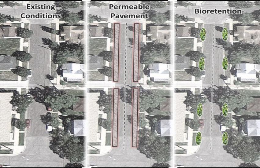
2                                                       Ar Jigna Ashokkumar Vanjara

around 45 lacs. It has a summer temperatures ranging from 37 deg C to 44 deg C.
Annual average rainfall is around 1,200 millimetres, with around 90 per cent of this
falling between June and September and with very little rainfall between December and
May. The city is located on the bank of the river Tapi with a walled city at its center.
The topography is controlled by the river and is flat in general and the gentle slope is
from north-east to south-west. The city is known for its textile trade and diamond
cutting and polishing industries. Surat Municipal corporation area is about 326.51
sq.km which was 112 sq.km before extension of city. (July 2006). (Surat Municipal
Corporation, 2015)

               Area of Surat and Location Of river Tapi. (Bhakuni)

      Location Map of Lower Tapi Basin(LTB), Ukai Dam, Surat City with
                       administrative Zone Boundary.
                     Source: (Surat Municipal Corporation, 2015)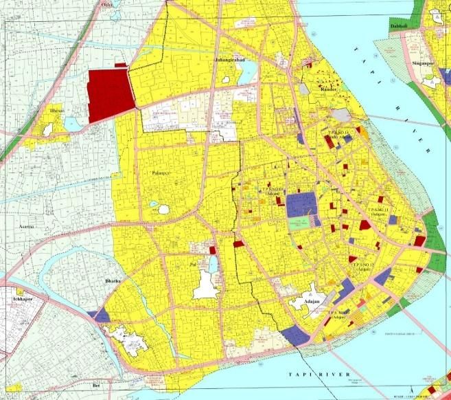
Mitigation of Urban Flooding by using Green Infrastructure in Surat, India                3

2.     CAUSES AND EXTENT OF OVERALL IMPACT OF FLOODING
The Tapi River is divided in three zones, i.e. Upper Tapi basin, Middle Tapi Basin, and
Lower Tapi Basin (LTB).
The portion between Ukai Dam to Arabian Sea has been considered as LTB, mainly
occupying Surat and Hazira twin city along with tens of small towns and villages along
the river course. The Surat and Hazira twin cities are downstream of Ukai Dam almost
94 km distance and are affected by recurrence floods at regular intervals. LTB receive
an average annual rainfall of 1200 mm, and these heavy downpours result into
devastating floods and water loggings mainly between Ukai dam and Hazira town
downstream.
Flooding remains Surat’s most persistent long-term vulnerability, especially as climate
change affects the water cycle. Recent years have seen fewer rainy days in the year, but
more intense rainfall on those days, increasing the flood risk. On top of that, rising sea
levels are expected to cause higher tides that could cause Tapi to flood more frequently.
The main reasons for flooding in Surat depend on heavy rainfall and discharge due to
high water levels from Ukai dam. Therefore, the flood problems of the river system are
inundation due to over flowing of the banks. High tide during certain period from
Arabian sea also play significant role in flood formation for this city. (Sudhakar BS A.
K., 2015)
Surat is usually affected by two types of floods: Tapi River flood and Khadi flood. Tapi
river flood occurs due to heavy inflow of rainfall in Tapi basin while Khadi flood occur
due to heavy rainfall in city and tidal effect of the sea.

2.1 Tapi River Carrying Capacity and River Basin.
Due to construction of Weir cum cause way on river Tapi reservoir is formed on
upstream side of river which led to stagnation of flowing river water. The stagnation of
river water give rise to growth of algae and weeds hence raw water quality get
deteriorated which causes problem in intake well as well as in subsequent treatment
process. Moreover, sewage discharge from some of the area has created terrible impact
on river water quality on upstream of river. Also, Sewage discharge enhances the
growth of algae, weeds and other vegetation which causes synergistic effect on river
water quality.
Due to tidal influences, river water becomes brackish in the downstream of weir in river
Tapi. Owing to these problems, the bore water of adjacent area becomes salty and not
fit for drinking. (1)
(1) - ( Integrated sustainable urban water network using statistical and analytical
heirarchy process modeling technique: a case study of surat city)
Hence, Tapi River near Surat is reported to have been significantly reduced from 10 to
3.5 lacs due to: encroachment in the flood plain areas, silting in the river-bed, and afflux
caused by the Singanpore weir constructed on the river very close to the city.
4 Ar Jigna Ashokkumar Vanjara
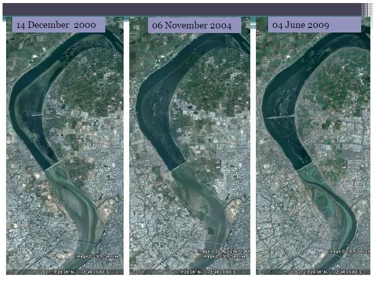
Shift in River Tapi and storage of water at weir cum cause way,
hence shrinkage of river downstream due to siltation.
Embankments and Retaining Walls
Source: (G. I. JOSHI, August 2014)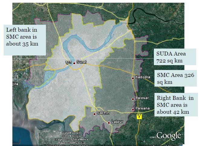
Mitigation of Urban Flooding by using Green Infrastructure in Surat, India              5

2.2 Flood of 2006
Owing to unprecedented heavy rains in the year 2006, it was clearly the year of major
flood disasters for Gujarat. The State had not witnessed such widespread floods in all
the major rivers of the state in its recent history. There was the unprecedented flood in
Tapi river at Surat on August 7, 2006 caused by sudden release of large quantities of
water from Ukai dam. The water level in the river at Surat crossed the previous highest
level of 12 meters (of 1968 flood) and reached 12.5 m, submerging more than 80% of
the city under water. More than 20 lakh people—almost two third from low income
areas—were trapped in their own or neighbors’ houses without food, drinking water,
milk, electricity and communication with outside world four days and nights.
Scavengers from other cities were mobilized to clean up the mess. About 150 people
lost their lives and the economy of the vibrant city came to a standstill. (2)
(2) (Centre for social studies(CSS),Surat and Department of human resources
development(DHRD), 2006)

2.3    Causes of Flooding in Surat City
 Causes                   Consequences
 Deficient     urban The incapacity to absorb the rainfall and run-off water by
 drainage system     the pipe or local drainage network during extreme
                     precipitation episodes might cause sewer overflow.
 Failure of Ukai dam Management failed to take action to release water time to
 to release water    time and late warning and emergency call to the people lead
                     to flooding in year 2006.

 Deforestation            Surat is one of the fast-growing city in country, this had led
                          to deforestation which is another major cause of land
                          erosion, landslides and loss of natural defensive system
                          against flooding disasters.

 Impervious surfaces      The growing urbanization of cities results in the lack of
 due to urbanization      permeability of the soil. Impervious paving surfaces reduce
 processes and effect     the infiltration capacity and are the major cause of saturation
 of city growth.          of the drainage systems and urban floods.

 Land     use   and Land use and building in floodable areas increases the
 building in flood- negative effects of a flooding episode.
 prone areas

 Effect of tides and Arabian sea is located at around 15 km from the city, this
 Siltation-Coastal   effect the city with backlash of sea water depending upon
 Flooding            the tides resulting into siltation and hence, flooding.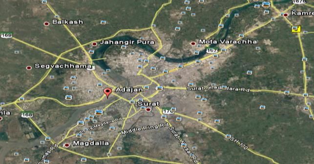
6 Ar Jigna Ashokkumar Vanjara
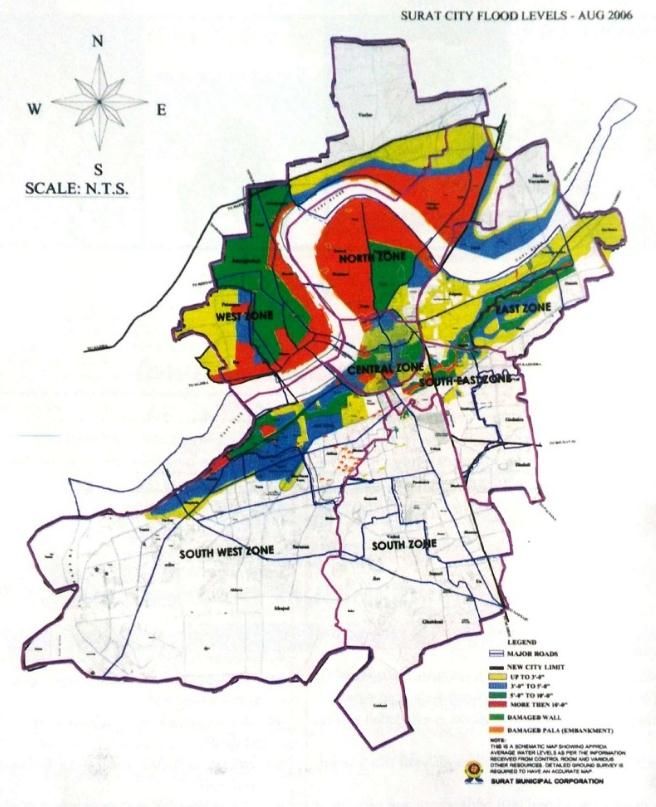
Flood level demarcation of 2006
Source: (Surat Municipal Corporation)
Different zones of Surat city submerged in water.
Source: (G. I. JOSHI, August 2014)
Table Created by Author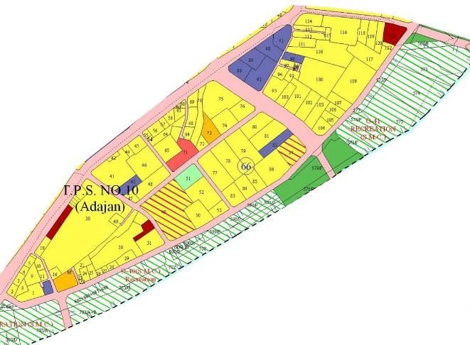
Mitigation of Urban Flooding by using Green Infrastructure in Surat, India 7
3 STUDY AREA
It was not feasible to take all zones of the Surat Municipal Corporation into
consideration; hence Tps no 10 (adajan) of west zone is selected to study as it is the
most flooded area of the city with an average elevation of 8 m from sea level.
Development Plan of West Zone
Yellows: for residential uses such as single-family and town
houses. ·
Browns: for multi-family and high-rise residential·
Reds: retail and commercial uses
Purples: for industrial uses ·
Blues: institutional and public facilities
Greens for recreational uses
Grays for industrial utilities
Tps No: 10 -Adajan
Source: SMC
8                                                        Ar Jigna Ashokkumar Vanjara

The depth of water in west zones area was 2 m to 4 m, which demarcated in flood hazard
map. Out of 23.34 km2 area 23.30 km2 would be under water in West zone if river
reaches to 12 m height near Nehru Bridge. South zone, South-West zone, South-East
zone and Central zone are also low rise area of the city all this zone would not survive
longer for flood of equal frequency as 2006. North and East zone are high rise area of
the city and most of its parts are settled at higher level than 12.5 meter. Accordingly,
these two zones can survive against danger of flood up to some extent compare to
another zone of the city.
The proposed retrofitting of ADAJAN RIVER FRONT RESIDENTIAL AREA (As per
smart city area based proposal) has a low commercial activity and high number of high
rise and single family bungalow as seen in developmental plan and Town development
scheme. Hence, high potential to propose alternative green strategies to mitigate
flooding.

4      STORMWATER MANAGEMENT
Traditionally, flood mitigation infrastructure has relied on cement and concrete in
the form of dams and storm water systems just like Ukai dam in case of Surat, but
with natural disasters ushered in by climate change, traditional defensive approach
to combat flooding may not be enough.
Stormwater Management means to manage surface run-off. It is essential in urban areas
where run-off cannot infiltrate because the surfaces are impermeable. Cities are
replacing the permeable land with impervious surfaces. The problem gets aggravated
by the fact that drains do not have sufficient slope to draw water from surface water and
channelize it.
The storm water during rainy season causes drainage problem and often roads are
damaged by rainfall runoff. This problem is serious in big cities and industries, where
most of the open area is covered by roads or some concrete structures without proper
drainage. The water on roads during rains remains stagnant for hours together due to
poor storm water management and resulting of drainage area hampered.
Storm water harvesting along both the sides of roads with the help of suitable, simple
structures, would not only control storm water hazards in cities, but will enhance ground
water availability 8 to 10 times compared to natural process of rainfall infiltration.
Based on normal rainfall and peak rain fall intensity, the storm water harvesting system
is designed in such a way that 70-80 % runoff of roads and paved area is sent back to
ground water regime after natural filtration process. (Jain)

4.1 Integrating Stormwater Into the Built Environment:
As per resident’s reference guide to stormwater management of Kansas City, Missouri,
the stormwater management is identified by three steps i.e.
    1. Slow it down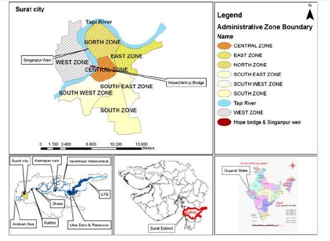
Mitigation of Urban Flooding by using Green Infrastructure in Surat, India                9

      2. Spread it out
      3. Soak it in.
As per the guide, these solutions say, instead of building more (drains, pipes, roads) we
have to build less keeping areas soft and vegetated with native plants, and even
dismantle what we have built. While doing so we have to be careful of not letting the
increased water table affect our basements, tunnels, and building foundations. For
conventional twentieth-century engineering logic, this de-construction method is
counter-intuitive and will be strongly resisted as a solution by most civic authorities,
but it is the global recipe for storm water management, and is being successfully
implemented by enlightened municipal bodies all over the world. The urban flooding
will get worse, much worse, and the only solution is de-construction and establishing
green infrastructure are the major strategy for mitigating urban flooding. So, making it
necessary to implement this at a near zero cost today in a distributed manner by getting
people to effectively create rain gardens, green roof, bios wales, and water storage tanks
or recharge wells. (3)
(3) (A RESIDENT’S REFERENCE GUIDE TO STORMWATER MANAGEMENT,
2015)

5.       ALTERNATIVE TECHNIQUES TO MITIGATE FLOODING.
5.1       Bios wales
Bios wales are an alternative option for concrete gutter and drainage sewer, it is a linear
vegetative channel which help slow down the run-off and percolate into the ground.
As it is linear in nature, its more appropriate for and suitable for parking lots, sidewalks
where there is not steep slope.
Dense vegetation helps to infiltrate run-off effectively, hence native plants are
preferable.
Also, if permeable material like gravel is added below the channel can increase the
storage capacity of run-off.
To ensure that a bio swale continues to operate effectively, it must be inspected
periodically to ensure that the channel is adequately vegetated and that there are no
blockages. (Naturally Resilient Communities)
Bio swales are capable for retrofitting situation and a landscape feature.
Bios wales are generally 3 feet (min) to 7 feet (max) with an ideal slope of 4:1 and
check dams if required for steep slope. It is capable to handle run-off of not more than
6”.
Green Gutters are narrower green street with max width of 3 feet, rate of removing
pollutants is low but is preferable as a buffer between road and sidewalks.it is capable
of handling run-off of not more than 3”.
(Delhi Drainage Master Plan, 2013)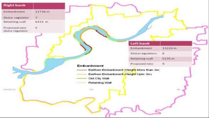
10 Ar Jigna Ashokkumar Vanjara
5.2 Green Roof
Green roof also known as “Living roof” is a thin vegetative cover over a roof to collect,
filter and store rainfall, so as to retain and delay the rain water to end up getting
discharged in stormwater drains. Hence, it prevents waterlogging and eventually
leading to flooding. They typically include a waterproof membrane, drainage and
filtering layers, growing media (soil), irrigation, and plant materials.
Green roof can be incorporated in any building roof top, considering the roof
structures should not have slope of more than 25 percent. Structural Load
consideration is of vital importance to construct green roof specially to retrofit the
existing buildings as they can add tremendous load to the overall structure.
Both the dead load of green roof and live load of people needs to be determined before
implementation. Additional reinforcement may be required to support the green roof
for existing buildings. Studies have estimated payback period from green roof through
energy savings to be anywhere from zero to 20 years. (Naturally Resilient
Communities)
5.3 Permeable Paving:
Permeable surfaces are surfaces which allow water to percolate or travel through their
structure into the underlying ground layer, thereby relieving pressures on traditional
stormwater management system. Permeable pavements are typically designed to handle
as much as 70-80% of annual rainfall.
(Jovian Designs, 2010)
Types of Pavers:
1. Permeable Asphalt (Applicable for sidewalks, low traffic area)
2. Permeable Pavers (Applicable for parks, government common areas)
3. Grass Pavers.
Permeable Surfaces serve as more environmentally conscious, low impact development
materials to rainwater runoff control. Although some surfaces have higher porosities
than others, they all work to restore the in-situ hydrology of a site by reducing runoff,
filtering and treating infiltrating runoff.
6 CASE STUDIES
Significant adaptation examples to urban flooding implemented by different cities
6.1 Rotterdam, Netherlands
Challenges faced to mitigate flooding in Rotterdam were Security, quality, water
storage and lack of public spaces to manage storm water. Hence, measures taken were
To improve water quality and ecology: identify the areas that do not meet theMitigation of Urban Flooding by using Green Infrastructure in Surat, India 11
quality standards (GIS), establish a criteria of wastewater collection,
progressive disconnection of storm water outlets from the drainage system, deal
with storm water by changing the traditional idea of presence of water in cities.
Water storage and lack of space: water squares in low-lying public spaces as
temporary open water storage facilities. The rest of the time is dry place and the
main use is an attractive recreational area with playgrounds, benches, vegetation,
etc...
Expected outcomes
Tackle the water problem –floods and fresh water scarcity– and the lack of public
spaces with a mixed solution: water squares, water, underground storage for sewage
overflow, sponge roofs, and resilience profiles combined with GIS data to set new
targets for ecosystem services. 34.9 m2 of green space per person and higher life
expectancies.
(Rotterdam Waterplan 75-81, 2007)
6.2 Arlington, US
Challenges were to Increase water quality and manage storm water. Accordingly,
measures taken were
Eight rain gardens to reduce storm water volume a prevent sediment and
nutrient pollution.
Eight infiltration trenches under two local avenues to reduce the amount and
speed of runoff water.
A large underground storm water storage and infiltration facility.
Redesign and recovery of a local lake park as a regional level pond, known as
“Como Park”. (Arlington Region Watershed District, 2007)
6.3 Surface Water Management and Urban Green Infrastructure, London
The review discusses about integration of various green infrastructure and storm water
management practices in UK and other international countries with its relevant positive
impact on the city.12 Ar Jigna Ashokkumar Vanjara
The Author highlights Green Stormwater Infrastructure Categories and Credits for
developments or stormwater disconnections in Seattle.
Stage of control Examples of GI related measures
Prevention Good housekeeping on the site and using only licensed
pesticides, herbicides and fertilisers on plants and in garden.
Increasing the permeable area.
Source Green Roofs on building, directing roof runoff on to lawn
areas
Site Grassed Swales, detention /infiltration
Regional Wetland, Retention ponds
The place of GI in the SUDS management train for water quality record
(R . M. Asley, 2010)
6.4 Green Roof as a Storm Water Management Tool in Mumbai by Suchetta
Mathew
The researcher aims to calculate the reduction in volume of run-off quantity by retention
through intensive green roof in retrofitted building of mumbai. 3’ X 3’ green roof model
was made and reading were taken based on different scenario of 80% green roof
available and 50% green roof available. Also highest rainfally recorded for a day and
hourly basis along with the rainfall intensity was noted.
Description 3" Green roof 6" Green roof
Detention per Sqm 20.6 litres 29.44 litres
Retention per Sqm 17.99 litres 21.45 litres
Threshold Rain for 1 Sqm 11.47mm 17.36 mm
Summary of Results from model study
The study showed effectiveness of green roof to mitigate flooding by 12-20%
depending about the roof area available for green roof,the thickness of green roof and
intensity of rain.Also for retroffited building,it is highlighted to propose extensive green
roof with 6” thickness.Mitigation of Urban Flooding by using Green Infrastructure in Surat, India 13
6.5 Permeable Surface Stormwater Management Feasibility Study by Jovian
Designs,London in 2010 was done by Daniel Bittman,Aniruddha
Dhamorikar,Stevan Dixon,Jenna Simpson and Syed Zaidilondon.
Runoff Coefficients for different surface typologies
Surface Runoff Coefficient % Runoff % Infiltration per
per sq. sq.
Conventional Asphalt 0.9 90% 10%
Conventional Concrete 0.9 90% 10%
Conventional roof 0.9 90% 10%
Permeable Asphalt 0.4 40% 60%
Porous Concrete 0.4 40% 60%
PICP 0.25 25% 75%
Extensive Green Roof 0.5 50% 50%
It aims to do comparative analysis and feasibility of implimenting of different types of
pervious pavement along with green roof in different scenario. This is to include the
permeable surfaces in urban design guidelines in the city of london. The study was
based on a baseline case with 20 hectares of city area.Comparison of runoff reduction
for convention and permeable surfaces of Pavement and Green Roofs.
6.6 Using Green Infrastructure to Mitigate Flooding in La Crosse, WI
(United States Environmental Protectin Agency, 2014)By- 2012 green infrastructure
technical assistance program City of La crosse,WI
This report highlights the evaluation of potential of green streets to mitigate flooding
in the Johnson Street Basin.
The project consisted of five steps. First, a detailed EPA Storm Water Management
Model (SWMM) was developed to represent runoff generation and conveyance in the
Johnson Street Basin. Second, three green street designs were selected for further
analysis. One of the selected designs added bio retention to the right -of-way, while two
of the selected designs added permeable pavement. Third, the applicability of each
design within the basin was determined.14 Ar Jigna Ashokkumar Vanjara
Street Assumptions and green infrastructure capability
7 CONCLUSION
Effect on hydrological cycle is the resultant force due to increased impervious surface
area which is a consequence of urbanization. This increased proportion of impervious
surface creates shorter lag times between the arrival of rainfall and consequent high
runoff rates and total flow volume. As a result, municipality’s storm water management
system may be put under increasing pressure in order to compensate for this additionalMitigation of Urban Flooding by using Green Infrastructure in Surat, India 15
volume of runoff. The alternate, non-conventional techniques like green roof,
Permeable Pavement, Bio swales can result in environmental and social benefits and
eventually less pressure on municipality. A Review of the current literature on
permeable surfaces, green roofs and stormwater management approaches and
techniques was conducted. All the research was primarily focused on the typologies,
water retention capacity under different scenario, durability and costing. This review
paper summarizes the current status of the issues related to urban flooding in Surat with
its cause-effect impact to the city and the alternate green techniques in terms of green
infrastructure, Storm water infrastructure adopted all over the world to mitigate the
flooding. Surface Analysis for the site survey with its surface type and percentage along
with its water retention capacity was calculated as baseline. Thereafter, researchers
have created different scenarios for different alternative surface type like permeable
surface and its relevancy to flood reduction run-off. Also, the research updates about
creating a framework on policy making for floodplain areas. Studies have been
conducted at onsite level, neighborhood level and district level with a common principle
of slowing down the run-off in terms of Green Roof, spread it out with bio swales and
soak it underground by pervious pavement. Based on Literature review and site
condition, incorporating Green Roof can work well as selection of study area as TPS
10(Adajan) is a flood plain area and majorly with row houses and residential areas with
very less commercial activities. Green Roof is an effective stormwater measure with
reduction of run-off from 12-20% with respect to thickness to green roof, available total
roof area and rain intensity. Besides Green roof, there are internal lanes(alleys) of 4.5m
to 6 m to access the row houses and bungalows which can be permeable. Hence, scope
of application of different types of permeable pavement can help mitigate
waterlogging and eventually flooding by 40%. Bios wales can handle 6” of runoff and
can work well as the main roads are 45 m wide and secondary roads of 24 and 18 m
wide. Hence, constructing swales with an underdrain can help reduce the impact of
water logging as the soil of Surat is deep black soil with high clay content which has a
poor drainage taking long time to percolate into the groundwater.
REFERENCES
[1] Integrated sustainable urban water network using statistical and analytical
heirarchy process modeling technique: a case study of surat city. (n.d.).
[2] (2015). Retrieved from Surat Municipal Corporation:
https://www.suratmunicipal.gov.in/
[3] A RESIDENT’S REFERENCE GUIDE TO STORMWATER MANAGEMENT.
(2015). Retrieved from Kansas City Water Services:
https://www.kcwaterservices.org/wp-content/uploads/2013/04/KCMO-
Resident-Stormwater-Booklet-2015
[4] Arlington Region Watershed District. (2007). Retrieved from Arlington Pascal
Storm water Improvement Project: http://www.capitolregionwd.org/our-work/
[5] Bhakuni, N. (n.d.). Land Use Planning in Flood Prone. ahmedabad.16 Ar Jigna Ashokkumar Vanjara
[6] Centre for social studies(CSS),Surat and Department of human resources
development(DHRD). (2006). Surat 2006 floods:The citizen' report.
[7] Delhi Drainage Master Plan. (2013). Retrieved from
http://gisserver.civil.iitd.ac.in/delhimp/#
[8] G. I. JOSHI, D. S. (August 2014). Development of Tapi River Flood Water
Surface.
[9] Jain, D. S. (n.d.). STORM WATER MANAGEMENT,ARTIFICIAL RECHARGE
& IMPROVEMENT IN GROUND WATER REGIME. President, Institute of
Water Conservation, Jaipur, India.
[10] Jovian Designs. (2010). Permeable Surface Stormwater Management
Feasibility Study. London.
[11] Naturally Resilient Communities. (n.d.). Retrieved from http://nrcsolutions.org/
[12] R . M. Asley, R. w. (2010). A review of current knowledge. Surface Water
Management and Urban Green Infrastructure, 11-20.
[13] Rotterdam Waterplan 75-81. (2007). 75-81.
[14] Sudhakar BS, A. K. ( 2015). Snyder Unit Hydrograph and GIS for Estimation
of Flood for Un-Gauged.
[15] Sudhakar BS, A. K. (2015). Snyder Unit Hydrograph and GIS for Estimation of
Flood for Un-Gauged Catchments in Lower Tapi Basin,India. Hydrology
Current Research.
[16] Surat Municipal Corporation. (n.d.). Retrieved from
https://www.suratmunicipal.gov.in/
[17] United States Environmental Protectin Agency. (2014). Using Green
Infrastructure to Mitigate Flooding in La Crosse, WI. La Crosse.You can also read