MOZAMBIQUE - Climatelinks
←
→
Page content transcription
If your browser does not render page correctly, please read the page content below
Climate Risk Profile
CLIMATE RISKS TO DEVELOPMENT FOOD SECURITY IN BUREAU
FOR HUMANITARIAN ASSISTANCE GEOGRAPHIES:
MOZAMBIQUE
DOCUMENT OVERVIEW
Food security is essential for advancing sustainable development, strengthening resilience,
improving nutrition, and reducing the need for humanitarian assistance in Mozambique. This
Climate Risk Profile assists the United States Agency for International Development (USAID)/
Mozambique Mission and Bureau for Humanitarian Assistance (BHA) program to better understand
how climate-related stressors threaten Mozambique’s food security, particularly in livelihood zone 5
(MZ05) within Zambezia Province.
This document consists of four main sections:
• Country Overview, which provides context on food insecurity in Mozambique, and the
major climate-related stressors that threaten food security.
• Climate Summary, which describes current and projected changes in climate by mid-
century in Mozambique, Zambezia, and MZ05.
• Livelihoods and Climate in Bureau for Humanitarian Assistance Program Areas,
which describes BHA programming in Mozambique (MZ05 in Zambezia). The section also
includes a table (Table 2) that characterizes each livelihood zone’s climate, crop
production, main sources of food and income, and climate-related hazards and non-climatic
stressors to food security.
• Sector Impacts and Vulnerabilities, which describes the major climate-related risks facing
key sectors that impact food security in Zambezia and MZ05, including:
o Human Health: Disease; Nutrition; Water Supply, Sanitation, and Hygiene (WASH);
and Health Services
o Agriculture
Crop Production
Livestock
Invasive Species
Pesticide Use and Storage
Food Processing and Storage
o Sensitive Ecosystems and Ecosystem Services
November 2020
This document was prepared under Environmental Compliance Support (ECOS) Task Order No. DCHA-014 and is meant to provide a
brief overview of climate risk issues. The key resources at the end of the document provide more in-depth country and sectoral analysis.
The contents of this report do not necessarily reflect the views of USAID.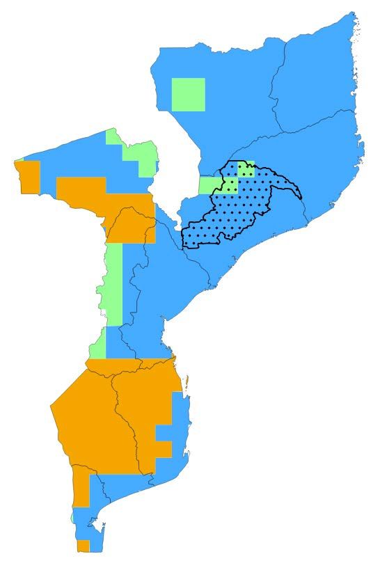
COUNTRY OVERVIEW
Mozambicans experience high rates of chronic food insecurity; approximately one-fourth of the
population is chronically food insecure and nearly half of children younger than age 5 are
chronically malnourished. [1] [2] Chronic malnutrition is most widespread in the northern
provinces—including Zambezia—where populations experience high rates of chronic food
insecurity, and less access to health services, water, sanitation, and education. [3] Malnutrition is
also higher in rural areas relative to urban parts of the country. [4]
Chronic malnutrition and food insecurity in Mozambique are partially driven by several non-climatic
stressors, namely conflict, poverty, constraints to income generation, and inadequate
infrastructure, which result in poor food utilization and diet diversity, poor health and hygiene
practices, a lack of nutritional foods in the diet, poor access to clean water, and poor sanitation and
childcare practices. [4] [5] Tensions and armed conflict remain from the 15-year civil war that
ended in 1992. [4] Roads were destroyed during the civil war and many remain in poor condition.
Poverty is also widespread, with 65 percent of the population living on US$1.90 a day; spikes in
food prices inhibit food access, primarily for poorer households. [3] [4] As of May 2020,
government measures to contain the spread of COVID-19 have resulted in limitations on income
opportunities for poor urban households, and trade restrictions have driven up food prices. [6] [7]
Additionally, several thousand refugees from countries in the surrounding region reside in
Mozambique and depend heavily on humanitarian assistance to meet their food needs. [8]
Mozambique is exposed to various climate-related hazards that worsen food insecurity, including
tropical cyclones, recurring droughts, and coastal and inland flooding (particularly in the Zambezi
Valley). [3] [9] More than 60 percent of the population lives in low-lying coastal areas, where
infrastructure, agriculture, ecosystems, and fisheries are at risk of sea level rise and tropical
cyclones (including flood risks from storm surge). [9] Recent natural hazards, such as 2019
Tropical Cyclones Idai and Kenneth, and 2017 Tropical Cyclone Dineo, have disrupted agricultural
production and livelihoods, and destroyed infrastructure. [4] [8] [9] In 2014–2016, El Niño
contributed to the most severe drought episode in 35 years and reduced food availability by
15 percent. [9]
Climate-related stressors that aggravate food insecurity are projected to become more frequent
and more intense in the future. [9] This includes increased temperatures, more frequent and
intense rainfall events leading to flooding, a shorter rainy season in the north, more frequent and
intense droughts in the central and southern regions, and sea level rise. [9]
Mozambique has several strategic plans laying out potential actions for climate adaptation:
  • 2003 Initial National Communication to the United Nations Framework Convention on
     Climate Change (UNFCCC): Identified the need to strengthen the resilience of agriculture
     and food production to climate impacts. [10]
  • 2012 National Climate Change Adaptation and Mitigation Strategy: Identified strategic
     actions to take for adaptation and climate risk reduction, such as increasing the resilience of
     and capacity to manage natural resources, reducing vulnerability through enhancing
     nutrition, and promoting mechanisms for sustainable development. [11]
  • 2015/2018 Intended/First Nationally Determined Contribution to the UNFCCC: Identified the
     need to increase the resilience of agriculture, livestock, and fisheries; reduce climate risk
     and people’s vulnerability to climate-related diseases; and improve food security. [12]
  • Climate, Environment, and Health Observatory: Developed in 2016, this platform from the
     Ministry of Health monitors and conducts research on climate-sensitive diseases. [13]

                         CLIMATE RISKS IN BHA GEOGRAPHIES: MOZAMBIQUE | 2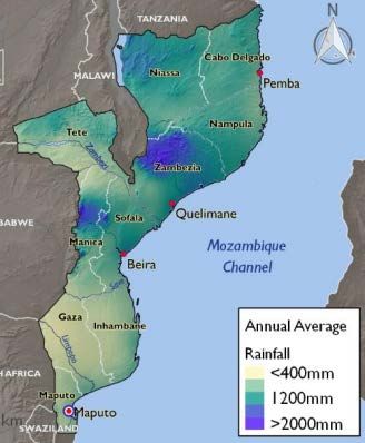
CLIMATE PROJECTIONS
       Warmer temperatures; hotter                     More frequent and intense rains                 More frequent and intense
         and longer heatwaves                                   and flooding                            droughts and dry spells

                                              KEY CLIMATE IMPACTS

                       Agriculture                                            Human Health, Nutrition, and WASH
Greater damage to crops, livestock, and infrastructure from           Reduced availability of health services, clean drinking water
increasingly frequent and intense heavy rains and drought                      Increased risk of waterborne diseases
   Shifts in the timing of planting and growing seasons                  Increased difficulty of accessing medical treatment
    Change in the prevalence of pests and pathogens                                        Reduced nutrition

                        CLIMATE RISKS IN BHA GEOGRAPHIES: MOZAMBIQUE | 3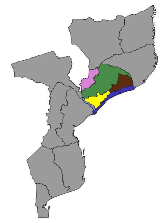
Figure 1. Köppen Geiger climate zones in
CLIMATE SUMMARY                                                            Mozambique. Darkened border with dots signifies
As shown in Figure 1, northern and central                                 MZ05 in Zambezia. Source: The World Bank, HDX,
                                                                           FEWS NET
Mozambique are primarily made up of tropical
savannah with some humid subtropical areas, while
the south mainly contains semi-arid steppe with
some tropical savannah. [9] During El Niño, the
central and southern arid hot steppe regions
expand, and tropical savannah areas along the
northeastern coast turn into arid hot steppe. During
La Niña, the arid hot steppe regions turn into
tropical savannah, and the central parts of
Zambezia Province (including much of livelihood
zone 5 (MZ05)) take on a tropical monsoon climate.
[14]
From April to September, Mozambique’s climate is
cool and dry; nighttime temperatures in the south
can drop below 15°C. [9] From October to March,
the climate is hot and rainy; daytime temperatures
along the northern coast and in the Zambezi Valley
can exceed 35°C. [9] This period also encompasses
a rainy season, which stretches from November to
April, peaking in January/February. [9] [15] The
Intertropical Convergence Zone dictates this
season, bringing monsoonal rains to Mozambique’s
northern and central regions as it migrates
                                                                           Figure 2. Mozambique provinces and average
southward. [9] [15] [16] Tropical cyclones can also                        rainfall. Source: USAID
form in the Indian Ocean and Mozambique Channel,
bringing heavy rains to Mozambique. [9] [17] Both
monsoonal rains and tropical cyclones may lead to
flooding, which can be especially extensive when
coupled with perennial flooding in river basins and
deltas. [16]
El Niño drives substantial interannual variability in
precipitation, bringing droughts 1 every 3 to 4 years,
particularly in the central and southern regions. [3]
[9] Flooding and droughts often occur in the same
year in quick succession, causing severe stress in
multiple sectors throughout the country. [16]
Zambezia is dominated by tropical savannah, while
northwestern parts of the province are classified as
humid subtropical (see Figure 1 above). Northern
parts of the province are cooler relative to southern
parts; average monthly temperatures range from

1
 Throughout this document, “drought” refers to meteorological drought (due to dry weather patterns) and hydrological drought (limited
water supply in surface and groundwater, typically after many months of meteorological drought). Source: NOAA, n.d.

                                CLIMATE RISKS IN BHA GEOGRAPHIES: MOZAMBIQUE | 4
about 16°C to 27°C in the north and 20°C to 30°C in the southern part of the province. [18]
Zambezia is the wettest province in the country; rainfall can reach or exceed 2,000 millimeters in
the northern parts of the province, as shown in Figure 2. [9] [18] The province also experiences the
greatest number of heavy rainfall days of all the provinces, and experiences high flood risk,
particularly in the southern parts of the province. [18] [19] Zambezia’s position downstream from
other rivers also makes it susceptible to flooding that may occur further upstream. Within the
province, dry spells are fairly short and there is minimal interannual variability in their length,
particularly in the northern areas; in the north, the longest average dry spell during the rainy
season lasts fewer than 10 days and has an interannual variability of 2–4 days, while in the south,
the longest average dry spell during the rainy season lasts 15–20 days and has an interannual
variability of 4-6 days. 2 [18] El Niño conditions can lead to slightly increased rainfall (110 percent to
130 percent of normal) in northern areas early in the rainy season (October to December) and
slightly reduced rainfall (60 percent to 80 percent of normal) throughout much of the province late
in the rainy season (January to March). [18] La Niña conditions are linked to slightly increased
rainfall (110 percent to 120 percent of normal), primarily in southwestern parts of the province late
in the rainy season. [14]
Over the past several decades, Mozambique has experienced various changes in climate.
Temperature has increased, particularly in southern Mozambique. [20] Average annual rainfall has
decreased, and droughts have become more frequent (particularly in the south), while flooding has
become more frequent and the proportion of rain falling during heavy rain events has increased. [9]
[20] Coastal regions have experienced a rise in sea levels and more episodic flooding. [9]
Zambezia has experienced these changes as well. Within the province, rainfall has primarily
decreased early in the rainy season (October and November), although rainfall has also decreased
later in the rainy season (February to April) in coastal and northern areas. [20]
In the future, climate change is projected to bring higher temperatures, reduced average annual
rainfall, more frequent and intense droughts, and more frequent and intense heavy rain events, as
well as continued increases in sea level, coastal erosion, and episodic flooding in Mozambique,
including Zambezia and MZ05. [9] [20]
Table 1 summarizes recent climate conditions and trends, as well as projected changes in climate
by mid-century at the country, province, and livelihood zone levels.
Table 1. Country-level, Zambezia, and MZ05 historical and projected climate conditions and trends.
Parameter Observed Trends (over the past several decades) Projected Changes (2050)1
• Mozambique and Zambezia/MZ05: From 1960 to 2019, • Mozambique: Average annual
average annual temperature increased by 0.2°C (0.3°F) per temperature is projected to
Temperature decade. increase by 1.2°C–1.7°C.
• The annual number of hot days (10th percentile) increased by • Zambezia: Average annual
25 days from the 1960s until 2011. [16] temperature is projected to
increase by 1.0°C–1.5°C.
• MZ05: Average annual
temperature is projected to
increase by 1.2°C–1.8°C.
2
“Dry spells” are defined as continuous periods with rainfall of less than 2 mm; the rainy season is considered to occur from December
through February.
CLIMATE RISKS IN BHA GEOGRAPHIES: MOZAMBIQUE | 5Parameter Observed Trends (over the past several decades) Projected Changes (2050)1
• From 2000 to 2014, Zambezia and Sofala experienced more • Increased frequency and
Drought consecutive dry days compared with 1981–1999. [9] intensity of droughts and dry
• From the 1960s to 2018, southern Mozambique experienced spells.
more persistent droughts. [9]
• Increased rainfall in northern areas and reduced rainfall in
southern areas during El Niño years. [18]
• From the 1960s to 2018, the frequency of days with heavy • Increased frequency and
rainfall events increased by 2.6% (25 days per year) per intensity of heavy rainfall
Extreme decade. [16] events and associated
Events • From the 1960s to 2018, coastal regions experienced more flooding.
episodic floods. [9] • Reduced frequency and
• From 1961 to 2001, mean sea level rose by 3 cm. [9] disagreement on changes in
• From 1980 to 2018, tropical cyclones originating in the the intensity of tropical
southern Indian Ocean became less frequent but more cyclones. [24] [25] [26]
intense, and more frequently made landfall. [20] [21] [22] [23]
• Mozambique: From 1960 to 2019, average annual • Mozambique: Average annual
precipitation decreased by 7 mm (~1%) per decade. precipitation is projected to
• Zambezia: From 1960 to 2019, average annual precipitation decrease by 4%–7%, reaching
decreased by 19 mm (~1.5%) per decade. 927–956 mm.
Precipitation • MZ05: From 1960 to 2019, average annual precipitation • Zambezia: Average annual
decreased by 19 mm (~1.5%) per decade. precipitation is projected to
• Rainfall variability increased from the 1960s until 2018, with decrease by 3%–7%, reaching
more rain in the northern regions, more variability in the 1,174–1,220 mm.
central regions, and more drought coupled with episodic • MZ05: Average annual
floods in the southern region. [16] precipitation is projected to
• In 2000–2014, Zambezia and coastal Nampula have received decrease by 5%–8%, reaching
lower average precipitation compared with 1981–1999. [9] 1,150–1,190 mm.
1
Projections are for the 20-year period surrounding 2050 (2040–2059) and are relative to a modeled historical baseline period of 1996–
2015. Projection data represent the mean of the 32 Coupled Model Intercomparison Project Phase 5 (CMIP5) global climate models.
The lower end of the range reflects projections driven by Representative Concentration Pathway (RCP) 4.5, while the upper end of the
range reflects projections driven by RCP 8.5. Projections were retrieved from the Royal Netherlands Meteorological Institute (KNMI)
Climate Explorer.
CLIMATE RISKS IN BHA GEOGRAPHIES: MOZAMBIQUE | 6LIVELIHOODS AND CLIMATE IN BUREAU FOR HUMANITARIAN
ASSISTANCE PROGRAM AREAS
BHA PROGRAMMING
In Mozambique, the USAID Bureau for Humanitarian Assistance program undertakes non-
emergency programming that aims to alleviate the causes of hunger, promote economic and
community development, promote food security, and build resilience to mitigate and prevent food
crises and reduce the need for future emergency assistance. The program has also targeted
longer term development objectives, such as spreading knowledge on better health, hygiene, and
nutrition practices throughout the communities. [27]
BHA Development Food Security Activity investments will sustainably improve nutritional outcomes
for young women and children in MZ05 within Zambezia Province (Figure 3).
Figure 3. FEWS NET livelihood zones in Zambezia.
LIVELIHOOD ZONES IN BHA PROGRAM Source: FEWS.net
AREAS
Zambezia Province contains six livelihood zones
(Figure 3), with the focus of this Climate Risk
Profile being MZ05: Northern Highland with Mixed
Cropping. [28] Most of Zambezia is moderately to
densely populated, with the urban population
growing faster than the rural population, and there
is poor access to services related to health, water,
sanitation, and education, particularly in rural
areas. [28] [29] Households rely heavily on rainfed
agriculture for food and income, both from crop
sales and labor demand. Livestock sales also
provide income, particularly for wealthier
households. [28]
MZ05 is the most productive zone in the northern
region, and all households earn a substantial
portion of their income from selling food and cash
crops, although the average household’s land
holding is small (0.5–2 hectares). [28] In MZ05,
wealth is largely determined by land size, land
area with cash crops, and livestock ownership. [28]
Households earn a significant portion of income
from selling food and cash crops. Poorer households typically grow cassava, maize, sorghum, and
groundnuts to sell and consume, and grow cotton, tobacco, sesame, and cashews to sell. [28]
Poorer households also earn income through selling goats, firewood, and charcoal; working at tea
estates; and cash remittances. [28]
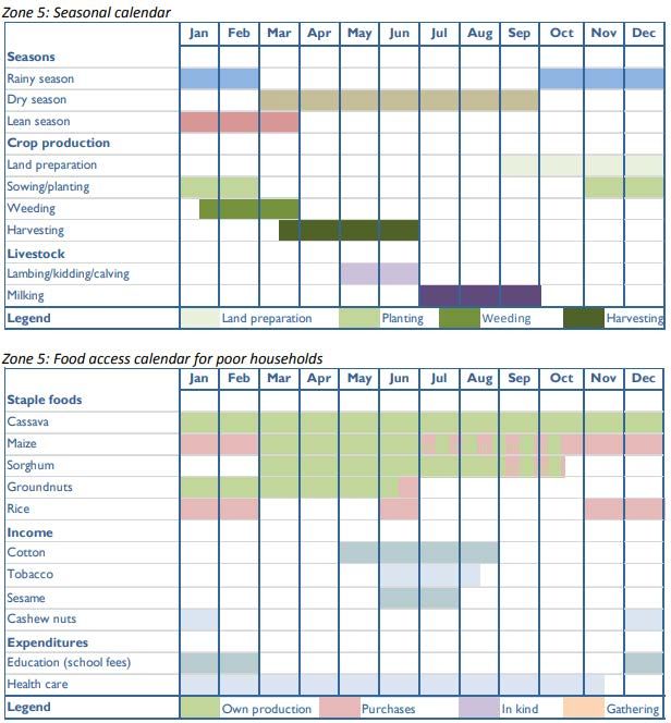
CLIMATE RISKS IN BHA GEOGRAPHIES: MOZAMBIQUE | 7Households in MZ05 can largely Figure 4. MZ05 seasonal calendar for crop and livestock production, and
meet their food needs by food access (i.e., staple food production, income generation, and
expenditures) for poor households.
consuming the crops that they
produce. However, poorer
households purchase maize or rice
to meet their staple food needs,
particularly between October and
February. [28] In low production
years, households typically cope
through agricultural labor and
through selling more livestock,
firewood, and charcoal. [28] Figure
4 depicts the MZ05 seasonal
calendar for crop and livestock
production, and for food access,
income, and expenditures for poorer
households. [28]
Climate hazards that currently pose
the greatest risk to food security in
Zambezia include interannual
rainfall variability and flooding from
tropical cyclones, heavy rainfall, and
riverine flooding, which may result
in the destruction of crops. [28] [30]
Zambezia receives more rainfall
relative to the rest of the country
and drought is infrequent in the province. In MZ05, drought occurs about once every 10 years;
when drought does occur, it can substantially impact agricultural production. [28] While
temperature varies in MZ05, farmers are typically able to sustain average production levels despite
this variation. [28]
Non-climate stressors also threaten food security, such as low producer prices during the harvest
season (April to June), land degradation, and lack of access to markets.
Table 2 describes MZ05’s characteristics and the hazards affecting the zone’s food security. When
developing interventions to address food insecurity risk, it is important to consider how a given
population’s livelihoods and food sources are vulnerable to climate impacts.
CLIMATE RISKS IN BHA GEOGRAPHIES: MOZAMBIQUE | 8Table 2. Livelihood zones, climate, and stressors to food security in the Mozambique BHA program area. Under “sources
of food,” OP = Own produced crops and MP = Market purchases. Source: FEWS NET, 2014
Present Day Main
Livelihood Climate, Terrain,
Zone Description Hazards to Food
Zone and Density
Security
MZ05: Climate modified by Main sources of income for poorer Crops
Northern altitude, which households • Flooding destroying
Highland ranges from 1,000– • Sale of maize, cotton, tobacco, goats, crops and damaging
with Mixed 1,500 meters above agricultural labor, handicrafts, firewood, infrastructure [30]
Cropping sea level; average charcoal, and local brew • Droughts impact
temperature varies • Cash remittances rainfed crop
from 20°C–28°C from Main productive assets for poorer production (1 in every
November through households 10 years, typically
February; moderately •SECTOR IMPACTS AND VULNERABILITIES
HUMAN HEALTH: NUTRITION, WASH, AND HEALTH SERVICES
Vector- and Waterborne Diseases
Vector- and waterborne diseases are responsible for a large number of deaths in Mozambique.
Malaria, which is seasonal in Zambezia and MZ05, is the top cause of death in children under age
5, while diarrheal disease is the fourth leading cause of death overall. [9] In Zambezia, an
estimated 13 percent of children under age 5 have malaria, and an estimated 33 percent have
diarrheal disease. [31] [32]
Climate and weather conditions impact malaria transmission by impacting the lifecycle of parasites
and mosquitos, and the human host. [33] Extreme temperatures can diminish vector survival rates,
although high average minimum temperatures can increase the incidence of malaria, while heavy
rainfall can reduce the incidence of malaria. [33] One study indicates that, historically, the following
will occur:
• A 1-day increase in the number of days above 35°C in a given week leads to a 6 percent
decrease in the incidence of malaria 2 weeks later, while a 1-day increase in the number of
days below 25°C during a given week leads to a 7 percent decrease in malaria 2 weeks
later.
• Each 1°C increase in weekly average minimum temperature leads to a 2 percent increase
in the incident of malaria 4 weeks later.
• Each additional day that receives at least 50 mm of precipitation in a given week leads to
an 11 percent decrease in malaria 4 weeks later.
Climate and weather conditions also impact diarrheal disease, as high temperatures can increase
transmission, and heavy rains and floods can pollute waters with fecal matter. [33] Severe flooding
in 2017 in the Nampula and Cabo Delgado provinces were linked to cholera outbreaks. [9]
Diarrheal disease shows strong seasonality, peaking toward the end of the rainy season (March–
April) in the inland parts of Zambezia (including MZ05). [33] Diarrheal disease cases are lowest
during the cool, dry months (June–August). [33] One study found that, historically, each additional
1°C increase in the hottest day of the week increases diarrheal disease counts by 1 percent that
week, and each additional day on which rainfall reaches or exceeds 1 mm increases diarrheal
disease counts by 1 percent per week for 4 weeks. [33]
Climate change has the potential to increase the incidence of malaria in areas that were previously
unsuitable for the disease (such as higher elevations) within Mozambique. [33] In the northern
region of Mozambique, areas currently of moderate or marginal suitability (1-6 months) will likely
become areas of seasonal (6-9 months) suitability by the 2030s. [33] However, within Zambezia
and MZ05, the risk of malaria is not projected to change. [33] Greater precipitation variability and
the complex relationship between temperature and malaria indicate that transmission is likely to
become more variable and more unpredictable. [9] [33] Climate change may also increase the
incidence of other vector-borne diseases in Mozambique, such as dengue fever and Rift Valley
fever. [34] Future rising temperatures and more frequent heavy rainfall events and flooding may
also increase outbreaks of diarrheal diseases, including cholera outbreaks. [9] One study found
that by mid-century, the diarrheal disease burden is projected to increase by 2 percent due to
increases in temperature and increase by 0.4 percent due to increases in rainfall. [33]
Nutrition
CLIMATE RISKS IN BHA GEOGRAPHIES: MOZAMBIQUE | 10Mozambique and Zambezia have high rates of stunting in children under age 5, with rates at 43
percent and 45 percent, respectively. [4] Malnutrition rates are particularly high in rural areas,
among children whose mothers have no education, and in poorer households, which are especially
numerous in Zambezia due to the province’s poverty rate of 62 percent. [4] [35] Infections such as
HIV and tuberculosis also contribute to malnutrition as these reduce appetite, decrease the body’s
absorption of nutrients, and increase the body’s rate of nutrient use for repairing the body’s
immune system. [4] Aflatoxin, a pathogenic mold that occurs at high levels in crops and soil within
Mozambique, also threatens nutrition. [4]
Climate change impacts on agriculture may reduce crop yields and meat available for
consumption, heightening food insecurity and malnutrition. [9] These impacts include increased
intensity of heavy rains and flooding, increased frequency and intensity of droughts and dry
periods, and higher temperatures, which can affect crop yields, freshwater availability, and
ecosystem productivity. [34] Additionally, more frequent and intense drought and rising
temperatures may increase aflatoxin production and the prevalence of aflatoxin-contaminated
foods. [36] Thus, climate change may disrupt progress on child undernutrition goals; from a 2011
baseline of 12 percent to 20 percent stunting in sub-Saharan African children less than 5 years old,
socioeconomic drivers (such as economic growth and improved livelihoods) may reduce stunting to
7 percent to 17 percent by 2050. However, climate change drivers add uncertainty to this estimate,
increasing it to 9 percent to 22 percent by 2050. [34] Because households in MZ05 largely depend
on rainfed agriculture for food and income, poor households in this livelihood zone are especially
vulnerable to climatic shocks and stressors. [28]
Further details on how climate change will affect agriculture, and thus nutrition, are described in the
Agriculture sections below.
Water Supply, Sanitation, and Hygiene (WASH)
Mozambique faces a lack of access to improved drinking water and sanitation; two-thirds of the
population resides in rural areas, which have more limited access than urban areas and are slower
to implement reform strategies. [9] [37] The civil war in the 1970s–1990s contributed to the large
deficit in access to improved water and sanitation infrastructure. [37] Mozambique also highly
depends on water resources shared with other nations, receiving 50 percent of surface water from
neighbors upstream. [37] There are also large variations in access to water and sanitation within
the country; in 2015, only 3 percent of poor households had access to improved, non-shared
toilets, compared with 76 percent of rich households. [38] Female-headed households (35 percent
of the households in Mozambique), individuals without primary education, and the northern
provinces (including Zambezia) are also among the most adversely affected. [38] Zambezia, in
particular, lacks adequate WASH infrastructure; according to a World Bank study conducted in
2015 [39]:
• Less than 10 percent of poor households (the bottom 40 percent) had access to piped
water.
• Less than 5 percent of poor households had access to improved sanitation.
• More than 80 percent of poor populations practiced open defecation (the highest proportion
in the country).
• Children in this province have among the highest WASH-related burden in the country, with
more than 9,000 disability-adjusted life years per 100,000 children.
More frequent and severe droughts and more variable rainfall are increasingly stressing
Mozambique’s water resources, limiting freshwater availability, particularly for hygiene, as available
CLIMATE RISKS IN BHA GEOGRAPHIES: MOZAMBIQUE | 11water is prioritized for drinking and cooking. [9] [38] Drought also increases the time burden for
households, particularly women and girls, in fetching water; during the 2016 drought in southern
Mozambique, the time spent obtaining water increased from 2–5 hours per day to an average of
10–12 hours per day. [38] Heavy flooding events have compounded the challenges of diminishing
water resources by contaminating the water that is available, resulting in cholera outbreaks. [40]
These effects also have compounding impacts on other sectors, such as a lack of drinking water
resulting in mass deaths of livestock. [41]
Projected rainfall reductions in the upper Zambezia river basin would reduce flows in downstream
parts of the province; according to one study, flows of the Zambezi River may decrease by up to 15
percent. [42] Furthermore, per capita water availability would be reduced to almost 500 cubic
meters per capita per year (one-third of the current status) by 2050, which is far below the water
scarcity threshold of 1,000 cubic meters per year. [42] More frequent and intense heavy rain and
flood events may also increase damage to water infrastructure and increase the contamination of
water sources, further reducing water availability. In coastal parts of Zambezia, saltwater intrusion
into groundwater aquifers may impact the drinking water supply of large coastal cities, and heavy
flooding events will likely continue to intensify, worsening the impact on water supply and
sanitation. [9]
Health Services
Mozambique lacks adequate healthcare facilities and providers. [43] A limited number of trained
health professionals and inadequate funds allocated for healthcare make it difficult to establish a
robust rural healthcare network. [44] In rural areas, barriers to accessing health services include
the distance to health centers and a lack of transportation; only 36 percent of people have access
to a health facility within 30 minutes of their home. [44] [45] Zambezia has relatively high access to
healthcare relative to the other provinces, with much of the province, including MZ05, able to
access healthcare facilities within 30 to 45 minutes.
Extreme events, such as cyclones, heavy rains, and flooding, can damage hospitals and clinics,
and overwhelm roads, making it even more difficult for people to reach health services. When
coupled with other health impacts resulting from flooding, such as cholera outbreaks, this strain on
Mozambique’s health services can be especially disastrous. [40]
Climate change and non-climatic stressors may increase the incidence and severity of flooding,
deteriorating access to health services when many people may need them the most. Additional
climate impacts on health, such as nutrition, disease spread, and sanitation, can compound the
stresses on Mozambique’s health services.
Table 3. Human health: Disease, nutrition, WASH, and health services climate risks.
Climate Risks
Rising temperatures increasing the incidence of malaria, spreading the disease to highland regions, and making
transmission more unpredictable.
Increased flooding raising the risk of diseases such as diarrhea and cholera.
Rising temperatures, increased drought, and changes in rainfall patterns reducing freshwater supply.
Rising sea levels increasing saltwater intrusion into drinking water supply.
Extreme events such as floods and droughts compromising the safety and health of the population and making it
more difficult for them to access health services.
CLIMATE RISKS IN BHA GEOGRAPHIES: MOZAMBIQUE | 12AGRICULTURE
Crop Production
Agriculture makes up more than 25 percent of Mozambique’s gross domestic product (GDP) and
provides livelihoods for 80 percent of the population. [4] Agriculture in Mozambique is
predominantly rainfed and produced by smallholder farmers for subsistence. Most producers are
concentrated in Zambezia, which has the largest land area under agriculture (1 million hectares).
[9] [47] Between 2002 and 2012 in MZ05, the most widely planted crops (with more than 75
percent of households cultivating these) included cassava, maize, and legumes. [29] Other widely
planted crops (with 20 percent to 35 percent of households cultivating these) included rice,
cashews, vegetables and fruits, peanuts, and other cereals and cultures. [29] While very
agriculturally productive, Zambezia faces issues that threaten the agricultural sector, such as a
severe decline in soil fertility. [29]
Climate hazards have historically posed a significant threat to agriculture; from 1996 to 2015, direct
impacts on crop production and supply chains in Mozambique from floods, cyclones, and droughts
resulted in more than US$790 million in agricultural economic losses. [47] The list below further
describes historical climate-related impacts on agricultural production in Mozambique, Zambezia,
and MZ05, where information is available:
• Tropical cyclones, monsoons, and heavy rain threaten farmers’ safety and directly
damage crops and infrastructure through flooding, waterlogging, erosion, and wind.
Several cyclones have hit Mozambique in recent years, such as 2019 Tropical Cyclones
Idai and Kenneth, and 2017 Tropical Cyclone Dineo, which destroyed almost 30,000
hectares of crops and 135,000 cashew and coconut trees. [9] Tropical Cyclone Idai affected
Zambezia the most, displacing 9,600 people in the province and causing heavy rainfall and
flooding. [48] Zambezia is among the provinces that are most exposed to floods and
extreme winds. [19] Within the province, the Zambezi River Valley is especially susceptible
to flooding, particularly flooding caused by tropical cyclones. [49] Meanwhile, inland parts of
the province that are highly agriculturally productive and highly populated (including MZ05)
are generally less exposed to tropical cyclones and flooding. [49]
• Drought and drier rainy seasons decrease agricultural production. Because much of
Mozambique’s (and Zambezia’s) agriculture is rainfed, crops are particularly vulnerable to
droughts and decreased rainfall. El Niño-related drought events have historically occurred
every 3 to 4 years in Mozambique, primarily in the central and southern regions; these
droughts have stressed agricultural production. [9] [19] A 2-year drought from 2015 through
2016, the worst to affect the country in 35 years, reduced food availability by 15 percent. [9]
Historic droughts that occurred in the 1980s and 1990s also resulted in more than 100,000
deaths and disrupted 17 million lives. [16] In Zambezia, drought conditions are less
common as the province typically receives high volumes of rainfall relative to the rest of the
country. [9] [19] Within the province, drought is relatively uncommon in the inland,
agriculturally productive areas (including MZ05), and most common in areas along the
coast and along the northwestern border. [9] [19] [49] Average annual rainfall has declined
for much of the country, including Zambezia. [18] Zambezia has also experienced declines
in rainfall at the beginning and end of the rainy season, shortening this season. [18]
Furthermore, Zambezia suffers from declining soil fertility; thus, while drought does not
pose as great a hazard here as it does in other provinces, reductions in rainfall may
CLIMATE RISKS IN BHA GEOGRAPHIES: MOZAMBIQUE | 13exacerbate the existing issue of soil infertility and harm crop production. [29]
• Crop pests and diseases damage crops; changes in climate may be creating
conditions that are more favorable to pests and disease. Crop pests and diseases,
such as locusts, rodents, and brown streak virus, have damaged agricultural production.
[16] [28] Over the past 10 years, coconut lethal yellowing disease and Oryctes beetle
infestations have decimated coconut trees in Mozambique, as well as in Zambezia and
MZ05; the disease spread is believed to be caused by climate change-driven temperature
increases. [50] [51]
Hazards that currently damage crops and decrease agricultural productivity may become more
frequent and/or intense due to climate change. One study projected that more severe cyclones
would destroy crops and reduce Mozambique’s agricultural GDP by 5 percent to 10 percent by
2050. [49] Over the next 40 years, drought is projected to cause a 2 percent to 4 percent drop in
Mozambique’s yields of major crops (i.e., cassava, sorghum, soybeans, and groundnuts); yields of
drought-sensitive crops like maize are projected to decrease by up to 11 percent. [9]
In Zambezia, more frequent and intense heavy rain events and droughts, higher evapotranspiration
driven by rising temperatures, and rising sea levels threaten crops. Within the province, drought
has the potential to lead to the most substantial economic impacts of all the provinces, with maize
losses estimated to be US$12 million to US$170 million by 2050, depending on drought severity.
[49] More intense wet and dry extremes and rising temperatures may increase the spread of new
and existing pests, such as the fall armyworm and locusts, intensifying threats to crops, particularly
maize and sorghum. [9] [52] Continued sea level rise, coupled with storm surges, may increase
inundation and salinization of agricultural land along the coast and agricultural infrastructure,
particularly during the cyclone season. [16] [43] These hazards may also aggravate saltwater
intrusion into coastal aquifers, harming crops. [16] [43] However, coastal impacts on agriculture
from sea level rise and saltwater intrusion are not applicable to MZ05, which lies farther inland.
Historically, inland areas within Zambezia that are highly agriculturally productive and highly
populated are generally less vulnerable relative to the rest of the country, as they generally receive
sufficient rainfall and face minimal exposure to tropical cyclones and floods. [49] However, MZ05 in
Zambezia has low adaptive capacity to climate change impacts due to widespread poverty, poor
infrastructure, and lack of access to helpful services for farmers. Thus, poor households in this
livelihood zone are highly vulnerable to any climate shocks or stressors that do occur, and could
thus benefit greatly from interventions that increase their resilience and ability to adapt to climate
change.
Table 3 summarizes climate sensitivities and the adaptive characteristics of Zambezia’s staple
crops, while Table 4 summarizes the major climate-related risks facing the agricultural sector.
Table 4. Climate sensitivities and adaptive characteristics of staple crops and crops with the greatest gross production
value in Zambezia and MZ05.
Crop Climate Sensitivities Adaptive Characteristics
Maize • Variable rainfall and rising temperatures • Can tolerate wetter conditions. [16]
may cause yields to decrease 11% by • Improved varieties are available (e.g., drought-
2060 relative to 2018. [9] tolerant matuba, sussuma, changalane). [47]
• Maize is likely to experience some of • Can be mulched with crop residues for vegetal cover.
the greatest reductions in yields due to [47]
climate change. [47]
CLIMATE RISKS IN BHA GEOGRAPHIES: MOZAMBIQUE | 14Crop Climate Sensitivities Adaptive Characteristics
Sorghum • Variable rainfall and rising temperatures • As a small-grained crop, can be used in crop
may cause yields to decrease 2%–4% rotations. [47]
by 2060 relative to 2018. [9]
Cassava • Variable rainfall and rising temperatures • Can tolerate wetter conditions. [16]
may cause yields to decrease 2%–4% • Pest- and disease-resistant varieties are available.
by 2060 relative to 2018. [9] [47]
• Drought-resistant varieties are available. [47]
• Short-cycle varieties are available. [47]
• Benefits from increased temperature. [20]
Rice • Variable rainfall and rising temperatures • Can tolerate wetter conditions, potentially even
may cause yields to decrease. [9] waterlogged areas. [16]
• Land-leveling can increase water-use efficiency. [47]
• Can use direct planting rather than transplanting; this
optimizes soil moisture and water efficiency. [47]
Vegetables • Variable rainfall and rising temperatures • Pest- and disease-resistant varieties are available.
may cause yields to decrease. [9] [47]
Beans • Variable rainfall and rising temperatures • Other crop residues can be used to retain water when
may cause yields to decrease 2%–4% planting beans. [47]
by 2060 relative to 2018. [9]
Table 5. Crop production climate risks.
Climate Risks
Cyclones, heavy rainfall, and flooding can destroy crops and trees, cause erosion, and waterlog low-lying crops.
Changing rainfall patterns causing shifts in growing seasons, particularly in central regions and the Zambezi Valley.
Drought and dry spells resulting in reduced yields or crop failure.
Shortened rainy seasons and increased rainfall variability threatening crops.
Changing temperatures and rainfall patterns spreading crop diseases.
Rising sea levels threaten coastal agriculture.
Cross-cutting.
Livestock
Livestock rearing in Mozambique primarily occurs on a small scale and serves as a key source of
income for many households. [28] In rural areas, about 65 percent of families have chickens, 25
percent own small ruminants (mainly goats), 12 percent own pigs, and 6 percent own cattle, with
men primarily responsible for taking care of all livestock, particularly large species such as cattle.
[38] [61] In Zambezia, better-off households rely on cattle, goats, and/or meat sales as a key
source of income. [28] Poorer households in MZ05 may rely on goat sales as a key source of
income. [28]
Historically, climate hazards have threatened livestock in Mozambique. Drought and low rainfall
reduce drinking water and grazing land for animals; in some cases, farmers cope by killing their
own livestock to reduce competition among animals. [41] Cyclones and flooding can also harm or
kill livestock and destroy their corrals. [41] [62] In Zambezia, livestock have been compromised by
diseases such as Newcastle, swine fever, and trypanosomiasis. [28]
CLIMATE RISKS IN BHA GEOGRAPHIES: MOZAMBIQUE | 15Rising temperatures and more frequent and intense heatwaves may increase livestock water
requirements, heat stress, and the incidence of disease. [9] [61] [63] [64] At the same time,
reductions in average annual rainfall and more frequent and intense drought and dry spells may
limit the water and grazing land available for livestock. [9] These impacts have the potential to
harm livestock health and reduce the quantity and quality of animal products that households are
able to produce. More frequent and intense heavy rain and flood events may also increase
damage to livestock.
These climate stressors may compound non-climate stressors that affect livestock. These include
poor veterinary services, unavailability of breeding stock, limited extension services and knowledge
bases on farms, poor infrastructure, and lack of access to credit that can enable producers to
invest in livestock. [61]
Table 6 summarizes climate change risks to livestock.
Table 6. Livestock climate risks.
Climate Risks
Drought reduces water availability for drinking and may reduce vegetation for grazing.
Increasing temperatures may spread livestock diseases.
Cyclones and flooding killing livestock.
Heatwaves may result in heat stress to livestock.
Invasive Species
Various invasive pests threaten Mozambique’s crops, including the fall armyworm; stem borers
(such as the larger grain borer and spotted stem borer); the blue gum chalcid (which attacks
eucalyptus trees); and sugarcane, cassava, and tomato pests (such as leafminers and mites). [68]
[69] [70] [71] Invasive plants have also been established in Mozambique and have become weeds,
such as the water hyacinth, Kariba weed, and parthenium. [68] [71]
The fall armyworm is one of the most pervasive pests in Mozambique and Zambezia. [69] The
insect feeds on more than 100 crop species, including maize, sorghum, and rice. [69] The fall
armyworm was first detected in Mozambique in early 2017, and its spread is expected to be
irreversible. [69] Because this pest is relatively new, farmers lack adequate resources to mitigate
the problem. [69]
Rising temperatures and changing rainfall patterns may aggravate fall armyworm and other pest
infestations, and cause the pests to spread to new areas. [9] The fall armyworm can reproduce
more often in warmer weather; thus, as temperatures increase, the fall armyworm may multiply
more quickly, intensifying the impact of this pest. [72] More frequent and intense heavy rain and
flood events may also increase opportunities for invasive species to spread, particularly along river
landscapes, by carrying non-native species into new areas through rivers and establishing patches
of habitat suitable for non-native species. [73] For example, in neighboring South Africa, the
parthenium weed became more common and invasive after Tropical Storm Domoina caused
extensive flooding in 1984. [74]
Non-climate stressors may further increase the incidence of invasive pests. Travel and trade
between Mozambique and other countries may bring more potentially harmful invasive species to
Mozambique. [68] In particular, invasive species that have already been introduced in other parts
CLIMATE RISKS IN BHA GEOGRAPHIES: MOZAMBIQUE | 16of Africa, such as maize lethal necrosis disease, may also travel to Mozambique and become
future threats. [71] Because Mozambique’s river systems connect to other countries, invasive
aquatic species may also enter through river flows. [68]
Table 7 summarizes notable climate-related invasive species risks facing Zambezia’s agricultural
sector.
Table 7. Spread of invasive species climate risks.
Climate Risks
Changing temperature and rainfall patterns creating habitats more suitable for invasive species, aiding their
spread.
More frequent flooding increasing opportunities for invasive species to spread.
Pesticide Use and Storage
Pesticide use in Mozambique is low due to the high costs and lack of access to and knowledge
about pesticides, with only about 0.2 British tonne of pesticide used per 1,000 hectares of
agricultural production. [47] From 2002 to 2015 in MZ05, pesticide use ranged from 2 percent to 9
percent of the population, with only 1 percent of the population using herbicides. [29] The
pesticides that are applied are typically used on vegetables, tobacco, and cotton. [75]
As described in the previous section, changes in climate may increase the spread and prevalence
of pests, increasing the need for pest control, including pesticides. However, changes in climate
may compromise pesticide use and heighten the hazards associated with pesticide use. Increasing
temperatures and more frequent and intense heavy rainfall and flood events may also compromise
the integrity of pesticide effectiveness, shorten shelf life, and compromise pesticide storage
facilities. [76] Rising temperatures may increase the risk of crop damage when applying particular
pesticides (e.g., sulfur). [77] More frequent and intense heavy rainfall and flood events may lead to
more runoff carrying pesticide residue, creating human health hazards and damaging ecosystems.
[9]
Non-climate stressors may aggravate the dangers that pesticides pose to human health and the
environment. Historically, there has been a lack of information available about proper pesticide
handling and disposal. [77] Farmers and suppliers are generally unaware of the safeguards
needed to avoid poisoning the people who apply it and the environment, first aid treatment when
mild or severe symptoms occur, proper dosages, and proper transport and storage. [77]
Table 8 summarizes the primary pests that impact Zambezia’s and MZ05’s major crops. Table 9
summarizes the major climate risks with the potential to exacerbate the prevalence of pests, limit
pesticide effectiveness, and increase environmental contamination from the use of pesticides.
Table 8. Major crop pests.
Crop Major Pests
Maize, Sorghum, Rice Fall armyworm
Coconut Oryctes (Rhinoceros) beetle
Boer Beans American cotton bollworm larva
CLIMATE RISKS IN BHA GEOGRAPHIES: MOZAMBIQUE | 17Table 9. This table includes climate risks that may (a) increase the prevalence of pests, (b) reduce the effectiveness of
pesticides, or (c) increase human or environmental health risk from pesticides.
Climate Risks
Rising temperatures and changing rainfall patterns may spread new and existing pests.
Reduced effectiveness and/or shelf life due to climate stressors.
Increased risk of crop damage when applying particular pesticides.
Increased incidence of flooding spreading the environmental risks of pesticide use.
Cross-Cutting.
Food Processing and Storage
Farmers in Mozambique face various post-harvest challenges. Only 20 percent of national roads
are paved, making market access difficult and transport costs more expensive. [47] A lack of
adequate storage facilities also results in high post-harvest losses (about 30 percent of
production), forcing farmers to sell their produce soon after harvest. [82] Parts of MZ05 in
Zambezia benefit slightly from being close to large urban centers in northern Mozambique, as they
are located at the crossroads of roads that head to populated areas such as Quelimane and the
cities of Nampula, Gurué, and Cuamba, and having a rail network that passes through the
livelihood zone. [29] However, Zambezia, for the most part, has one of the lowest Rural
Accessibility Indexes in Mozambique, meaning that families in the province have to travel longer
distances, on average, to reach markets, input vendors, and urban centers, compared with other
provinces. [29]
Flooding limits mobility, particularly during the rainy season when significant portions of the
transportation network become impassable. [9] As a result, many farmers are only able to use
roads during the dry season, resulting in several months of the year when farmers are unable to
sell their crops. [28]
More frequent and intense heavy rain and the resulting flood events may increasingly leave roads
impassable, compromising farmers’ ability to access markets. These stressors may also damage
processing, storage, transportation, and market infrastructure and assets, limiting the volume of
products that farmers are able to bring to market. [9] Increased temperatures may accelerate food
spoilage, increasing time pressure on distribution and reducing outputs. [55]
Table 10 summarizes the risks of climate change on post-harvesting processes in Zambezia.
Table 10. Post-harvest climate risks.
Post-Harvest Component Climate Risks
Processing, Packaging, and Storage • Higher temperatures may accelerate crop spoilage and increase the
growth of fungi that damage seeds. [53]
Transportation and Distribution • More frequent flooding of rural roads that connect crops to markets,
preventing transport. [9]
Cross-Cutting • Cyclones, extreme rain events, and floods can damage infrastructure
and disrupt post-harvest processes.
SENSITIVE ECOSYSTEMS
Mozambique has broad diversity in terrestrial and marine ecosystems that are sensitive to human-
induced changes. The country’s coastal resources, for example, make up a significant portion of its
CLIMATE RISKS IN BHA GEOGRAPHIES: MOZAMBIQUE | 18sensitive ecosystems. Coral reefs, mangroves, estuaries, dunes, inland lagoons, and marine
swamps provide habitats for threatened, ecologically important, and economically valuable
species. [9] [43] Further inland, forests, particularly miombo and mopane, make up about 40
percent of Mozambique’s land. [43] Mozambique also contains at least 17 national reserves and
parks, which make up about 25 percent of its territory. [84]
In a recent mapping of key biodiversity areas (KBAs), 5 of 30 sites were existing or proposed within
Zambezia Province with the potential for the addition of a sixth site. [85] Some sites include
massifs with inselbergs—isolated granite mountain tops that contain endemic species—within
miombo woodlands. [85] [86] Inselbergs also play a key role in watersheds as water captured in
their high forests feeds into rivers. Off the coast of Zambezia lies the Primeiras and Segundas
Archipelago, the largest marine protected area in Africa and a proposed KBA, which contains
diverse coral, mangroves, underwater canyons, seagrass beds, and nesting grounds for
endangered seabirds and sea turtles. [84] [87] The proposed KBA, including the Derre Forest
Reserve, includes several rivers and several significant endemic plant and animal species. [85]
These areas are threatened by deforestation for agricultural production and charcoal, hunting, and
fishing. [85] Zambezia also holds the Gilé National Reserve, which consists of miombo forest that
has faced a history of deforestation, as well as poaching activity. [88] The Zambezi River is the
largest of Mozambique’s rivers, and runs along Zambezia’s southwestern border, feeding into the
Zambezi River Delta near the coast. [89] The 700-square-mile Delta is designated a Wetland of
International Importance under the Ramsar Convention, and is home to the second-largest area of
mangroves in Africa. [89] [90] In addition to the delta’s rich biodiversity, regulating ecosystem
services provide protection from flooding, for example, as well as provisioning services such as
freshwater and fisheries. [91]
Mozambique relies on its ecosystems and the services they provide to support food security and
livelihoods. Coral reefs provide habitats for coastal fisheries, which contribute about 4 percent to
the GDP, employ 95,000 people, and make up half of the nation’s protein intake. [9] [43] These
coral reefs also attract tourists and support livelihoods related to the tourism industry. [9] Forests
contribute 4 percent to the GDP, sustain livelihoods for 11.9 million people, supply 80 percent of
Mozambique’s energy, and contain valuable resources such as timber, medicinal and edible
plants, wild game, and goods for selling and culture. [43]
Climate stressors along with anthropogenic factors play a role in degrading Mozambique’s
ecosystems. Projected increases in the frequency and intensity of heavy rains and drought could
worsen the effects of these events on KBAs, in addition to household food security and livelihoods.
Climate change impacts on coastal resources include increasing sea temperatures and ocean
acidification that harm marine life, sea level rise that increases erosion, and saltwater intrusion that
contaminates freshwater. Droughts, decreased rainfall, increasing temperatures, and heavier
floods can degrade forest resources and worsen other stressors, such as soil erosion and forest
fires. [43] [92]
Table 11. Sensitive ecosystem climate risks.
Climate Risks
More frequent and intense heavy rain and flood events damaging sensitive ecosystems.
Higher sea temperatures and ocean acidification threaten fishing livelihoods and damage marine ecosystems.
Sea level rise and storm surge result in coastal erosion, damaging coastal ecosystems.
CLIMATE RISKS IN BHA GEOGRAPHIES: MOZAMBIQUE | 19Climate Risks
Saline intrusion can kill fish populations in freshwater ecosystems.
Rising temperatures and more frequent and intense droughts and heavy floods degrade forest resources.
More large forest fires due to increasingly dry and hot weather.
CLIMATE RISKS IN BHA GEOGRAPHIES: MOZAMBIQUE | 20KEY RESOURCES
[1] WFP, "Mozambique," World Food Programme (WFP), 2020. [Online]. Available:
https://www.wfp.org/countries/mozambique#:~:text=Chronic%20food%20insecurity%20is%20
now,for%20an%20adequately%20diversified%20diet..
[2] UNICEF, "Nutrition situation in Mozambique," UNICEF, [Online]. Available:
https://www.unicef.org/mozambique/en/nutrition.
[3] FAO, "Nutrition country profiles: Mozambique," [Online]. Available:
http://www.fao.org/ag/AGN/nutrition/moz_en.stm. [Accessed 21 July 2020].
[4] USAID, "Mozambique: Nutrition Profile," 2018.
[5] Human Rights Watch, "The Next One to Die: State Security Force and Renamo Abuses in
Mozambique," 12 January 2018. [Online]. Available:
https://www.hrw.org/report/2018/01/12/next-one-die/state-security-force-and-renamo-abuses-
mozambique. [Accessed 8 September 2020].
[6] FEWS NET, "Southern Africa: Mozambique," 2020. [Online]. Available:
https://fews.net/southern-africa/mozambique. [Accessed 18 June 2020].
[7] FEWS NET, "Mozambique Price Bulletin: February 2020," 2020.
[8] USAID, "Food Assistance Fact Sheet: Mozambique. Updated September 30, 2019," 2019.
[9] USAID, "Climate Risk Profile: Mozambique," 2018.
[10] Mozambique Ministry for Coordination of Environmental Affairs (MICOA), "Mozambique Initial
National Communication under UN Framework Convention on Climate Change," 2003.
[11] Government of Mozambique, "National Climate Change Adaptation and Mitigation Strategy,"
2012.
[12] REPÚBLICA DE MOÇAMBIQUE MINISTÉRIO DA TERRA, AMBIENTE E
DESENVOLVIMENTO RURAL, "Intended Nationally Determined Contribution (INDC) of
Mozambique to the United Nations Framework Convrntion on Climate Change (UNFCCC),"
2015.
[13] Clim-Health Africa, "Mozambique’s Climate, Environment and Health Observatory: The first in
Sub-Saharan Africa," 24 May 2018. [Online]. Available: https://climhealthafrica.org/news-
mozambique-climate-and-health-observatory. [Accessed 8 September 2020].
CLIMATE RISKS IN BHA GEOGRAPHIES: MOZAMBIQUE | 21You can also read