NASA Terrestrial Ecology Program And NASA's Carbon Cycle and Ecosystems Focus Area - Hank Margolis (presented by Josef Kellndorfer)
←
→
Page content transcription
If your browser does not render page correctly, please read the page content below
NASA Terrestrial Ecology Program
                     And
NASA’s Carbon Cycle and Ecosystems Focus Area

                 Hank Margolis
         (presented by Josef Kellndorfer)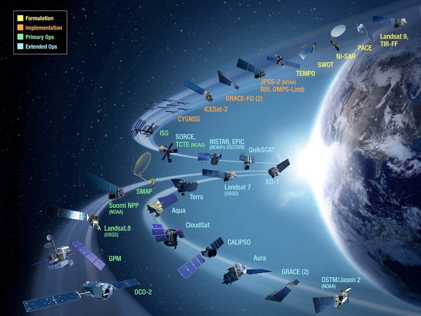
NASA’s Earth Science Division
Research and Analysis         Flight

 Applied Sciences           Technology
Formulation
(Pre)Formulation
Implementation MAIA (~2021)
TROPICS (~2021) Landsat 9
Primary Ops
GEOCarb (~2021) (2020)
Extended Ops PACE (2022)
NISAR (2022)
SWOT (2021)
TEMPO (2018)
JPSS-2 (NOAA)
RBI, OMPS-Limb (2018) InVEST/Cubesats
Sentinel-6A/B (2020, 2025)
GRACE-FO (2) (2018)
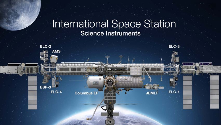
Earth Science Instruments on ISS: MiRaTA (2017)
ICESat-2 (2018)
CATS, (2020) RAVAN (2016)
CYGNSS (2016) IceCube (2017)
LIS, (2017)
SAGE III, (2017) ISS HARP (2017)
SORCE, (2017) NISTAR, EPIC (2019) TEMPEST-D (2018)
TSIS-1, (2018) TCTE (NOAA) (NOAA’S DSCOVR)
ECOSTRESS, (2017) QuikSCAT (2017) RainCube (2018*)
GEDI, (2018) CubeRRT (2018*)
OCO-3, (2018) CIRiS (2018*)
CLARREO-PF, (2020) EO-1
TSIS-2 (2020) Landsat 7 (2017) CIRAS (2018*)
SMAP (>2022) (USGS)
Terra
(>2021) (~2022)
Suomi NPP LMPC (----)
(NOAA) (>2022) Aqua(>2022)
CloudSat (~2018) *Target date, not yet
Landsat 8 manifested
(USGS) (>2022)
CALIPSO (>2022)
GPM (>2022) Aura
(>2022)
GRACE (2)
(2018)
OSTM/Jason 2 (>2022)
(NOAA)
OCO-2
(>2022)
Research & Analysis
~15 Program Managers Covering Earth Sciences
Carbon Cycle & Ecosystems Focus Area

Research and Analysis (R & A)
 Programs:
Biodiversity - Woody Turner
Land Cover and Land Use Change (LCLUC) -
  Garik Gutman
Ocean Biology and Biogeochemistry (OBB) -
  Paula Bontempi
Terrestrial Ecology (TE) – Hank Margolis,
  Kathy Hibbard, Eric Kasischke

Applied Sciences Programs:
Water Resources - Brad Doorn
Ecological Forecasting - Woody Turner

Carbon Cycle & Ecosystems Focus Area

How are ecosystems changing in
 response to environmental change
 and human actions?

How will they change in the future?

How do changes to ecosystems impact
 the other components of the Earth
 system?

How can carbon cycle and ecosystem
 science improve our capacity for
 mitigation and adaption to
 environmental change?

What Do We Do in the NASA
  Terrestrial Ecology (TE) Program?
• NASA Terrestrial Ecology Program, NASA Headquarters.
• TE Program Manager: Hank Margolis
• TE Program Scientists: Kathy Hibbard, Eric Kasischke
• Carbon Cycle and Ecosystems Focus Area

Main Responsibilities
• ABoVE: 2015‐2025
• ORNL‐DAAC
• GEDI (ISS), launch ~December 2018
• Support for:
                        ‐   ICESat‐2:      Autumn 2018 launch date
                        ‐   ASCENDS:                Pre‐formulation
                        ‐    Geo‐Carb               2022 Launch
                        ‐    NISAR                  2022 Launch

• Carbon Monitoring System
• Carbon Cycle Science
• Inter‐Disciplinary Studies
• North American Carbon Program (NACP)
• AVIRIS airborne, EOS‐Land, National Climate Science Assessment
• State of the Carbon Cycle Reports (SOCCR‐2), CEOS Carbon Action Item.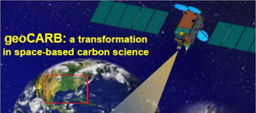
NASA Terrestrial Ecology Approach to
Research
TE Program’s approach to investigating global ecosystems and the
carbon cycle is broad‐based, emphasizing NASA’s unique capabilities
and strengths. NASA Terrestrial Ecology research:
Focuses on utilizing existing satellite data and developing new capabilities for space‐based
global observations of carbon stocks, primary productivity, vegetation composition,
physiology, phenology, successional processes, biodiversity, and the biophysics of remote
sensing these phenomena.
Uses spatial information from remote sensing data to scale up site‐based measurements to
regional and global scales
Analyzes time series remote sensing data records to document and understand variability
and changes over time in ecosystems and carbon cycling
Conducts calibration/validation of satellite data; algorithm development; field campaigns;
process investigations; and data analysis/integration/assimilation
Develops and exercises advanced, quantitative carbon and ecosystems models, data
assimilation models, and coupled land‐ocean‐atmosphere models
Cooperates with NASA Applied Sciences to transition innovative uses and practical benefits
of NASA Earth science data, scientific knowledge, and technology
Cooperates with ESTO to advance the development and demonstration of
technologies that enable improved future capability for the nation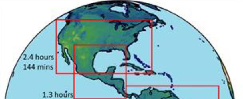
NASA Terrestrial Ecology Approach to
Research
Terrestrial Ecology Elements:
Phenology TE Budget (2016) = ~$15 M / yr
Vegetation structure
Ecosystem services Portfolio (2016) = ~$26 M / yr
Nutrient and biogeochemical cycling
Productivity
Stress
Disturbance and extreme events
Drought impacts and feedbacks
Permafrost dynamics
Disease outbreaks
Ecosystem physiology
Mapping ecosystem properties
Modeling and data assimilation
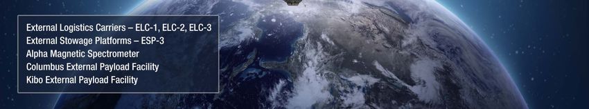
Earth Science Missions and Instruments

Altimetry-FO (Formulation in FY16; Sentinel-6/Jason-CS)

Earth Science Instruments on ISS:
RapidScat, CATS,
LIS, SAGE III (on ISS), TSIS-1, OCO-3,
ECOSTRESS, GEDI,
CLARREO-PF
NASA Terrestrial Ecology Approach to Research
Terrestrial Ecology Recent Research Calls:
Arctic‐Boreal Vulnerability Experiment
(ABoVE‐2 Airborne Campaign)
Interagency Carbon Cycle Science
Carbon Monitoring System (CMS)
Inter‐Disciplinary Sciences (IDS):
• Understanding the Global Sources and Sinks of Methane
• Ecology at Land/Water Interfaces – Human and Environmental
Interfaces
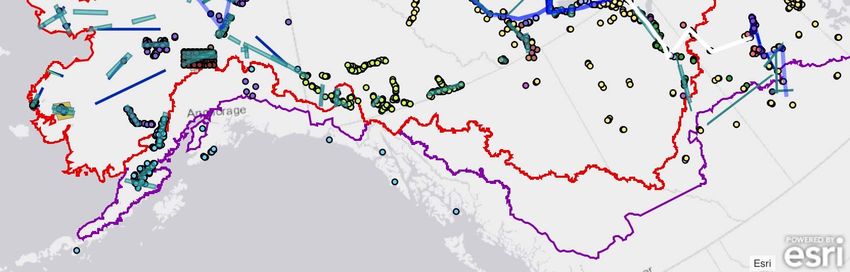
• Partitioning of Carbon Between the Atmosphere and BiosphereArctic-Boreal Vulnerability Experiment (ABoVE) 2017 Flight Lines and Field Plots
2017 ABoVE Airborne Campaign Timeline

Foundational Flights
Jun 2017 Campaign 1A – Spring ALT (UAVSAR, AirMOSS)
Jul 2017   Campaign 1B – Mid‐summer Veg Peak (LVIS, AVIRIS, ASCENDS)
Sept 2017 Campaign 1C – Late Summer ALT (UAVSAR, AirMOSS)

PI-led Flights
Apr – Oct 2017         Carbon Flux Campaigns (Sweeney)
Jun – Sep 2017         CFIS Chlorophyll Fluorescence campaigns (Drewry)
Jun, Aug 2017          AirSWOT campaigns (Smith)
Oct 2017               Early Cold Season ALT (UAVSAR, AirMOSS) (Moghaddam)

                                                                             13
SCALING STRATEGY
LIS (2016)

           SAGE III (6/2016)
                                                           ISERV (2012-2015)
                                                                                  CATS (2015-)
                                                                                HICO (2009-2014)
                                                   RapidSCAT (2014-)              GEDI (2019)
                                                                               ECOSTRESS (2017)
                                                                                  OCO-3 (2018)
                                                                                              15
94th   AMS Meeting, 5 February 2014, Atlanta, GA     CLARREO Pathfinders (CY2019)
GLOBAL ECOSYSTEM
DYNAMICS
INVESTIGATION (GEDI)
- Geodetic-class, light
detection and ranging
(lidar) laser system
- 3 lasers, 10 parallel
tracks of observations.
- lasers fire 242
times/second
- 25-m spot (a footprint).
separated by 25 m
along track
- Across-track distance
of about 600 m
between each of the 10
tracks.
- Expected to produce
about 15 billion cloud-
free observations
during its nominal 24-
Launch: Late 2018
month mission lengthMay 24 2016
MISSION SCIENCE OVERVIEW
CRAIG DOBSON, NISAR PROGRAM SCIENTIST
HANK MARGOLIS, TE&C LEAD
NISAR is a joint program by NASA and the Indian Space Research Organization (ISRO)
• Overall focus is on Earth surface dynamics (solid Earth, ecosystems, cryosphere)
• NASA provides L-band SAR/InSAR, antenna/boom, feed structure, GPS, telecom
• ISRO provides S-band SAR/InSAR, spacecraft, launch
• Expected launch late 2020 or 2021
• 3-yr mission with consumables for 5+
• 12-day repeat, sun-sync, dawn dusk orbit
• All land and ice covered areas imaged at least 2 every 12 days
• 24Tb/day downlink, ASF-DAAC for low level products
• Open data policygeoCARB Selected for EVM-2
Berrien Moore, PI
University of Oklahoma
• First geostationary measurements of CO2, CO, CH4, and Solar Induced Fluorescence; 5-10 km resolution
• Hosted payload on an SES commercial communication satellite (PI-arranged hosting)
• Lockheed Martin Advanced Technology Center (Palo Alto);
18
Colorado State University (Fort Collins); ARC; GSFC; JPLScan Blocks at 85 deg West )rbital Slot
CMS: Congressional Direction (Summary)
Congressional Direction in 2010:
Also included within the funds provided for other mission and data analysis, the conference agreement provides $6,000,000 for
pre-phase A and pilot initiatives for the development of a carbon monitoring system. Any pilot developed shall replicate state and
national carbon and biomass inventory processes that provide statistical precision and accuracy with geospatially explicit
associated attribute data for aggregation at the project, county, state and federal level using a common dataset with complete
      …”pilot initiatives for the development of a carbon monitoring
market transparency, including extraction algorithms and correlation modeling.

Congressional Direction in 2011:
None  system…”
      ...”replicate
Congressional        Direction instate
                                  2012: and national carbon and biomass inventory
The Committee recommends $10,000,000 from within available funds to continue the development of a carbon monitoring system
      processes
initially funded in fiscal yearthat
                                 2010. provide
                                         The Committeestatistical
                                                           expects no less thanprecision             and shall
                                                                                  one-half of this amount       accuracy            with
                                                                                                                     be awarded externally.

      geospatially
Language      in Senate Draft for explicit
                                     2013:         associated attribute data…”
Of the funds provided within the earth science research and analysis activity, the Committee recommends $10,000,000 to
should…”development
continue    efforts for the development of
          be directed towards acquisition,      a sampling,
                                             field prototype
                                          of a carbon                   Monitoring
                                                        monitoring system
                                                              quantification  and development Reporting
                                                                            initially funded in fiscal  year 2010. The and majority of the funds
                                                                                                   of a prototype Monitoring    Reporting and
Verification [MRV] system which can provide transparent data products achieving levels of precision and accuracy required by
      Verification (MRV) system which can provide transparent data to
current   carbon   trading  protocols. The Committee     recognizes that  the  current  orbital and suborbital    platforms
meet these objectives. Therefore, the use of commercial off-the-shelf technologies is recommended as these products could
                                                                                                                            are insufficient
provide robust calibration validation datasets for future NASA missions. Up to 20 percent of these funds should be made available
      products
to international   Reducing  achieving           levels of
                               Emissions from Deforestation    and precision
                                                                    Forest Degradationand   [REDD]accuracy                required
                                                                                                     projects. Furthermore,
deeply disappointed with the lack of progress that NASA has made on this initiative thus far within the agency. Therefore, it
                                                                                                                               the Committee byis
directs that the above funds shall be competitively awarded within 120 days of enactment of this act.
      current carbon trading protocols….”
Congressional Direction in 2014:
Carbon...”[development                     of]within
           Monitoring- Of the funds provided      a plan…incorporating
                                                        the Earth Science research and analysis   such activity,athe[MRV]
                                                                                                                      Committee system
                                                                                                                                  recommends
$10,000,000 to continue efforts for the development of a carbon monitoring system. The majority of the funds should be directed
towardinto its operating plan and long-term budget projection…” [MRV]
          acquisition,  field sampling, quantification,  and development    of a prototype   Monitoring   Reporting    and Verification
system which can provide transparent data products achieving levels of precision and accuracy required by current carbon trading
protocols. The Committee is concerned that NASA has not established a program of record around the development of MRV
system, and therefore expects a plan from NASA not later than 90 days after enactment of this act incorporating such a system
into its operating plan and long-term budget projection. The Committee recognizes that the current orbital and suborbital platforms
are insufficient to meet these objectives. Therefore, the use of commercial off-the-shelf technologies is recommended as these
products could provide robust calibration validation datasets for future NASA missions.
CMS Application Readiness Levels (ARLs)
DSCOVR – EPIC (Lunar Transit movie)
DSCOVR – EPIC (Solar Eclipse, 21-08-2017)
You can also read