National Report of Greece to EUREF 2021
←
→
Page content transcription
If your browser does not render page correctly, please read the page content below
National Report of Greece to EUREF 2021
                               M. Gianniou, D. Mastoris, E. Mitropoulou,
                               Hellenic Cadastre, Geodetic Department
                               Mesogion Ave. 288, 15562 Athens, Greece

1. Introduction

   During the last months the main activities of the Hellenic Cadastre related to EUREF focused on
the upgrade of the HEllenic POsitioning System (HEPOS) and the estimation of permanent
displacements caused by two strong earthquakes. This report describes the details of upgrading
HEPOS to full GNSS (Global Navigation Satellite Systems) and the displacements of HEPOS
stations induced by:
- The 2020 Samos, east Aegean Sea earthquake
- The 2021 Elassona, Thessaly, central Greece earthquake.

2. Upgrade of HEPOS to full GNSS
2.1 Preface

   The HEllenic POsitioning System was established in 2007 as part of the project "Information
Society" co-funded by the European Regional Development Fund. In 2008 it started its initial
operation and was used by cadastral contractors, whereas in 2009 it was made available to the
community. It consists of 98 reference stations, and supports network-RTK (VRS, MAC, FKP) and
post-processing services (RINEX & VRINEX) (Gianniou, 2009). HEPOS is the official system for
the cadastral surveys in Greece. The coordinates of its stations are expressed in the European
Terrestrial Reference System 1989 (ETRS89) and constitute the official realization of ETRS89 in
Greece approved by EUREF (EUREF, 2010). HEPOS is at the time of writing serving more than
1200 users (more than 1700 user licences). In 2020, using national funds, HEPOS was upgraded to
full GNSS as described in the following.

2.2 Project details

   The project started in 2019 and has two main components: a) the upgrade of the network to full
GNSS and b) the maintenance of the network for 3.5 years. The upgrade has been concluded in
2020. The maintenance is being supplied from the beginning of the project and will last until the
end of the project to ensure unproblematic completion of the extensive cadastral survey projects that
are under deployment in Greece. Other parts of the project include testing of the upgraded system,
training of the personnel and technical support, as described in the following sections. The
contractual price for the complete project was 2 M€.

2.3 System upgrade

   At the time of designing and establishing HEPOS the vast majority of the European RTK-
networks were supporting solely GPS. The next evolution step was the combined use of GPS and
GLONASS. In the latest years there was a significant progress in the deployment of the
constellations of Galileo and BEIDOU. Thus, HEPOS has been upgraded, in order to support all
four GNSS, i.e. GPS, GLONASS, Galileo and BEIDOU as well as SBAS (Satellite Based
Augmentation Systems). The previously installed Trimble NetRS receivers were replaced by

                      EUREF Annual Symposium, May 30 - June 1 2021, Ljubljana, Slovenia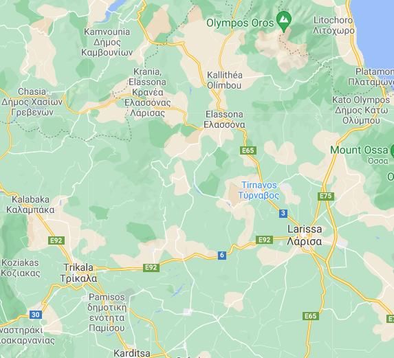
Trimble Alloy receivers as shown in Table 1. The new receivers are capable of tracking all signals
transmitted by the GNSS satellites (Table 2).

                          Table 1. Upgrade of HEPOS receivers and antennae
                         Initial network                          After Upgrade
Receivers                Trimble NetRS                            Trimble Alloy
 Antennae    Trimble Zephyr geodetic with dome           Trimble Zephyr geodetic model 3 with dome
                   IGS code: TRM41249.00   TZGD                  IGS code: TRM115000.00   TZGD

                    Table 2. GNNS signal tracked by the upgraded HEPOS receivers
                      Satellite system                  Signals tracked
                             GPS                     L1, L2, L2C, L5, L1C
                          GLONASS                              G1, G2, G3
                            Galileo                  E1, E5a, E5b, E5alt-BOC, E6
                           BEIDOU                              B1, B2, B3
                   EGNOS-WAAS-GAGAN                            L1C/A, L5

   Besides the upgrade of the GNSS equipment at the reference stations, the software in the Control
Centre was also upgraded to support full GNSS operation. The old software Trimble GPSNet was
replaced by Trimble PIVOT Platform. Selected features of the software are outlined in Table 3. The
new software is hosted in powerful rack servers (Dell PowerEdge 540). Redundant servers are used,
in order to minimize the impact of a possible hardware failure.

           Table 3. Selected features of the new software in the Control Centre of HEPOS
    Item                                          Software capabilities
    Full GNSS             RTCM 3.2 and MSM 3-7 are supported for full GNSS RTK.

    Modelling               Individual station velocities are supported.
    Access plans            Access (contract) plans are customizable.
    GDPR                    The software supports the necessary tools to comply with GDPR
                            (web site, passwords management etc.).
    User accounts           Users are able to change personal data, reset password, view
                            subscription information and usage details.

2.4 New services

   Besides the full GNSS capability, the upgrade of HEPOS offers also new functionalities that
registered users can benefit. Now, users have access to their personal and contract details. They can
change personal data, reset their password and get information regarding their subscriptions (start
and expiration dates, used and remaining time of the service etc.). Further to that, the users can
retrieve detailed information of the usage they make, in terms of connection times, used services,
duration etc. Also, the users, by logging into the system can have various information, like station
status, ionospheric index I95, quality indexes IRIM/GRIM and notices issued by the system
operators.

                     EUREF Annual Symposium, May 30 - June 1 2021, Ljubljana, Slovenia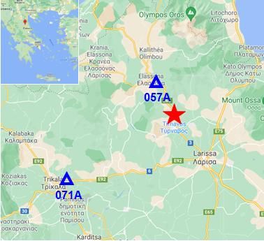
2.5 Other project components

   After the completion of the upgrade, a testing phase took place. During the testing phase,
extensive checks were performed to verify the satisfaction of all the technical specifications of the
complete system as well as the backwards compatibility of the coordinates.
   Another important project component was the training of the network operators on elements of
the operation and administration of the upgraded system. The training program was provided in two
phases. The aim of the first part of training was for the employees to acquire the necessary basic
knowledge in order to be able to perform the basic management and operation of the system. The
second part of the training was provided after the completion of the upgrade and was focused on
more specialized topics of the fully operating upgraded system.
   It is important to mention that apart from the upgrade of the HEPOS, the project includes also
the maintenance and technical support for the whole system for 3.5 years.

2.6 Challenges faced

   The upgrade of HEPOS was conducted in the presence of several challenges both technical and
practical. The duration of the upgrade was limited to nine months which is considered short taking
into account the perplexity of the venture and the dispersion of the localities to visit. Another
challenging parameter of the project was the necessity to run in absolute synchronization with the
renewal of the telecommunication network - a separate project that entirely changed the
telecommunication infrastructure of the system. Perhaps, the greatest challenge was that the
upgrade procedure had to take place in a way that wouldn’t interfere with the operation of the
system itself. The achieved downtime was practically very close to zero in almost all cases, thus
making the whole venture unseen to the users and allowing all works, cadastral projects included, to
run uninterrupted. Another great challenge was that during upgrade strict measures due to Covid-19
conditions took place. All inter-prefectural transportations were practically prohibited so the
deployment of the project suddenly halted. Special permission from the Hellenic State was needed
in order to continue. Next to the above challenges, there also was the requirement to keep the
coordinates that would be provided by the upgraded system backward compatible with the ones
provided before the upgrade.

3. Displacements due to Earthquakes
   In the framework of operating HEPOS and maintaining the reference frame, geological
phenomena that lead to coordinate changes are being investigated. In this context the effects of two
strong earthquakes that occurred during the last months have been studied. In the following the
estimated permanent displacements caused by the 2020 Samos, east Aegean Sea earthquake and the
2021 Elassona, Central Greece earthquake are presented.

3.1 The 2020 Samos, east Aegean Sea earthquake

   On October 30, 2020 a strong earthquake occurred in the northern offshore area of Samos Island,
Greece. Estimations for the moment Magnitude Mw and the focal depth range from 6.9 to 7.0 and
from 6 km to 21 km, respectively. The event triggered a powerful tsunami with 2 m recorded
inundation in the northern part of the Island (Triantafyllou et al., 2021; Papadimitriou et el., 2020).
Moreover, the event caused significant horizontal co-seismic deformations in the order of tens of
centimeters mainly in the northern part of Samos. In order to investigate the impact of the

                    EUREF Annual Symposium, May 30 - June 1 2021, Ljubljana, Slovenia
earthquake on the reference stations of HEPOS we processed the data from three HEPOS stations
located at distances between 25 and 75 km from the epicenter of the earthquake. Their locations as
well as the epicenter of the earthquake are depicted in Fig. 1.
The data processing was done using the Precise Point Positioning (PPP) method (Zumberge et al.
1997; Héroux and Kouba, 2001). We chose to use this approach rather than geodetic relative
positioning, in order to avoid biased displacement estimation as a result of eventual displacements
of the nearby stations that would be used as reference in the formation of the baselines. The PPP
computations were made using the CSRS-PPP software. Dual frequency phase observations were
used together with final precise orbits (sp3 files) and clocks (clk files) (Kouba, 2003). The
processing interval was 30s and the elevation mask 7.5o.
Daily solutions were computed by processing the observations in PPP static mode. For each
station the time period from October 16 to November 13, 2020 was processed, which corresponds
to 14 days before the event and 14 days after the event. Fig. 2-4 give the time-series of the
estimated Easting and Northing coordinates and the height of station 093A located on the island of
Samos. The shifts in both coordinates are obvious and in the local ENU frame amount 2.0 cm in
East and -15.4 cm in North. Moreover, an uplift of the station is clear which amounts 2.3 cm. The
estimated slip vectors for stations 093A, 095A and 094A are depicted in Fig. 5 and correspond to
horizontal displacements of 15.5 cm, 2.6 cm and 1.9 cm, respectively.
Fig. 1 Epicenter of the 2020 Samos earthquake (red star) and locations
of the three nearby HEPOS stations (red triangles).
485305.24
485305.23
Easting (m)
485305.22
485305.21
485305.20
15-Oct 20-Oct 25-Oct 30-Oct 4-Nov 9-Nov 14-Nov
Date
Fig. 2 Time-series of Easting of station 093A (the vertical dashed line indicates the day of the earthquake).
EUREF Annual Symposium, May 30 - June 1 2021, Ljubljana, Slovenia4169387.50
4169387.48
Northing (m)
4169387.46
4169387.44
4169387.42
4169387.40
4169387.38
4169387.36
4169387.34
15-Oct 20-Oct 25-Oct 30-Oct 4-Nov 9-Nov 14-Nov
Date
Fig. 3 Time-series of Northing of station 093A (the vertical dashed line indicates the day of the earthquake).
282.91
282.90
Height (m)
282.89
282.88
282.87
15-Oct 20-Oct 25-Oct 30-Oct 4-Nov 9-Nov 14-Nov
Date
Fig. 4 Time-series of height of station 093A (the vertical dashed line indicates the day of the earthquake).
095A
093A
094A
10 cm
Fig. 5 Estimated static horizontal displacements at nearby HEPOS reference stations. The epicenter of the
earthquake is marked by red star.
In the northern part of the Island of Samos displacements of ~37 cm were reported.
Deformations of this magnitude consist a major challenge for the maintenance of the reference
frame. In order to handle efficiently such displacements a detailed deformation model should be
available as soon as possible after the earthquake. However, for complicated events like the 2020
Samos earthquake it usually takes some time until detailed and reliable deformation models are
computed and published.
EUREF Annual Symposium, May 30 - June 1 2021, Ljubljana, Slovenia3.2 The 2021 Elassona, Thessaly, central Greece earthquake
On March 3 and 4, 2021 two strong earthquakes stroke in Thessaly, central Greece, close to the
town of Elassona. The events had moment Magnitudes Mw=6.3 and Mw=6.1 and their estimated
focal depths vary from 4 to 19 km and from 7 to 17 km, respectively (Lekkas et al., 2021). The
events caused severe damages and noticeable horizontal deformations. In order to investigate the
impact of the earthquakes on the reference stations of HEPOS we processed the data from two
HEPOS stations located at distances of 13 and 38 km from the epicenter of the first event (Fig. 6).
Fig. 6 Epicentral area of the March 3 & 4, 2021 earthquakes (red star) and nearby HEPOS stations (blue triangles).
The data processing was done using PPP following the data processing strategy described in
section 3.1. Daily solutions were computed for each station for the time period February 17 to
March 17, 2021, which corresponds to 14 days before the events and 14 days after the events. Fig.
7-9 give the time-series of the estimated Easting and Northing coordinates and the height of station
057A. The shifts in both coordinates are obvious and in the local ENU frame amount 2.8 cm in the
East and 4.7 cm in the North. Moreover, an uplift of the station is clear which amounts 2.0 cm. The
slip vectors estimated for stations 057A and 071A (Fig. 10) correspond to horizontal displacements
of 5.5 and 2.1 cm respectively.
605048.16
605048.15
Easting (m)
605048.14
605048.13
605048.12
605048.11
16-Feb 21-Feb 26-Feb 3-Mar 8-Mar 13-Mar 18-Mar
Date
Fig. 7 Time-series of Easting of station 057A (the vertical dashed lines indicate the days of the earthquakes).
EUREF Annual Symposium, May 30 - June 1 2021, Ljubljana, Slovenia4415059.93
4415059.92
4415059.91
Northing (m)
4415059.90
4415059.89
4415059.88
4415059.87
4415059.86
16-Feb 21-Feb 26-Feb 3-Mar 8-Mar 13-Mar 18-Mar
Date
Fig. 8 Time-series of Northing of station 057A (the vertical dashed lines indicate the days of the earthquakes).
346.42
346.41
346.40
Height (m)
346.39
346.38
346.37
16-Feb 21-Feb 26-Feb 3-Mar 8-Mar 13-Mar 18-Mar
Date
Fig. 9 Time-series of height of station 057A (the vertical dashed lines indicate the days of the earthquakes).
057A
071A
2 cm
Fig. 10 Estimated static horizontal displacements at nearby HEPOS reference stations.
The epicentral area of the earthquakes is marked by red star.
Acknowledgments
The establishment of HEPOS was co-funded by the European Regional Development Fund in the
framework of the Operational Program “Information Society”.
EUREF Annual Symposium, May 30 - June 1 2021, Ljubljana, SloveniaReferences
Gianniou, M. (2009), National Report of Greece to EUREF 2009, EUREF 2009 Symposium, May
27-30 2009, Florence, Italy.
EUREF (2010), Resolutions of the EUREF Symposium in Gävle, June 2-6, 2010.
Héroux, P. and J. Kouba (2001), GPS precise point positioning using IGS orbit products, Phys.
Chem. Earth Part A, 26(6–8), 573–578, doi:10.1016/S1464-1895(01)00103-X.
Kouba, J. (2003), Measuring seismic waves induced by large earthquakes with GPS, Stud. Geophys.
Geod. 47(4), 741–755.
Lekkas et al. (2021), The early March 2021 Thessaly earthquake sequence, Newsletter of
Environmental, Disaster, and Crises Management Strategies, Issue No.22, March 2021, National
and Kapodistrian University of Athens, ISSN 2653-9454.
Papadimitriou, P., Kapetanidis, V., Karakonstantis, A., Spingos, I., Kassaras, I., Sakkas, V.,
Kouskouna, V., Karatzetzou, A., Pavlou, K., Kaviris, G., & Voulgaris, N. (2020). First Results on
the Mw=6.9 Samos Earthquake of 30 October 2020. Bulletin of the Geological Society of Greece,
56(1), 251-279. https://doi.org/10.12681/bgsg.25359.
Triantafyllou, I., Gogou, M., Mavroulis, S., Lekkas, E., Papadopoulos, G.A., Thravalos, M. (2021).
The Tsunami Caused by the 30 October 2020 Samos (Aegean Sea) Mw7.0 Earthquake:
Hydrodynamic Features, Source Properties and Impact Assessment from Post-Event Field Survey
and Video Records, J. Mar. Sci. Eng. 2021, 9, 68. https://doi.org/10.3390/jmse9010068.
Zumberge, J. F., M. B. Heflin, D. C. Jefferson, M. M. Watkins and F. H. Webb (1997), Precise
point positioning for the efficient and robust analysis of GPS data from large networks, J. Geophys.
Res., 102(B3), 5005–5017, doi:10.1029/96JB03860.
EUREF Annual Symposium, May 30 - June 1 2021, Ljubljana, SloveniaYou can also read