Network of Streets and Shops in the Upper Town of Lugdunum between the 1st Century BC
←
→
Page content transcription
If your browser does not render page correctly, please read the page content below
Network of Streets and Shops in the Upper Town of
Lugdunum between the 1st Century BC
and the 3rd Century AD
Marine Lépée1
Introduction
The colony of Lyon, founded in 43 BC and promoted to the capital of the province of
Gallia Lugdunensis under Augustus, was a central trading place in Gaul and a real
economic hub at the interface between Gallia Narbonensis and the more northern
territories. It took advantage of the major distribution route constituted by the river
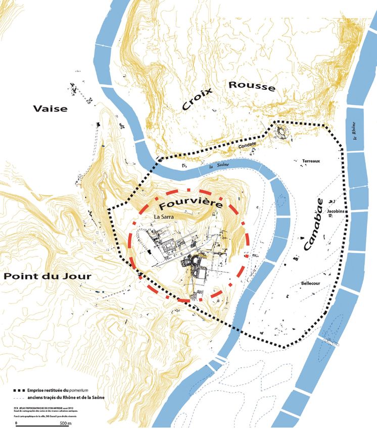
Rhône. The settlement was established on the hill of Fourvière, overlooking the river
Saône. The plateau of the Sarra, at the top of the hill, contained the settlements. That’s
where the economic landscape and the networks of streets are best known (fig. 1).
A particular interest for Lyon’s economic premises as a framework for the retail
trade was shown by the academic work conducted by Marine Lépée,2 and continued in
a thesis started in September 2017 at the scale of the Rhône Valley. An inventory of the
shops in the upper town, resulting from ancient or more recent excavations, was the
basis of an architectural, topographical, and small finds analysis of these premises.
A typological grid served as a basis to recognize these places. This typology was
partly based on the categories mentioned by Eric Delaval in his thesis,3 and by Benjamin
Clément in his study of domestic architecture in Lyon.4 It defines the premises both
by the way they organized themselves and by the way they were related to the
neighbouring areas. It thus distinguishes between premises associated with residential
units (“bloc-boutique” and corner complexes) and premises operating independently
(i.e. independent complexes with or without a floor). Significant interactions with the
urban network have been recognized for these different places.
The Particularities of Lyon
The Major Urban Networks
The urban landscape of Lyon had particularities that need to be quickly presented here.
The network of streets on the hill of Fourvière had to adapt to a difficult topography,
marked by steep slopes. This configuration of the landscape partly explained the
coexistence of several grids oriented along different axes. They also reflected different
chronological realities (fig. 2).5
The network A appeared from the colonial settlement and was centred on the “rue
de l’Océan”. This grid developed on the whole plateau of Fourvière and on its southern
slope until the level of the Cybèle district, where a second network was highlighted.
Published in: Grégory Mainet – Thomas Morard (Eds.), Roman Street and Urban Economy, Panel 8.12, Archaeology and Economy
in the Ancient World 47 (Heidelberg, Propylaeum 2021) 77–90. DOI: https://doi.org/10.11588/propylaeum.705.c10630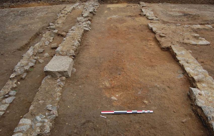
78                                  Marine Lépée

Fig. 1: The heart of the upper town: the plateau of the Sarra, on the top of the hill of
                                      Fourvière.

The network B developed on the eastern slope of the hill between the “rue des Farges”
and the “rue Cléberg”, at least from the beginning of the 1st century AD or earlier. A
third network, the network C, was circumscribed to the southern edge of the Fourvière
terrace.6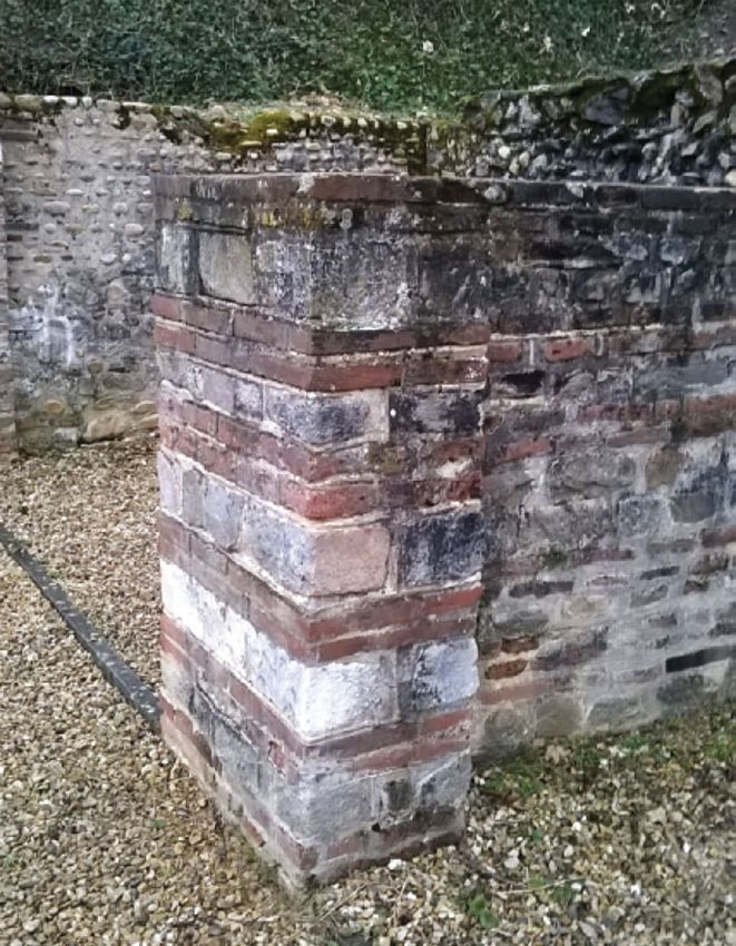
Network of Streets and Shops in the Upper Town of Lugdunum                  79

           Fig. 2: The major urban networks and shops in the upper town.

   These three major street grids coexisted during the entire period the upper city was
occupied. They delimited blocks of square shape at the time the colony was founded,
when the primitive urban nucleus occupied only the top part of the hill. They then took
a rectangular shape.7 The shops were particularly recognized within the network A.
   All the streets bordered by shops in the upper city had a central roadway flanked by
pavements. These were generally separated from the roadway by a ditch that acted as a
gutter and was usually sheltered under porticoes. Their total width varied between 30,
40 or more exceptionally 60 feet. The first plank gutters appeared from the Augustan
period, while masonry drainage and street paving became widespread from the middle
of the 1st century AD (fig. 3).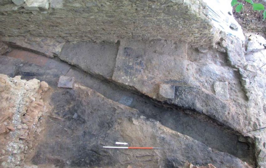
80                                       Marine Lépée

                               Fig. 3: The street of the theatre.

   In Lyon, the porticoes were made of wooden posts set on masonry blocks, which are
the main remains that testify today to the existence of these porticoes. From Claudius
onwards, the wooden posts of the porticoes were often replaced by masonry pillars to
contribute to the vast architectural program implemented since the beginning of the
century in the upper town (fig. 4). The porticoes in Lyon generally had a width of 3 m,
which seemed to be the norm.8

A Difficult Topography Marked by Steep Slopes: Terraced Constructions
In Lyon, the slope of the hill of Fourvière obliged the network of streets, the residential blocks,
as well as the artisanal and commercial areas to be organized in successive terraces. Thus,
differences in levels conditioned the location of shops and their relations with adjoining
domestic space. The example of the Rue des Farges speaks for itself: commercial premises
developed below a domus and on the edge of a place on a much lower terrace.
    As a result of this terraced topography, many shops in the corpus leaned against retaining
walls. This could help to give an autonomous aspect to the economic complex by separating
it from other buildings or isolating it from an adjoining domus. This installation on the slopes
of the hill, beyond a simple technical response to a difficult topography, also proposed a
visual game. It allowed the domus and their shops to be monumentalized, which contributed
to make them visible from the quays of the Saône below.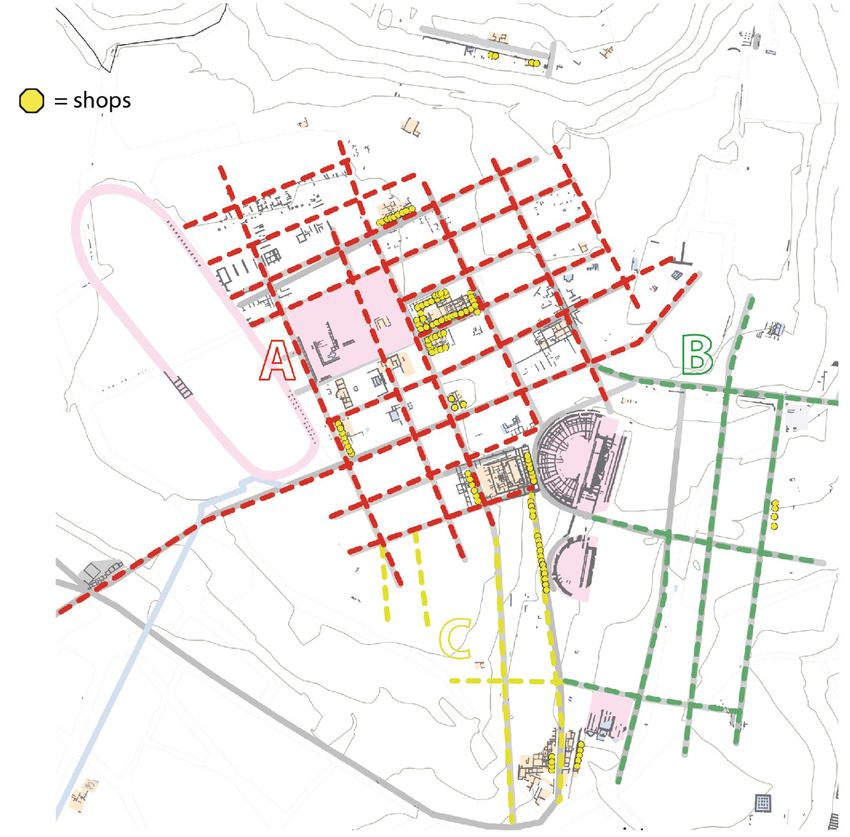
Network of Streets and Shops in the Upper Town of Lugdunum                      81

           Fig. 4: The street of “la Stèle de Rufus” and the masonry supports.

                           Focus on Two Particular Cases

We will focus more particularly on two recent excavations in Lyon which have led to
discover particularly well-preserved economic complexes (Silvino 2011 and Clément
2014). These were associated with residential units and were included in their relationship
with the urban plot. They offered a detailed vision of the way the craftsmen/traders of
the ancient colony lived.

The “Hôpital de Fourvière”
The site is located on the north-eastern slope of the plateau of the Sarra. The main
discoveries date from the recent excavations carried out by Tony Silvino in 2010
(Archeodunum). The site expanded on four terraced plots, associated with domus, on
the northern edge of the plateau (fig. 5).
   This site is particularly interesting to perceive the evolution of an economic and
residential block and the connections that unite it to adjacent streets. The main street
of this site, on the façade of which the commercial premises associated with the domus
developed, was the east-west street known as the “rue de la Stèle de Rufus”. This was
created ex nihilo at the beginning of the occupation of the site. Sloping towards the
east, it belonged to the network A and was bordered by a pavement sheltered by a
portico. The street had a 45-foot module, which is unusual compared to the known
82 Marine Lépée
Fig. 5: “Hôpital de Fourvière” – Restitution of the southern facade of the four terraced
plots.
networks of Lyon.9 Wooden gutters, later built in stone, received waste water from
artisanal premises and houses.
Shops were attested at the site from the Augustan period and were mainly found
on the facade of plots 2 and 3, in front of residential dwellings at the back. They were
divided in shop / back-shop. Differences in altimetry between the different rooms tiered
west-east make it possible to suppose the partitioning.
The type of activities is not always easily identifiable. A probable food trade on
plot 1, however, is recognizable according to the masonry foundations of a counter
that encroaches onto the street, and based on three semi-buried amphorae Dressel 20,
perhaps used to conserve solid foodstuffs.
The “Clos de la Solitude”
The site develops on the northern slope of the Fourvière spur, on a steep slope down
to the quays of the Saône. B. Clément, in the context of a doctoral thesis on domestic
architecture in Lyon, conducted a survey campaign on the site in 2013.
Like the “Hôpital de Fourvière”, the “Clos de la Solitude” housed several residential areas
arranged in terraces, some associated with economic premises. These blocks were distributed
on either side of an east-west road oriented almost like the street grid B, although it was
geographically distant from it. Bordered by a portico, it was created ex nihilo from 20 BC
and measured a total of 40 feet. Further east, it crossed a north-east/south-west street with
an original orientation and so adapted to the topography in this particularly steep hill area.
Economic spaces have been identified in two areas: at the corner of the “domus aux
Mosaïques” and in the B survey, as an independent complex. The latter is particularly
relevant to question.
Two premises were particularly studied. In the Flavian period, the B1 and B2 premises
corresponded to two shops on the ground floor; one of these was separated into two
aisles by a series of pillars (fig. 6). Above them developed rental apartments on the first
floor. These were found collapsed in place and particularly well-preserved thanks to a
fire at the beginning of the 2nd century.Network of Streets and Shops in the Upper Town of Lugdunum 83
Fig. 6: “Clos de la Solitude” – General view of shop B1 and its internal partitioning.
The Clos de la Solitude workplaces are a meaningful example of the shape that a
storied economic building could take.10 They developed in Lyon particularly from the
second half of the 1st century, while the occupation of the upper city densified and the
buildings tended to increase in height. The shops tended to become independent from
the adjacent buildings. The workshops/shops were located on the ground floor, on a
single row or at an angle to a backyard. Apartments on the upper floor were accessible
either from the shops themselves or only from the street: if so, they were independent.
Many of them observed a division of the premises on the ground floor into several
aisles, as for room B1 mentioned above.
Retail Space on Street Fronts: Architecture & Access Facilities
Beyond these detailed examples, it’s now time to look more generally at architectural
developments that reflect a closely linked operation between shops and streets in the
upper city of Lyon.
Access and Opening on the Street
A typological, although not systematic, recurrence concerning the shops is the wide
opening on a thoroughfare. This allowed the premises to be supplied with goods, the84 Marine Lépée
Fig. 7: Pillars in mixed opus of the shops at the back of the odeon.
customers to be guided, and the facade of the shops to be emphasized at the same
time.
The entrances to shops in Lyon give us only rare clues about their layout: however,
a few thresholds may be found in wood, stone or bricks and tiles. Modular closing
systems are sometimes assumed, whether they were sliding wooden panels or palisade
systems, which could be imagined either from the installation of the ground plate or
from certain rows of post holes on the facade.
The frontage of the shop must also attract customers by visually marking the
urban landscape observable from the street: the wide doorways tended to be framed
by pillars – more particularly in mixed opus at the Augustan time (fig. 7).
Shop Architecture versus Street Architecture
Moreover, the architecture of the shops was based on a modular organization of space.
So, the development of shops and streets tended to function coherently and evolved
together.Network of Streets and Shops in the Upper Town of Lugdunum 85
This correlation is particularly obvious when it comes to the porticoes and their
interaction with the adjoining blocks.11 The example of a corner complex in Lyon,
formed by two rows of perpendicular shops framing a residential block, demonstrated
that autonomous units could stand out among the juxtaposed cells, which were identical
at first glance. Identifying changes in techniques within the same portico often makes
it possible to match groups of associated shops. Thus, on the plot 1/3 of the “Clos du
Verbe Incarné”, shops 1, 2 and 3 of the corner complex were associated with a portico
with planted posts and not with posts on pebble supports as on the rest of the plot. This
shows a strong association between the construction of the portico and the construction
of the retail spaces.
Links between Shops, Businesses and Thoroughfares
Crossed Influences: between the Encroachment of Commercial Activities and
the Adaptation to the Urban Network
Crossed influences were perceptible between the places of work and the main roads
that served them. It’s interesting to look at some signs of encroachment of the economic
activities12 and the adaptation to the urban framework.
For example, a shop on the façade of the “Pseudo-sanctuary of Cybele” building presented
an extension up to the pillars of the adjoining portico during the Augustan period. This
reflected the economic vitality of the block and the street, whose traffic was undoubtedly
modified by this encroachment. It also gave this corner shop a more important role and
indicated a potential enrichment of its owner.13 The issue of water drains, used for craft
activities sheltered in the premises, is also a major one and shows the closed links between
shops and streets. It was attested several times that the water drains were connected to
the existing hydraulic system that often came from the dwellings at the back or from the
apartments upstairs and was evacuated towards the street and the main network.
On the contrary, shops could suffer the consequences of the evolution of the
urban framework because retail activities and traffic interpenetrated. On the plateau
of the Sarra, the centre started to monumentalize from the Tiberian period with the
establishment of the imperial cult sanctuary; this led certain streets to be widened or,
on the contrary, to be removed.14 The blocks had to adapt to the newly established
architectural developments on the hill and not included in the original urban plan of the
colony. Thus, the construction of the sanctuary required the four blocks to be regrouped,
levelled, and filled in to the west. Some streets, such as that of Cybèle, were widened
and they encroached on the hold of the buildings surrounding them, which caused the
disappearance of many economic premises, since they were the first to undergo these
urban transformations. Similarly, the “rue du Capitole” were widened by 6 m, after a
retreat of the facades of the block: it would thus tend to become a privileged road for
more numerous passers-by.86 Marine Lépée The construction of the building dated from state 4 on the site of the “Pseudo- sanctuaire de Cybèle” during the first decades AD led to the suppression of the shops and that of the north-south street in the extension of the street of Cybèle. This quadrilateral building indeed exceeded the limits of the preceding blocks. The north-south street passed through the “Rue des Farges” site and ran along the back of the odeon and the theatre, on whose façade shops developed. This street was reduced during the construction of the odeon at the end of the 1st century / beginning of the 2nd century: the portico was set back from the original roadway and the major axis that formerly could be driven over became pedestrian. Traffic, Catchment Area and Supply Traffic routes are defined as recurrent transit areas and meeting places for potential customers: this is how the catchment area of a shop is determined. As an emporium, the colony of Lyon was a real economic hub. As early as the Augustan period, the banks of the Saône, at the foot of the hill of Fourvière, were developed. Unloading port facilities allowed goods to be redistributed locally through the network of streets to the top of the hill. The axes that appeared as the major ones in the upper city were the “rue de l’Océan” and the “rue d’Aquitaine”, both 60 feet wide. The so-called “rue d’Aquitaine” seemed to have been a structuring axis of the original colony, playing the role of decumanus maximus, separating the Verbe Incarné district from the Cybèle district. The path of the “rue de l’Océan” would correspond to the cardo maximus. In both cases, few shops in the corpus of Lyon were concentrated there in all periods, but this may be the result of a documentary bias due to the location of excavations. It should be noted, however, that the rare economic premises recognized on the façade of these streets testified to a certain durability, whether it concerned the “bloc-boutique” on the “rue de l’Océan” or the craft/domestic complex on the “rue d’Aquitaine”, present for four centuries. However, in the current state of the corpus, the streets that concentrated more recognized commercial premises seemed to be those that bordered the monumental heart of the colony, around the municipal sanctuary of the imperial cult. These drained traffic from the Tiberian period. The “rue du Capitole”, after its widening due to the construction of the imperial sanctuary, was 12 m wide and saw the number of economic premises that bordered it increase significantly. Leading to the façade of the monumental building, it became a major thoroughfare of the colony. Similarly, the main street which led to the top of the hill from the bottom of the slopes, at the level of the quays of Saône, crossing the site of the “Rue des Farges” and running along the buildings of spectacle, presented many places of trade on its façade. These shops were not isolated but very often gathered together in the form of rooms of the same module in a row and had to present a succession of varied activities for customers who used this axis regularly to reach the top of the hill.
Network of Streets and Shops in the Upper Town of Lugdunum                    87

Urban Trades and Streets
Finally, to identify groups of professional activities in Lyon’s urban framework
according to the distribution of recognized shops seemed to be a difficult task.
This panorama certainly suffered from our very partial knowledge regarding the
identified nature of trade in Lyon’s premises. This is due to a documentary bias and
the different degrees of conservation of the various craft activities known in urban
centres. However, we can note the wide dissemination of crafts and trade of basic
products used on an everyday scale in the living areas of the upper town, in tight
relation with the residential zone. The premises used for local and daily subsistence
remained in the heart of the city, as close as possible to the customers and the local
traffic routes.
   Moreover, within the framework of shops containing production activities, work
structures often remained gathered in back shops, working in synergy with sale
operations but barely visible or accessible to customers from the street. This situation
was very clear for the shop/workshop 6 of the “Clos du Verbe Incarné” (plot 2). The
working structures (basins, a storage area, a masonry bench) were concentrated at the
back. Most of the metallurgical waste was also found there, while the front open space
on the street, less busy, seemed more suitable to sell goods. To open onto the street and
to be seen by customers were a shop’s main priority.

                    Fig. 8: Multi-criteria analysis of the retail space.
88 Marine Lépée
Leads and Perspectives
To focus on the relationship between the economy and networks of streets in urban centres
therefore means to pay particular attention to the retail trade and its architectural forms.
The shop, as a place that houses commercial transactions for sale, production or service
activities, is at the heart of the discussion. It’s the economic place with the most marked
relationship with the street (more than exclusive production places or storage spaces).
As part of a thesis currently being conducted between the University of Lyon 2 and
the University of Lausanne, a global and transversal method of crossing data aims to
study retail urban trade in the Rhône Valley. The study of the retail premises themselves
is based on three main criteria: the architectural and topographical characteristics of the
premises, their internal fittings, and their small finds assemblages (fig. 8). The interest
of a reflection focused on the topographical relationship between this type of place and
the traffic axes is multiple, as the ideas discussed here have wished to demonstrate.
The choice of the shop location, the supply strategies for local shops, the relationships
with customers, or the functional and spatial organization of the rooms according to
the street offer many questions, which are not always easy to answer based exclusively
on the example of Lyon. The study can only be improved by focusing on a consistent
corpus on the geographically broader scale that has been chosen.
Notes
1
This paper is the result of a talk proposed at the 19th International Congress of Classical Archaeology
with Aldo Borlenghi and Matthieu Poux (Lyon 2 /UMR5138-ArAr) whom I would like to thank. The
archaeological data concerning the two case studies described in this contribution are taken from the
reports of excavations carried out by B. Clément and T. Silvino (Archeodunum).
2
Lépée 2016 (under the direction of A. Borlenghi at the University of Lyon 2).
3
Delaval 1995.
4
Clément 2016.
5
Desbat et al. 1989.
6
Lenoble – Thirion 2018.
7
Thirion 2005.
8
Clément et al. 2018, 137.
9
Silvino et al. 2018.
10
The second interpretation of these premises should not be completely overlooked, however; as
B. Clément et al. 2018 pointed out, it could be a “bloc-boutique” whose upper floors would be on the same
level as a domus developing above, and whose access would be further south because of the steep slopes.
11
Byhet 2001 and 2014.
12
Morel 1997, 156; Saliou 2008, 64; Lépée 2019.
13
Schoevaert 2018, 219–232.
14
Desbat 2008.Network of Streets and Shops in the Upper Town of Lugdunum 89
Image Credits
Fig. 1: “PCR Atlas Topographique de Lyon”; map : M. Lenoble, SRA Rhône-Alpes; CAD: M. Lépée. –
Fig. 2: Map: E. Leroy, Service Archéologique de la Ville de Lyon; CAD : M. Lépée. – Fig. 3: © Archives
métropolitaines – Service Archéologie de la Ville de Lyon. – Fig. 4: Silvino et al. 2018, 88. – Fig. 5: drawing:
G. Charpentier; Silvino et al. 2018, 91. – Fig. 6: Clément 2014, 107. – Fig. 7–8: M. Lépée.
References
Byhet 2001
T. Byhet, Les portiques de rue dans les agglomérations de la Gaule romaine. Un élément de
l’aemonitas urbium?, in: R. Bedon (ed.), Aemonitas Urbium. Les agréments de la vie urbaine en
Gaule romaine et dans les régions voisines. Hommage à Pierre Pouthier, Caesarodunum XXXV–
XXXVI (Limoges 2001) 15–38.
Byhet 2014
T. Byhet, Par contrainte ou nécessité: vivre et travailler dans la rue à l’époque romaine, Cycle
d’études en pays boulonnais 9, 2014, 15–32.
Clément 2014
B. Clément, Lyon 5e (Rhône). Le quartier antique du Clos de la Solitude (Lyon 2014).
Clément 2016
B. Clément, Construire à Lugdunum. Organisation, formes et évolution de l’architecture domestique
(IIe av. – IIIe siècle apr. J.-C.) (Ph.D. diss. Université Lumière Lyon 2 2016).
Clément et al. 2018
B. Clément – C. Batigne-Vallet – E. Vigier, Habiter les pentes de la colonie de Lugdunum : relecture
des vestiges du clos de la Solitude (Lyon 5e, 2013), in: F. Bérard – M. Poux (eds.), Lugdunum et ses
campagnes: actualité de la recherche – Colloque Budé, Collection Archéologie et Histoire Romaine
38 (Montagnac 2018) 129–188.
Delaval 1995
E. Delaval, L’habitat privé de deux insulae de la ville haute de Lugdunum sous le Haut-Empire
romain: contribution à la connaissance de l’architecture domestique en Gaule romaine - Thèse de
doctorat Université de Provence Aix-Marseille (Aix-en-Provence 1995).
Desbat et al. 1989
A. Desbat – M. Genin – C. Laroche – P. Thirion, La chronologie des premières trames urbaines à
Lyon, in: C. Goudineau (ed.), Aux origines de Lyon, DARA 1 (Lyon 1989) 95–120.
Desbat 2008
A. Desbat, Suppression ou élargissement de rues à Lugdunum au Ier siècle après J.-C., in: P. Ballet –
N. Dieudonné-Glad – C. Saliou (eds.), La rue dans l’Antiquité. Définition, aménagement, devenir de
l’Orient méditerranéen à la Gaule – Actes du colloque de Poitiers, 7–9 septembre 2006, Université de
Poitiers, Archéologie et culture (Rennes 2008) 231–236.90 Marine Lépée
Lenoble – Thirion 2018
M. Lenoble – P. Thirion, Trames et réseaux viaires à Lugdunum : l’apport de l’atlas topographique,
in: F. Bérard – M. Poux (eds.), Lugdunum et ses campagnes: actualité de la recherche – Colloque
Budé, Collection Archéologie et Histoire Romaine 38 (Montagnac 2018) 36–60.
Lépée 2016
M. Lépée, Les structures de commerces destinées à la vente en contexte urbain dans la ville haute de
Lugdunum (Ier s. av. – IIIe s. apr. J.-C.): architecture, topographie, mobilier – Mémoire de Master 2,
Université Lumière Lyon (unpublished).
Lépée 2019
M. Lépée, Les boutiques dans les colonies de Lyon et de Vienne entre le Ier s. av. et le IIIe s. apr. J.‐C.
Franchir le seuil, dépasser la frontière, Frontière.s : revue d’archéologie, histoire et histoire de l’art,
Maison de l’Orient et de la Méditerranée Jean Pouilloux, 2019.
Lépée forthcoming
M. Lépée, Le commerce urbain de détail dans la Vallée du Rhône entre le Ier s. av. J.-C. et la fin du
IIIe s. apr. J.-C.: cadre architectural, caractéristiques topographiques et faciès mobiliers (Ph.D. diss.
Université Lumière Lyon 2).
Morel 1997
J.-P. Morel, Métiers, rues et sociabilité dans le monde romain, in: A. Lemenorel (ed.), La rue, lieu de
sociabilité ? Rencontres de la rue. Actes du colloque de Rouen, 16–19 novembre 1994 (Rouen 1997)
149–159.
Saliou 2008
C. Saliou, La rue dans le droit romain classique in: P. Ballet – N. Dieudonné-Glad – C. Saliou (eds.),
La rue dans l’Antiquité. Définition, aménagement, devenir de l’Orient méditerranéen à la Gaule –
Actes du colloque de Poitiers, 7–9 septembre 2006, Université de Poitiers, Archéologie et culture
(Rennes 2008) 63–68.
Schoevaert 2018
J. Schoevaert, Les boutiques d’Ostie : l’économie urbaine au quotidien Ier s. av. J.-C. - Ve siècle ap.
J.-C., Collection de l’Ecole française de Rome 537 (Rome 2018).
Silvino 2011
T. Silvino, Hôpital de Fourvière, 8–10 rue Roger Radisson (Lyon 2011).
Silvino et al. 2018
T. Silvino – P. Thirion – B. Clément, L’urbanisme de la ville haute de Lyon/Lugdunum : l’apport des
fouilles de l’hôpital de Fourvière (Lyon 5e, 2010), in: F. Bérard – M. Poux (eds.), Lugdunum et ses
campagnes. Actualité de la recherche – Colloque Budé, Collection Archéologie et Histoire Romaine
38 (Montagnac 2018) 61–107.
Thirion 2005
P. Thirion, La première trame urbaine du plateau de la Sarra, in: A. Desbat (ed.), Lugdunum.
Naissance d’une capitale, Infolio (Golion 2005) 68–75.You can also read