Northern Tornadoes Project 2018/19 Report - THE NORTHERN TORNADOES PROJECT - Western University
←
→
Page content transcription
If your browser does not render page correctly, please read the page content below

THE NORTHERN
    TORNADOES PROJECT

Northern Tornadoes Project
     2018/19 Report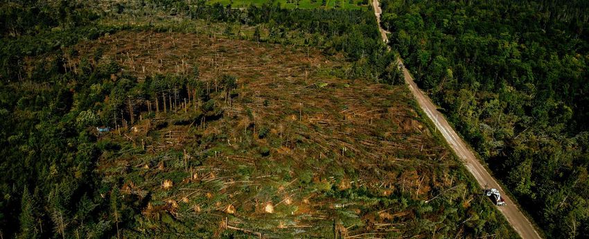
THE NORTHERN
                TORNADOES PROJECT

1    INDIGENOUS LAND ACKNOWLEDGEMENT
2    MISSION • VISION • VALUES
3    MESSAGE FROM NTP LEADERSHIP
4    ACKNOWLEDGEMENTS
5    THE TEAM
5         Leadership
6         Engineering
7         Meteorology
8         Structural and Wind Engineering
9         Geographic Information Science Technical Specialist/Communications Specialist
9    NTP OPERATIONS
10        Daily Outlooks
12        Crowdsourcing
13        Ground Surveys
14        Drone Surveys
15        Satellite Analysis
18        Aerial Analysis
19        Classification and Rating
20        Results Summary (2018)
25        Results Summary (2019)
28   NTP RESEARCH
28        Overview
30        Tornadic Storm Detection and Nowcasting Testbed
31   OPEN DATA SITE / REPORT A TORNADO
35   DO NOT TAKE THIS LIGHTLY
36   MEDIA AND CONFERENCES
37   IMPACT AT A GLANCE
38   APPENDIX A - NTP VERIFIED EVENTS (2018)
39   APPENDIX B - NTP VERIFIED EVENTS (2019)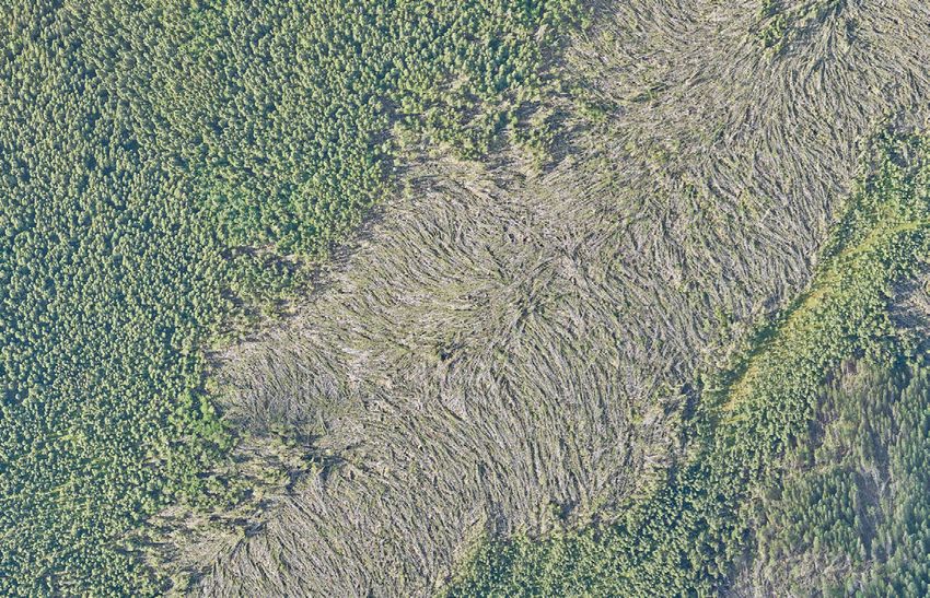
THE NORTHERN
   TORNADOES PROJECT

INDIGENOUS LAND ACKNOWLEDGEMENT

We acknowledge that Western University is located on the
traditional lands of the Anishinaabek (Ah-nish-in-a-bek),
Haudenosaunee (Ho-den-no-show-nee), Lūnaapéewak (Len-ah-
pay-wuk) and Attawandaron (Add-a-won-da-run) peoples, on
lands connected with the London Township and Sombre Treaties
of 1796 and the Dish with One Spoon Covenant Wampum. This
land continues to be home to diverse Indigenous peoples (e.g.
First Nations, Métis and Inuit) whom we recognize as
contemporary stewards of the land and vital contributors of our
society.

                                                                  1
THE NORTHERN
                         TORNADOES PROJECT

        The Northern Tornadoes Project (NTP) is a partnership between Western University
        and ImpactWX that aims to better detect tornado occurrence throughout Canada,
        improve severe and extreme weather prediction, mitigate against damage to people
        and property, and investigate future implications due to climate change. Western
        University also collaborates with Environment and Climate Change Canada, and several
        international universities on this Project.

                    VISION                                             VALUES

• That Canadians are better informed about                        Community driven
tornadoes and are able to better protect their
homes and communities.                             NTP is a community endeavour. It will take the
                                                   efforts of the full severe weather community of
• That NTP is an authoritative source on           scientists, emergency managers, media outlets,
tornado documentation and research in Canada.      and storm enthusiasts to ensure the Project’s
                                                   success across Canada. All of our research is
                                                   open access and freely available to the public and
                   MISSION                         other researchers.

• To better detect and document tornado                         Education & Awareness
occurrences throughout Canada.
                                                   NTP is developing new methods and tools to
• To improve communication of tornado science      increase our knowledge of tornadoes and push
and risk to Canadians.                             the boundaries of tornado research. It utilizes
                                                   satellites, surveillance planes, drones and on-
• To reduce damage to people and property.         ground observations to capture and analyze
                                                   tornado events and their damage. NTP is one of
• To better understand tornado climatology in      the most comprehensive tornado investigations
Canada to identify trends due to climate change.   ever undertaken in Canada and seeks to have a
                                                   national and international impact.

                                                                 Public empowerment

                                                   NTP is committed to saving lives, mitigating loss
                                                   and strengthening knowledge and understanding
                                                   of historic, recent and future tornado activity.

                                                                                                        2
THE NORTHERN
                            TORNADOES PROJECT

                                MESSAGE FROM NTP LEADERSHIP
Three years ago, we set our sights on finding at least    with a world-class team of engineers, meteorologists,
a few undocumented tornado tracks in the remote           and scientists. Our long-term vision is to cost-
forests of northern Ontario.                              effectively automate detection and classification of all
                                                          tornadoes in Canada. Our drone surveys and satellite
We have covered greater distances and nurtured            images are giving us unparalleled capabilities to
bigger ambitions since then.                              capture and analyze tornado events and their damage.
                                                          We also plan on harnessing the power of artificial
From northern Ontario to all of Canada, from              intelligence to automate our analysis of severe
aircraft surveys to drones and satellites, from on-the-   weather damage.
ground damage investigations to artificial intelligence
analyses, the Northern Tornadoes Project is one of        We are recruiting the right people. Our world-class
the most comprehensive tornado research projects          researchers (including two Vanier Scholars),
in the country. It aims to better detect tornado          engineers and meteorologists are creating dynamic
occurrences throughout Canada, improve                    and innovative research environments. Our newly
communication of tornado science and risk, and            hired full-time Communications Specialist is busy
mitigate against harm to people and property. NTP         communicating the Project’s research impacts to
also seeks to increase knowledge of tornado               national and international audiences and engaging
climatology to better understand trends due to            with our dedicated weather-enthusiasts on social
climate change.                                           media.

This report is our journey through the past three         We are community driven. We believe in the
years. It tells you where we have been, and where we      collective power and efforts of Canada’s severe-
are headed.                                               weather community to raise awareness and help us
                                                          grow bigger. Our Frequently Asked Questions page
The Northern Tornadoes Project took off through           gives people a peek into the fascinating world of
generous donations from Toronto-based social              severe weather, and our team! Our Open Data site is
impact fund ImpactWX and Western University. The          a publicly accessible online database of historical and
funds got the project started, and helped expand it       recent Canadian tornadoes with detailed satellite,
from one province to the whole nation. We also            aerial, drone and ground surveys and analysis. We are
acquired cutting-edge technology, and built an expert     also leveraging the power of crowdsourcing via social
team of researchers, engineers, and meteorologists.       media and citizen science to expand our reach. For
This includes collaborations with Environment and         the past three years, people have submitted reports
Climate Change Canada, and research groups in             of tornado sightings from across Canada to our
Canada, United States, and the United Kingdom.            Report A Tornado section and NTP social media
                                                          accounts.The data are freely available to everyone.
As you read this report:
                                                          Our report details all the above and much more.
We are leveraging cutting-edge technology to              Take a walk through its pages. We are just getting
increase our knowledge of tornadoes and push the          started.
boundaries of tornado research.
                                                          Greg Kopp & David Sills
We are systematically collecting all possible tornado
damage and tree-fall data in Canada and analysing it

                                                                                                                     3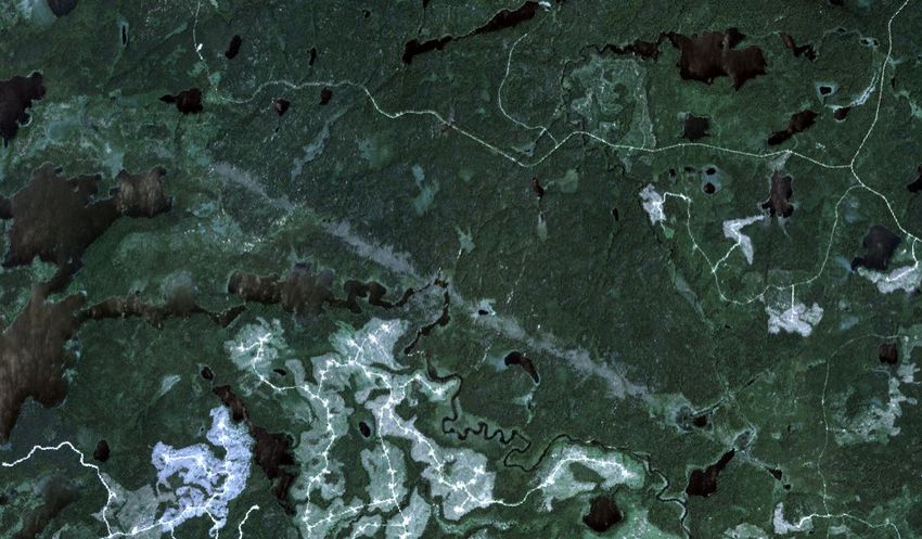
THE NORTHERN
                           TORNADOES PROJECT

                                    ACKNOWLEDGEMENTS
Western University                                   Environment and Climate Change Canada
                                                     (ECCC)
Donor Relations                                      Sandrine Eduard, Ahmed Mahidjiba, Peter Kimbell,
Terra Ahrens, Dana James                             Claude Mass, Kyle Fougere, Dave Carlsen, Blaine
                                                     Lowry, Dave Robins, Crawford Luke, Gerald Cheng,
Communications                                       Alexandre Parent, Simon Legault, Andre Cantin, Matt
Natalie Ebel, Jeff Renaud, Cory Habermehl, Gulnara   Albers, Bob Robichaud, Jim Goosen, Matt
Shafikova                                            MacDonald, Dennis Dudley, Chris Stammers, Natalie
                                                     Hasell, Geoff Coulson, Arnold Ashton, Rick Czepita,
Administration                                       Rob Reed, Vlado Stojanovich, Daniel Michelson,
Karen MacDonald, Nathalie Tournier, Michael          Emma Hung, Brian Greaves, Luc Cusson, Christine
Gaylard, Stephanie Davy, Heather Martin, Goretti     Curtis, Lindsay Hall-Carvalho, Joanne St-Coeur,
Fordyce, Laura Flemming                              Didier Davignon, Olivier Gagnon, Michel Jean

Procurement                                          Retired from ECCC
Scott Roth                                           Pat McCarthy, Ron Ruff

Technical Services                                   The Weather Network
Clayton Cook, Cody Ruthman, Steve Arnold,            Mark Robinson, Kyle Brittain
Karolina Kayko
                                                     InstantWeather
Computer Help Desk                                   Adam Skinner
Lyle McLean, Andrew Donkersgoed
                                                     The General Public
Library                                              This Project is a community endeavour. We would
Bobby Glushko                                        like to thank all of you who contributed crucial
                                                     information on tornado events, from providing drone
Intern                                               imagery to pictures of damaged sites and injury
William Wang                                         summaries.

                                                                                                           4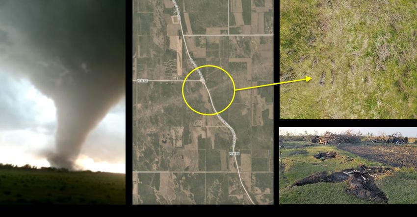
THE NORTHERN
                  TORNADOES PROJECT

                                NTP TEAM: LEADERSHIP

Dr. Greg Kopp is the ImpactWX Chair in         Dr. David Sills is Executive Director of the
Severe Storms Engineering and a professor      Northern Tornadoes Project. He received
in Western University’s Department of          a BSc in Atmospheric Science and
Civil and Environmental Engineering. He        Certificate in Meteorology from York
received a B.Sc.M.E. from the University of    University in 1993, as well as a PhD in
Manitoba in 1989, a M.Eng. from McMaster       Atmospheric Science from York University
University in 1991 and a Ph.D. in              in 1998. He worked for more than 20
Mechanical Engineering from the                years as a severe weather scientist with
University of Toronto in 1995. His             Environment Canada, conducting research
expertise and research relate to mitigating    on Canadian tornadoes, severe weather
damage to structures during extreme wind       nowcasting and mesoscale meteorology.
storms such as tornadoes and hurricanes.       He was awarded the CMOS Rube
He works actively to implement research        Hornstein Medal in Operational
findings into practice, currently serving as   Meteorology and the Geoff Howell
Chair of the ASCE 49 Standards                 Citation of Excellence for Innovation. Dr.
Committee on Wind Tunnel Testing For           Sills serves as Associate Editor for the
Buildings and other Structures, and as a       journals Atmosphere-Ocean and Monthly
member of various other Building Code          Weather Review. When not investigating
committees. A former Canada Research           the latest tornado, he also writes/performs
Chair in Wind Engineering, he is also the      indie folk-rock, is an avid photographer,
lead researcher for the Three Little Pigs      and sails the Great Lakes with his wife
Project at The Insurance Research Lab for      Heather.
Better Homes.

                                                                                              5
THE NORTHERN
                  TORNADOES PROJECT

                            NTP TEAM: ENGINEERING

Aaron Jaffe's Master's thesis on tornadoes is a   Connell Miller's PhD thesis is all about
series of high pressure situations – but think    protecting your home from the elements. The
data, not deadlines. During a tornado, flying     most common and popular types of cladding
debris often shatters windows and breaks          (like vinyl siding, and roof pavers) have air gaps
doors. Wind rushes in, and internal pressures     for drainage and installation purposes. After
push the roof and walls outwards. Outside,        wind storms, claddings often fail, even though
external pressures from the tornado pull the      they are designed to withstand that wind.
roof up and apart. Using model houses, wind       Connell (BESc [Distinction] '14, Structural
tunnels, and computer simulations, Aaron          Engineering, Western University) uses full-scale
(BESc '17, Civil and Structural Engineering,      experiments to better understand how wind
Western University) is helping predict internal   interacts with air gaps in common types of
pressures of houses when they are in the midst    residential cladding. His research will help
of tornadoes. His study, one of the most          create more accurate building codes for them.
comprehensive in his field so far, will help      "Cladding wind loads in current building and
engineers and home-builders construct             manufacturing codes are either inaccurate or
stronger, more resilient houses. "We can't stop   absent," he says. "That is why it is common to
tornadoes, but we can better predict their        see failures of cladding where there shouldn't
impacts, and design stronger houses to protect    be." Connell is also a Northern Tornadoes
against them," he says. As the Northern           Project's part-time research engineer and
Tornadoes Project's full-time research engineer   member of the Tornado Damage Survey Team.
and member of the Tornado Damage Survey           Apart from conducting damage surveys, he is
Team, Aaron conducts engineering analysis of      also responsible for developing and conducting
damaged and undamaged houses, analyzes            drone surveys. These map tornado paths at
aerial surveys of severe weather events, and      very high resolution, and allow better
summarizes the Team's damage reports.             examination of damaged vegetation and man-
                                                  made structures.
                                                                                                       6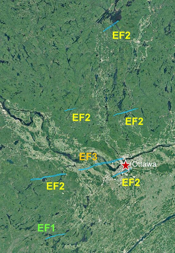
THE NORTHERN
                       TORNADOES PROJECT

                                 NTP TEAM: METEOROLOGY

During warm summer months, Lesley Elliott (BSc [Hons]        Joanne Kunkel (BSc [Hons] '12,
'04, Atmospheric Science, University of Alberta, MSc '06,    Atmospheric Science and Certificate in
Earth and Atmospheric Science, University of Alberta) is     Meteorology, York University, MSc '16,
exploring nearby parks and trails with her young family,     Atmospheric Science, York University)
hitting up a local farmer’s market, and also, tracking       roams Canada, almost 500 kilometres high
tornadoes with her keyboard and mouse. As the                with her keyboard and mouse. The country
Project's main research meteorologist, Lesley is routinely   sprawls across her computer screen, from
checking radar imagery (and sometimes satellite imagery      The Prairies to Southern Ontario to New
and lightning maps), and tornado-related hashtags on         Brunswick. The Northern Tornadoes
social media. She creates most of the Northern               Project's satellite analysis lead studies daily
Tornadoes Project's tornado outlooks (daily during the       satellite images, scanning for telltale signs
peak season from June to August, and only as needed          left in the wake of tornadoes and other
during the remaining months). The outlooks describe the      severe weather events - fallen trees, razed
risk of tornado formation (chance, likely or outbreak)       structures, damaged crops, for example. She
based on meteorological observations and various             is also continuously scanning over the
weather model output and are intended to prepare the         country, section by section, looking for
Tornado Damage Survey Team for possible action over          historical tornadoes, and uses her
the next several days. Lesley also creates event maps for    meteorological skills to contribute to the
the Team. The maps contain social media reports, radar-      daily tornado outlooks. Before heading out
based storm tracks, ground survey observations, and          to the field, the Project's Tornado Damage
sometimes, eyewitness accounts from locals. They also        Survey Team relies on Joanne's vital work
contain damage tracks observed with satellite imagery        and eye for detail to plan out survey routes
and flight plans for future high-resolution aerial imagery   and mark places of interest. As a
surveys. "I feel fortunate to be part of a group that is     meteorologist, she wishes people took
making sure that people are more aware of and better         tornado watches and warnings more
protected from tornadoes in Canada," she says.               seriously.

                                                                                                               7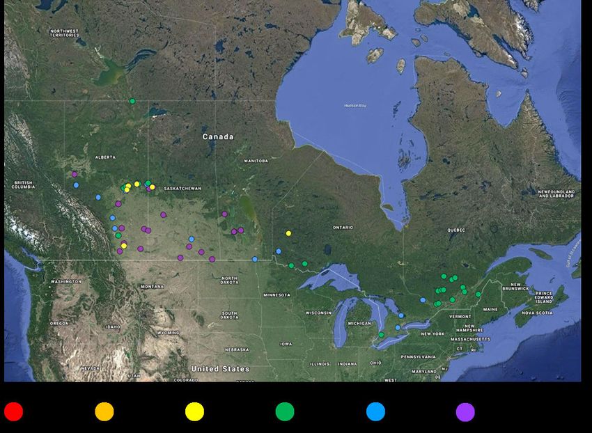
THE NORTHERN
      TORNADOES PROJECT

NTP TEAM: STRUCTURAL AND WIND ENGINEERING

        Sarah Stevenson (BSc [Hons] '15, Civil Engineering, University of Manitoba, MESc '17,
        Wind Engineering, Western University) is tearing apart houses for her PhD. With the
        click of a mouse, and some computer code, she buffets them with high winds, rams
        them through thunderstorms, swirls them around in tornadoes. By studying how
        severe wind events weaken the bones and joints of a house - connections between
        ground to floor, floor to wall, wall to roof (and everything in between), for example -
        Sarah's research is helping develop stronger, more resilient houses. Currently,
        Canada's building codes rarely take severe wind effects into account. With climate
        change potentially affecting severe weather patterns in the coming decades, Sarah's
        research is helping develop newer, more improved building codes. She is also a
        member of the Northern Tornadoes Project's Tornado Damage Survey Team, where
        she investigates the devastating after-effects of tornadoes on people's homes. The
        field studies, in addition to site inspections of new houses under construction, often
        find their way into her computer models, making her findings more realistic and
        practical than anything being currently studied.

        "Human impact in the wake of tornadoes and other severe weather events has
        always affected me,"says Emilio Hong (BESc '15, Civil and Environmental Engineering,
        Western University). "That's why we do what we do - to prevent this from
        happening again." The PhD scholar and Northern Tornadoes Project part-time
        research engineer is also a member of the Tornado Damage Survey Team. Following
        severe weather events, Emilio helps to analyze images obtained from drone and aerial
        surveillance that are used to determine the extent of tree damage and classify events
        into tornadoes, or downbursts, for example. The catch - he need to do it by eye. His
        solution - automate the procedure using computer modelling and artificial intelligence
        (AI) to drastically cut down analysis times. The AI program will also be able to scan
        drone or aerial photos of severe weather damage (tornado tracks, for example) in
        forests, and decide the type and severity of the event in seconds. The work will
        improve our knowledge on current risks and estimated effects of tornadoes.

        Ibrahim Ibrahim (BSc '12, Civil and Environmental Engineering, Alexandria University,
        MSc '17, Civil and Environmental Engineering, Western University) is building maps
        out of numbers. For his PhD, the former civil engineer is combining and analyzing
        decades of meteorological data from multiple sources such as radars, satellites, and
        wind observations. His hope - build a database for a map of North America that
        estimates downburst frequency anywhere in the continent. Currently, no such map
        exists. Critically, the comprehensive dataset will help civil engineers understand how
        downbursts affect buildings. "We have very good records for 'everyday' winds, but
        there is little data for downbursts," he says. As part of the Northern Tornadoes
        Project's Tornado Damage Survey Team, Ibrahim will be tracking - you guessed it -
        downbursts.

                                                                                                 8
THE NORTHERN
TORNADOES PROJECT
NTP TEAM: GEOGRAPHIC NTP TEAM:
INFORMATION SCIENCE COMMUNICATIONS
TECHNICAL SPECIALIST SPECIALIST
Geographic Information Science (GIS) is an incredible Aniruddho Chokroborty-Hoque (MSc '10,
data collection tool that helps elevate what engineers Microbial Ecology, Western University, PhD
do," says Liz Sutherland (BSc [Hons] '16, Geographic '17, Genetics and Neuroscience, Western
Information Science, Western University). As the GIS University) is a research communicator who
Technical Specialist for Northern Tornadoes Project has happily migrated from a fifteen-year stint
(and Western Libraries Map and Data Centre), she is conducting research to a lifetime of writing
integral to correctly storing, cataloging, and maintaining its stories. He is using multiple
massive amounts of information and data from the communication initiatives (e.g.
Project's aerial, drone, satellite, and ground surveys. commissioned op-eds, interviews, social
Prior to Liz's arrival at the Project, team members would media content, podcasts, videos shorts) to
conduct ground surveys, come back to the laboratory, communicate the 'so what, who cares?' of
pore over field data, and manually combine it with NTP research to its various audiences -
photographs, and aerial and drone surveys. Liz's researchers, policy-makers, weather
Survey123 app lets team members leverage the power of enthusiasts, and the general public.
GIS to capture field locations and gives them a form to Aniruddho works with the NTP team to
enter all descriptive data. "Within hours, I can turn those strategize and deploy storytelling strategies
data into maps and application through GIS shortly after to raise the Project's visibility on national
it is uploaded," she says. "The team can see all field data and international platforms. "I would like to
and important statistics, such as the number of damaged help establish NTP as the authoritative
trees or maximum wind speed assessments right away." source of open-access data and research on
Her work has saved the team valuable time by moving extreme weather events," he says.
away from tackling individual data points to combining it
under one platform and analyzing it immediately.
Another of Liz's contributions - the Project's Open Data
Site - is a pioneering example of a university-driven open
data platform being utilized by severe weather
researchers.
9THE NORTHERN
TORNADOES PROJECT
NTP OPERATIONS: Daily Outlooks
Daily forecasts of tornado potential enables readiness If a forecast was particularly challenging and/or
of the NTP team, by both heightening the awareness tornado risk was elevated above ‘chance’, some
of research staff observing events in real time (e.g., discussion and collaboration typically occurred within
monitoring storms on radar for supercell the forecast team to refine risk areas and levels with
thunderstorm features, checking social media for the highest confidence possible.
relevant witness or damage reports, etc.) and
providing ground survey teams with advance notice In 2018, the tornado outlooks focused on the
of potential deployment. While only a small fraction development of supercells and/or a quasi-linear
of storms will produce a tornado, accurately convective system (QLCS), with polygons
identifying the areas at risk is an important step in the representing risk levels for each parent-storm type
NTP methodology. overlaid on a map of Ontario when a risk above
marginal was identified by the forecaster (e.g., Figure
During the 2018 and 2019 NTP campaigns, tornado 1).
outlooks were produced daily starting in early June
through to mid-September, and on an as-needed basis A text summary of the anticipated storm
in the shoulder months. environment accompanied the map. These outlooks
also included additional graphics displaying forecasted
Tornado potential on Day 2 (i.e., the following day) synoptic scale weather features (e.g., frontal
was identified by the forecaster, with updates to risk boundaries) and when applicable, relevant
levels and areas issued for Day 1 when warranted. In probabilistic model output fields.
the event there was model consensus of a possibly
significant tornado event several days in advance, a
Day 3 outlook would be produced as well.
During the 2018 NTP, with the focus solely on
Ontario, the forecaster could confidently issue Day 3
and Day 4 outlooks that contained no apparent
tornado risk (i.e., a map with no risk polygons) when
synoptic weather patterns creating stable
environments that would inhibit significant convective
activity were anticipated several days in advance.
With the expansion nationwide in 2019, the
forecaster would only invest time producing a Day 3
outlook if a significant tornado risk was apparent in a
given region. Figure 1: NTP Tornado Outlook for September 21,
2018.
continued on next page -
10THE NORTHERN
TORNADOES PROJECT
NTP OPERATIONS: Daily Outlooks (continued)
The 2019 NTP expansion nationwide resulted in three EF2s and one EF1 tornadoes developed in the
several refinements to the methodology and outlook 'likely tornado' risk area and one EF1 tornado
template through discussion and feedback within the developed in the 'chance tornado' risk area. On
forecast team (which increased from two to three September 13, no tornadoes developed in the ‘likely
meteorologists). Changes to the tornado outlooks tornado’ risk area, although an NTP ground survey
included removal of additional graphics and utilizing confirmed an EF0 downburst caused damage in the
national maps and summaries with fewer details when ‘chance tornado’ risk area.
tornado risk did not exceed ‘chance’. Additionally, a
new polygon was introduced on the national map that
identified areas where any type of thunderstorm
development (unorganized or organized) was possible
(e.g., Figure 2).
When a tornado risk above ‘chance’ was identified, a
regional map was included with an expanded
summary discussing expected parent-storm type and
key environmental parameters (e.g., Figure 3). This
streamlined process was in place for the forecast
team by early August 2019.
Upon completion of the tornado outlook, the Figure 2: NTP Tornado Outlook for August 27,
forecaster saves a copy of the PowerPoint file as a 2019.
PDF and uploads the files to an NTP shared folder on
Google Drive. An email is sent to the NTP team that
includes a Ground Survey Team Alert Level, which
indicates the chance of deployment to the field within
an identified risk area (low, moderate or high).
Ideally, a Day 2 outlook is issued by the early
afternoon, which gives the ground survey team
advance notice of the potential for active weather
and deployment within 48 hrs. If a Day I update is
warranted, it is prepared and shared with the team
by mid-morning.
After the revised outlook template was adopted in
early August 2019, it was decided that the NTP
Twitter account would post an outlook publically in
the event that a ‘likely tornado’ risk (or higher) was
identified by the forecast team. This occurred on two
occasions: August 21 (the Day 2 outlook identified a
likely tornado risk in south-central QC) and
Figure 3: NTP Tornado Outlook with regional map
September 13 (a Day 1 updated identified a likely
and expanded summary, August 21, 2019.
tornado risk in southwestern ON). On August 21,
11THE NORTHERN
TORNADOES PROJECT
NTP OPERATIONS: Crowdsourcing
The principal source of witness and damage reports to complete a ground survey, contact is made with
collected during the 2018 and 2019 NTP campaigns the account holder to request further information
was public posts to popular social media platforms about eyewitness reports, additional details about
(i.e., Twitter, Facebook, Instagram, YouTube). location, timing and damaged incurred and/or copies
of high-resolution images/video for analysis and
Social media users – ranging from individuals to public archiving.
and private organizations – can quickly share
information online through posts and/or comments The research meteorologist saves relevant social
(typically accompanied with a photo or video) during media posts on the various platforms by taking screen
or after an event. Initial Twitter searches focus on captures and recording the link to the post.
posts with relevant hashtags (e.g. #onstorm for Additionally, posts on Twitter can be ‘liked’ and
storm-related posts in Ontario, #ottweather for an Facebook posts can be saved to a collection, allowing
Ottawa weather-related post). Searches are also for quick recall on those platforms.
completed for specific location tags (at times guided
by review of storm location as seen by radar) and Additional sources of reports include information
keyword combinations (e.g., ‘Calgary’ AND ‘funnel passed via email to NTP by contacts within ECCC,
cloud’). who receive many direct reports from the public and
from trained spotters. Witnesses are also encouraged
In spring of 2019, NTP introduced specific hashtags to submit reports via the NTP website. During the
for posts that are directly related to possible tornado active months of 2019, eleven reports were
events in each province and territory of Canada (e.g., submitted directly to the NTP team in this manner,
#bcNTP, #ykNTP, etc.). This helped NTP team including reports from five tornado events already
members quickly track and follow up on events. A under investigation and two previously unknown
key source of information on Facebook are the reports that were assessed as 'vortex-funnel cloud
Instant Weather regional community pages created aloft' events. Additional reports included historical
for all areas in Canada. Some of these pages, tornado damage, straight-line wind damage and
particularly the Ontario and Prairie province pages, witness photos of non-severe cloud features.
are very active during a severe weather event with
witness accounts and/or reports of local damage Information gleaned from the witness and damage
incurred. reports collected by the NTP team are plotted on a
map shared on Google Drive with all team members.
Several other public Facebook community pages A Google My Maps event map is created for each day
operated by storm chasers in active regions are also with relevant reports (divided up into western and
accessed regularly. Additionally, NTP team members eastern regions). Data points are added to the maps
have joined several private Facebook groups for each area where damage is reported or a witness
discussing active severe weather in specific regions of reported a tornado or potential tornado event.
Canada (e.g., the “Alberta Storm Chasers” group).
A complete record includes a brief description of the
If there is doubt regarding the authenticity of a report, an approximate time of event, the location (as
report, comparing images/video to street view in specific as possible), a link information source,
Google Maps and/or Google Images allows for quick photo(s) of the post and additional media shared, and
verification of the validity of the report. In some notes with other relevant information added by the
instances, and especially when the NTP team is likely research meteorologist.
12THE NORTHERN
TORNADOES PROJECT
NTP OPERATIONS: Ground Surveys
Ground surveys are a long-standing method of wind The NTP damage survey app was developed to make
damage investigation. They are particularly useful the survey process quicker and more efficient. This
when structures are damaged, and the details of app, installed on tablets and cell phones, is used by
construction can be captured. In fact, some details the surveyor to quickly record site information and
important to the rating of wind damage can only be take photographs, linking data to the GPS-derived
obtained on the ground by well-trained surveyors. location of the event with its name, degree of
damage, estimated wind speed, type of damage, etc.
Because damage is often cleaned up within a day or Added benefits of this app include sending the
two of the event, including clues that may be key to information back immediately and a more
understanding the type and intensity of the wind standardized process, as opposed to the previous ad
phenomenon, the ground survey team needs to be on hoc approach.
site as soon as possible after the event.
The survey teams will also often talk with witnesses
The NTP tornado outlooks help to ensure that to the event, as they can provide critical information
potential surveyors are ready to travel at a moment’s that helps to interpret damage details correctly. One
notice. example is noting whether doors to a farm building
were left open, since this increases susceptibility to
Not all events warrant a ground survey. First, ground wind loading and therefore can affect the EF-scale
surveys can only be performed if the damage is rating.
accessible by road. In some cases, damage is very
localized and photos or video available via news or For heavily damaged structures, the team undertakes
social media provide sufficient evidence adequately an engineering analysis of the various connections
characterize the event. (e.g., wall to roof) and other failures on the building.
Pictures are taken of these connections and failures
Ground surveys are most often used when there is for further analysis.
significant structural damage or when the cause and/
or scope of damage is unclear. These detailed studies help formulate solutions to
mitigate against future structural damage to buildings
Once on site, there can be different approaches for due to tornadoes.
the survey depending on the scope of the damage. In
some cases it may be sufficient to view the damage As the survey progresses, the route taken by the
while driving the local road network, documenting survey team is tracked to identify all areas surveyed.
more significant damage along the way. These are This improves the reliability of the survey, knowing
typically lower intensity events. which areas were accessible and which areas were
not accessible but could possibly have damage that
For larger events with higher intensity damage, may be found later via aerial analysis.
surveyors may record data on a door-to-door basis.
In total, 54 ground surveys were conducted (26 in
In each case, the surveyors typically begin their work 2018 and 28 in 2019).
in the area of worst damage and work outwards until
the threshold of damage (and therefore the length
and width of the damage path) is identified.
13THE NORTHERN
TORNADOES PROJECT
NTP OPERATIONS: Drone Surveys
Remotely piloted Unmanned Aircraft Systems Using and evaluating orthomosaic mapping was a
(commonly known as drones) are aircraft without a focus for NTP in 2019 (e.g., Figure 1) . Orthomosaic
human pilot on board. They are controlled from the maps are made up of a series of individual photos
ground either by remote control or autonomously which have been merged to form one composite
with pre-programmed flight paths. In 2018, drones image that has been adjusted for topographic relief,
were used to take single aerial photographs of lens distortion, and camera tilt. These corrected
damaged structures. In 2019, our goal was to use composite images allow for the same accuracy as
them to improve the quality of data for research and satellite or aerial imagery, but with higher resolution
classification purposes. We increased our drone fleet and a faster deployment time.
by adding two “Mavic 2 Pro” drones, which are
equipped with a 20-megapixel camera with a one - One of our new Mavic 2 Pro drones was equipped
inch sensor - the highest quality camera currently with a near-infrared (all instances). The near infrared
available on a commercially available drone. spectrum measures chlorophyll amounts in a plant by
analyzing the quantity of near-infrared light it reflects.
For research-quality imagery with even higher (The more near infrared light reflected, the more
resolution (order of centimetres), aerial photography chlorophyll in the plant.) With this, we can generate
is often used. However, aerial photography from normalized difference vegetation index (NDVI) maps.
traditional aircraft can take a significant amount of NDVI maps are used for determining overall plant
time to obtain, which can lead to delays in health in grass and low-lying crops that may not show
determining damage classification and rating, and may visible signs of tornado damage. For the 2020
not capture the full scope of damage due to the area tornado season, the goal is to have orthomosaic
being cleaned up over those months. By flying drones mapping for every ground survey we perform. To do
over damaged areas using pre-programmed grids, this, research will go into finding drones that are
high-quality data such as orthomosaic maps, 3D capable of flying beyond visual line of sight for an
models, digital terrain models, and digital surface extended period of time, to improve the speed at
models can be generated. which we can do this mapping.
Figure 1:
Lac des Iles
SK, 2019
Drone-derived
orthomosaic map
(1.5 centimetre
resolution).
14THE NORTHERN
TORNADOES PROJECT
NTP OPERATIONS: Satellite Analysis
The Northern Tornadoes Project uses high- (130+) of Earth imaging Doves (3 metre resolution)
resolution (3-5 metre) satellite imagery (via that line scan the Earth, as well as five RapidEye (5
planet.com) to to help identify tornadic damage paths, metre resolution) satellites. Doves orbit the poles
as well as damage associated with downbursts and every 90 minutes, capturing Earth’s entire landmass
hail swaths. Over forested regions, tree fall is every day.
generally straightforward to detect as it creates
noticeable scars. It is a pivotal tool for NTP damage analysis. Using
Planet`s “Compare” tool, satellite images taken
When possible, ground surveys, aerial and drone before and after the date of interest, most often at 3
flights are also conducted over these forested areas metre resolution, are seen side-by-side for
to collect high-resolution data for research. comparison. This tool makes satellite analysis much
However, over agricultural and treeless northern more efficient, as we can quickly see if there have
landscapes, tornado tracks are not as easily detected been any noticeable changes to the landscape after
via satellite imagery. the storm.
Strong attention to detail is required while searching But, satellite analysis is not a quick task, as some
these landscapes, but even then, not all damage will search regions can be as large as 50,000 square
be visible with satellite imagery. Therefore, it is kilometres (as was the case for the tornado outbreak
essential to conduct ground surveys, aerial and drone in Alberta and Saskatchewan on June 28, 2019).
flights.
Additionally, cloud cover and smoke from wildfires
Currently, Planet`s Surface Reflectance (SR) product can make the latest available imagery unsuitable for
is being researched as a potential means for our needs and several days, sometimes weeks, can
identifying tornado tracks over these more pass before clear imagery becomes available.
challenging landscapes. The Surface Reflectance
Product is often used in the agricultural industry for However, we can get lucky and cloud-free satellite
real-time monitoring of crop health. For NTP`s imagery becomes available one or two days after an
purposes, these day-to-day changes in the reflectance event. When we have survey teams on site
of crops and/or grass, may help us better determine conducting ground and drone surveys, having clear
whether a tornado had occurred over agricultural or imagery available shortly after the event has been
treeless landscapes, especially when there are no used to inform and direct the team to unreported
additional sources of information to verify a tornado's locations of damage.
occurrence.
In 2019, NTP used Planet`s SkySat satellites for five
Satellite analysis begins after supercell and QLCS storm damage events (Sapawe, ON on July 26, 2019 •
storm tracks have been identified from radar analysis Lac-des-Ecorces, QC on August 21, 2019 • Black
and crowdsourcing (weather office reports, posts Lake, MB on July 11, 2019 • Baie Saraana, QC on
from storm chasers and the public on Twitter and/or September 5, 2018 • Dakin Lake, SK on June 9, 2018).
Facebook, for example). The storm tracks are SkySat is a constellation of 15 high-resolution (0.8
created in Google Maps, and uploaded into Planet metre) Earth imaging satellites with near infrared and
Explorer where the hunt for damage begins. Planet is video capabilities. It is used on a per-request basis
the world’s largest collector and distributor of Earth- and can visit any place above the Earth.
imaging satellite data. It operates the largest fleet
continued on next page -
15THE NORTHERN
TORNADOES PROJECT
NTP OPERATIONS: Satellite Analysis (continued)
NTP requested the use of SkySat in order to obtain When satellite analysis is our only tool to classify and
higher resolution imagery of the tornado tracks and rate tornadoes, a set of somewhat conservative
treefall. Imagery collected helped more accurately guidelines has been developed to ensure consistency.
detect locations of treefall, but the resolution was Damage should be classified as tornadic if:
not high enough to see treefall direction and patterns,
which is of interest to NTP for research. Therefore, • Major areas of damage are aligned (line or gentle
the additional field methods continue to be important curve), with no along-path gaps greater than 2 km
tools for analysis.
• Aspect ratio of aligned damage path approaches or
Satellite analysis can not only be used to detect exceeds 10:1
recent storm tracks, it can also be used to search for
tornadoes that occurred years, even decades ago. • Path width less than 2 km, and total length at least 1
km
While conducting analysis, sometimes we come
across older tornado tracks. Once a tornado track is • Can be a wider area of minor non-tornadic damage
spotted in satellite imagery, it is cross-referenced in the vicinity but mostly to one side of the tornado
with an extensive tornado database to determine damage path
whether it is a known tornado on record, or a
previously unknown event. If it is determined to be If SkySat imagery is available and shows clear evidence
an unknown event, the track is dated, classified and of rotation in the tree damage, that can be also be
rated. used to assess the damage as tornadic.
Planet`s Monthly Mosaic Images can be used to help For the EF-scale rating of damage, we rule out EF0
date tornado tracks that occurred from 2016 events as we have found that this weak damage is
onwards. Once a month is determined, Planet`s Daily rarely captured via satellite imagery. If a track is
Imagery is used to pinpoint a date range. evident, but the damage is spotty, the tornado is
rated EF1.
If the tornado occurred prior to 2016, Google
Earth`s historical imagery is used to pinpoint a year A tornado is rated EF2 when a clear track is
and then Planet`s Daily Imagery is once again used to observed with large areas of trees uprooted and/or
narrow down a date. snapped (e.g., Figure 1 and 2). Currently, we do not
rate tornadoes above EF2 using just satellite imagery.
Using archived United States Storm Prediction
Centre mesoanalysis data (available from 2005) and Satellite analysis is an essential tool for improving the
historical radar data from ECCC, we can determine a tornado database and is critical to advancing our
date and time the tornado likely occurred. understanding of the climatology of these events.
However, if the tornado occurred prior to 2009, In the future, the Northern Tornadoes Project hopes
Google Earth is currently our only data source and to automate the detection of damage paths seen in
determining which storm the tornado belonged to high-resolution satellite imagery. However, this is an
and pinpointing a date is a difficult task. area of current research and development.
continued on next page -
16THE NORTHERN
TORNADOES PROJECT
NTP OPERATIONS: Satellite Analysis (continued)
Figure 1: Satellite Imagery of Buffalo Lake Metis Settlement, AB captured (left) before the event
on June 16, 2019, and (right) after the event on July 26, 2019. Rated EF2.
Figure 2: Satellite Imagery of Little Trout Lake, ON captured (left) before the event on July 3,
2019, and (right) after the event on July 28, 2019. Rated EF2.
17THE NORTHERN
TORNADOES PROJECT
NTP OPERATIONS: Aerial Analysis
The main goal of obtaining aircraft aerial imagery is to term research goals. For example, large data sets of
increase the quality of survey data and the detailed tornado paths are critical in helping NTP
subsequent analysis. This damage imagery, most often develop automated treefall detection algorithms.
obtained in forested areas, captures aspects of the
event that cannot be obtained from the ground. It Aerial analysis also helps confirm tornadoes that
also has much higher resolution (typically 5 would otherwise go unclassified. This is helping NTP
centimetre) than what is available via satellite imagery paint a more accurate picture of actual tornado
(typically 3-5 metres). occurrence and risk in Canada, and contributing to
improving tornado warning systems, and raising
Crewed aircraft can collect a series of high-resolution public awareness.
photographs (enough to capture most EF0 damage)
of a given area. The photographs can then be stitched Aerial surveys will continue to improve in the next
together (i.e., processed) to make a high-resolution, few years. NTP hopes to take advantage of improved
geo-referenced aerial map. NTP typically conducts resolution capabilities of up to 2.5 centimetre, in-
aerial surveys for more significant tornadic events, house processing of raw aerial data, and automation
especially those that include severe tree damage. of treefall detection in the near future. The surveys
will continue to be used for large and difficult-to-
Unlike satellite analysis, aerial surveys are only access events.
conducted for confirmed tornado tracks with
precisely known locations. There is often a significant
period of time between the event and the time the
flights are completed, and even longer before
processed images are available. This means that
preliminary event classifications and ratings must be
made prior to the completion of the aerial survey.
NTP is investigating the processing of raw aerial data
in-house in an effort to reduce this latency.
After the aerial imaging company delivers processed
aerial data to NTP, it typically takes about a day –
depending on the size of the event – to identify all the Figure 1: The figure strip on top outlines tornado
damage. Currently, this is done manually by combing damage occurring on September 21, 2018, at Val-des-
through the imagery and outlining likely and potential Bois, QC. Bottom figure is a close-up of the worst
tornadic damage (e.g., Figure 1). This process could damaged area along the tornado’s path. The damage
become automated to a certain degree in the future. outline is shown in red and the tornado path ‘centre
The vast majority of identified damage is snapped line’ is shown in yellow. A box with sides equal to half
and/or uprooted trees, as the structural damage is of the maximum width along the path is shown in
often cleaned up by the time the aerial survey is black. The box is placed along the centre line of the
flown and has typically already been assessed by an area of worst damage, and the percentage of trees
on-site ground survey. snapped and/or uprooted within the box determines
the maximum wind speed, and subsequently, EF-scale
Aerial analysis is actively contributing to NTP’s long- rating. In this case, over 80% of the area of the box
had trees down. Maximum wind speed was assessed
at 190 km/h which is in the EF2 wind speed range.
18THE NORTHERN
TORNADOES PROJECT
NTP OPERATIONS: Classification & Rating
From the collected data, event classification and range from the threshold of visible damage to total
rating decisions must be made using the latest destruction. Each degree of damage has an associated
scientific understanding of severe weather wind speed range from which a representative
phenomena for classification and the Canadian EF- maximum wind speed is estimated. The EF-scale
scale for rating. The goal is to provide the most rating (between 0 and 5) is then assigned based upon
accurate event assessment possible. the estimated maximum wind speed.
When damage is present, the likelihood that the When damage is present, a ground survey is typically
damage was caused by a tornado versus a downburst done within a few days, including aerial imaging using
must be assessed. In cases where it is unclear which a drone. The field team recommends a preliminary
is more likely given the available evidence (usually EF-scale rating based on survey results. In cases
only weaker events), then a classification of where tornadoes are detected remotely using high-
‘unclassified wind damage’ is made. The damage is resolution satellite data, a preliminary EF-scale rating
further characterized by estimating the damage path is based on the evidence of tree damage and the tree
length and maximum width. damage indicator included with the Canadian EF-
scale.
When only visual evidence of a vortex is available, the
likelihood that it is a tornado or a non-tornadic When only visual evidence of a tornado is available,
vortex must be assessed. Non-tornadic vortices and no damage is caused to an EF-scale indicator, a
include vortices-funnel clouds aloft, gustnadoes, rating of EF0-Default is assigned. This indicates that a
sub-tornadic vortices, and dust devils. In cases where wind speed of at least 90 km/h (the lower bound of
the type of non-tornadic vortex is unclear given the EF0 using the Canadian EF-scale) is expected to have
available evidence or does not fit into an existing been associated.
sub-category, it will be considered a general non-
tornadic vortex with no sub-category and specific After a tornado or downburst has occurred,
text details included. preliminary assessment results are typically desired
for media and public information purposes within
Waterspouts, defined as tornadoes over water, have 24-48 hours of an event.
historically not been included in Canadian tornado
data sets for large bodies of water (i.e., at least Given ECCC distributes this type of information via
10,000 sq km). This is mainly due to ECCC program storm summary bulletins, there is typically discussion
jurisdiction issues (public versus marine programs). between ECCC and NTP to reach consensus on the
These tornadoes are now being included in NTP data preliminary assessment before it is broadcast.
sets on an experimental basis, but are not included in
annual statistics for the time being. However, even after the preliminary assessment has
been disseminated publicly, there is typically weeks to
The Canadian version of the EF-scale is used to rate months more work for NTP collecting all possible
the intensity of the damage caused by a tornado, evidence and re-assessing as new evidence comes in.
from which estimates of maximum wind speed can be For significant tornadoes, this often includes specially
obtained. The Canadian EF-scale uses 31 different requested aircraft aerial imagery.
‘Damage Indicators’ (from buildings to trees to
electrical transmission structures). Each damage Once all evidence is considered, NTP determines a
indicator has associated ‘degrees of damage‘ that final assessment - with each approved by NTP's
Executive Director.
19THE NORTHERN
TORNADOES PROJECT
NTP OPERATIONS: Results Summary (2018)
This section will highlight the results of the NTP Waterspouts over large bodies of water such as the
event investigations for 2018 and 2019, focusing on Great Lakes were verified and documented on an
events classified as tornadoes. The goal for the 2018 experimental basis.
campaign was to detect every EF1+ tornado in
Ontario and investigate significant tornado events in Events verified by NTP in 2018, including tornadoes,
other parts of Canada. tornadoes (experimental), downbursts, non-tornadic
vortices, and unclassified wind damage
Based on the success in 2018, the Project scope
expanded to include the detection of every tornado
in Canada in 2019.
2018 Events
Though the 2018 tornado season started quite late
(first tornado of the season on June 13) and ended
somewhat early (last tornado on September 25th), it
was a busy one with a number of significant events
(Figure 1).
Several of these events will be discussed below.
The following are brief summaries of three significant
NTP verified the occurrence of 54 tornadoes in total, events investigated by NTP in 2018.
with 10 occurring outside of Ontario and Quebec
(Fig.1). Since Quebec had such an active tornado August 3 – EF4 tornado in Manitoba
season, the focus for 2018 ended up being split
between Ontario and Quebec. Of the 44 tornadoes On August 3, 2018, near 8 PM local time, a violent
in those provinces, 32 of them were discovered by tornado developed in southern Manitoba affecting the
NTP and would otherwise have gone undocumented small community of Alonsa (Figure 2). The tornado
– an increase of 267%. caused catastrophic damage along a path 15.1 km
long and 1.2 km wide, resulting in one fatality and a
Appendix A has a detailed list of the 2018 tornado few injuries. Insured losses were estimated by NTP
events. to be over $2M.
NTP also documented a significant number of In 2018, no NTP tornado outlooks were produced
downbursts and non-tornadic vortices. When the for areas outside of Ontario, but the team responded
cause of wind damage was not possible to verify, it quickly with a two-person survey crew on the ground
was categorized as unclassified wind damage. within 5 days. NTP survey teams performed detailed
ground surveys, collected drone imagery and
coordinated with ECCC staff from the Winnipeg
office.
continued on next page -
20THE NORTHERN
TORNADOES PROJECT
NTP OPERATIONS: Results Summary (2018) (continued)
Several homes were destroyed and moved off their aerial and satellite imagery were used to characterize
foundations. While normally this would result in an each of the 14 tornado damage paths.
EF5 rating, it was determined that the construction
quality prevented a rating above EF4. NTP acquired The record for Quebec’s largest recorded tornado
additional high-resolution imagery from both satellite outbreak was set on June 18, 2017 at 11 tornadoes.
and aircraft platforms. All event data were This 14-tornado outbreak in 2018 – the very next
synthesized and analyzed to characterize the event. year – has broken this record. As with the 2017
outbreak, it ranks among the largest recorded in
At an EF-scale rating of EF4, this was the highest- Canada.
rated tornado in North America in 2018 (perhaps the
world – a violent tornado was alleged to have September 21st – Tornado outbreak in Ontario / Quebec
occurred in South America but evidence is hard to
come by). It was also the first tornado rated at EF4 During the afternoon and evening of September 21,
under the new Canadian EF-scale, and the first EF4+ seven tornadoes occurred across a large area from
tornado in Canada since the 2007 EF5 tornado at Sharbot Lake in eastern Ontario to Grand-Remous in
Elie, MB (roughly 100 km away). southern Quebec. Three of the tornadoes ripped
through urbanized areas, causing devastating damage
September 5th – Tornado outbreak in Quebec up to EF3 in strength. Amazingly, there were no
fatalities, though there were 23 injuries, a few
During the afternoon and evening of September 5th, serious. Hundreds of structures were damaged or
14 tornadoes occurred over a large area in southern destroyed, including homes, apartment buildings,
Quebec stretching from well north of Ottawa to commercial buildings, farm buildings, and electrical
north of Quebec City. Tornadoes of EF1 and EF2 stations and towers, with insured losses estimated at
strength caused mostly tree damage in this heavily over $300M.
forested region. There were no known injuries and
insured losses are unknown. The NTP tornado outlook identified an area of likely
supercell tornado development in eastern Ontario
As mentioned earlier, NTP tornado outlooks in 2018 nearly a day in advance. Given the ‘likely’ area ran
covered only Ontario, but an area depicting the along the border, the risk was implied for
chance of supercell tornadoes was identified in neighbouring parts of southern Quebec.
eastern Ontario (and was implied for neighbouring
parts of southern Quebec) a day in advance. Since Four NTP team members joined six ECCC surveyors
thorough investigations during the summer of 2018 (from the Toronto, Montreal and Ottawa offices) in
were limited to Ontario, the tornado damage from the Ottawa region over two days (Figure 4). Most of
this outbreak was only discovered in 2019 while the time was spent on the EF3 damage path that
looking for damage from 2019 storms. There were stretched 47.6 km through Dunrobin, ON and
no reports on social media about this event, during Gatineau, QC, and on the EF2 path through Nepean
or after. on the southern edge of Ottawa. NTP surveyors also
investigated damage between Calabogie and Kinburn.
After the first eight damage tracks were identified, Drone imagery could not be collected for this event
high-resolution aerial aircraft data were obtained (see due to the many no-fly zones in the Ottawa area.
Figure 3). A further six tornadoes were found using
high-resolution satellite imagery only. Both aircraft
continued on next page -
21THE NORTHERN
TORNADOES PROJECT
NTP OPERATIONS: Results Summary (2018) (continued)
Thorough aerial analysis was also conducted using For those reasons, it is likely the most thoroughly
high-resolution satellite and aircraft aerial imagery, studied tornado outbreak in the country’s history.
and was instrumental to verifying changes to The insured losses also make it one of the most
preliminary findings (Quebec tornadoes were expensive tornado events in Canadian history. Finally,
upgraded to EF2, damage at Sharbot Lake was this event occurred quite late in the season – there
reclassified from downburst to EF1 tornado).This has been only one other recorded EF3 in Canada in
event affected a large population (perhaps the most September or later (Merritton, ON on September
of any tornado outbreak in Canada) in the nation’s 26, 1898).
capital, making it meteorologically and politically
significant.
Figure 1: Map showing all tornado events confirmed by NTP in 2018.
continued on next page -
22THE NORTHERN
TORNADOES PROJECT
NTP OPERATIONS: Results Summary (2018) (continued)
Figure 2: (Left) Screen capture
from Facebook video by
Shawn Cabak showing the
Alonsa tornado at its most
intense. (Centre) Satellite
imagery from planet.com
showing the WSW-ENE
tornado track. (Top Right)
Drone imagery showing that
the discolouration visible in
the satellite imagery (yellow
circle) is caused by both small
uprooted trees and dead/dying
grasses. (Bottom right) Photo
from Kyle Brittain providing
evidence that mature trees
were ripped out of the ground
and thrown downwind.
Figure 3: Aircraft aerial
imagery showing the entire
path of the Lac Flocon
tornado with red damage
outlines and yellow centre line
(top left), and an area along
the path where every tree was
flattened (bottom right). The
name, EF-rating, and estimated
maximum wind speed for each
of the 14 tornadoes in the
outbreak are shown at bottom
left (asterisks indicates
tornadoes for which aircraft
aerial data were obtained).
23You can also read