One Map Policy of Indonesia: Status, Challenges, and Prospects
←
→
Page content transcription
If your browser does not render page correctly, please read the page content below
One Map Policy of Indonesia: Status, Challenges, and Prospects

              Hasanuddin Z. ABIDIN, Nurwadjedi SARBINI, Lien ROSALINA,
            Dodi S. RIYADI, Wahyu UTOMO, Antonius B. WIJANARTO, Indonesia

   Key words: One Map Policy, Indonesia, geospatial, base map, thematic map

   SUMMARY

   The One Map Policy of Indonesia (OMP) is the program to integrate and synchronized the
   thematic maps of Indonesia to have one georeference, one standard, one database, and one
   geoportal. This program is regulated by the Indonesian Presidential Regulation no. 9/2016
   regarding the acceleration of the implementation of One Map Policy on 1:50.000 scale map
   accuracy, issued on 4 February 2016. The program handles 85 thematic maps of 19 ministries
   and agencies and covers 34 provinces in Indonesia.
         The program consists of four main stages, namely compilation, integration,
   synchronization, and data sharing. At the compilation stage, 85 thematic maps that have been
   produced by ministries and agencies were compiled and verified. The validated thematic maps
   are then integrated with the standard base map. Integrated thematic maps sometimes still
   contain several problems, such as overlapping land use permits and inconsistencies with
   existing spatial plans. All these problems are resolved at the synchronization stage. Since this
   stage is usually quite complicated and takes time to resolve, the process of sharing the OMP
   products is carried out after the integration stage is completed. Data sharing is done using a
   geoportal managed by the Indonesian Geospatial Information Agency, especially for
   participating ministries and agencies, as well as all provincial and local governments.
         The integrated and synchronized thematic maps of OMP should be used by the central
   and local governments as a reference, among others, for improving the quality of spatial
   planning and land use, resolving land-use conflicts, natural resources management, the
   realization of sustainable development goals, and disaster risk reduction management.
         The status of OMP will be presented in this paper, especially the achievements related to
   integration, synchronization, and data sharing activities. Problems and challenges encountered
   during the program execution are also discussed. The prospects for further strengthening of
   OMP is also discussed.

One Map Policy of Indonesia: Status, Challenges, and Prospects (10887)
Hasanuddin Z. Abidin, Rosalina Lien, Dodi S. Riyadi, Nurwadjedi Sarbini and Antonius B. Wijanarto (Indonesia)
FIG e-Working Week 2021
Smart Surveyors for Land and Water Management - Challenges in a New Reality
Virtually in the Netherlands, 21–25 June 2021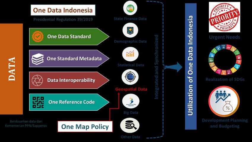
One Map Policy of Indonesia: Status, Challenges, and Future Plan

              Hasanuddin Z. ABIDIN, Nurwadjedi SARBINI, Lien ROSALINA,
            Dodi S. RIYADI, Wahyu UTOMO, Bambang S. WIJANARKO, Indonesia

       1. INTRODUCTION

   Indonesia has a vast land and maritime territory (about 5000 km by 2000 km), many islands
   (more than 17.500 islands), and abundant land and marine resources. Geospatial data and
   information are very much needed to develop and manage this vast territory and its natural
   resources in an effective, efficient, and sustainable manner. It should also be integrated with
   other non-spatial data and information, to make it more beneficial.
      In Indonesia, according to the Law no. 4/2011 on Geospatial Information and the Law no.
   11/2020 on Job Creation, the geospatial information is categorized into basic and thematic
   geospatial information, as shown in Figure 1. The basic geospatial information includes the
   information from geodetic control networks and base maps.

                            Figure 1. Geospatial data and information in Indonesia.

      Geodetic control networks of Indonesia consisted of static GPS geodetic control points (7209
   benchmarks up to the end of 2019), Static Leveling Network (5785 benchmarks up to the end
   of 2019), GNSS CORS stations (237 stations up to the end of 2019), Continuous Tide Gauge

One Map Policy of Indonesia: Status, Challenges, and Prospects (10887)
Hasanuddin Z. Abidin, Rosalina Lien, Dodi S. Riyadi, Nurwadjedi Sarbini and Antonius B. Wijanarto (Indonesia)
FIG e-Working Week 2021
Smart Surveyors for Land and Water Management - Challenges in a New Reality
Virtually in the Netherlands, 21–25 June 2021
Stations (159 stations up to the end of 2019), Main Gravity Control Networks (50 benchmarks
   up to the end of 2018), and the Indonesian geoid with the present accuracy of about 10 to 15
   cm. More detail information on those geodetic control networks can be seen in (SRGI, 2021).
       Currently, the base map of Indonesia is named the Rupa Bumi Indonesia (RBI) map, which
   is a three-dimensional digital map with 8 layers of information, namely coastline, hypsographic,
   hydrographic, geographical name, administrative boundary, transportation, and utility, building
   and public facility, and land cover. Base maps of Indonesia are covering land and sea areas,
   including the coastal area. The scales of these base maps are 1:1000 (specific area according to
   needs), 1:5000, 1:25.000, 1:50.000, 1:250.000, and 1:1.000.000. At present, the complete land
   coverage of Indonesian base map is at 1:50.000 scale, which part of it is derived from the base
   map of 1:25.000 scale. The Indonesian Geospatial Information Agency (BIG) is currently
   accelerating the establishment of a 1: 5000 scale base maps for land areas outside forest areas,
   and a 1: 1000 scale base map for certain target areas, such as metropolitan cities and certain
   economic development areas.
       Thematic maps in Indonesia have many themes and are usually based on an appropriate base
   map. Sources of thematic maps in Indonesia are ministries and agencies, local governments
   (provinces, districts, cities, and villages), private parties, non-governmental organizations
   (NGOs), and society at large. Due to the various sources of thematic maps, it is possible that
   these maps have unexpected characteristics, such as not using the same base map, unequal
   mapping standards, non-uniform quality, one theme that can be produced by several parties,
   and the existence of each thematic map is not always known to the public.
       Based on the Regulation of the Minister of National Development Planning/Head of the
   National Development Planning Agency of the Republic of Indonesia no. 5/2018 concerning
   procedures for preparing government work plans, it was stated that the national development
   paradigm is THIS (Thematic, Holistic, Integrative, Spatial). Based on this paradigm, all national
   development planning must be based on accurate and accountable geospatial data and
   information, in addition to other non-spatial data such as statistical data.
       In fact, all the other stages of the development process, i.e., implementation, monitoring,
   evaluation, and controlling will require geospatial data and information in various forms, as
   illustrated in Figure 2. In this case, data and information from geodetic control networks, base
   maps, and thematic maps will all be useful with their respective roles and functions.
        For thematic maps, because they can be made by various ministries, agencies, and other
   non-governmental parties, it is necessary to pay attention that all these thematic maps must be
   integrated and synchronized through One Map Policy program, before being used to support
   programs and programs related to national development activities. In addition, to make it more
   useful to support the national development process, geospatial data and information, including
   from the One Map Policy product, should be integrated with non-spatial data and information
   (such as statistics, population, finance, and other sectoral data), through One Data Indonesia
   program. One Data Indonesia (ODI) is a government data management policy that aims to
   create quality data, easily accessible, and can be shared between central agencies and local
   governments. This policy is contained in the Presidential Regulation no. 39 of 2019 concerning
   One Data Indonesia. More detailed information about this program and its products, can be seen
   at (ODI, 2021).

One Map Policy of Indonesia: Status, Challenges, and Prospects (10887)
Hasanuddin Z. Abidin, Rosalina Lien, Dodi S. Riyadi, Nurwadjedi Sarbini and Antonius B. Wijanarto (Indonesia)
FIG e-Working Week 2021
Smart Surveyors for Land and Water Management - Challenges in a New Reality
Virtually in the Netherlands, 21–25 June 2021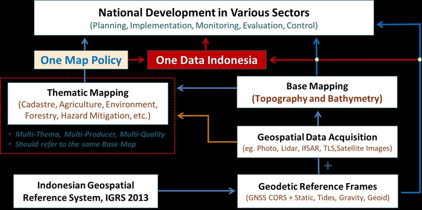
Figure 2. The roles of geospatial information for national development.

       2. ONE MAP POLICY: STATUS

       2.1 Thematic mapping problems in Indonesia

   Geodetic control network measurement for mapping purposes in Indonesia has been started
   since the Dutch colonial era in 1862, mainly based on the method of measuring triangulation
   and astronomical observations (Schepers & Schulte, 1931). Therefore, it is estimated that base
   mapping and thematic mapping in Indonesia was carried out systematically after the
   procurement of those geodetic control networks.
      If we study the history of base mapping in Indonesia, usually in a certain period there is only
   one government agency that is responsible for making the base map (Bakosurtanal, 2019).
   Currently the institution that is legally responsible is the Geospatial Information Agency of
   Indonesia (BIG), an agency formerly known as the National Coordinating Agency for Surveys
   and Mapping (Bakosurtanal). The main challenges in base mapping are generally in the
   updating of map contents, establishment of base maps at a larger scale and wider coverage,
   modernization of the geodetic datum for mapping, and modernization of mapping technology.
      Thematic mapping is generally done after base mapping because thematic maps must be
   made on top of the base map of the area concerned. In contrast to base mapping, thematic
   mapping in Indonesia can be carried out by ministries and agencies, local governments
   (provinces, districts, cities, and villages), the private sector, non-governmental organizations
   (NGOs), and the wider community. This will then lead to several unwanted problems. Figure 3
   shows some of the problems related to thematic mapping and thematic maps in Indonesia that
   we often encounter in the field, along with the negative impacts that occur.

One Map Policy of Indonesia: Status, Challenges, and Prospects (10887)
Hasanuddin Z. Abidin, Rosalina Lien, Dodi S. Riyadi, Nurwadjedi Sarbini and Antonius B. Wijanarto (Indonesia)
FIG e-Working Week 2021
Smart Surveyors for Land and Water Management - Challenges in a New Reality
Virtually in the Netherlands, 21–25 June 2021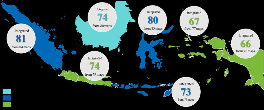
Figure 3. Several thematic mapping problems in Indonesia and their impacts.

       2.2 The Needs of One Map Policy in Indonesia

   Due to the existence of several problems related to thematic mapping and thematic maps in
   Indonesia so far as indicated in previous Figure 3, in the field it is often found that there are
   overlaps in land use. Overlapping land use between mining, plantation, and forestry areas often
   occurs. In this case, more than one authority from different regions sometimes issues permit in
   the same location (overlapping borderline), which leads to border area conflict. In another case,
   various land use permits sometimes overlapping in the same region, which leads to land
   disputes. Sometimes this overlapping problem is also made more complicated because it also
   violates the spatial planning regulation in the area. These overlapping problems will in turn
   create legal, social, economic, and environmental conflicts which in turn result in unattractive
   investment conditions, hinder the development process, delay project completion, and waste
   development energy.
      To overcome this problem, a standardized, accurate and accountable thematic map system
   is needed as a reference for all stakeholders in preparing development planning and related
   aspects. For this reason, the Indonesian government on 4 February 2016 issued the One Map
   Policy program which is expected to solve several problems in land use. This is regulated in
   Presidential Regulation No. 9 of 2016 concerning the Acceleration of the Implementation of
   the One Map Policy at a map accuracy of 1: 50.000 scale. The general characteristics of One
   Map Program is depicted in Figure 4. More detailed information about the One Map Policy
   program can be seen in Karsidi (2016) and Sarbini (2019).
      The goal of this OMP program is to compile, integrate and synchronize 85 thematic maps
   selected from 19 participating ministries and agencies to have one georeference, one standard,
   one database, and one geoportal. In this case, one georeference means that all thematic maps

One Map Policy of Indonesia: Status, Challenges, and Prospects (10887)
Hasanuddin Z. Abidin, Rosalina Lien, Dodi S. Riyadi, Nurwadjedi Sarbini and Antonius B. Wijanarto (Indonesia)
FIG e-Working Week 2021
Smart Surveyors for Land and Water Management - Challenges in a New Reality
Virtually in the Netherlands, 21–25 June 2021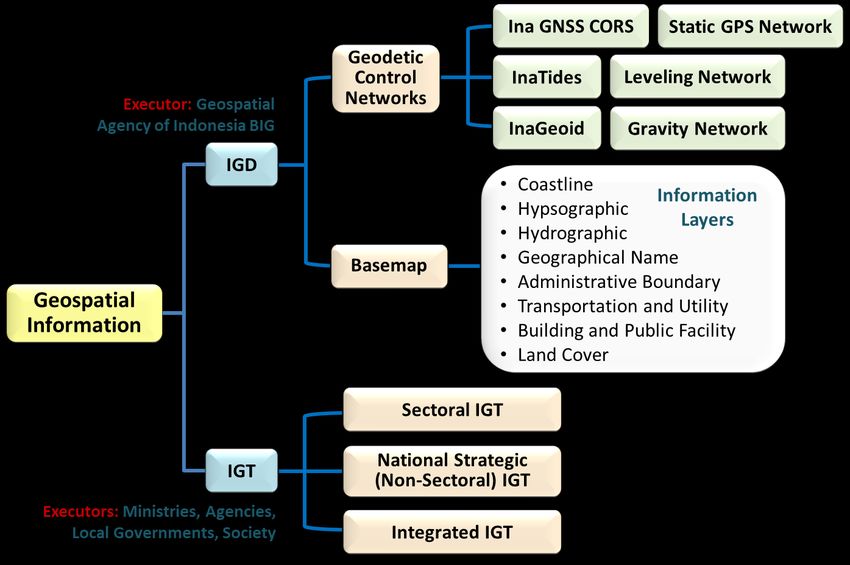
use the same base map and the same geodetic reference system, namely the Indonesian
   Geospatial Reference System, SRGI 2013 (SRGI, 2021). One standard means that all thematic
   maps use the same standard regarding the geographic elements, attributes, metadata, and
   thematic mapping methods used. One database means that all thematic maps from OMP must
   be in one database and not spread over several locations, making it easy to find and access. One
   geoportal means that all OMP products must be managed with one geoportal system to
   streamline and optimize the data sharing of OMP products between stakeholders through a
   national geospatial infrastructure network. The 85 thematic maps of OMP can be categorized
   into several large themes, namely Infrastructure (21 maps), Forestry (6 maps), Natural
   Resources, Environment, and Disaster (29 maps), Regional Boundary (5 maps), License and
   Permit (7 maps), Regional Planning (9 maps), and Specific Area and Transmigration (8 maps).

                     Figure 4. General characteristic of One Map Policy (OMP) program.

      The implementation of OMP involves many government agencies at the central level (19
   Ministries/Agencies) and Local Governments in 34 Provinces. To accelerate the
   implementation of OMP, the Government formed the OMP Acceleration Team chaired by the
   Coordinating Minister for Economic Affairs and consisting of several Ministries and Geospatial
   Information Agency.

       2.3 Compilation and Integration Stages

   The One Map Policy program consists of four main stages, namely compilation, integration,
   synchronization, and data sharing. The compilation is the activity stage of collecting,
   submitting, and storing thematic maps from various ministries/institutions which are custodians
   of the corresponding thematic maps. The purpose of compiling thematic maps is to collect them
   for integration and synchronization. Integration is a phase of activities to align thematic maps
   with base maps and standard geospatial databases. This integration activity includes verification

One Map Policy of Indonesia: Status, Challenges, and Prospects (10887)
Hasanuddin Z. Abidin, Rosalina Lien, Dodi S. Riyadi, Nurwadjedi Sarbini and Antonius B. Wijanarto (Indonesia)
FIG e-Working Week 2021
Smart Surveyors for Land and Water Management - Challenges in a New Reality
Virtually in the Netherlands, 21–25 June 2021
and editing of thematic data collected from the map custodian. The objective of integration is
to ensure the quality of the thematic maps according to the base maps and predefined standards.
The compilation and integration stages of One Map Policy are carried out in stages region
by region as shown in Figure 5. 2016 begins with the Kalimantan region, 2017 for the Sumatra,
Sulawesi, Bali and Nusa Tenggara regions, and 2018 for the Java, Papua, West Papua, Maluku,
and North Maluku regions.
Figure 5. The status of integration stage achievement by February 2020.
In general, the stages of compiling and integrating 85 thematic maps for the entire territory
of Indonesia have been carried out relatively well. Until February 2020, the compilation stage
of 85 thematic maps has generally been completed, with a note that the most recent compilation
is the village/kelurahan boundary administrative maps with a scale of 1: 10.000 are mostly still
an indicative (cartometric) maps, and only 362 village/kelurahan maps have been definitive,
out of more than 83,400 villages/kelurahan of Indonesia.
The achievements of the integration stage of the One Map Policy in each island region or
island group are shown in Figure 5. The achievements are different for each region. As of
February 2020, in the Kalimantan region 74 of the 80 thematic map targets have been integrated
(92.5%), in Sumatra 81 of the 84 thematic maps have been integrated (96.4%), in Sulawesi 80
of the 83 thematic maps have been integrated (96.4%), in the Bali and Nusa Tenggara region
73 of the 79 thematic maps have been integrated (92.4%), in Java region 74 of the target 79
thematic maps have been integrated (93.7%), in the Maluku and North Maluku region 67 of the
target 77 thematic maps have been integrated (87.0%), and in the Papua and West Papua region
66 of the 78 thematic maps have been integrated (84.6%).
It should be noted here that the thematic map targets for each region do not reach the 85
thematic maps. This is because not all thematic maps naturally exist in all regions, for example,
maps of peatlands on the island of Java, as well as maps of the distribution of railway networks
and railway stations in Papua and West Papua regions. In addition, there are thematic maps that
have not been integrated because they are still under procurement or nationally note yet
One Map Policy of Indonesia: Status, Challenges, and Prospects (10887)
Hasanuddin Z. Abidin, Rosalina Lien, Dodi S. Riyadi, Nurwadjedi Sarbini and Antonius B. Wijanarto (Indonesia)
FIG e-Working Week 2021
Smart Surveyors for Land and Water Management - Challenges in a New Reality
Virtually in the Netherlands, 21–25 June 2021complete, for example, land cover map, land system map, morphometric map, and village
boundary administrative map.
2.4 Synchronization Stage
The main objective of the synchronization phase of the One Map Policy is to synchronize the
integrated thematic maps with the main objective of resolving overlapping land uses.
Synchronization of thematic maps is carried out through 3 (three) activity stages, namely
identification of overlaps, analysis of overlapping solutions, and implementation of overlapping
solutions. The data source for synchronization is integrated thematic maps, especially those
related to land use status.
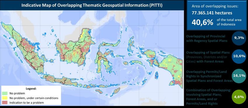
Figure 6 shows one of the products of the synchronization stage, namely the Indicative Map
of Overlapping Thematic Geospatial Information (PITTI) for Indonesia. More detailed PITTI
for the six regions as shown in Figure 5 have also been produced. PITTI for the six regions has
been legally established through a Decree of the Coordinating Minister for Economic Affairs
of Indonesia, each with a detailed number as follows, namely for Sumatra Island (No.
280/2019), for Kalimantan Island (No. 281/2019), for Java Island (No. 308/2019), for Sulawesi
Island (No. 309/2019), for Bali Island and Nusa Tenggara (No. 310/2019), and for Papua Island
and Maluku Islands (No. 311/2019).
Figure 6. One of the achievements of the synchronization stage in February 2020.
After identifying and analyzing indications of overlapping thematic maps which are then
outlined in the form of PITTI, it is necessary to formulate base rules to address existing
overlapping problems. As of February 2020, the One Map Policy Acceleration Team has
prepared 15 base rules to resolve overlaps between thematic maps, both for overlapping
problems in Forest Areas and in Non-Forest Areas. The team has also formulated that solving
overlapping problems is based on the following four basic principles: (1) legal legitimacy,
where each overlapping problem resolution mechanism is based on a legal basis that is valid
One Map Policy of Indonesia: Status, Challenges, and Prospects (10887)
Hasanuddin Z. Abidin, Rosalina Lien, Dodi S. Riyadi, Nurwadjedi Sarbini and Antonius B. Wijanarto (Indonesia)
FIG e-Working Week 2021
Smart Surveyors for Land and Water Management - Challenges in a New Reality
Virtually in the Netherlands, 21–25 June 2021and has binding power; (2) respect for people's rights, where people's rights take precedence
over other interests, as long as these rights can be proven physically and administratively; (3)
investment certainty guarantee, where the resolution of overlapping problems is carried out to
encourage investment through guaranteeing the rights of a legal business entity; and (4) paying
attention to sustainable development, where base rules are applied while still paying attention
to the preservation of ecosystems and environmental sustainability.
It is noteworthy here that the 2019 One Map Policy Acceleration Team has conducted trials
to resolve overlapping land use problems in 3 districts, namely Kotawaringin Timur Regency
(Central Kalimantan), Muara Enim Regency (South Sumatra), and Mukomuko Regency
(Bengkulu). Henceforth, with the availability of PITTI for each region and the existence of base
rules to address the overlapping land use problem, the process of resolving overlaps in the field
can be carried out, especially by the relevant local governments (province, district, and city)
with assistance from related ministries and agencies.
It should be noted here that the government has enacted Government Regulation of the
Republic of Indonesia No. 43 of 2021 concerning “Resolving Inconsistencies in Spatial
Planning, Forest Areas, Permits, and/or Land Rights”, which is a derivative of Law No. 11 of
2020 concerning Job Creation. The PITTI map produced from the One Map Policy program
has a strategic role in the implementation of this new government regulation.
2.5 Data Sharing
The results of the One Map Policy (OMP) activity in the form of a dataset of 85 integrated
thematic maps are published in the OMP Geoportal, which then is shared via the National
Geospatial Information Network (JIGN). In accordance with Presidential Regulation No.
27/2014, JIGN functions as a means of sharing and disseminating geospatial data and
information in Indonesia through the network nodes of the JIGN geoportal built by the
Geospatial Information Agency of Indonesia (BIG). The JIGN geoportal is called the
InaGeoportal, whose more detailed characteristics can be seen in InaGeoportal (2021). The
OMP geoportal (GeoportalKSP, 2021) is part of the JIGN InaGeoportal. Currently, the public
can access geospatial data and information on this InaGeoportal for free, except for One Map
Policy products.
The implementation of data sharing in the OMP Geoportal is regulated in Presidential Decree
of the Republic of Indonesia Number 20 of 2018 and Regulation of the Coordinating Minister
for Economic Affairs of the Republic of Indonesia Number 7 of 2018. In accordance with the
mandate of the Presidential Decree, data sharing from the One Map Policy is aimed at access
holders consisting of the President and Vice President, the Coordinating Minister for Economic
Affairs, the Minister for National Development Planning/Head of National Development
Agency, Head of Geospatial Information Agency, Ministers and Heads of other Agencies,
Governors, and Regents/Mayors.
Each holder of access rights has different access rights to various layers of information.
Based on these rules, data access to OMP geoportal through JIGN are classified into 3 (three)
categories, namely: (1) downloading, where the access holder has the authority to view and
download the OMP products, (2) viewing, where the access holder has the authority to view
OMP products but cannot download, and (3) closed, where the access holder does not have the
One Map Policy of Indonesia: Status, Challenges, and Prospects (10887)
Hasanuddin Z. Abidin, Rosalina Lien, Dodi S. Riyadi, Nurwadjedi Sarbini and Antonius B. Wijanarto (Indonesia)
FIG e-Working Week 2021
Smart Surveyors for Land and Water Management - Challenges in a New Reality
Virtually in the Netherlands, 21–25 June 2021authority to view and download the OMP products. It should be noted that to access the OMP
geoportal, those with access rights still need a username and password.
2.6 Presidential Directive on Further Development
In the launching of the One Map Policy Geoportal on 11 December 2018, the President of the
Republic of Indonesia Joko Widodo gave several directions regarding the further development
of the One Map Policy program, namely (Setkab, 2021):
1. Ministries and agencies should immediately add thematic maps as needed to solve
overlapping land use problems.
2. Ministries, agencies, and local governments should immediately utilize the Indicative Map
of Overlapping Thematic Geospatial Information (PITTI) as a working map to resolve
overlapping land use issues.
3. Ministries, agencies, and local governments should immediately utilize the One Map
Policy product in spatial-based development planning.
4. Ministries, agencies, and local governments should collaborate to resolve overlapping
land-use problems in the field.
5. Local governments must strive to accelerate the determination of village boundaries and
coordinate technical aspects related to mapping with the Geospatial Information Agency
of Indonesia (BIG).
6. BIG should establish an effective data updating mechanism and prepare base maps at a
larger scale so that ministries, agencies, and local governments can initiate thematic
mapping on a larger scale.
The above Presidential directives have been followed up by the ministries and agencies
involved in the implementation of the One Map Policy program, although the level of progress
of the follow-up of each of the above points is not the same.
3. ONE MAP POLICY: CHALLENGES AND PROSPECTS
After the implementation of the OMP program since 2016, according to the president's direction
above and based on the experience of implementing the OMP so far, there are several challenges
and opportunities that need to be followed up. Some of them are briefly discussed below.
3.1 Addition of New Thematic Maps and Map Updating
Based on the president's direction number 1 above and based on the perceived need in the
planning and implementation process of development in various sectors, it is necessary to
increase the number of thematic maps that need to be integrated and synchronized. Several
thematic maps have been proposed by Ministries and Agencies to be added to the planned
revision of Presidential Regulation no. 9/2016 on One Map Policy, in addition to the existing
One Map Policy of Indonesia: Status, Challenges, and Prospects (10887)
Hasanuddin Z. Abidin, Rosalina Lien, Dodi S. Riyadi, Nurwadjedi Sarbini and Antonius B. Wijanarto (Indonesia)
FIG e-Working Week 2021
Smart Surveyors for Land and Water Management - Challenges in a New Reality
Virtually in the Netherlands, 21–25 June 202185 thematic maps. The proposed new thematic maps will include themes of maritime, disaster,
spatial planning, land, licensing/permit, economy, finance, and synchronization support.
In the revision of the above presidential regulation, which is almost final, it is planned that
the number of thematic maps will be 158 from the previous 85 thematic maps, and the
participating Ministries/Agencies will be 24 from the previous 19 Ministries/Agencies. The
exact number of the new thematic maps and Ministries/Agencies involved in the OMP program
for the next period (2020-2024) will be known after the latest Presidential Regulation is signed.
It should be noted here that increasing the number of thematic maps and related
Ministries/Agencies will increase the functional capacity of the OMP program. On the other
hand, the coordination and implementation burden at all OMP stages (compilation, integration,
synchronization, and data sharing) will also increase.
Another challenge that must be kept in mind is that the thematic maps involved in the OMP
program must be updated periodically, both in terms of content and the basemap.
3.2 Utilization of the One Map Policy Products
The thematic maps of the One Map Policy (OMP) have begun to be used by Ministries,
Agencies and Local Governments to support various spatial-based priority programs, at the
central and regional levels. This is in accordance with presidential directives number 2 and 3
above. The development programs that can take advantage of the One Map Policy products
include:
1. Improving the quality of the spatial plan, where in this case the thematic maps that have
been standardized and updated from the integration stage of the OMP are used in the
preparation of spatial plans.
2. Agrarian Reform, where in this case the OMP thematic map indicating resources for Land
Objects for Agrarian Reform (TORA) is one of the composing components of the
Indicative Map of Overlapping Geospatial Information (PITTI map) which is used to
monitor the implementation of Agrarian Reform and resolve overlapping land uses.
3. Online Single Submission (OSS), where in this case the thematic maps of the One Map
Policy program can be used in the process of identifying areas with good potential for
development by investors.
4. Compilation of Detailed Spatial Plans to support the acceleration of good conditions for
business and investment, which in this case will also encourage related ministries, agencies,
and local governments to accelerate the preparation of Detailed Spatial Plans.
5. Settlement of overlapping and conflicting land uses; where in this case the Indicative Map
of Overlapping Geospatial Information (PITTI map) which is a product of the One Map
Policy is used as a reference in resolving overlaps and land use conflicts in the related area.
6. The Palm Oil Moratorium, where in this case certain thematic maps from the One Map
Policy can assist the verification process of oil palm cover in forest areas.
7. National Movement to Save Natural Resources (GNP-SDA), where in this case the
synchronized PITTI map from OMP program is used as one of the bases in implementing
GNP-SDA.
8. The Master Plan for the Acceleration of Economic Development (RIPPE) in East Java and
Central Java, where in this case the thematic maps from the OMP program will be useful
One Map Policy of Indonesia: Status, Challenges, and Prospects (10887)
Hasanuddin Z. Abidin, Rosalina Lien, Dodi S. Riyadi, Nurwadjedi Sarbini and Antonius B. Wijanarto (Indonesia)
FIG e-Working Week 2021
Smart Surveyors for Land and Water Management - Challenges in a New Reality
Virtually in the Netherlands, 21–25 June 2021in the preparation of the Master Plan, particularly those related to increasing connectivity
and overall economic development.
The biggest challenge in utilizing the OMP product for the above programs is to build a culture
of effective and efficient collaboration between related ministries, agencies, and local
governments. As the president direction no. 4 given in previous section, it is necessary to have
good cooperation between those parties to resolve overlapping land use issues, which is one of
the main objectives of the OMP program.
3.3 Availability of Geospatial-related Human Resources and Institutional Units
From the experience of implementing the OMP program for the (2016-2019) period, it was
found that one of the factors that determined the success of the OMP implementation was the
availability of geospatial related human resources with adequate quantity and quality, within
the ministries, agencies, and local governments participating in the OMP program.
Based on the observations made in the field, from the 19 Ministries/Agencies participating
in the OMP program, only about 25% have adequate geospatial-related human resources, and
even most of these institutions do not have a special unit that handles their thematic mapping
activities. The condition of geospatial related human resources and institutional units at the
local government level (province, district, city) is also relatively similar, and the conditions
need to be continuously improved.
It needs to be emphasized here that without the support of good and reliable human resources
and a special unit related to geospatial in the related ministries, institutions and local
governments, the implementation of the OMP program in the future will not be optimal.
Especially considering the number of thematic maps and the ministries/agencies involved will
also increase. The challenge related to the provision of adequate human resources and good
implementation units related to geospatial at the ministry, agency, and local government levels
is not a small challenge, given the vast area of Indonesia with its diversity of geospatial
infrastructure. This challenge needs to be followed up seriously and resolved systematically by
the central and local governments.
3.4 Improving the Data Sharing System
One of the most important stages of the OMP is sharing data through a geoportal among
participants who have access rights to the One Map Policy product. Because sharing this data
uses the National Geospatial Information Network (JIGN) facility, JIGN's performance must
be continuously improved, and the number of its network nodes must be increased so that it can
connect all Ministries, Agencies, and Local Governments. Currently, InaGeoportal of JIGN is
connected via network nodes to 29 ministries (out of 60), 34 provinces, and 201 districts/cities
(out of of 514) (Simojang, 2021). The biggest challenge today is connecting network nodes to
remote districts/cities, especially in eastern Indonesia, where the communication and internet
infrastructure is relatively inadequate.
In addition, the access speed of OMP products through JIGN also needs to be improved.
Ideally, this access speed is relatively the same in all regions of Indonesia, from Sabang to
One Map Policy of Indonesia: Status, Challenges, and Prospects (10887)
Hasanuddin Z. Abidin, Rosalina Lien, Dodi S. Riyadi, Nurwadjedi Sarbini and Antonius B. Wijanarto (Indonesia)
FIG e-Working Week 2021
Smart Surveyors for Land and Water Management - Challenges in a New Reality
Virtually in the Netherlands, 21–25 June 2021Merauke. Given that the number of thematic maps involved in OMP will increase soon, the
capacity and security of the OMP data center also needs to be improved.
In this case, the use of 4IR technologies such as the Internet of Things (IoT), Artificial
Intelligence (AI), Big Data Analysis, Cloud Computing, and Blockchain Technology also needs
to be considered to improve the performance of the data sharing system of OMP.
3.5 Going to Larger Scale
Currently the thematic maps of the OMP program generally have a scale of 1: 50.000. This is
mainly due to the availability of a complete base map at this scale for the entire mainland area
of Indonesia. Although large scale base maps such as 1: 1000 and 1: 5000 are also available,
they are still relatively minimal in coverage and scattered over several locations. To support
various current government programs, large-scale thematic and base maps are increasingly
needed, namely for village mapping (1: 5000), detailed spatial planning (1: 5000), peatland
management (1: 2500), development of special economic zones, and industrial areas (1: 1000),
smart city development (1: 1.000), acceleration of land certification (1: 500 to 1: 5000), as well
as for disaster mitigation and adaptation (1: 1000 to 1: 5000).
It is not an easy task to establish large-scale base maps for Indonesia's vast and archipelagic
territory, with its heterogeneous topographical and meteorological conditions. Several
challenges that must be faced namely are that the completion time will not be short, a relatively
large budget is required, relatively sophisticated mapping technology is required, good support
from the geospatial industry is needed, and the need for mapping-related human resources in
sufficient quantity and quality. Currently, the Indonesian government through BIG will soon
begin a large-scale national mapping program on a systematic basis, and it is estimated that it
will take several years to complete.
3.6 Integration with One Data Indonesia program
To be more useful for decision making, geospatial data and information must be integrated with
other non-spatial data and information, such as statistical, demographic, social, economic,
environmental, and other data. Therefore, the One Map Policy program should be combined
and synchronized with the One Data Indonesia program (ODI, 2021), as depicted in Figure 7.
The integration of these two major government programs will be very useful in supporting
various activities, such as development planning and budgeting, realization of the Sustainable
Development Goals (SDGs), and handling urgent conditions, such as in the case of natural
disasters and disease pandemics.
3. CLOSING REMARKS
The One Map Policy Program currently integrates and synchronizes thematic maps of the
government sector. As we know, thematic maps in Indonesia can also come from the non-
government sector, such as from the private and industrial sectors, NGOs, and society in
general. For example, the non-governmental sectors engaged in agriculture, plantation,
environment, forestry, mining, and energy have produced quite a lot of thematic maps to
One Map Policy of Indonesia: Status, Challenges, and Prospects (10887)
Hasanuddin Z. Abidin, Rosalina Lien, Dodi S. Riyadi, Nurwadjedi Sarbini and Antonius B. Wijanarto (Indonesia)
FIG e-Working Week 2021
Smart Surveyors for Land and Water Management - Challenges in a New Reality
Virtually in the Netherlands, 21–25 June 2021support their respective work activities. Combining thematic maps of the government and non-
government sectors will have many benefits, and therefore it is necessary to think about their
realization in the future. For this thematic map integration process to run well, of course it needs
to be supported by the required regulations and standards.
Figure 6. Possible integration of One Map Policy and One Data Indonesia programs.
It should also be noted that currently One Map Policy products generally can only be
accessed by parties from the government sector who have access rights. Currently, there are
requests from non-governmental parties so that they can also access One Map Policy products
within certain limits. This request needs to be considered properly by the government in the
future, especially if it brings positive benefits to the public. This request needs to be considered
well by the government in the future, especially if it brings positive benefits to the community.
In this case, if the government later approves the access of non-government parties, even though
it is still limited, it is necessary to prepare related rules, mechanisms, and protocols.
DISCLAIMER
In this paper, statements and ideas related to challenges and prospects of the One Map Policy
program, do not or do not necessarily represent the official stance of the Coordinating Ministry
for the Economy and/or the Indonesian Geospatial Information Agency of Indonesia. Generally,
these are the statements and ideas of the main author.
REFERENCES
Bakosurtanal (2009). Survei dan Pemetaan Nusantara. Penerbit Badan Koordinasi Survei dan
Pemetaan Nasional (Bakosurtanal) bekerjasama dengan Masyarakat Penulis Ilmu Pengetahuan
dan Teknologi. ISBN: 978-602-95542-0-5, 192 pp.
GeoportalKSP (2021). Website of Geoportal of One Map Policy of Indonesia. Site address:
https://portalksp.ina-sdi.or.id/, accessed 25 March 2021.
InaGeoportal (2021). Website of Indonesian Geoportal of Geospatial Data and Information. Site
One Map Policy of Indonesia: Status, Challenges, and Prospects (10887)
Hasanuddin Z. Abidin, Rosalina Lien, Dodi S. Riyadi, Nurwadjedi Sarbini and Antonius B. Wijanarto (Indonesia)
FIG e-Working Week 2021
Smart Surveyors for Land and Water Management - Challenges in a New Reality
Virtually in the Netherlands, 21–25 June 2021address: https://tanahair.indonesia.go.id, accessed 25 March 2021.
Karsidi, Asep (2016). Kebijakan Satu Peta (One Map Policy). Penerbit Badan Informasi Geospasial
(BIG), ISBN: 978-979-1291-49-1, 184 pp.
Sarbini (2019). Kebijakan Satu Peta untuk Pembangunan Indonesia. Penerbit Badan Informasi
Geospasial (BIG), ISBN 978-602-6641-26-7, 196 pp.
ODI (2021). Website of the One Data Indonesia Portal. Site address: https://data.go.id/, accessed 26
March 2021.
Schepers, J.H.G., & F.C.A. Schulte (1931). Geodetic Survey in the Netherlands East Indies. Report to
Section Geodesy, IUGG.
Setkab (2021). Website of Secretariat of the Cabinet of the Republic of Indonesia. Site address:
https://setkab.go.id/peluncuran-geoportal-kebijakan-satu-peta-dan-buku-kemajuan-infrastruktur-
nasional-tahun-2018-11-desember-2018-di-ruang-birawa-hotel-bidakara-jakarta/, accessed 31
March 2021.
Simojang (2021). Website of Information System for Monitoring the Performance of National
Geospatial Information Network Nodes. Site address: https://simojang.big.go.id/, accessed 31
March 2021.
SRGI (2021). Website of the Indonesian Geospatial Reference System (Sistem Referensi Geospasial
Indonesia, SRGI). Site address: https://srgi.big.go.id/, accessed 25 March 2021.
BIOGRAPHICAL NOTES
Hasanuddin Z. Abidin is currently a Professor at the Geodesy Research Group, Faculty of Earth
Science and Technology, Institute of Technology Bandung (ITB), Indonesia. He has been the Head of
Geospatial Information Agency of Indonesia during the (2016-2020) period. He obtained his Bachelor
of Engineering from the Department of Geodetic Engineering, ITB in 1985, and his MSc.Eng and PhD
degrees from the Department of Geodesy and Geomatics Engineering (previously Department of
Surveying Engineering), University of New Brunswick, Canada, in 1989 and 1992, respectively. His
academic background is related to the theory and applications of GPS, and his research works up to the
present times includes the following areas, namely: GPS ambiguity resolution; GPS applications for
surveying, mapping, and natural hazard mitigation; and geospatial information management.
Nurwadjedi Sarbini, Lien Rosalina, and Antonius B. Wijanarto, are staff and officials of the
Geospatial Information Agency of Indonesia (BIG).
Dodi S. Riyadi and Wahyu Utomo, are officials of the Coordinating Ministry for Economic Affairs of
the Republic of Indonesia.
CONTACTS
Prof. Dr. Hasanuddin Z. Abidin
Geodesy Research Division, Faculty of Earth Science and Technology
Institute of Technology Bandung,
Jl. Ganesa 10, Bandung, INDONESIA
Phone: +62-22-2530701, Fax: +62-22-2530702
Email: hzabidin@gd.itb.ac.id and hzabidin@indo.net.id
Website: https://www.researchgate.net/profile/Hasanuddin-Z-Abidin
One Map Policy of Indonesia: Status, Challenges, and Prospects (10887)
Hasanuddin Z. Abidin, Rosalina Lien, Dodi S. Riyadi, Nurwadjedi Sarbini and Antonius B. Wijanarto (Indonesia)
FIG e-Working Week 2021
Smart Surveyors for Land and Water Management - Challenges in a New Reality
Virtually in the Netherlands, 21–25 June 2021You can also read