Panama, or the emergence of a global metropolis? - Archive ...
←
→
Page content transcription
If your browser does not render page correctly, please read the page content below
Anne Collin Delavaud                                                                    15 Fevrier 2015
University Professor
Higher Institute for Latin American Studies
Université de Paris 3-Sorbonne nouvelle

a.collin@univ-paris3.fr

Panama, or the emergence of a global metropolis?

Across the world, in the face of competition between metropolitan areas, metropolization
factors play an indisputable role in consolidating the position of some cities. A study of the
shift of these centers from national to international functions, along with the concomitant
change in the scale of urban economic development, is especially revealing when it is possible
to analyze the beginnings of this process. Moreover, these new, dominant positions have
hitherto been regarded as beyond the reach of cities, and, in particular, those situated in
countries of limited size and population. Recently, however, the rise of million-plus cities on
the international trading scene as a result of their strong strategic positioning has changed the
balance of power between metropolitan areas, and made these centers increasingly attractive
to logistics firms as well as other tertiary sectors.

Panama City, with more than 1 500 000 inhabitants in a country of only 3,5 million people
spread over 78 200km2, has been strengthening its position as national capital since the early
2000s by establishing itself as a key center for global trade. Due to the canal, the 20th century
saw the city become a transit point for a portion of world trade (6%). The 21st century, in
contrast, has opened up new horizons for this site of global significance, with a major shift
towards the development of a more sophisticated logistics sector, as well as of services
relating to the trade, finance and tourism sectors.

How then can Panama's capacity to compete be improved upon, or created anew? Is the
central zone, already a site of world trade, prepared to take on the technological challenges of
a deep restructuring of production processes? While many countries have created international
trade links primarily through the export of raw materials, Panama's situation is different 1.

Here, among the factors of metropolization, the contribution of official policy has thus far
been relatively small in relation to that made by economic processes towards the emergence
of a metropolitan function. In fact, it is the greater diversification of port activities on both
sides of the canal - a process driven by global operators - that has been given new impetus to
maritime trade through the development of container consolidation and breaking hubs. This
outcome is therefore the result of private sector strategies, fully supported by the Panamanian
authorities, playing out in the central region within a very favorable global context. The
international logistics experience gained due to the canal also greatly accelerated the country's
progress, once full control of the canal had been gained. This phase, which took place in less

1
 A few banana and tropical fruit plantations supply the bulk of exports. The mining sector is only beginning to
develop, with some large investments in gold and copper

                                                                                                                  1
than ten years2, merits both situational analysis and a review of the issues regarding the future
of this metropolitan area, the construction of which is supported by several years of GDP
growth, ranging from a rate of 7.5% in 2013 to between 7 and 6,5% in 2014 (CEPAL).
A privileged central region
In fact, this metropolitan area is currently bipolar. Although only 60km apart as the crow flies,
Panama City, on the Pacific Ocean, and Colón, on the Atlantic Ocean, are very different in
demographic, spatial and functional terms. In 2010, they accounted for 1 800 000 inhabitants,
or 60% of the national population, of which 1 500 000 resided in the capital and 243 000 in
Colón. The cities' combined economic weight is also substantial, as they generate 77% of
Panama's GDP.
While also very unequal in surface area, the two cities both depend entirely on the same port
activity, each situated on a different ocean but joined in manifold ways: by canal, road,
freeway, railway, fiber optic network and air route. Both cities spent a century (1914-1999)
integrated into the American Zone system. The capital developed on the edge of the canal
area while Colón was constrained in its development by its inclusion into the Canal Zone
proper until 1979. Skillful retrocession of both urban areas and shipping activity between
1977 and 2000 consolidated the emergence of the central region, comprising these two port
cities and the rapidly-developing smaller towns between them, as well as built-up areas along
the roads, agricultural areas, protected forest areas, Lake Gatún and former military zones,
over and above the entirety of the restricted area on both sides of the canal (which is currently
being developed for the expansion of the canal's capacity).
Table 2: Demographic growth favors the two metropolitan areas
Province 1990 2000 2010 2020
Panamá 1 000 099 1 388 000 1 713 000 1900 000
Colón 146 336 204 000 242 000 492 000
Source: Instituto Nacional de Estadística y Censo de la Contraloría General de la República
de Panamá - December 2010
Table 3: Districts of the Panama City metropolitan area
District 1990 2000 2010 Growth Growth
rate rate
1980-1990 2000-2010
Panamá 596 697 708 438 880 691 2,1 1,9
San 248 443 293 745 315 019 4,5 0,6
Miguelito
2
The Americans left the country by means of a lengthy retrocession process that began in 1978 and ended on 31
December 1999. The Canal Administrator has been Panamanian since 1990.
2Arraiján 63 235 149 918 220 779 5,2 3,2
La Chorrera 91 724 124 656 161 470 3 2,2
Panama City 1 000 099 1 276 757 1 577 650 3 1,9
metropolitan
area total
The Panama City metropolitan area covers 2561km2. Source: Instituto Nacional de Estadística
y Censo de la Contraloría General de la República de Panamá - December 2010
In ten years, the country has gained 566 000 residents, of which the province of Panamá
accounts for half. While the national growth rate has fallen from 2% between 1990 and 2000
to 1,8% between 2000 and 2010, that of the province of Panamá is slightly above the national
rate, at an average of 2,2%. However, this figure has fallen from 2,6% in the preceding
decade, and is far below the rates of between 4 and 4,7% seen during the 1960s and 1970s.
The growth of Colón was limited during the 1960s, averaging 2,6%; between 2000 and 2010,
however, its growth rate of 1,7% remains lower than that of Panama City, as well as the
national growth rate of 1,8%.
Table 4: Colón metropolitan area
2000 2010 Growth rate
Metropolitan area 137 976 160 017 1,6
2
The metropolitan area of Colón (886km ) consists of 7 Corregimientos, while the district of
Colón (with 206 553 inhabitants in 2010) consists of 14. Source: Instituto Nacional de
Estadística y Censo de la Contraloría General de la República de Panamá - December 2010
The Municipality of Panama City had 880 691 inhabitants in 2010, representing a gain of
172 000 inhabitants over a decade, equivalent to a new city of 17 000 every year! The urban
periphery includes urban areas such as San Miguelito, with 315 000 inhabitants, and the
Municipality of Arraiján with 220 000 inhabitants, almost all of whom have arrived within the
past 4 decades, since only 20 000 were recorded in 1970. Situated at the heart of an
agricultural region, La Chorrera constantly advances towards the capital by offering a home
for more than 161 470 inhabitants that is less than an hour's travel from the employment areas
of Panama City.
Table 5: Population trends in the District of Arraiján
District 1960 1970 1980 1990 2000 2010
Arraiján 11 128 19 347 37 186 61 849 149 918 220 779
ACD. Source: Instituto Nacional de Estadística y Censo de la Contraloría General de la
República de Panamá - December 2010
Table 6: Growth rate trends in the District of Arraiján and the Province of Panamá
Districts 1960/70 1970/80 1980/90 1990/00 2000/
2010
Arraiján 7,3 9,2 6,6 9,2 3,1
Panamá 3,7 2,3 2,2 2,6 1,9
3ACD. Source: Instituto Nacional de Estadística y Censo de la Contraloría General de la
República de Panamá – December 2010
While there is a marked difference between the two cities in demographic terms, it must be
acknowledged that Colón enjoys primacy among the ports, thanks to its position on the
Caribbean; today, it is the second-busiest port in Latin America, after one in Brazil. Panama
City, in contrast, benefits from its role as the capital through burgeoning service industries
that transcend the national sphere.
Before examining the transformations of the first decade of the 21st century, it must be noted
that two significant developments shaped efforts towards economic diversification and laid
the groundwork for the current internationalization process.
- The Colón Free Zone, created in 1948, occupies a position of importance because it
has become the 2nd largest free port in the world3. Its role in commercial redistribution
to the countries of Central and South America is indisputable. The size of the current
port facility at Colón, and the diversity of jobs it provides to locals, are a testament to
this.
- The creation of the International Finance Centre (CFI) in Panama City dates from
1970. It benefits from key factors like political stability, the American dollar and an
openness towards investment in an ever more cosmopolitan urban society. These
conditions have attracted more than 90 national and international banks to a district of
the capital that is increasingly specialized in finance and trade.
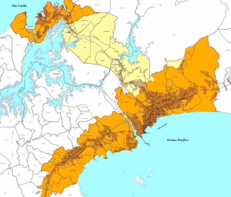
Map 1: The Central Zone
In 2000, the first year of total independence, and in a context of enduring dependence on the
canal, the Free Trade Zone and the Financial Centre, a single economic model was required: it
would need to meet global logistics demand in a time of growing trade volumes and strong
growth in Asian trade (20% of Chinese trade passes through Panama), while also
accommodating the new demand from the countries of Latin America.
Panama's strategy has been to do more than simply profit from the safe transit of global trade
by implementing more diversified forms of economic development. The privatization of ports
after 1996 enabled the creation, by global operators, of new port facilities in both Colón and
Panama City. The Panama Canal Authority has generated the means to match its ambitions by
improving shipping, raising toll prices and working on the vast construction project of the 21st
century: the expansion of transit capacity for an estimated total cost of USD 5,2 billion, which
may eventually reach USD 7 billion. These projects send a strong message to the rest of the
trading world about the willingness of this small country to remain a great maritime route by
adapting the canal to the growth in shipping capacity4. Since 2000, the canal has remained a
very significant source of income, in the order of 8% of GDP and more than 15% of
government revenue.
Table 7: The tools of competition:
3
2800 companies representing a transaction volume (imports and exports) in the order of USD 20 billion
annually, or two thirds of Panamanian trade. The Colón Free Zone. Regional Economic Services. French
Embassy in Panama. September 2010.
4
The completion of this work is planned for 2014, or a century after the inauguration of the canal.
4Maritime Shipping
■ The canal first and foremost, under the management of the Panama Canal Authority
■ Improvement of shipping in the canal over the past 10 years
■ Expansion of the canal capacity
■ Ports on each ocean:
■ Creation of 3 ports in Colón (2nd-largest port in Latin America) and 2 ports in Panama
City
■ Container storage areas and cruise ship terminals on both oceans
■ Logistics clusters:
■ Global maritime transit operators
■ Services to vessels, ship maintenance, fuel sales
Insurance, shipping agencies, registration of vessels
The development of all transport and communications links
▪ Road, freeway and railway links between the two ports
▪ Air links, fiber optic network, oil pipeline
ACD
The consequences of this restructuring of activities are transforming the central zone, which is
becoming an ever more complex and global demand-responsive logistics platform5. Within
the zone, on the last of the military lands, like the former compound and military airport of
Howard Air Force Base, there remain a number of world-class sites that are available for
current and future public and private investment in modern facilities. On the Pacific shore, at
the entry to the canal, the surface area available allows for the establishment of an airfreight
center, an aeronautical repair center, and an industrial port facility with a container yard (2
600 hectares) and an industrial free zone. The flagship of this new sector will be the
deepwater Megaport of Farfán (still to be excavated).
The approach is one of value-added logistics, that aims to reduce both the transit time and the
activity costs of logistics, due to the internationalization of the tertiary sector associated with
the diversification of the value harnessed by the canal's unique position. This position has
facilitated the growth of the airline COPA, which has developed Tocumen Airport into a high-
quality hub, with flights to every major city in North and South America. In November 2013,
Air France-KLM were developing several weekly flights to Panama, including 5 weekly
flights from Paris.
At a distance of 60km from each other, Panama City and Colón compliment each other more
than they compete with each other. The development of tertiary activities benefits from these
positive externalities. Commercial activities aimed at growing numbers of visitors and
residents are accommodated in vast shopping malls in the two cities. These malls are
connected to the shopping tourism generated by the business world and international tourism.
This new activity has introduced into Panama a Latin American clientele who formerly would
5
Les grands ports mondiaux [Great Ports of the World]. Questions internationales, La Documentation Française.
Paris 2014
5have travelled to Miami for their purchases and some services. The malls also benefit from
the boom in the Caribbean cruise industry. Thousands of visitors disembark, mostly in Colón,
due to the growth of tourism in the Caribbean.
Furthermore, specialization in the financial and decision-making fields is deepening in
Panama City due to the presence of the CFI and the head offices of companies, more and
more of whom are choosing this natural platform for exchange between two oceans, between
the American East and West Coasts, and between Asia and Europe. The arrival of regional
head offices and international institutions has been made possible by attractive legal and tax
measures as well as the availability of land and buildings in the former American Canal Zone,
especially near the technology park at Ciudad del Saber (the former Fort Clayton) along the
canal. Recently, regional head offices for global companies like Sanofi-Aventis Panama,
Heineken, Samsung Electronics, DHL, Dell and agencies of international institutions such as
the UNDP, UNEP Regional Office, the OAS, UNICEF, AECI and CATHALAC6 have
established themselves there. In a competitive environment, the choice made by these
organizations sends a clear signal to other Latin American cities.
Have Panama City and Colón, in the wake of this internationalization process, embarked on a
process likely to render them "global cities",7 as the arrival of regional head offices for
multinational companies would suggest? While this may be so, the two cities taken together
do not, however, constitute a command center. The financial center, for example, acts only as
a receiver of capital flows, and its agencies are merely regional in scope.
Priority has been given to the international arena, the aim being to compete successfully
against close rivals situated around the world. The development of Panama as a metropolis is
not a product of its territorial base but is induced by the growing globalization of the
economy. In effect, current development is not linked to the regional dynamism of the nation
and its 1 200 000 inhabitants living outside of the central zone. However, the impacts thereof
are far from negligible, and affect the whole of the country.
The boom in the residential and tourism-related property market
The spectacular growth of the residential property market is a response to the strong messages
sent by public investment. It is also caused by the economy's shift to tertiary sectors.
Attracting new business activity has generated a need for offices and housing for international
executives as well as recent arrivals, such as the American retirees who are actively
encouraged to settle in this dynamic, tropical and safe country with good infrastructure. Tax
and administrative concessions are offered to these groups. The provision of security is
essential to sustaining this demand, as it is for the logistics and commercial sectors.
Over the last ten years, the cityscape has been profoundly marked by the new urbanization,
which emulates the international template. Several dozen towers of more than 45 storeys, 6 of
which are more than 300m in height, have risen above an urban fabric that is not very dense,
in addition to offering comfort, sea views and even a 'green' label. The city has abruptly shed
its provincial charm for the look worthy of cities in Asia, or an oil-rich state. "The new
architecture no longer considers the site or local residents; it is only interested in what is
6
L’essentiel d’un marché: Panama [Panama: the Quintessential Market]. Sous la direction de Michel Planque,
208p. UBIFRANCE 2010
7
P. Claval. Métropolisation et politique [Metropolization and Politics]. Coll. Géographie et cultures. Laboratoire
Espace et cultures. L’Harmattan 1997
6profitable, and the formal expression of efficiency it is supposed to represent; it is
monumental, often flashy, and its objective is unprecedented technical excellence (the highest
skyscraper, the most dematerialized building..." - and soon, the greenest8). The Financial
Tower, currently under construction, will reach the record height of 366m (427m with
antennas).
This private property sector is driven by the internationalization of the economics of
buildings, public works and materials, as well as the globalization of funding mechanisms,
services and networks (cable links, etc.). Regional agencies of global companies and
institutions have lately begun to choose Panama to engage with Latin American and Asian
subsidiaries and branch offices, in order to benefit from its business environment and well-
developed financial system. This architecture projects a symbol of their belonging to the
international system that legitimizes the entire city's success in the eyes of the world.
The process of tertiary specialization also entails some repercussions for the city's overall
urban style, in the development of office buildings resolutely international in appearance,
despite efforts to find a Panamanian style (the cruise ship terminals in Panama City and
Colón). Moreover, near the Canal Zone, it seems that a neo-American style has been retained,
thus reproducing the look of the tropical military camp of the 20th century.
In Colón or in Panama City, urban reconstruction is associated with a major expansion of the
built environment, building upwards to reach the heavens (and gain a sea view). The
reintegration of the American area has led to the successful recovery of port areas and derelict
military lands in the former Canal Zone over the past fifteen years or more. Still to be built is
the vast Panamá Pacífico project (1400 hectares - USD 705 million) and the Megaport of
Farfán, to be built on the grounds of the former Howard Air Force Base. Elsewhere, in the
city, the densification of inner-city suburbs is underway, especially through the partial
rehabilitation9 of the historic center (casco antiguo), but also beyond the business district and
the Paitilla peninsula. In Colón, rehabilitation of the old quarter is difficult, but it is no longer
possible to take this into account as much as in recent decades. Commercial property is also
highly visible in the cityscape, with vast shopping centers that greatly surpass the buying
power of Panamanian consumers.
In the two port cities, the middle and working classes find housing in extensive peripheral
estates, both planned and unplanned, that stretch along the Pan-American Highway and its
secondary roads. Hundreds of individual houses acquired through long-term credit occupy the
forests and farmlands closest to the road, only blocked here and there by protected areas, such
as the well-guarded perimeter of the Panama Canal Authority. Private property development
follows the model seen across Latin American cities, with an offer of houses for between
USD 40 000 and 100 000 through long-term loans. This is a response to housing demand that
also supports economic growth. In 2010, the construction sector accounted for 40 000 jobs
and 20 000 new homes. The housing shortfall is estimated to stand at 125 000, according to
8
Thierry Paquot, L’architecte, l’urbaniste et le citoyen [The Architect, the Urbanist and the Citizen].
L’urbanisation du monde, Manière de voir n° 114 p 26 à 30. Le monde diplomatique. Dec. 2010 janvier 2011
9
Anne Collin Delavaud, L’insertion du centre historique et de la zone urbaine du canal dans l’aire
métropolitaine de Panama [The Insertion of the Old Quarter and the urban Canal Zone into the metropolitan area
of Panama City] In Les nouvelles formes d’intervention dans les centres historiques d’Amérique latine.
L’Information géographique, SEDES, Paris, vol 70, juin 2006 p21-34
7the 2010-2014 Strategic Government Plan10. In July 2014, the Government launched a
nationwide project, 100% Basic Sanitation, and an urban renewal project in Colón involving
25 000 inhabitants, the construction of 5 000 housing units and a loan of USD 500 million
from the IDB.
The tourism boom is leaving an ever more visible impact on the central region and its
peripheral development, thanks to the implementation of a development policy and publicity
that has reinforced the country's image over the past decade.11 Both operators and individuals
benefit from the improvement in infrastructure brought about by the need for transport and
communications links between the two cities. Public investment is facilitating the
international sector's need for hotels and seaside resorts. The many protected parks12 and the
country's ecological diversity has supported a holiday accommodation industry across the
country, while the business accommodation industry is divided between different
neighborhoods of the two large cities. Cruise ship terminals have also been constructed in
both cities. Colón has become an important base for Caribbean cruises, which also offer a day
in Panama City, with a visit to the old quarter, the business district and a mall. The
construction of a scenic route has been planned between Howard and Campana and the
beaches beyond, which are an hour from the capital.
The metropolitan dynamic thus extends beyond the central region to include peripheral tourist
spaces that are linked to it. Infrastructure, water, sanitation and road-building projects -
extending even to extension-of-tenure projects for rural land (well overdue in Panama)
compete with a revitalization of territory via new local, or even regional, values. In 2007, the
World Bank and the Inter-American Development Bank lent USD 27 million for the
modernization of land management in the metropolitan region. Obsolete cadasters and the
lack of regularization in land ownership is a serious constraint on efficient management,
especially in the context of rapid modernization. Indeed, in 2006 out of 600 000 rural or urban
properties, only 216 000 were registered and 160 000 were recorded in the cadaster.
How does a new demand for spatial planning express itself in competition between territories
at the local, regional and international scale? The choice here is crucial, because the stakes are
high - even in such a small country13.
Towards new modes of articulation between the territories of the central region
The global logistics sector and transnational facilities greatly affect the central region by
promoting closer contact between the two port cities, and thereby creating a multimodal
logistics corridor between the two oceans. How do local institutions manage this global
demand in a space that is limited, as well as limited, and divided between two planning
entities?
Map 2: Metropolitan areas (MIVI)
10
Programa para el desarrollo de vivienda social en Centroamérica. And the new MIVIOT program,
Reconstrucción "y rehabilitación techos de la esperanza" for 5000 slum dwellings over 5 years
11
In 2012, more than 3 million tourist arrivals were recorded.
12
Panama has 50 protected areas, accounting for 34% of its territory. Costa Rica's 155 protected areas account
for 25,8% of its territory. (PNUD-SICAP 2002)
13
Anne Collin Delavaud, La région centrale du Panama, un nouvel espace mondial? [Panama's Central Region:
A New Global Space?] L’information géographique, SEDES, Paris, May 2011, 24 pages
8Each city is managed by a municipality (municipio) led by a mayor, elected every 5 years, and
a municipal council. In 1997, the central zone was divided into three sub-regions, in order to
improve the regulation of land uses; these were delineated and divided up into planning
sectors that even included special zones in which the conservation of natural resources was
prioritized. Panama City and Colón each belong to a devolved autonomous government, the
area metropolitana del Pacifico and the area metropolitana del Atlantico.
Each zone encompasses a number of different districts, which are themselves divided into
corregimientos. Despite the inequality in area between them, it was thought best to maintain
distinct management areas. For Colón, it seems that the challenge is to maintain independence
in order to avoid being enveloped by the capital.
The Urban Development Plan of the Ministry of Housing (MIVI) acknowledges a third sub-
region, considered to be a special zone of critical importance: la cuenca del canal de Panamá.
This region has no dominant city, but small bedroom communities where residents seek to
benefit from their position along the road between the two ports by gaining employment in
one or the other, less than an hour's travel in each direction. The Canal Authority Law grants
the Panama Canal Authority (PCA) the powers of control to restrict as far as possible the
urbanization of the inter-isthmus corridor. This preoccupation with a territory in a critical
situation implies the need for an approach different from that of a metropolitan sub-region.
What is required is the means of managing the maintenance, protection and conservation of
resources that affect the quality and quantity of water for canal operations. The deforestation
of the canal's catchment areas inhibits the movement of shipping, while also affecting urban
consumption, especially during dry periods (El Niño).
At the scale of the country, or even of Central America, the entirety of the two metropolitan
areas actually makes up a single 'metropolitan area'. This situation has implications for
intercommunal management. Each city acts as a center for its peripheral communes, and even
for linear built-up areas lining major roads, the Pan-American Highway and the inter-isthmus
route. Panama City-Colón is not exempt from the Latin American model of uncontrolled
urban growth, with its pressures on rural and periurban land, as well as on facilities and
infrastructure.
For a decade now, fast linkages have been an added value of the development of logistics.
The authorities have understood this, and have orientated public investment towards roads and
freeways crossing the central zone and circling the capital and Colón. Both now possess
bypasses. In the worldwide race between ports, avoiding lost time and accommodating multi-
modality remain key priorities. However, for a variety of reasons, rapid connections between
the two cities are only now being achieved. A work stoppage lasting more than ten years
rendered the junction with the saturated inter-isthmus road difficult.
Access to Arraiján, La Chorrera and the North is provided by two bridges over the canal; the
second (Centenary Bridge) was built in 2006 near the first (Bridge of the Americas), built in
1962. The capital was provided with a coastal highway in 2010: the cinta costera extends
across the bay and is partially constructed on piles. This 7,5km route links the airport to the
business district, with a contested project (not carried out) for a route under the historic center
that would emerge onto the canal. Still to be achieved is the creation of a connection between
Howard and the bridges over the canal, the finalization of the Northern corridor and, to the
South, the connection of the airport at Tocumen with the freight terminal. Since 2012,
9connections between the residential districts and workplaces have been improved by the
Panama Metro, a 14km bus route in segregated lanes14, the second phase of which will extend
for 21km and is currently out to tender.
The Panama Financial Tower (69 floors) has been planned along this new route through the
Calidonia neighborhood (dating from the early 20th century). A third of the Tower will be
devoted to numerous state entities related to the financial sector, such as the Banco Nacional.
A hotel with 172 rooms is also planned, with a shopping center and some office space. The
cost of the Tower is estimated at USD 220 million.
The need for environmental governance at the metropolitan level
Environmental issues remain an area of concern, with the land pressure exerted on forested
areas or farmlands, and on mangroves. Urbanization at the periphery of Panama City and
Colón is absorbing cultivated lands, forested areas and older urban centers. Meanwhile, a
degree of land invasions have occurred in protected areas 15, albeit on a limited scale.
Currently, the Panama Canal Authority has the entire area dedicated to canal shipping firmly
under control. This includes the areas surrounding it, which were wisely declared protected
spaces more than 20 years ago.
The new road infrastructure passes through the protected areas, and even the beaches. While
Panama has thus for several years played the protection card at the national level, it would
appear that the urban response is less stringent. The towns of the central region have been
subject to an overly rapid urbanization, and are seeking to meet the demand for urban services
by the fastest means possible. The events which took place in January 2011 in connection
with potable water are a reminder of the fragility of this city and its global aspirations.
The 'Una gran ciudad' objective first appeared in the law on urbanism of 2009, which set out
new standards (Dirección de la Planificación urbana). Law 6 of 2006 had already presented a
new regulatory framework for spatial planning and, in particular, for the facilitation of
harmonious growth of the cities, such that the common interest was privileged over the
private. The concept of the eco-neighborhood appeared for the first time with Panamá
Pacífico, a green residential area of 1400 hectares. The towers on the coast and in the business
district claim to be green. But what is the reality of the ambitions which are, for the moment,
proffered to the wealthiest clients? The Ciudad del Saber, a technology and institutional hub
since 2011, has a plan for the integrated management of recyclable solid wastes.
The Pacific coast experiences relative drought conditions in normal years, which become
severe during El Niño periods. The competition between urban demand and the water needed
for transit through the locks is sometimes fierce. Tackling the freshwater issue is a core part of
the canal expansion project, along with the raising of the water level in Lake Gatún and the
partial recuperation of water from the locks for swimming pools. It is thus apparent that
management at the metropolitan level is necessary in such a limited area.
The same applies to energy demand, which is rising by 5-6% annually, necessitating an
expansion of capacity from 30 MW to 40 MW. Electricity generation and distribution are
14
A project involving Alstom
15 15
A. Collin Delavaud, L’intégration de la zone américaine dans l’aménagement urbain actuel de la ville de
Panama [The integration of the American Zone into the current spatial planning of Panama City]. Géocarrefour
n°79, 3, 2004, Lyon p247-256
10privatized, although electricity transmission is the responsibility of the state. ETESA, a public
company, has nearly completed construction of a parallel line of 400km. Furthermore, the
country has been connected to the SIEPAC Network (the Puebla-Panama Plan), of which a
140km stretch lies within Panama.
The cleanup of the Panama Bay area, under consideration since 1992, reflects the confusion
of roles of the different actors involved, and the inefficiency of the institution in charge. A
number of ministries and organizations, as well as donors (the IBD) have struggled to agree
on the proposals16. This situation is delaying the works and prolonging unhygienic conditions
that are in contrast with the new discourse of green urbanism which is advocated for the
building sites of the 'green' skyscrapers emerging along the coast. The rubble from these finds
its way to the Cerro Patacones, near the canal and Panama City. The seaside resorts are
pushed back by a few dozen kilometers.
Which metropolitan model?
After having invested heavily in new sectors such as logistics, tourism, finance and even
agriculture, it is interesting to note that public investment, after the era of 'todo sea por el
desarrollo economico', is turning today towards non-production sectors. This neglect or delay
may, in contrast, damage or slow the overall boom and harm the outlook for growth. As in
many other parts of the world, this economic model faces a set of unresolved social and
environmental issues, exacerbated by dependence on global operations that introduce much
uncertainty into the future. The crisis of 2008 did not spare the country, which saw its
productive sectors decline. The crisis has demonstrated in stark terms the question of the
sustainable development model followed by Panama, and its capacity to benefit from its
position in order to win the social and quality-of-life battle in the central region.
Overly rapid growth without development, starting from a base that is socio-economically
backward, provokes more rejection and crisis than would be caused by acquiescence to the
global project, which has hitherto benefited only certain sectors of the metropolitan area. The
five-year Strategic Government Plan (2010-2014) allocated USD 3,8 billion (out of USD 9,6
billion) for social infrastructure (schools, hospitals, social housing, sanitation, water and the
Panama Metro) across the country as a whole. The remaining USD 5,8 billion will be
allocated towards irrigation, tourism, the cold chain and the interconnection of road networks
within Panama City. An administrative complex, an arts complex and a convention center are
among the other major projects.
The model of uncontrolled expansion of the last 50 years in the cities of Latin America, based
on a sectoral vision of planning that is more facile than the global approach, is reproducing
itself here, and thereby precluding the possibility of closing the basic infrastructure gap.
The frankest terms come to mind when one attempts to describe the turbulence of urban
change in the central and Southern coastal neighborhoods: urban barbarism, chaos, and
anarchy in a context of real estate speculation and in the absence of municipal regulation.
Everything has been rejected: densification and sprawl, the two classical processes that define
the contemporary urban dynamic. Both are excessive. The flow of traffic and parking in an
urban model dominated by the private motor vehicle destroy, in advance, any future prospect
16
Either release into the open sea, after basic treatment, at a cost of USD 160 million, or full recycling (at a
treatment centre) for USD 350 million. Completion of the first phase is planned for 2017.
11of the high-quality urban lifestyle that the chosen architectural modes might bring. The towers
of the coast and the business district make a show of being 'green'. But what is the reality of
these ambitions, which - for the moment - are offered to the wealthiest clients? Estates of
(fairly charming) single homes, sprawling along the periphery, offer hopes of a better future
that will be dashed against the rocks of isolation and remoteness.
Regulatory intervention at the end of the 1990s came late, with the Regulatory Plan for Land
Use in the Metropolitan Area and the Ceded Areas administered by three authorities: the
Ministry of Housing (MIVI), the Panama City Municipality and the Interoceanic Regional
Authority (ARI). The latter had a temporary objective, now complete: cadastral registration
and sale of land in the former American zone.
The Municipality has a weak responsibility for the provision of services, and a limited
capacity to collect resources. Local governance suffers from confusion between the
competencies of different spheres of the administration (corregimientos and juntas vecinales),
as it is at the municipal, district, provincial and national levels. As for the metropolitan level,
it is weak due to the absence of governance mechanisms.
Law 106 on municipal affairs advocates the involvement of civil society. Promoting dialogue
between the different stakeholders in the municipalities and districts of the Panama City and
Colón metropolitan areas is urgently needed in order to move beyond the (often overly
radical) emergency urbanism. If, little by little, standards are being established, how much
will a given property development have benefited from infringements of the law?
Thanks to the synergy and dependence of activities, the emerging metropolization is
increasingly consolidating itself around a bipolar urban system. It these poles which, while
facilitating globalization, have integrated the territory into a creative dynamism. The
momentum of several business sectors have created jobs (including 35 000 for the expansion
of the canal) and reduced unemployment from 13% to 5,6% in the last five years, falling to a
possible 2,9% in 2014. The poverty rate has likewise fallen from 30% of the population in
2010 to 20% in 2020.
Conclusion
As a vital component of the global economy, Panama is experiencing new mobilities and
dependencies which have changed the scale and the landscape of Panama City and Colón.
They are with every passing day growing more interconnected, more sprawling, more
polycentric and more complementary; they are like conjoined twins in a sphere of activity that
is dependent on the rest of the world. Binary by necessity, Panama is like a country with a
vast hinterland between two shores facing two distinct oceans, except that here, everything is
reduced in scale, since only 60km separates the two cities, the two ports, and the two ocean
gateways. Maintaining economic competiveness was well served by the expansion of the
canal. However, what is still to be achieved it the improvement of the territorial context
around metropolitan area with two bridgeheads, as Panama's geography and current
development demand.
At the scale of a Latin American metropolis which sprawls over more than 70km, this
situation attends the commencement of a metropolitan process of absorption of all high-
quality spaces and of very different activities. Urban and logistics projects of the last few
12years are the beginnings of the process of construction of a metropolis dedicated to the
international sphere and surpassing the local and regional sphere.
The challenge has hitherto been, for each port city, to maintain its municipal prerogatives -
important in an ever-more cosmopolitan context - while also developing international
business. The modest size of the entire area should not distract from the public and private
will to reinforce traditional local authority that is close to the decision-makers, while also
invoking the idea of the metropolitan area. The shift in scale is a slow one. Governance does
not shift easily from the municipality to the region while the entirety of the cities and
countryside of the central zone are already responding to global demand. This contradiction
between a private sector fully dedicated to the international sphere, a territory and a very
powerful authority (the PCA) premised on the canal, and urban spaces in the midst of a deep
transformation, raises a question of identity, as ever more numerous international inhabitants
appropriate parts of a transformed landscape.
For the decision-makers, much remains to be done if an integrated regional system is to be
implemented. It is precisely there that the major governance challenge lies - working across
different scales to manage the discrepancy between economic success at the global level, and
social demand in the central zone and in the rest of the country. However, the economic
resources gleaned form this internationalization, so sorely lacking in neighboring countries,
could well change the game. For Panama, it's an opportunity to be seized.
Key words: Globalization, canal, Americas, port, planning, metropolization, investment,
Panama, Colón, environment
Abstract: Beyond the consolidation of its international role as a transit point, Panama's central
region is diversifying by creating a dual port system and by developing services - particularly
in the financial and commercial fields. The authorities also promote tourism and extend a
warm welcome to investors through a property boom and the arrival of regional head offices.
This functional internationalization is reflected in a strong metropolization of the spaces of the
central region around the two cities of Panama City and Colón, resulting in a metropolitan
area with two centers and an international outlook.
Mots clés : Mondialisation, canal, Amériques, port, aménagement, métropolisation,
investissements, Panama, Colon, environnement
Résumé : Au-delà de la consolidation de sa vocation internationale de transit, la région
centrale de Panama se diversifie en créant un double système portuaire et en développant les
services logistiques, bancaires et commerciaux. Les autorités jouent aussi la carte du tourisme
et créé les meilleures conditions d’accueil des investisseurs avec le boom immobilier et
l’installation de sièges sociaux régionaux. Cette internationalisation fonctionnelle se traduit
par une métropolisation très forte des territoires de la région centrale autour des deux villes de
Panama et de Colon formant un pôle métropolitain à deux têtes à vocation mondiale.
13Panamá o la aparición de una metrópoli global.
Resumen : Además de la consolidación de su vocación internacional de tránsito de la región
central de Panamá se diversifica mediante la creación de un sistema de doble puerto y el
desarrollo de servicios, en particular la banca y el comercio. Las autoridades también juegan
el mapa del turismo y crearon los mejores inversores de bienvenida con el auge de la vivienda
y la instalación de la sede regional. Esta internacionalización funcional se refleja en una muy
fuerte territorios metropolización de la región central alrededor de las dos ciudades de Panamá
y Colón la formación de un centro metropolitano con dos cabezas vocación global.
Plabras claves : Américas, Panamá, Colón , globalización, el canal, desarrollo portuario,
inversiones, metropolización, , medio ambiente
Map 1: The Central Zone
14Map 2: The metropolitan areas (MIVI)
15You can also read