Pervasive and Mobile Computing - CNR
←
→
Page content transcription
If your browser does not render page correctly, please read the page content below
Pervasive and Mobile Computing 67 (2020) 101225

                                                        Contents lists available at ScienceDirect

                                              Pervasive and Mobile Computing
                                                  journal homepage: www.elsevier.com/locate/pmc

Towards better social crisis data with HERMES: Hybrid sensing
for EmeRgency ManagEment System
                                                                                                                               ∗
Marco Avvenuti a , Salvatore Bellomo b , Stefano Cresci b , Leonardo Nizzoli a,b , ,
Maurizio Tesconi b
a
    Department of Information Engineering, University of Pisa, Italy
b
    Institute of Informatics and Telematics, National Research Council (IIT-CNR), Italy

article                 info                            a b s t r a c t

Article history:                                        People involved in mass emergencies increasingly publish information-rich contents in
Received 30 October 2019                                Online Social Networks (OSNs), thus acting as a distributed and resilient network of
Received in revised form 25 May 2020                    human sensors. In this work we present HERMES, a system designed to enrich the
Accepted 20 July 2020
                                                        information spontaneously disclosed by OSN users in the aftermath of disasters. HERMES
Available online 25 July 2020
                                                        leverages a mixed data collection strategy, called hybrid sensing, and state-of-the-art AI
Keywords:                                               techniques. Evaluated in real-world emergencies, HERMES proved to increase: (i) the
Human-as-a-sensor                                       amount of the available damage information; (ii) the density (up to 7×) and the variety
Hybrid sensing                                          (up to 18×) of the retrieved geographic information; (iii) the geographic coverage (up
Artificial intelligence                                 to 30%) and granularity.
Emergency management                                                                                       © 2020 Elsevier B.V. All rights reserved.
Online social networks

1. Introduction

   The recent proliferation of mobile devices, equipped with a large array of sensors and communication capabilities, has
established the so called Cyber–Physical convergence. In this high-tech scenario, information flows in a loop between the
physical and the cyber worlds, mediated by human activities [1–3]. At the same time, the mass diffusion and availability of
Online Social Networks (OSNs) has appointed them as the preferred supplier of information and communication services,
especially during fast-paced, unfolding events that impose stringent time requirements [4]. Crises and disasters are among
such events and, indeed, many people involved in disasters publish information-rich textual and multimedia messages in
OSNs, such as Facebook and Twitter, often live and in situ [5–9].
   The conjunction between the Cyber–Physical convergence and the rise of OSNs significantly extends, complements,
and possibly substitutes, conventional sensing by enabling the collection of data through networks of humans. These
unprecedented sharing and sensing opportunities have enabled situations where individuals not only play the role of
sensor operators, but also act as data sources themselves, thus implementing the so-called Human-as-a-Sensor paradigm.
This spontaneous behavior has driven a new thriving – yet challenging – research field, called social sensing, investigating
how human-sourced data can be gathered and used to gain situational awareness in a number of socially relevant
domains [10]. Depending on their awareness and their involvement in the system, ‘‘human sensors’’ are faced with either
opportunistic sensing, where users spontaneously collect and share data that is transparently intercepted by a situation-
aware system — or with participatory sensing, where users consciously meet an application request out of their own
will [11].

    ∗ Corresponding author at: Institute of Informatics and Telematics, National Research Council (IIT-CNR), Italy.
     E-mail addresses: marco.avvenuti@unipi.it (M. Avvenuti), s.bellomo@iit.cnr.it (S. Bellomo), s.cresci@iit.cnr.it (S. Cresci), l.nizzoli@iit.cnr.it
(L. Nizzoli), m.tesconi@iit.cnr.it (M. Tesconi).

https://doi.org/10.1016/j.pmcj.2020.101225
1574-1192/© 2020 Elsevier B.V. All rights reserved.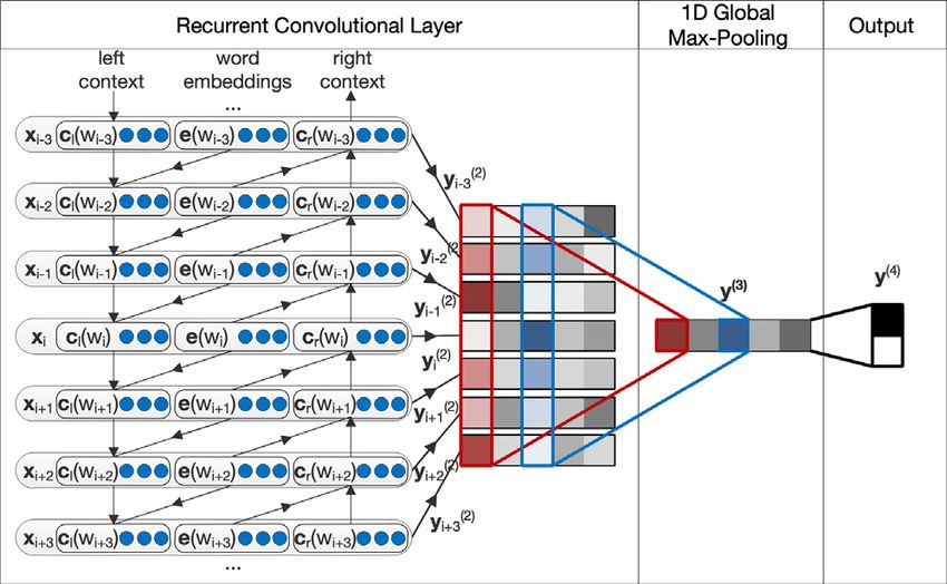
2                       M. Avvenuti, S. Bellomo, S. Cresci et al. / Pervasive and Mobile Computing 67 (2020) 101225

   Challengingly, relevant information in OSNs is typically unstructured, heterogeneous and fragmented over a large
number of messages, in such a way that it cannot be directly used. Hence, a number of AI techniques have been
developed in order to turn that messy data into a small set of actionable, clear and concise messages [12,13]. In the
aftermath of mass-disasters, AI techniques are adopted to automatically process large-scale crisis data, in an effort to
help tracking stricken locations, assessing the damage, coordinating the rescue efforts, and ultimately contributing to
make communities stronger and more resilient [5,14–17]. Until now, these techniques have almost solely fed on those
messages spontaneously shared in OSNs — that is, by exclusively following an opportunistic sensing approach [18]. In other
words, in the last years we have mainly looked for ways for improving the AI techniques that make sense of social crisis
data. However in sensing and in AI, better results are not only achieved via better algorithms, but also and foremost via
more and better data [19,20]. Yet to date, almost no effort has been made towards developing sensing and computational
methods for enriching available data in the first place — e.g., by soliciting additional information from people directly
involved in disasters.

1.1. Contributions

    Following an orthogonal approach to previous endeavours in the fields of human sensing and AI for disaster
management, we propose HERMES, a system for enriching available OSN data in the aftermath of disasters. HERMES
automatically complements data, spontaneously published and collected via opportunistic sensing, with targeted solicited
data, collected via participatory sensing. At a glance, the system listens to an OSN stream of messages related to a disaster.
Then, it leverages AI techniques to select a subset of relevant OSN users directly involved in the disaster, from which to
solicit additional information. Finally, it automatically asks targeted questions to selected users thus allowing to meet
the information needs of Emergency Operation Centers (EOCs), and it collects answers to those questions in real-time.
By analyzing data collected by HERMES, we empirically demonstrate that such messages contain richer information with
respect to those shared spontaneously (i.e., those typically used in previous works). Detailed contributions are summarized
in the following:

    • We design a novel sensing system, called HERMES, that implements the Human-as-a-Sensor paradigm and that
      exploits state-of-the-art AI techniques. By leveraging a hybrid sensing strategy, HERMES allows to combine the
      strengths of both opportunistic and participatory sensing.
    • We experiment with HERMES in a practically relevant scenario – such as emergency management – demonstrating
      its usefulness towards the acquisition of more and better crisis data from human sensors.
    • We report the results of an extensive, real-world experimentation, during which we monitored 436 worldwide
      earthquakes. Our results show that HERMES allowed to increase the amount of the retrieved damage information;
      the density (up to 7×) and the variety (up to 18×) of the retrieved geographic information, and the geographic
      coverage (up to 30%) and granularity;
    • We compare the results obtained by HERMES with those of the well-established USGS service ‘‘Did you feel it?’’
      (DYFI). We demonstrate HERMES capability in engaging a remarkably larger amount of contributors, with respect to
      USGS-DYFI, when considering earthquakes occurring outside of the U.S. and having little media coverage.
   Notably, HERMES leverages the Cyber–Physical information flow at its whole extent, embodying the paradigm of
Cyber–Physical systems with humans-in-the-loop.

1.2. Roadmap

    The remainder of this paper is organized as follows. The upcoming Section 2 surveys relevant works in the fields
of human sensing and AI for disaster management. In Section 3 we design our proposed HERMES system; we describe
its AI-powered logical components, and we reason about its possible legal and ethical implications. Then, in Section 4
we report and discuss results from the real-world experimentation campaign, and we compare our results with those of
USGS-DYFI. Finally, Section 5 draws conclusions and describes favorable avenues for future research and experimentation.

2. Related work in human sensing and AI for disaster management

    Among the tasks typically performed to make sense of social crisis data, there are: message filtering, message
classification according to the information conveyed, ranking of most relevant messages, aggregation and summarization
of information, and extraction of relevant information mentioned in messages (i.e., people, places and objects involved in
the disaster) [13]. These low-level tasks are usually carried out as part of more complex analyses, performed to achieve
high-level goals such as increasing the overall situational awareness during a crisis, or maintaining an updated crisis map
of the stricken area [5,21]. Given the focus of our work, in this section we briefly survey previous solutions to the tasks
of message filtering, message classification and information extraction, with the specific goal of producing crisis maps. A
broader survey of recent literature can be accessed in [13] and references therein.
    Regarding message filtering and classification, the majority of existing approaches rely on natural language processing
techniques [22–24]. The task of message filtering is typically tackled with a binary classifier that labels messages as either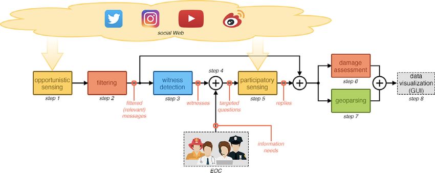
M. Avvenuti, S. Bellomo, S. Cresci et al. / Pervasive and Mobile Computing 67 (2020) 101225         3

                      Fig. 1. System architecture of HERMES, a Hybrid sensing for EmeRgency ManagEment System.

relevant or irrelevant. Instead, message classification can take many different forms, according to the type of collected
data and the goals of the analysis. For instance, authors of [23] classified messages as either conveying useful information
for a damage assessment task or not. Other authors learned binary, multi-class, and multi-label classifiers for a wider
set of goals, such as for identifying messages posted by witness and non-witness users [22,24], and messages conveying
different types of information (e.g., cautions and advice, casualties and damage, donations) [22]. Conversely, a different
approach to message classification is employed in the AIDR system [25], where both human and machine intelligence are
simultaneously employed for carrying out high-quality classification tasks in real-time.
    Concerning information extraction, among the most useful information in the aftermath of a disaster are geographic
references. The crucial importance of geospatial information, combined with the negligible number of messages that
natively carry such information [26], resulted in many attempts to perform automatic geoparsing and geotagging of OSN
data [13,27]. Traditional approaches to geoparsing relied on pattern matching of message tokens against gazetteer data,
or on named entity extraction and classification [5]. Instead, more recent approaches adopted powerful AI algorithms
for classification and semantic annotation, probabilistic language models and representations of structured information
contained in knowledge graphs [26,28].
    Finally, relevant information obtained via message classification or information extraction, is often leveraged to
produce and update crisis maps, allowing the visualization of most relevant information about an event on a map [13].
State-of-the-art systems produce crisis maps by comparing the volume of messages that mention given locations with
statistical baselines [5], or by highlighting regions of space for which the system collected a significantly high number of
damage-related information [29,30].
    All works surveyed in this section are solely based on spontaneous user messages, opportunistically collected. As such,
all these works could potentially benefit from a data collection strategy such as the one that we are proposing.

3. HERMES: Hybrid sensing for EmeRgency ManagEment system

   In this section, we describe the high-level architecture of HERMES, a novel and fully-automatic emergency management
system. HERMES combines state-of-the-art AI techniques for message filtering, damage assessment, geoparsing and
witness detection with a hybrid approach to sensing, taking advantage of both spontaneous and solicited information
disclosed by OSN users. A schema of the proposed system architecture is depicted in Fig. 1, whereas Fig. 2 shows a
temporal diagram of its functioning according to the Unified Modeling Language (UML) visualization approach. In the
current implementation, HERMES focuses on earthquake emergency relief. Hence, its functioning is triggered by notifica-
tions automatically issued by the United States Geological Survey (USGS) whenever an earthquake occurs. However, we
emphasize that our proposed approach can be easily generalized to other types of both natural and man-made crises such
as floods, landslides as well as riots and terrorist attacks.
   Once triggered, HERMES performs the following steps:

   1. it collects spontaneous user messages, based on metadata or specific keywords (opportunistic sensing);
   2. it filters out noise in order to retain only relevant messages, by means of a dedicated deep learning text classifier
      (filtering);
   3. it selects a subset of users to be contacted in the participatory phase, leveraging a state-of-the-art witness detection
      classifier based on a rich set of features extracted from text and user metadata (witness detection);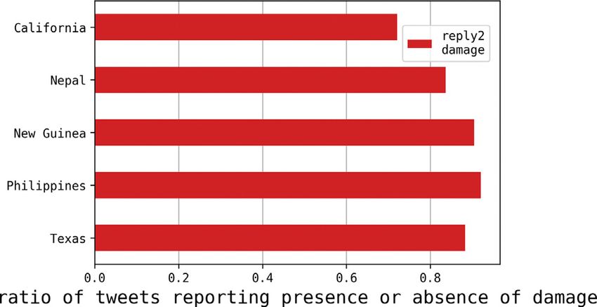
4                          M. Avvenuti, S. Bellomo, S. Cresci et al. / Pervasive and Mobile Computing 67 (2020) 101225

Fig. 2. UML sequence diagram of the HERMES system. ∆t represents the latency between the sending of our targeted questions and the possible
user replies.

    4. it eventually collects specific information needs from the involved EOC personnel;
    5. it asks a set of targeted questions to selected users, leveraging benign social media bots, and it collects user replies
       (participatory sensing);
    6. it filters messages including information about damages to people or infrastructures, by means of a deep learning
       text classifier (damage assessment);
    7. it enriches messages with geographic information, leveraging a state-of-the-art geoparsing tool, thus tagging
       messages with the corresponding geographic coordinates (geoparsing).

   The retrieved data can be aggregated and visually summarized by means of information and data visualization
techniques, as indicated by the last step of Fig. 1 (data visualization). However, data visualization is out of the scope
of this paper. Hence, we just provide crisis mapping as an example of a possible outcome, enabling to highlight those
geographic regions that are likely to have suffered higher damage in order to prioritize possible responses [5,29].
   The previously described steps emphasize a strong interplay between our hybrid sensing strategy and the AI techniques
leveraged by our system. In particular, the AI techniques not only provide HERMES with the ability to automatically filter,
assess and enrich the contents retrieved from the OSNs, but they directly lead the data gathering during the participatory
phase of the hybrid sensing strategy. In fact, they contribute to select which users to contact, targeting them with pertinent
questions. Ultimately, the novelty of the HERMES system does not lie in its individual components, but in the peculiar
combination of AI and sensing techniques, that has never been proposed and investigated before, to the best of our
knowledge. In the remainder, in each separate subsection we provide in-depth description and technical details about
each logical component of the system.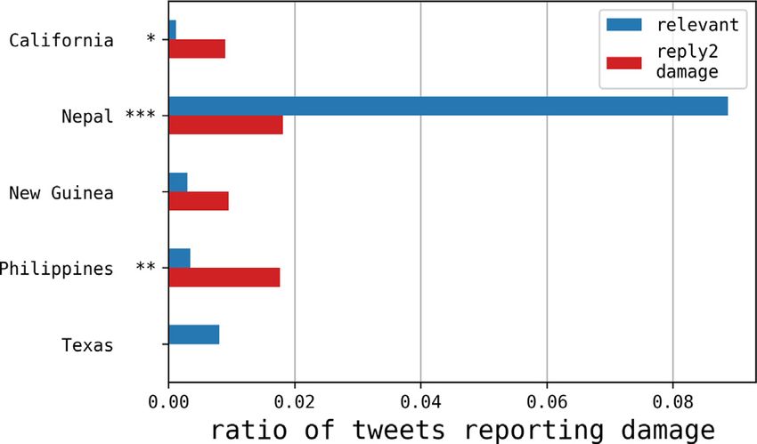
M. Avvenuti, S. Bellomo, S. Cresci et al. / Pervasive and Mobile Computing 67 (2020) 101225          5

3.1. Hybrid sensing

    Concerning data acquisition, HERMES implements an hybrid sensing approach, a novel social media-based paradigm
that we designed in order to combine the strengths of both opportunistic and participatory sensing [31].
    In a nutshell, the opportunistic sensing phase consists of transparently intercepting data collected and disclosed by
users in their unsolicited, spontaneous activities on the OSNs. To do so, the system leverages the filtering features typically
provided by the OSN platforms themselves (e.g., keyword-based filtering), and it extracts and enriches the available,
relevant information thanks to dedicated, AI-powered techniques. Conversely, the participatory sensing phase involves
contacting selected users to solicit more specific and detailed information. Also in this case, dedicated AI techniques
enable the system to automatically identify the most valuable users to contact, among those intercepted during the
opportunistic sensing phase. Hence, the hybrid sensing approach goes beyond traditional event detection and collection
of initial comments – achievable by opportunistic sensing alone – up to a direct contact with users, that might have
experienced the event firsthand.
    In detail, after having received the notification of an earthquake occurrence from USGS, HERMES initiates the
opportunistic phase (step 1 of Fig. 1) by crawling one or more social media in order to collect spontaneous, event-related
messages, based on specific keywords or metadata. Opportunistic sensing has a twofold goal: (i) to figure out, as fast as
possible, preliminary situational information, and (ii) to create a list of possible witnesses to solicit for additional, more
focused and detailed information during the subsequent participatory phase (step 5 of Fig. 1). In the participatory sensing
phase, benign social media bots automatically ask targeted questions to selected users. Dedicated social media crawlers
collect possible answers to these questions. In Fig. 2, ∆t represents the latency between the sending of our targeted
questions and the possible user replies. Latency has a decisive importance for the applicability of our approach, since
enabling timely responses can make the difference during emergencies.
    The type of engagement questions sent to witnesses depends on the content of the messages they initially posted and
on specific information goals of EOCs. For example, users that sent geolocalized posts are asked about experienced or
observed damage to people or infrastructures, while users that posted non-geolocalized posts may be asked to disclose
their geographic position. Henceforth, replies to the former type of questions will be labeled as reply2damage, whereas
replies to the latter will be labeled as reply2geo. As a politeness best practice, no user is contacted more than once.
    It is noteworthy to emphasize that implementing and experimenting with such a hybrid sensing system pose harsh
requirements in terms of time, effort and resources, thus jeopardizing the reproduction of experiments. The reason is
twofold. First, limitations introduced by the OSNs to regulate the access to their resources (e.g., rate limits imposed
on API endpoints) must be faced. Those limits can affect the opportunistic sensing phase, because the huge stream of
messages that is typically triggered by mass emergencies may require to deploy multiple crawlers and to refine the
filtering strategies in order to match the platform constraints. However, the most severe impact is on the participatory
phase, since social bot activities are rigorously restricted in order to prevent spam and deceptive behaviors [32]. Hence,
besides carefully selecting possible witnesses to contact, we have to deploy and orchestrate a sufficiently large botnet,
ensuring that each bot activity is compliant with the platform policies to avoid possible bans. Second, hybrid sensing is
triggered by the occurrence of earthquakes, signaled by the USGS notification service. Moreover, in order to cope with
the variety of scenarios that can occur in real applications, we need to test our system on a wide range of earthquake
magnitudes and intensities, and diverse epicenter locations, as well as accounting for the variance in urbanization, social
media diffusion and usage, and percentage of English speakers.

3.2. Message filtering and damage assessment

    As it typically happens in social media analysis, not all the messages collected with specific keywords are actually
relevant to the event under investigation. To overcome this issue, we perform message filtering (step 2 of Fig. 1) to retain
only relevant messages. We frame this task as a binary text classification. Presently, AI state-of-the-art for solving this task
is represented by Deep Learning, based on Artificial Neural Networks [33]. Its main advantages over traditional machine
learning can be roughly resumed as:

   1. higher performance;
   2. text processed from scratch, with no need of previous feature extraction [34];
   3. a higher capability to adapt to other problems (i.e., transfer learning) or languages [35].
We consider two cascading tasks:

   1. to filter messages actually related to the monitored crisis event (relevant messages hereafter);
   2. to retrieve messages containing information about the occurrence, or the absence, of damages to people or
      infrastructures (damage messages hereafter).
   To implement filtering and damage assessment models, we rely on Recurrent Convolutional Neural Networks (RCNNs),
combined with max pooling and based on pre-trained word embeddings [36], adopting the architecture proposed in [37].
In [38], this architecture was proven to provide particularly good and stable performance under those very challenging
conditions, where an unknown but potentially high dataset imbalance is expected. That is, when we want to identify a
6                              M. Avvenuti, S. Bellomo, S. Cresci et al. / Pervasive and Mobile Computing 67 (2020) 101225

    Fig. 3. Architecture of the recurrent convolutional neural networks used to train the models for message filtering and damage assessment steps.

few pertinent messages hidden in a huge stream of noise. In Fig. 3, we provide a schema of the architecture. The learning
process includes two phases: (i) word representation and (ii) text representation learning. Word representation learning
consists in building, for each word wi , a representation of the form
         xi = [cl (wi ); e(wi ); cr (wi )]                                                                                                       (1)
where cl (wi ), cr (wi ) are vectors representing the left- and right-side contexts of the word. e(wi ) is the word representation
according to a word embeddings model, that is a continuous, distributional representation of words, pre-trained on
large text corpora [36]. The word representation phase is performed by the recurrent convolutional layer, based on a
Bidirectional Long–Short Term Memory (BLSTM) architecture, by means of a forward/backward text scan, respectively. The
                                                                      (2)
output of this layer are the so-called latent semantic vectors yi , obtained by applying a linear transformation together
with a tanh activation function to xi . Text representation learning starts with a 1D global max pooling layer. It is used to
                                                                               (2)
convert texts of various lengths into a fixed-sized vector y(3) = maxni=1 yi , capturing the most important latent semantic
                                                                                   (4)
factors of the document. The final dense layer obtains the output vector yi , to which a softmax activation function is
applied to compute the final output. In order to induce regularization effects and to contrast overfitting, we introduced
two dropout layers before and after the recurrent convolutional one, with 0.4, 0.3 dropout probabilities respectively.1
    For training and testing our model, we leverage CrisisNLP,2 an open source repository including annotated datasets
of tweets related to various types of crises [39]. The provided annotations allow to label those tweets according to the
binary class relevant/not relevant, suitable for the message filtering task. We assemble a single dataset by mixing up all
the available, earthquake-related, annotated datasets, and we obtain training (64%), validation (16%) and test (20%) sets
by applying a stratified sampling over the target class. The same repository includes also the Word2Vec embeddings,
trained using crisis-related tweets, that we use in our framework. For the message filtering task (step 2 of Fig. 1), our
model obtains an AUC = 0.87 (Area Under the ROC Curve), in line with the state-of-the-art [40]. Messages classified as
irrelevant are discarded and not used for further analysis. Hence, this classifier enables HERMES to retain only messages
actually pertinent to the monitored earthquake for further analysis.
    The same approach used for filtering messages is also adopted to train a damage assessment classifier (step 6 of Fig. 1).
This time, we label the tweets according to the target class presence/absence of damage information. The classifier is able
to detect messages that convey information about the presence of damage to people or infrastructures, reporting a state-
of-the-art AUC = 0.89. Thanks to this model, HERMES can provide EOC personnel with fine-grained information about
damages, and it can assess the earthquake impact.

3.3. Witness detection

    One of the key components of the system (step 3 of Fig. 1) is the AI module that selects, among all the users that posted
event-related messages, the subset of those to be contacted in the participatory sensing phase. Selecting a subset of users
is necessary in order to comply with anti-spamming rules of OSNs, that typically impose upper bounds on the number of
messages that can be sent automatically.
    Users selection is based on the automatic witness detection system described in [24]. We cast witness detection as a
binary classification task. The classifier is based on a quadratic Support Vector Machine (SVM), implemented using the
LIBSVM framework [41]. The SVM operates on text data and user metadata, retrieved during opportunistic sensing. In
particular, it leverages 5 different classes of features:

    1 We refer to [37] for further mathematical details and the hyperparameter setting.
    2 http://crisisnlp.qcri.org/lrec2016/lrec2016.html.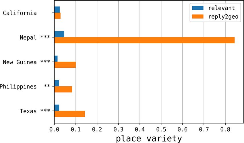
M. Avvenuti, S. Bellomo, S. Cresci et al. / Pervasive and Mobile Computing 67 (2020) 101225      7

   1. linguistic features, representing lexical (e.g., character n-grams, punctuation, etc.) and morpho-syntactic (e.g., Part-
      of-Speech n-grams) facets of the analyzed text;
   2. word embeddings, coping with the problem of sparsity of the previous lexical representations of short texts;
   3. sentiment polarity, tracking the emotional content and the degree of subjectivity of the text;
   4. semantic entity linking, enriching the text with semantic references to knowledge graph entities, and
   5. user metadata, accounting for message features like the adopted client, the geolocalization, and the posting
      timestamp.
Feature classes 1 and 2 are state-of-the-art, natural language processing approaches to model the text syntax, semantics
and writing style. Feature class 3 aims to track subjective and emphasized language frequently used by witnesses. Feature
class 4 augments the text semantic representation with rich, structured and inter-linked information. Feature class 5
accounts for details about the user behavior, or her temporal and spatial proximity to the event.
    We train and test our witness detector over a semi-automatically labeled dataset of witness tweets [24]. Results
computed with a 5-fold cross validation report a state-of-the-art F 1 = 0.85, obtained for messages classified with high
machine confidence scores [24]. The obtained witness detection model enables HERMES to select the most promising users
to contact during the participatory sensing phase. In this way, the system can obtain relevant, first-hand information while
coping with the severe OSN platform limitations on bot activities.

3.4. Geoparsing

    Geospatial analysis suffers from the fact that only a small fraction of OSN messages are natively geotagged [26]. For
instance, the ratio of geotagged Twitter messages is in the range of 1% to 4% [26], which indeed constitutes a severe
limitation. To increase the number of geotagged messages, we employ our geoparsing module (step 7 of Fig. 1), based on
Geo-Semantic-Parsing (GSP). As described in [26,28], GSP receives a text document as its input and returns an enriched
document where all mentions of places are associated to the corresponding geographic coordinates.
    First, semantic annotation is performed to identify relevant parts of the input text (anchors) that can be linked to
pertinent resources (e.g., DBpedia entities) in the Linked Data cloud. We perform semantic annotation leveraging the
state-of-the-art, off-the-shelf tool Tagme [42], specifically designed to work with short, poorly written texts, and thus being
particularly suitable for social media applications. Semantic annotation represents the key novelty of the GSP approach
over the state-of-the-art benchmarks. Its main advantage is represented by the ability of the semantic annotators to
leverage the information-rich, interlinked structure of the knowledge graphs to implicitly perform disambiguation. In
fact, toponymic polysemy represents the main limitation to traditional approaches based on named-entity recognition
and geographic gazetteer lookup.
    Then, GSP expands the available information by traversing the Linked Data, leveraging the Resource Description
Framework (RDF) properties. In particular, it retrieves resources semantically equivalent to those returned by Tagme,
but belonging to other knowledge graphs. At this point, a specific machine learning classifier, based on a Support Vector
Machine, prunes those resources that do not correspond to geographic locations. It leverages several, carefully crafted
features to measure the pertinence between the anchors and the corresponding semantic resources, and to assess the
likelihood that the semantic resources actually refer to geographic locations. To name just a few, these features include the
edit distance between the anchors and the semantic resource titles, the Part-of-Speech tags of the anchors, the ontology
classes of the semantic resources, and the number of occurrences of the anchors in the resource abstracts [26]. Finally,
GSP parses the relevant resources to extract the geographic coordinates, thus geotagging the related anchors.
    GSP has a number of advantages over other geoparsing approaches: (i) it does not require any explicit geographic
information (e.g., GPS coordinates, location information, time zones); (ii) it only exploits text data of input documents
(e.g., it does not require any user information or social network topology); (iii) it processes one text document at a time
(e.g., it does not require all tweets from a user’s timeline, or many documents on a given topic); (iv) it does not require
users to specify a target geographic region but, instead, it geoparses and geotags places all over the world; (v) by leveraging
Linked Data, GSP is capable of extracting fine-grained, structured geographic information (e.g., country → region → city
→ building).
    In [26,28], GSP was proved to largely outperform state-of-the-art benchmarks, reaching performance suitable for
realistic applications. Hence, GSP provides HERMES with the ability to identify and geotag toponyms mentioned by OSN
users, thus enabling useful applications like crisis mapping.

3.5. Legal and ethical considerations on the hybrid sensing approach

   The hybrid sensing approach of the HERMES system raises legal and ethical considerations, that always come with
social crisis data gathering. In fact, this effort is deployed when people are at their most vulnerable, disclosing personal
information on OSNs to seek help, update or trace back loved ones [43].
   From a legal point of view, the experimental campaigns conducted with HERMES on the Twitter platform accomplish
the legal requirement of the European General Data Protection Regulation (GDPR) in terms of personal data processing,
and the Twitter platform terms of use. In particular, the platform clearly informs users that ‘‘Twitter is public and Tweets
are immediately viewable and searchable by anyone around the world’’.3 Hence, provided that a proper treatment is

 3 https://twitter.com/en/privacy.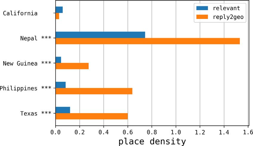
8                             M. Avvenuti, S. Bellomo, S. Cresci et al. / Pervasive and Mobile Computing 67 (2020) 101225

Table 1
Statistics about the top-5 earthquakes monitored by HERMES, and a comparison between the amount of users engaged by our system and those
contributing to the USGS-DYFI service for the same events.
    Place                   Magnitude    Depth    Date      Collected    Relevant     Collected   Collaborative Message     Reply        Participants
                                         (km)     (2015)    messages     messages     replies     replies       gain        latency ∆t   wrt
                                                                                                                            (min)        USGS-DYFI
    San Ramon, California   3.5          11       02/04       2,266       836         164         78%            +20%        5           4%
    Lila, Philippines       4.8          81       30/03       2,396       868         161         95%            +19%       11           215%
    Lamjung, Nepal          7.5          12       25/04     117,774      8,545        160         95%            +2%        24           15%
    Kokopo, Papua New       7.7          66       29/03      10,576       672         153         96%            +23%       28           1,958%
    Guinea
    Irving, Texas           3.3          6        02/04       2,044       620         132         87%            +21%        8           16%

guaranteed, data can be crawled without an explicit user consent. Moreover, during the participatory phase, the usage
of bots and the objectives of the campaign were made clear by the approach tweets and the automated account profile
information, and the solicited users consciously accepted to disclose personal data.
   However, compliance with the law does not solve ethical concerns per se, and the issue of informed consent is not the
end of the story. In fact, ‘‘even well informed and rational individuals cannot appropriately self-manage their privacy’’,
given the ability of big data approaches to aggregate multiple data sources to reveal more information [44]. This is an
open issue in social crisis data research [43]. On the one hand, the particular context of crisis may induce to reconsider
priorities, making acceptable some privacy leakage in exchange of a more effective and prompt response to the emergency,
which includes also contributing to a research effort aiming to provide better emergency management tools for future
events. On the other hand, a condition of higher people vulnerability should induce more effort in their privacy protection.
Solving this Hamletic dilemma is beyond the scope of this work. Our commitment was entirely devoted to guarantee a
proper, secure and anonymized data treatment.

4. Real-world experiment and results

   In this section, we present a thorough evaluation of HERMES, with the aim of assessing the effectiveness of our
approach in increasing the amount of social crisis data and enhancing the information conveyed. In particular, we evaluate
the intake of the participatory sensing phase, by comparing the amount and quality of the solicited replies with respect
to the opportunistically crawled messages. As already highlighted in Section 3.1, testing such a system is a complex
task, as it requires the capability of promptly involving real users during the unpredictable occurrence of earthquakes
of medium-to-high magnitude, while coping with the limitations imposed by the OSN platforms.

4.1. Increasing the amount of social crisis data

   We tested HERMES in-the-wild on Twitter by running a long-lived experiment lasting from February to May, 2015.
During the experiment, our system was triggered by USGS to monitor up to 436 earthquakes. In order to conveniently
report the experimental results, we introduce the following definitions:

      • collected messages: the tweets gathered through opportunistic sensing;
      • relevant messages: the tweets actually concerning the monitored earthquake, retained (i.e., not discarded) by the
          filtering module described in Section 3.2;
      •   collected replies: the messages received from users contacted in the participatory phase;
      •   collaborative replies: the percentage of collected replies containing valuable information;
      •   message gain: the ratio of collected replies to relevant messages;
      •   reply delay ∆t : the average latency of replies.
Table 1 shows the results from the top-5 earthquakes in terms of the number of collected replies, according to the
defined measures. These earthquakes occurred in different geographic areas, featuring diverse characteristics in terms
of demography, economy, urbanization and language. Moving the focus on the earthquake intensity, the examined range
spans from moderate events (California, Texas) to fatal disasters involving thousands of casualties (Nepal).
   The participatory component of HERMES was able to produce a remarkable message gain of about 20%. One notable
exception was the devastating Nepal earthquake, with a message gain of only 2% despite a number of replies comparable to
the other events. This result was mainly due to the limited amount of targeted questions allowed by the Twitter platform
during the participatory phase, compared to the large number of relevant messages collected during the opportunistic
phase. In any case, we envision the possibility to obtain similar message gains also for major events by deploying larger
botnets to cope with the platform limitations.
   Notably, most of the collected replies conveyed valuable information (collaborative replies). In detail, collaborative
replies range from 78% for the little California earthquake to more than 95% for all the three intense ones. These results
confirm a general tendency of users to collaborate, which appears to increase with the severity of the earthquake. In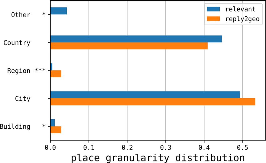
M. Avvenuti, S. Bellomo, S. Cresci et al. / Pervasive and Mobile Computing 67 (2020) 101225 9
Section 3.5, we emphasized that the user propensity to disclose personal information depends on the context. In fact,
severe earthquakes may induce users to accept potential privacy leakages (like those related to position disclosure) in
exchange of a more effective and prompt response to their needs during the emergency [43]. Results reported in Table 1
confirm this intuition.
The second-last column of Table 1 confirms that participatory sensing retrieved new information in a timely fashion,
with a reply latency ∆t ≤ 28 min. Similar results were already observed in [31], and they accomplish the need of a
prompt response to disasters.
Finally, in the last column of Table 1 we compare the amount of HERMES collaborative participants with respect
to those contributing to the USGS Did You Feel It? (DYFI)4 web service, for the same earthquake events. USGS-DYFI
requires users to spontaneously navigate to the corresponding web page and fill a questionnaire about their earthquake
experience. Results show that HERMES, despite being a newcomer, was able to engage far more users than a well-
established, institutional service like USGS-DYFI, when considering events occurring outside the U.S. and with poor media
coverage (Philippines and Papua New Guinea). Interestingly, in [45] authors demonstrated that the USGS-DYFI ability to
engage participants strongly depends on both the physical features of the earthquake (e.g., magnitude, depth) and the
demographic traits of the involved area. For example, the response rate increases with the percentage of English native
speakers, the education and the wealth of the population, whereas it decreases with the percentage of immigrants and
the median age. Hence, the capability of HERMES to directly contact witnesses proves crucial to engage users that are not
aware of services like USGS-DYFI. Moreover, people reluctance to participate in surveys – especially long and complex
ones – is well known in several domains [46–48]. This tendency is further confirmed by another experimental campaign
that we conducted in autumn 2016, when we monitored 626 earthquakes with magnitude >2.5 following a hybrid sensing
approach, similar to the one adopted in HERMES. However, in this case we targeted users with tweets inviting to follow
a link to a simple Web survey questionnaire. In the face of 2,384 approach tweets, we engaged only 75 participants,
corresponding to an unsatisfactory 3.1% response rate. As a consequence, the capability of HERMES to handle the whole
interaction with users on the same OSN platform appears as a key ingredient in order to engage less helpful or trustful
users, not willing to browse an external Web page to participate in a survey.
Since now, we described how HERMES can increase the amount of social crisis data, operating in an orthogonal and
complementary way with respect to services like USGS-DYFI, especially during emergencies affecting developing countries
or having poor media coverage. In the remainder of this section, we assess the amount and quality of the information
conveyed by the retrieved data.
4.2. Enhancing the information conveyed by social crisis data
In the previous Section, we demonstrated that the participatory sensing ensures a gain of about +20% in the amount of
available messages. Now, we focus on the content of the messages collected during the five earthquakes listed in Table 1.
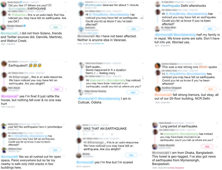
Figs. 4a–4e show some examples of the user replies to our targeted questions. In all the provided examples, the replies
solicited in the participatory phase integrated, increased or clarified the information conveyed by the original, spontaneous
tweet. In Fig. 4a, the user spontaneously signaled an earthquake, asking who felt it. From the reply to our question,
concerning her safety, we learned that the earthquake was not perceivable in the user location, but it was felt nearby.
The user in Fig. 4e reported an earthquake that she clearly felt without suffering consequences, but it was thanks to the
solicited reply that we could locate her. The original tweet of Fig. 4b signaled a one minute-long jolt affecting a large city,
but we could exclude serious consequences after the interaction with the user. While replies in Figs. 4d and 4h attested
different reactions from people involved in moderate events without serious consequences, the ones in Figs. 4f and 4g
described a situation where people ran out of buildings, with the latter tweet also reporting about damaged structures.
The propensity of people involved in severe events to actively collaborate with us is shown in Figs. 4c and 4i. In the first
one, we show the distressing testimony of a person tweeting from Delhi, who was worried about some relatives close to
the Nepal earthquake epicenter and not yet traced. In a real application, this kind of witness may be put in direct contact
with a first responder with mutual benefit. In the last one, we asked the position to a user reporting an earthquake. She
did not limit herself to reply specifying her location, but she had also the foresight of enabling the Twitter GPS geotagging
feature for providing her exact coordinates.
After this qualitative exploration of the collected replies, we proceed to their quantitative analysis. We want to compare
solicited replies to spontaneous messages in terms of the density, variety and granularity of the conveyed information.
We focus on damage assessment and geolocation, leveraging the dedicated modules described in sections 3.2, 3.4.
4.2.1. Damage assessment
HERMES enables a near real-time damage assessment in the aftermath of crisis events, by leveraging messages
reporting the presence of damage (or lack thereof) to people or infrastructures. Those messages are conveniently filtered
by the dedicated module described in Section 3.2, based on a state-of-the-art, deep learning text classifier.
We evaluated the system performance in retrieving damage-related information during the five earthquakes listed
in Table 1. Fig. 5 shows the ratio of tweets reporting damage information, distinguishing spontaneous tweets (relevant)
4 http://earthquake.usgs.gov/data/dyfi/.
10                           M. Avvenuti, S. Bellomo, S. Cresci et al. / Pervasive and Mobile Computing 67 (2020) 101225

Fig. 4. Examples of ‘‘conversations’’ with Twitter users. Conversations are composed of 3 tweets: (i) the topmost tweet is a spontaneous message
collected with opportunistic sensing; (ii) the middle tweet is the targeted question automatically sent by our system, and (iii) the bottom tweet is
the user reply to our question.

Fig. 5. Ratio of tweets reporting the presence of damage in solicited replies (reply2damage) with respect to spontaneous relevant tweets. Statistical
significance of comparisons is evaluated by means of T-tests, with ***: p < 0.01; **: p < 0.05; *: p < 0.1.

with respect to solicited replies to questions about the presence of damages (reply2damage). For harmless earthquakes,
there was a low percentage of damage-reporting tweets in spontaneous (relevant) messages. Notably, the percentage
significantly increased (up to 7×) when considering replies to our targeted questions (reply2damage). Focusing on
the destructive Nepal event, we found a relevant 9% of damage-reporting tweets in relevant messages, whereas for
reply2damage messages the fraction was less than 2%, in line with other events. This can be explained by the fact that
the majority of users was tweeting from surrounding countries (e.g., India) rather than from the epicenter area (cf.
M. Avvenuti, S. Bellomo, S. Cresci et al. / Pervasive and Mobile Computing 67 (2020) 101225                            11

               Fig. 6. Ratio of tweets reporting information about damage (presence or absence) in solicited replies (reply2damage).

Fig. 7. Place density per event for solicited replies (reply2geo) and spontaneous relevant tweets. Statistical significance of comparisons is evaluated
by means of T-tests, with ***: p < 0.01; **: p < 0.05; *: p < 0.1.

Figs. 4b, 4c, 4e, 4f, 4g, 4i). This might be due to the impossibility to communicate from the devastated area, where
communication infrastructures suffered severe damages. Hence, the majority of replying witnesses reported to have felt
the shake from India and Bangladesh, without suffering any damage. Instead, spontaneous tweets reporting damages
might be based on second-hand information.
   In order to have a better insight on the information conveyed by the participatory sensing, we also considered the
reply2damage messages reporting the lack of damage. Results are shown in Fig. 6. Solicited replies proved to be very
effective in real-time confirmation of the absence of damages, with more than 80% conveying this information. This is a
non-trivial, significant contribution in the aftermath of a crisis event. In a scenario similar to the one occurred in the Nepal
earthquake, by combining information about non-damaged areas to the presence of non-communicating ones, responders
can figure out where to focus their attention.
   The high collaboration rate in user replies encourages to devote further experiments to enhance the performance of
the participatory component of the hybrid sensing in detecting the presence of damage, by enriching the set of questions
asked.

4.2.2. Geolocation
   The other key ingredient to convert generic information to actionable knowledge is geolocation. HERMES leverages
the geoparsing module, described in Section 3.4, to automatically extract geographic references from text and tag them
with the corresponding coordinates. As in the previous Section, we are interested in comparing the information retrieved
through traditional opportunistic sensing with the contribution added by the participatory phase of our hybrid approach.
For this purpose, we define the following measures, accounting for diverse facets related to geographic information:

   • place density: the average number of places mentioned per message;
   • place variety: the average number of distinct places mentioned per message;
   • coverage gain: ratio of new places discovered in solicited replies (reply2geo) to places already known from sponta-
      neous relevant tweets.
   • place granularity distribution: percentage of places belonging to each geographic granularity level. We consider the
      following granularity levels, in order of decreasing specificity: building, city, region, country, other.
12 M. Avvenuti, S. Bellomo, S. Cresci et al. / Pervasive and Mobile Computing 67 (2020) 101225
Fig. 8. Place variety per event for solicited replies (reply2geo) and spontaneous relevant tweets. Statistical significance of comparisons is evaluated
by means of T-tests, with ***: p < 0.01; **: p < 0.05; *: p < 0.1.
Fig. 9. Coverage gain obtained through solicited replies (reply2geo) with respect to spontaneous relevant tweets.
Figs. 7–10 aggregate the results obtained during the five earthquakes listed in Table 1, according to the metrics
introduced. In detail, Fig. 7 reports the place density per event, distinguishing between solicited replies (reply2geo) and
spontaneous relevant messages. Solicited replies had a significantly larger density of places with respect to spontaneous
relevant messages. Their ratios spanned from 2× for Nepal, up to more than 7× for Philippines. The only exception
was California, which anyway was not statistically significant. Notably, these results further confirm that users involved
in more severe earthquakes have higher propensity to disclose personal information, despite possible privacy leakages,
as already discussed in Section 4.1. Hence, hybrid sensing is able to remarkably increase the density of geographic
information. As a consequence, it is an effective technique for increasing the available volume of geographic information,
while keeping the amount of messages to crawl manageable.
Fig. 8 shows the place variety per event for solicited replies (reply2geo) and spontaneous relevant tweets. Results show
that hybrid sensing improved the variety of geographic information up to 18×. Moreover, Fig. 9 reports the coverage gain
obtained by applying the hybrid sensing approach with respect to the traditional opportunistic one. As can be seen, the
geographic coverage of the system increased up to 30%. Notably, these results may enable to fill the information gaps
related to otherwise missing or underrepresented areas. For example, it can contribute to avoid sparse crisis maps [29].
Another interesting improvement concerns the granularity distribution of the places mentioned in tweets. In fact, a
geotag at a fine-grained level (e.g.: building) is more valuable than one at a coarse-grained level (e.g.: country) in a
situational awareness perspective, in which information enrichment is intended to produce actionable knowledge [5]. We
computed the granularity of a place by leveraging our geo-semantic-parsing technique [26,28], that exploits the rdf:type
predicates of the geographic resources. Fig. 10 outlines the overall distribution of the granularity of extracted places.
Place types are ordered from finer (building) to coarser (other) grains. Clearly, solicited replies contained finer-grained
geographic information with respect to spontaneous messages: we observed less instances of the most generic others
type, as opposed to 5.4× more regions and 2.5× more buildings. As a result, HERMES hybrid sensing was able to improve
the granularity of the geographic information with respect to traditional, opportunistic approaches.M. Avvenuti, S. Bellomo, S. Cresci et al. / Pervasive and Mobile Computing 67 (2020) 101225 13
Fig. 10. Place granularity distribution in solicited replies (reply2geo) with respect to spontaneous relevant tweets. Statistical significance of
comparisons is evaluated by means of T-tests, with ***: p < 0.01; **: p < 0.05; *: p < 0.1.
5. Conclusions and future work
We described a real-world experiment with a novel system based on hybrid sensing and relying on a collection of
state-of-the-art AI techniques. The aim was to demonstrate the feasibility of rapidly collecting and improving the quality of
social data in the aftermath of mass emergencies. Among the peculiarities of our system is the possibility to be configured
according to the information needs of EOCs. With a long-lived sensing campaign on Twitter, we demonstrated the practical
usefulness of our solution, that allowed us to collect an averaged +20% additional data. Notably, the newcomer HERMES
was able to engage more participants than the well-established USGS-DYFI on earthquakes occurring outside the U.S.
territory and receiving little media coverage. Furthermore, such data is richer in information than that typically used in
OSN-based disaster management, as we showed that it is possible to increase the volume, variety, and the granularity of
social crisis data in a timely fashion.
The compelling, yet preliminary results of our study also pave the way for future research and experimentation.
Among the desirable outcomes of our work is the possibility to embed the hybrid sensing paradigm into existing
disaster management systems. For example, the combination of machine and human intelligence exploited in systems
like AIDR [25] should enable a better matching between the information needs of EOCs and social data and, in general,
allow us to exploit on-the-ground witnesses for obtaining the best possible information. In this work we have just faced
this challenge, which indeed requires further and more in-depth studies.
Declaration of competing interest
The authors declare that they have no known competing financial interests or personal relationships that could have
appeared to influence the work reported in this paper.
Acknowledgments
This research is supported in part by the EU H2020 Program under the scheme INFRAIA-01-2018-2019: Research
and Innovation action grant agreement #871042 SoBigData++: European Integrated Infrastructure for Social Mining and
Big Data Analytics.
References
[1] M. Conti, A. Passarella, S.K. Das, The Internet of People (IoP): A new wave in pervasive mobile computing, Pervasive Mob. Comput. 41 (2017)
1–27.
[2] M. Conti, S.K. Das, C. Bisdikian, M. Kumar, L.M. Ni, A. Passarella, G. Roussos, G. Tröster, G. Tsudik, F. Zambonelli, Looking ahead in pervasive
computing: Challenges and opportunities in the era of cyber–physical convergence, Pervasive Mob. Comput. 8 (1) (2012) 2–21.
[3] P.P. Ray, M. Mukherjee, L. Shu, Internet of things for disaster management: State-of-the-art and prospects, IEEE Access 5 (2017) 18818–18835.
[4] L. Gao, C. Song, Z. Gao, A.-L. Barabási, J.P. Bagrow, D. Wang, Quantifying information flow during emergencies, Sci. Rep. 4 (2014) 3997.
[5] S.E. Middleton, L. Middleton, S. Modafferi, Real-time crisis mapping of natural disasters using social media, IEEE Intell. Syst. 29 (2) (2014) 9–17.
[6] M. Avvenuti, S. Cresci, M.N. La Polla, C. Meletti, M. Tesconi, Nowcasting of earthquake consequences using big social data, IEEE Internet Comput.
21 (6) (2017) 37–45.
[7] M. Avvenuti, S. Cresci, A. Marchetti, C. Meletti, M. Tesconi, EARS (Earthquake Alert and Report System): A real time decision support system
for earthquake crisis management, in: Proc. of SIGKDD’14, ACM, 2014, pp. 1749–1758.
[8] M. Avvenuti, F. Del Vigna, S. Cresci, A. Marchetti, M. Tesconi, Pulling information from social media in the aftermath of unpredictable disasters,
in: Proc. of ICT-DM’15, IEEE, 2015, pp. 258–264.
[9] G. Solmaz, D. Turgut, Modeling pedestrian mobility in disaster areas, Pervasive Mob. Comput. 40 (2017) 104–122.14 M. Avvenuti, S. Bellomo, S. Cresci et al. / Pervasive and Mobile Computing 67 (2020) 101225
[10] S. Cresci, Harnessing the Social Sensing Revolution: Challenges and Opportunities (PhD dissertation), University of Pisa, 2018, pp. 1–201.
[11] M. Avvenuti, S. Cresci, F. Del Vigna, M. Tesconi, A framework for detecting unfolding emergencies using humans as sensors, SpringerPlus (2016)
1–19.
[12] F. Alam, R. Mehmood, I. Katib, N.N. Albogami, A. Albeshri, Data fusion and IoT for smart ubiquitous environments: A survey, IEEE Access 5
(2017) 9533–9554.
[13] M. Imran, C. Castillo, F. Diaz, S. Vieweg, Processing social media messages in mass emergency: A survey, ACM Comput. Surv. 47 (4) (2015) 67.
[14] M. Avvenuti, S. Cresci, F. Del Vigna, M. Tesconi, Impromptu crisis mapping to prioritize emergency response, Computer (2016) 1–19.
[15] M. Avvenuti, S. Cresci, A. Marchetti, C. Meletti, M. Tesconi, Predictability or early warning: Using social media in modern emergency response,
IEEE Internet Comput. 20 (6) (2016) 4–6.
[16] W. Lin, Z. Xu, Y. Liu, N.Y. Yen, K.R. Choo, V. Sugumaran, IEEE access special section editorial: Intelligent sensing on mobile and social media
analytics, IEEE Access 5 (2017) 27841–27844.
[17] S.A. Shah, D.Z. Seker, S. Hameed, D. Draheim, The rising role of big data analytics and IoT in disaster management: Recent advances, taxonomy
and prospects, IEEE Access 7 (2019) 54595–54614.
[18] S. Cresci, S. Minutoli, L. Nizzoli, S. Tardelli, M. Tesconi, Enriching digital libraries with crowdsensed data, in: Proc. of IRCDL’19, Springer, 2019,
pp. 144–158.
[19] A. Halevy, P. Norvig, F. Pereira, The unreasonable effectiveness of data, IEEE Intell. Syst. 24 (2) (2009) 8–12.
[20] P. Domingos, A few useful things to know about machine learning, Commun. ACM 55 (10) (2012) 78–87.
[21] J. Yin, A. Lampert, M. Cameron, B. Robinson, R. Power, Using social media to enhance emergency situation awareness, IEEE Intell. Syst. 27 (6)
(2012) 52–59.
[22] M. Imran, S. Elbassuoni, C. Castillo, F. Diaz, P. Meier, Extracting information nuggets from disaster-related messages in social media, in: Proc.
of ISCRAM’13, 2013.
[23] S. Cresci, M. Tesconi, A. Cimino, F. Dell’Orletta, A linguistically-driven approach to cross-event damage assessment of natural disasters from
social media messages, in: Proc. of WWW’15 Companion, ACM, 2015, pp. 1195–1200.
[24] M. Avvenuti, S. Cresci, M. Tesconi, A. Cimino, F. Dell’Orletta, Real-world witness detection in social media via hybrid crowdsensing, in: Proc.
of ICWSM’18, AAAI, 2018, pp. 576–579.
[25] M. Imran, C. Castillo, J. Lucas, P. Meier, S. Vieweg, AIDR: Artificial intelligence for disaster response, in: Proc. of WWW’14 Companion, ACM,
2014, pp. 159–162.
[26] M. Avvenuti, S. Cresci, L. Nizzoli, M. Tesconi, GSP (Geo-Semantic-Parsing): Geoparsing and geotagging with machine learning on top of linked
data, in: Proc. of ESWC’18, 2018, pp. 17–32.
[27] X. Zheng, J. Han, A. Sun, A survey of location prediction on Twitter, IEEE Trans. Knowl. Data Eng. 30 (9) (2018) 1652–1671.
[28] L. Nizzoli, M. Avvenuti, M. Tesconi, S. Cresci, Geo-semantic-parsing: ai-powered geoparsing by traversing semantic knowledge graphs, Decision
Support Systems 136 (2020) 113346, http://dx.doi.org/10.1016/j.dss.2020.113346.
[29] M. Avvenuti, S. Cresci, F. Del Vigna, T. Fagni, M. Tesconi, Crismap: a big data crisis mapping system based on damage detection and geoparsing,
Inf. Syst. Front. (2018) 1–19.
[30] S. Cresci, A. Cimino, F. Dell’Orletta, M. Tesconi, Crisis mapping during natural disasters via text analysis of social media messages, in: Proc. of
WISE’15, Springer, 2015, pp. 250–258.
[31] M. Avvenuti, S. Bellomo, S. Cresci, M.N. La Polla, M. Tesconi, Hybrid crowdsensing: A novel paradigm to combine the strengths of opportunistic
and participatory crowdsensing, in: Proc. of WWW’17 Companion, ACM, 2017, pp. 1413–1421.
[32] S. Cresci, A decade of social bot detection, Communications of the ACM (2020) forthcoming.
[33] Y. LeCun, Y. Bengio, G. Hinton, Deep learning, Nature 521 (7553) (2015) 436.
[34] R. Collobert, J. Weston, L. Bottou, M. Karlen, K. Kavukcuoglu, P. Kuksa, Natural language processing (almost) from scratch, J. Mach. Learn. Res.
12 (Aug) (2011) 2493–2537.
[35] T. Semwal, P. Yenigalla, G. Mathur, S.B. Nair, A practitioners’ guide to transfer learning for text classification using convolutional neural networks,
in: Proc. of SDM’18, SIAM, 2018, pp. 513–521.
[36] T. Mikolov, I. Sutskever, K. Chen, G.S. Corrado, J. Dean, Distributed representations of words and phrases and their compositionality, in: Proc.
of NIPS’13, 2013, pp. 3111–3119.
[37] S. Lai, L. Xu, K. Liu, J. Zhao, Recurrent convolutional neural networks for text classification, in: Proc. of AAAI’15, Vol. 333, 2015, pp. 2267–2273.
[38] L. Nizzoli, M. Avvenuti, S. Cresci, M. Tesconi, Extremist propaganda tweet classification with deep learning in realistic scenarios, in: Proceedings
of the 10th ACM Conference on Web Science, 2019, pp. 203–204.
[39] M. Imran, P. Mitra, C. Castillo, Twitter as a lifeline: Human-annotated twitter corpora for NLP of crisis-related messages, in: Proc. of LREC’16,
2016.
[40] D.T. Nguyen, K. Al-Mannai, S.R. Joty, H. Sajjad, M. Imran, P. Mitra, Robust classification of crisis-related data on social networks using
convolutional neural networks, in: Proc. of ICWSM’17, 2017, pp. 632–635.
[41] C.-C. Chang, C.-J. Lin, LIBSVM: A library for support vector machines, ACM Trans. Intell. Syst. Technol. (TIST) 2 (3) (2011) 1–27.
[42] P. Ferragina, U. Scaiella, Fast and accurate annotation of short texts with Wikipedia pages, IEEE Softw. 29 (1) (2011) 70–75.
[43] K. Crawford, M. Finn, The limits of crisis data: analytical and ethical challenges of using social and mobile data to understand disasters,
GeoJournal 80 (4) (2015) 491–502.
[44] D.J. Solove, Privacy Self-Management and the Consent Dilemma’(2013), Harv. Law Rev. 126 1880.
[45] S. Mak, D. Schorlemmer, What makes people respond to ‘‘Did You Feel It?’’? Seismol. Res. Lett. 87 (1) (2016) 119–131.
[46] S. Sahlqvist, Y. Song, F. Bull, E. Adams, J. Preston, D. Ogilvie, iConnect Consortium, et al., Effect of questionnaire length, personalisation and
reminder type on response rate to a complex postal survey: randomised controlled trial, BMC Med. Res. Methodol. 11 (1) (2011) 62.
[47] C. Jepson, D.A. Asch, J.C. Hershey, P.A. Ubel, In a mailed physician survey, questionnaire length had a threshold effect on response rate, J. Clin.
Epidemiol. 58 (1) (2005) 103–105.
[48] P. Parashos, M.V. Morgan, H.H. Messer, Response rate and nonresponse bias in a questionnaire survey of dentists, Community Dent. Oral
Epidemiol. 33 (1) (2005) 9–16.You can also read