Polarstern EXPEDITION PROGRAMME PS114 - PS114 Bremerhaven - Tromsø 10 July 2018- 03 August 2018 - AWI
←
→
Page content transcription
If your browser does not render page correctly, please read the page content below
EXPEDITION PROGRAMME PS114

Polarstern
PS114
Bremerhaven - Tromsø
10 July 2018- 03 August 2018

Coordinator: 			     Rainer Knust
Chief Scientist:		   Wilken-Jon von Appen
Bremerhaven, July 2018

Alfred-Wegener-Institut
Helmholtz-Zentrum
für Polar- und Meeresforschung
Am Handelshafen 12
D-27570 Bremerhaven

Telefon:      ++49 471 4831- 0
Telefax:      ++49 471 4831 – 1149
E-Mail: info@awi.de
Website: http://www.awi.de

Email Coordinator:		   rainer.knust@awi.de
Email Chief Scientist: wilken-jon.von.appen@awi.de
PS114
        FRAM2018

   Bremerhaven - Tromsø
10 July 2018 - 3 August 2018

      Chief Scientist
  Wilken-Jon von Appen

       Coordinator
       Rainer Knust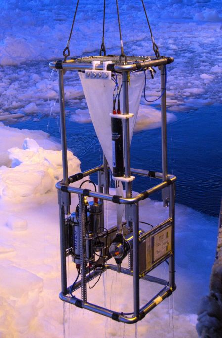
Contents

1.    Überblick und Fahrtverlauf                                            2

      Summary and Itinerary                                                 3

2.    Flow of Atlantic Water in Fram Strait and on the East Greenland
      Shelf                                                                 4

3.    HAUSGARTEN: Impact of Climate Change on Arctic Marine
      Ecosystems                                                            12

4.    Plankton Ecology and Biogeochemistry in the Changing Arctic
      Ocean (PEBCAO, FRAM Microbial observatory)                            17

5.    Temporal Variability of Nutrient and Carbon Transports into and out
      of the Arctic Ocean                                                   21

6.    Pathways and Missions of Climate-relevant Trace Gases in a
      Changing Arctic Ocean - PETRA                                         22

7.    Investigation of Emerging Organic Contaminants in the North
      Atlantic and the Arctic                                               24

8.    Trial Run of a New Helicopter Borne Scatterometer for Ice and Snow
      Remote Sensing                                                        26

9.    Teilnehmende Institute / Participating Institutions                   27

10.   Fahrtteilnehmer / Cruise Participants                                 29

11.   Schiffsbesatzung / Ship's Crew                                        31

                                              1
PS114 Expedition Programme

1.      ÜBERBLICK UND FAHRTVERLAUF
        Wilken-Jon von Appen
        Alfred-Wegner-Institut, Helmholtz Zentrum für Polar- und Meeresforschung
Nach dem Auslaufen aus Bremerhaven am 20. Juli wird Polarstern Reise PS114 mit einem
ca. 5 Tage langen Transit ins Arbeitsgebiet beginnen: die Fram-Straße zwischen Svalbard und
Grönland. Die Reise wird um eine große Anzahl an Verankerungsaufnahmen und
Verankerungsauslegungen, die mit der Helmholtz Infrastruktur Initiative FRAM in Verbindung
stehen, herum strukturiert sein. Die Reise wird von Ost nach West das Arbeitsgebiet abfahren,
um Verankerungen zu bedienen, die Teil sind von
(i)   Langzeitbeobachtungen der Temperatur und des Transports im West Spitzbergen
      Strom,
(ii) Langzeitbeobachtungen der der Stoffflüsse ins Sediment an der Meereiskante,
(iii) einer Prozessstudie, die die Primärproduktion in der euphotischen Zone an der Eiskante
      zum Ziel hat,
(iv) einer Prozessstudie um die saisonalen Eigenschaften der Rezirkulation in der Fram-
      Straße einzugrenzen und
(v) einer Prozessstudie um die saisonalen Strömungen von warmem Atlantikwasser auf
      dem Ostgrönlandschelf und unter den 79N Gletscher einzugrenzen.
An den meisten Tagen im Arbeitsgebiet werden zu den Tageszeiten der Mannschaft
Verankerungsaufnahmen oder Verankerungsauslegungen stattfinden. In den Nachtstunden
werden stationsbasierte Messungen u.a. mit der CTD-Rosette, dem Multinetz, dem LOKI, dem
kameragesteuerten Mehrkernsammler und dem Ozeanbodenbeobachtungssystem statt-
finden. Diese Instrumente messen verschiedene hydrographische und biologische Parameter
und sammeln Wasser-, Exemplar- und Sedimentproben für biologische und chemische
Analysen. Hydrographische und Strömungs-Eigenschaften werden auch mit Unterwegs-
systemen gemessen, und biologische und chemische Proben werden in regulären Zeitab-
ständen aus den Seewasser-Systemen von Polarstern genommen werden. Größen, die
untersucht werden sind, u.a.
(i)   Phytoplankton, Zooplankton und Bakterien Häufigkeit, Artenverteilung, und molekulare
      und genetische Variabilität,
(ii) Primärproduktion,
(iii) epibentische Megafauna,
(iv) gelöste und partikuläre inorganische und organische Nährstoffe und Kohlenstoff und
(v) Transportwege und Emissionen von Spurengasen N2O, CH4, DMS und CO.
Inkubationen werden die Transportraten der Spurengase unter sich ändernden Antriebs-
szenarien abschätzen. Während des Transits und in dem Arbeitsgebiet werden Luftproben
genommen werden für die Analyse von neuartigen organischen Schadstoffen. Im westlichen
Teil des Arbeitsgebiets, wo Meereis zu erwarten ist, werden Helikoptereinsätze Schneeproben
von Meereisschollen sammeln für die Analyse von neuartigen organischen Schadstoffen und
die Helikopter werden auch über Meereis fliegen, um ein neues Mikrowellerückstreumessgerät
für Eis und Schnee Fernerkundung zu testen. Nach einem kürzeren Transit wird die Reise in
Tromsø am 3. August enden.

                                               2
PS114 Expedition Programme

           Abb. 1.1: Vorläufiger Fahrtverlauf der PS114 von Bremerhaven nach Tromsø
             Fig. 1.1: Preliminary cruise track of PS114 from Bremerhaven to Tromsø

        SUMMARY AND ITINERARY
         Wilken-Jon von Appen
         Alfred Wegner Institute, Helmholtz Centre for Polar and Marine Research

After leaving Bremerhaven on July 10th, Polarstern cruise PS114 will start with a roughly 5-
day transit to the working area: Fram Strait between Svalbard and Greenland. The cruise will
be structured around a large number of mooring recoveries and deployments associated with
the Helmholtz Infrastructure Initiative FRAM. The cruise will progress from east to west across
the working area to service moorings that are part of
(i)    long-term observations of the West Spitsbergen Current temperature and transport,
(ii) long-term observations for sedimentary fluxes to the sea-floor,
(iii) a process study aiming at primary production in the euphotic zone at the ice-edge,
(iv) a process study to constrain the seasonal properties of the recirculation in Fram Strait,
       and

                                                3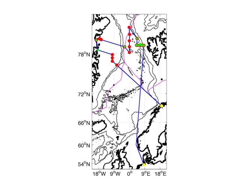
PS114 Expedition Programme

(v)   a process study to constrain the seasonal flow patterns of warm Atlantic Water on the
      East Greenland shelf and underneath the 79 North Glacier.
On most days in the working area, mooring recoveries or deployments will take place during
day time ship working hours. During night hours station-based sampling will take place
including the deployment of the CTD rosette, multinet, LOKI, TV multi-corer, and ocean floor
observation system. These instruments will measure various hydrographic and biological
parameters and retrieve water, specimen, and sediment samples for biological and chemical
analyses. Hydrographic and current properties will also be monitored with underway systems
and biological and chemical samples will be taken at regular intervals from sea-water intakes
of Polarstern. Properties to be investigated include
(i)   phytoplankton, zooplankton, and bacteria abundance, species distribution, and
      molecular and genetic variability,
(ii) primary production,
(iii) epibenthic megafauna,
(iv) dissolved and particulate inorganic and organic nutrients and carbon, and
(v) pathways and emissions of trace gases N2O, CH4, DMS, and CO.
Incubations will assess rates of trace gas exchanges under varying forcing. During the transit
and in the working area, air samples will be collected for analyses of emerging organic
contaminants. In the western part of the working area, where sea-ice is expected, helicopter
operations will retrieve snow samples from sea-ice floes for analyses of emerging organic
contaminants and the helicopters will fly over sea-ice to test a new scatterometer for ice and
snow remote sensing. After a shorter transit, the cruise will end in Tromsø on August 3rd.

2.       FLOW OF ATLANTIC WATER IN FRAM STRAIT AND ON
         THE EAST GREENLAND SHELF
         W.-J. von Appen (AWI), J. Schaffer (AWI), M. Monsees (AWI), D. Kulmey (AWI),
         J. Vernaleken (AWI), A. Behrendt (AWI), Z. Hofmann (AWI), M. Specht (AWI), C. Schmidt
         (AWI), M. Richter (AWI)
Objectives and scientific programme
West Spitsbergen Current
This cruise supports a long-term effort to monitor and quantify the variability of oceanic fluxes
through the Fram Strait with a particular emphasis on the physical oceanography.
The Arctic Ocean is a semi-enclosed marginal sea with the Bering Strait, the Canadian Arctic
Archipelago, and the Barents Sea being three shallow connections to the world oceans. The
Fram Strait is the only deep strait (2,700 m), thereby allowing for the exchange of intermediate
and deep waters between the Arctic Ocean and the Nordic Seas, which are in turn a marginal
sea of the North Atlantic. Atlantic origin water is cooled throughout the cyclonic boundary
current circulation in the Nordic Seas and enters the Arctic through the Barents Sea and the
eastern Fram Strait. The temperature and other properties of the inflowing warm and salty
Atlantic Water change in response to interannual variability (Beszczynska-Möller et al, 2012),
to large scale-, multi-year climate patterns, such as the North Atlantic Oscillation, and to global
climate change. The sum of these effects can be measured in the Fram Strait before it enters

                                                4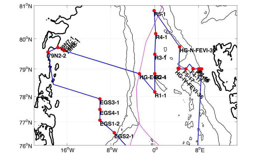
PS114 Expedition Programme

the Arctic Ocean, where it participates in the formation of the halocline north of Svalbard and
forms a mid-depth cyclonic boundary current. Cooling, freezing, sea-ice melt, mixing with
Pacific origin water, and the addition of large amounts of river runoff in the Arctic modifies the
inflowing water (Rudels et al, 2005) before it exits through the western Fram Strait (de Steur
et al, 2014). Thus observations of the outflow from the Arctic make it possible to monitor the
effects of many processes in the Arctic Ocean.
The complicated topography in the Fram Strait leads to a horizontal splitting of the inflowing
branches of Atlantic Water. Additionally, some of the Atlantic Water participates in a westward
flow called the recirculation that then turns southward to exit the Fram Strait back to the Nordic
Seas. The southward flowing cold and very fresh East Greenland Current is responsible for a
large part of the liquid freshwater export from the Arctic and most of the solid freshwater export
in the form of sea-ice. This freshwater has the potential to impact convection in the Nordic
Seas and the northern North Atlantic and in turn the meridional overturning circulation.
Since 1997, AWI and the Norwegian Polar Institute have maintained a mooring array across
the Fram Strait to monitor the fluxes of volume flux, and the temperature and salinity of the
flow into and out of the Arctic Ocean through this gateway.

Atlantic Water Recirculation
The recirculation of Atlantic Water (AW) in Fram Strait controls how much of the warm nutrient
rich AW flowing northward in the West Spitsbergen Current enters the Arctic Ocean. This
determines the oceanic heat input and therefore the extent of the partially ice-free halocline
formation area north of Svalbard (Rudels et al, 2005). The inflow also impacts the light and
nutrient distribution in the Arctic and therefore habitat distribution and biogeography in the
Arctic Ocean (Metfies et al, 2016) as well as their future evolution.
The part of the AW that does not enter the Arctic Ocean follows distinct, but poorly understood,
pathways in Fram Strait and is then exported southward in the East Greenland Current. Special
to Fram Strait is also that the southward advection of sea-ice and the northward advection of
AW balance such that the ice-edge location varies very little. Hence, the region where frontal
dynamics associated with the meltwater front at the interface between the two can affect the
physics (e.g. von Appen et al, 2018) and biology (e.g. Wulff et al, 2016) is confined to a
relatively small area. The Polar Water outflow is also located vertically above the AW. While it
remains to be explained how that happens, it is clear that the large stratification associated
with that transition leads to a similar situation to the halocline of the Arctic Ocean where the
vertical nutrient supply to the shallow euphotic zone is inhibited and the primary production
has to adapt accordingly. The meridional extent over which the recirculation takes place has
not been constrained. A recent numerical model study (Hattermann et al, 2016) has suggested
that there are in fact two branches of the recirculation. A southern branch is thought to be
comparatively steady, while a northern branch essentially can be considered as an extended
region in which eddies are propagating westwards. The recirculation also likely has a baroclinic
geostrophic and a barotropic wind-driven component, but it has only been possible to show
that both contribute to the recirculation between 78°50'N and 79°0'N (de Steur et al, 2014). It
is also known that the West Spitsbergen Current is unstable at 78°50'N, especially in winter
(von Appen et al, 2016), but it is not known whether there is even more eddy generation further
north. The large seasonality in the region (e.g. de Steur et al, 2014, von Appen et al, 2016)
also mean that an understanding solely based on the summer time situation (calmest season)
will inherently be incomplete. The dynamics that lead to the splitting of the AW inflow are
essential to other regions of the ocean as well. For example, the Irminger Current splits at
Denmark Strait and only some of the warm water flows northward through that strait. The
lacking dynamical understanding of the present day recirculation also currently makes it

                                                5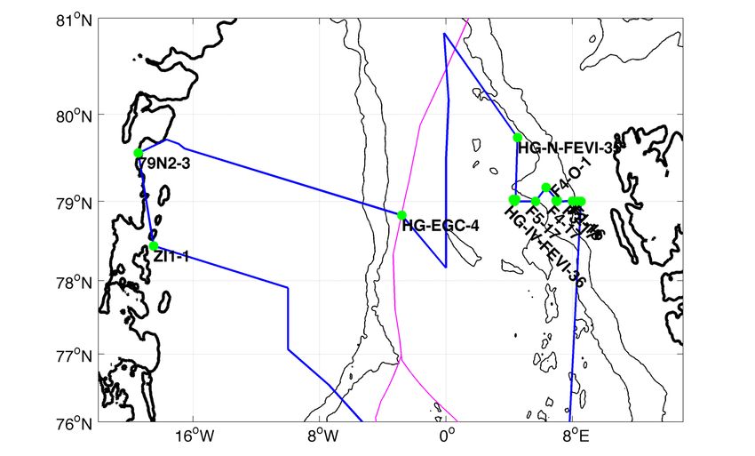
PS114 Expedition Programme

impossible to predict how the recirculation and the processes influenced by it will evolve in the
future under changing forcing conditions associated with e.g. climate change.
In order to improve the understanding of the recirculation in Fram Strait, it is crucial to measure
several physical and biological parameters over the presumed meridional extension of the
recirculation including during the winter months. The temperature and salinity distribution in
space and time can be used to track the water of the recirculation and determine its
modification and vertical motion reflected in the depth of the temperature maximum. The
meridional gradient of the density can be used to elucidate the location of baroclinic
geostrophic flows and combination with direct velocity measurements can reveal the full
current structure. The short term variability of the currents gives information on the eddy field
and its possible contribution to the flow. Vertical velocity shear can highlight the interface
between the lighter Polar outflow water and the AW. The horizontal motion of those two layers
is likely quite different in some regions and possibly also decoupled from the overlying ice
motion. The vertical migration of the interface between the two water masses in response to
external factors can be tracked even in the absence of profiling temperature and salinity
measurements. The oxygen distribution provides insights on the primary productivity while
acoustic backscatter elucidates the presence and migration of zooplankton which possibly
responds to changes in the physical environment.
The ideal location to measure these properties is along the prime meridian (0°EW). This is
outside of the West Spitsbergen Current and the East Greenland Current and what happens
there is therefore not due to the boundary currents, but rather due to the recirculation. The
prime meridian also avoids the 5,500 m deep Molloy Hole whose likely topographic steering
would add an additional level of complexity to this already complex question. The prime
meridian also cuts across the ice-edge (near 79°N at 0°EW) such that the influence of the
recirculation on the ice-edge can be studied there. Additionally, the small amount of data that
exist on the meridional structure of the recirculation is located along the prime meridian
(Marnela et al 2013) and it is hence valuable to collect new data at a comparable location.
Mooring data will also be used for validation of and assimilation into a numerical model of the
region around the Fram Strait.
For these reasons, in 2016 during PS100 five equally spaced moorings were deployed at the
following locations along the prime meridian (0°EW): 78°10'N, 78°50'N, 79°30'N, 80°10'N, and
80°50'N which is in water depths between 2,000 m and 3,000 m. Velocity as well as
temperature, salinity, and oxygen are being measured in the upper 750 m on the moorings.

East Greenland Shelf Circulation
Mass loss from the Greenland Ice Sheet presently accounts for a third to a quarter of sea- level
rise (Milne et al 2009) and the rate of mass loss is increasing (Velicogna 2009). The dominant
mechanism is increased mass discharge along the marine margins where numerous major
outlet glaciers have undergone a nearly simultaneous retreat, acceleration and thinning
(Rignot and Kanagaratnam 2006; Howat et al 2008; Stearns and Hamilton 2007; Dietrich et al
2007). Both data and models indicate that this acceleration was triggered by a change at the
tidewater margins of these glaciers (Thomas 2004; Nick et al 2009; Pritchard et al 2009),
suggesting that the ocean plays a key role in modulating the ice sheet's mass balance (Vieli
and Nick 2011; Straneo et al 2012).
The proposed oceanic trigger is supported by recent studies showing that warm Atlantic waters
are present and circulating in Greenland's glacial fjords (Holland et al 2008; Straneo et al 2010;
Murray et al 2010; Straneo et al 2011) and by the observation that these waters were warming
and accumulating in the subpolar North Atlantic at the same time as the glaciers started to
retreat (e.g. Bersch et al 2007).

                                                6
PS114 Expedition Programme
Greenland's glacier acceleration has been concentrated along the southeastern and western
margins terminating in the subpolar North Atlantic. Only recently, Helm et al (2014) observed
a general reduction in ice sheet elevation near the margins in the northeast of Greenland.
Here, mainly two glaciers Nioghalvfjerdsfjorden glacier and Zachariae Isstrom drain the
Northeast Greenland Ice Stream (NEGIS) whose drainage basin contains more than 15 % of
the Greenland Ice Sheet area (Rignot and Kanagaratnam 2006). Zachariae Isstrom lost about
5 Gt/yr of its mass since 2003 and was observed to retreat at an accelerated rate since fall
2012, whereas no mass loss but an increased bottom melting was found at
Nioghalvfjerdsfjorden glacier (Mouginot et al 2015). Khan et al (2014) observed an acceleration
of the ice flow of Nioghalvfjerdsfjorden glacier and a sustained dynamic thinning of NEGIS
which they linked to a regional warming. The fact that a warming and thickening of the Atlantic
layer has recently been observed in the Nordic Seas (e.g. in Fram Strait; Beszczynska-Möller
et al 2012) raises the question of whether the ocean changes may have triggered the fast
retreat of Zachariae Isstrom (as suggested by Mouginot et al 2015) and will trigger unstable
behaviour of Nioghalvfjerdsfjorden glacier.
Warm Atlantic water is carried to the North by the North Atlantic Current - Norwegian Atlantic
Current - West Spitsbergen Current system. In Fram Strait a sizable fraction of the Atlantic
water recirculates to the south on the East Greenland continental slope. Studies on the eastern
Greenland shelf in the 1980s and 1990s found this recirculating Atlantic water (RAW) to
penetrate through sea bed troughs onto the East Greenland shelf (e.g. Bourke et al 1987)
below the fresh and cold polar waters (PW).
The Atlantic water mass found on the shelf was described by Bourke et al (1987) as Atlantic
Intermediate Water (AIW) with temperatures ranging between 0°C and 3°C and salinities
between 34.5 and 34.9. Budeus et al (1997) found two distinct types of Atlantic waters in the
trough system. They found 1°C warm Atlantic waters with salinities of 34.9 to be present
throughout the southern Norske Trough, which cooled and freshened towards 79N glacier, and
0.5°C warm Atlantic waters with salinities of 34.8 in the northern Westwind Trough. An
anticyclonic surface circulation on the continental shelf following the trough axis was found
based on hydrographic observations (Bourke et al 1987, Schneider and Budeus 1995), moored
(Topp and Johnson 1997) and ship based (Johnson and Niebauer 1995) velocity
measurements. In addition, Topp and Johnson (1997) proposed an anticyclonic subsurface
circulation from moored measurements in Westwind Trough, in contrast to Budeus et al.
(1997), who proposed that there is no one-directional flushing of the trough system. In the
trough area east of the outlet glaciers, i.e. between Westwind and Norske Trough, Budeus and
Schneider (1995) suggested a sill depth of 250 m causing the differences in water properties.
This part of the shelf has rarely been studied due to a perennially fast sea ice cover (e.g.
Schneider and Budeus 1995; Schneider and Budeus 1997), but is of strong interest when
studying warm water pathways towards the outlet glaciers. Between 1979-1999 and 2000-
2016, the temperature in the deep part of Norske Trough increased by more than 0.5°C
(Schaffer et al, 2017).
A survey of Nioghalvfjerdsfjorden glacier in the mid-1990s led to very high estimates of
submarine melt rates (about 40 m/yr locally, with a mean basal melt rate of 8 m/yr), which
account for the bulk of the ice shelf mass loss (Mayer et al 2000). The melting was attributed
to the presence of AIW in the 600 m to 800 m deep subglacial cavity as observed in several
conductivity, temperature and depth (CTD) profiles collected at the glacier's margins (Thomsen
et al 1997; Mayer et al 2000). A more recent survey conducted in the summer of 2009 (Straneo
et al 2012) confirmed that the AIW found under the floating ice tongue still contains large
amounts of heat to drive melting. Based on three CTD sections taken north of the main glacier
front, Wilson and Straneo (2015) discussed that warm AIW cannot enter the cavity through
Dijmphna Sund due to a sill of 170 m depth but needs to pass the eastern pinned glacier front.
7PS114 Expedition Programme
They proposed that the exchange of warm Atlantic waters between the continental shelf and
the cavity through Norske Trough occurs on timescales of less than a year. Fast hydraulically
controlled flow into the cavity was recently observed to supply warm AIW to the overturning
circulation in the cavity (Schaffer 2017).
Nonetheless these implications are not based on sufficient observations towards the
east/southeast of Nioghalvfjerdsfjorden glacier, and aspects of a direct pathway of warm AIW
from the shelf break, through Norske Trough towards Nioghalvfjerdsfjorden glacier are still
missing.
Work at sea
Moorings had been deployed in the Fram Strait and on the East Greenland shelf by the Alfred
Wegener Institute in 2016 (PS100), and 2017 (PS107, PS109). It is planned that the 24
moorings currently still in the water (Fig. 2.1, Table 2.1) shall be recovered during PS114.
Another large part of the work will be to deploy 15 moorings (Fig. 2.2, Table 2.1).
Conductivity-Temperature-Depth (CTD) measurements will be carried out with the ship-board
SBE 9/11+ CTD system, which is combined with a SBE 32 Carousel Water Sampler (Seabird).
In addition, current measurements of the upper ~200 m along the cruise track will be collected
with the vessel mounted ADCP.
Fig. 2.1: Positions of the moorings to be recovered in Fram Strait and on the East Greenland shelf
8PS114 Expedition Programme
Fig. 2.2: Positions of the moorings to be deployed in Fram Strait and on the East Greenland shelf
Tab. 2.1: Mooring recoveries and deployments planned for PS114
Name Longitude Latitude Deployment time Depth Top Deployment
Degrees
Degrees
station
Minutes
Minutes
Meters
Meters
Minute
Month
Hour
Year
Day
Recoveries
HG-IV-FEVI-36 4 20.02 E 79 0.00 N 2017 8 11 6 4 2609 52 PS107/038-1
HG-IV-S-2 4 15.71 E 79 1.36 N 2017 8 11 8 14 2599 20 PS107/038-2
HG-IV-SWIPS-2017 4 24.31 E 79 1.39 N 2017 8 11 12 12 2535 138 PS107/038-4
F4-S-2 6 57.86 E 79 0.70 N 2017 8 15 10 16 1260 18 PS107/049-1
HG-N-FEVI-35 4 31.44 E 79 44.49 N 2017 8 9 16 37 2692 48 PS107/035-1
HG-EGC-4 2 47.53 W 78 49.86 N 2017 8 4 13 3 2589 55 PS107/025-2
F1-16 8 32.51 E 79 0.01 N 2016 7 24 9 0 345.9 238 PS100/0023-1
F2-18 8 19.84 E 79 0.02 N 2016 7 23 6 57 785.2 43 PS100/0016-1
F3-17 7 59.84 E 79 0.12 N 2016 7 23 8 44 1075 44 PS100/0017-1
F4-17 7 0.03 E 79 0.01 N 2016 7 23 13 44 1219 47 PS100/0018-1
F5-17 5 40.12 E 79 0.02 N 2016 7 23 17 53 2100 64 PS100/0019-1
R1-1 0 0.04 E 78 10.21 N 2016 8 9 13 54 3013 64 PS100/0106-1
R2-1 0 0.09 E 78 50.01 N 2016 7 27 13 48 2597 48 PS100/0039-2
R3-1 0 0.03 W 79 30 N 2016 7 28 23 25 2778 63 PS100/0045-1
R4-1 0 10.19 E 80 9.75 N 2016 7 29 18 14 3034 60 PS100/0047-1
R5-1 0 7.23 W 80 51.18 N 2016 7 31 12 34 3140 76 PS100/0053-1
79N6-1 16 53.36 W 79 40.15 N 2016 8 27 14 59 256.6 249 PS100/0263-3
79N7-1 17 40.4 W 79 43.23 N 2016 8 28 8 38 404.1 394 PS100/0272-1
79N8-1 16 32.61 W 79 37.15 N 2016 8 28 11 41 287 186 PS100/0273-1
79N2-2 19 27.83 W 79 34.01 N 2017 9 23 15 20 476 83 PS109/071-1
EGS4-1 10 0.15 W 77 29.98 N 2017 10 3 19 25 262 103 PS109/133-1
EGS3-1 9 59.79 W 77 54.40 N 2017 10 3 16 27 233 98 PS109/132-2
EGS2-1 7 22.58 W 76 32.76 N 2017 10 6 11 8 763 81 PS109/148-1
EGS1-2 10 0.10 W 77 3.97 N 2017 10 4 14 34 425 92 PS109/138-2
Deployments
HG-IV-FEVI-36 4 20.02 E 79 0.00 N 2018 2609 52
HG-IV-S-2 4 15.71 E 79 1.36 N 2018 2599 20
HG-IV-SWIPS-2017 4 24.31 E 79 1.39 N 2018 2535 138
F4-S-2 6 57.86 E 79 0.70 N 2018 1260 18
F4-W-1 7 2.50 E 79 0.70 N 2018 1260 150
F4-O-1 6 20.00 E 79 10.00 N 2018 1260 95
HG-N-FEVI-35 4 31.44 E 79 44.49 N 2018 2692 48
HG-EGC-4 2 47.53 W 78 49.86 N 2018 2589 55
F1-16 8 32.51 E 79 0.01 N 2018 345.9 238
F2-18 8 19.84 E 79 0.02 N 2018 785.2 43
F3-17 7 59.84 E 79 0.12 N 2018 1075 44
F4-17 7 0.03 E 79 0.01 N 2018 1219 47
F5-17 5 40.12 E 79 0.02 N 2018 2100 64
79N2-3 19 27.83 W 79 34.01 N 2018 476 83
9PS114 Expedition Programme
Expected results
The planned mooring recoveries will prolong the time series of Atlantic Water temperature and
velocity in the West Spitsbergen Current. It is expected that the deployment years 2016-2018
will elucidate some of the impacts of the Arctic air temperature warming events. The moorings
along 0°EW will allow for the first ever assessment of the dynamics of the Atlantic Water
recirculation in winter. Furthermore, it is expected that the moorings to be recovered on the
East Greenland shelf will provide insights how Atlantic Water gets underneath 79NG. The CTD
measurements will improve the understanding of the interaction of Atlantic Water and Polar
Water and how they flow into the Arctic Ocean, towards the Nordic Seas overflows and towards
Greenland’s glaciers.
Data management
The data recorded by the moored instruments that will be recovered on PS1114 will be
processed after the cruise at AWI and submitted to the PANGAEA data publisher. Some of the
moorings that will be deployed on PS1114 will be recovered in 2019 and the rest will be
recovered in 2020. The data recorded on those instruments will accordingly be processed after
recovery and submitted to the PANGAEA data publisher at that time. Likewise, the data
collected during PS1114 from the CTD will be processed at AWI and afterwards submitted to
the PANGAEA data publisher.
References
Bersch, M., I. Yashayaev, and K. P. Koltermann (2007), Recent changes of the ther- mohaline circulation
in the subpolar north atlantic, Ocean Dynamics, 57(3), 223–235, doi:10.1007/s10236-007-0104-7.
Beszczynska-Möller, A., E. Fahrbach, U. Schauer, and E. Hansen (2012), Variability in atlantic water
temperature and transport at the entrance to the arctic ocean, 1997-2010, ICES Journal of Marine
Science: Journal du Conseil, 69(5), 852–863, doi: 10.1093/icesjms/fss056.
Bourke, R. H., J. L. Newton, R. G. Paquette, and M. D. Tunnicliffe (1987), Circulation and water masses
of the east greenland shelf, Journal of Geophysical Research: Oceans, 92(C7), 6729–6740,
doi:10.1029/JC092iC07p06729.
Budeus, G., and W. Schneider (1995), On the hydrography of the northeast water polynya, Journal of
Geophysical Research: Oceans, 100 (C3), 4287–4299, doi:10.1029/94JC02024. Budeus, G., W.
Schneider, and G. Kattner (1997), Distribution and exchange of water masses in the northeast water
polynya (greenland sea), Journal of Marine Systems, 10(14), 123 – 138,
doi:http://dx.doi.org/10.1016/S0924-7963(96)00074-7.
de Steur, L., E. Hansen, R. Gerdes, M. Karcher, E. Fahrbach, and J. Holfort (2009), Freshwater fluxes
in the East Greenland Current: A decade of observations, Geophysical Research Letters, 36(23).
de Steur, L., E. Hansen, C. Mauritzen, A. Beszczynska-Möller, and E. Fahrbach (2014), Impact of
recirculation on the East Greenland Current in Fram Strait: Results from moored current meter
measurements between 1997 and 2009, Deep Sea Research, 92, 26–40.
Dietrich, R., H.-G. Maas, M. Baessler, A. Ru ̈lke, A. Richter, E. Schwalbe, and P. West- feld (2007),
Jakobshavn isbræ, west greenland: Flow velocities and tidal interaction of the front area from 2004
field observations, J. Geophys. Res., 112(F03S21), doi: 10.1029/2006JF000601.
Hattermann, T., P. E. Isachsen, W.-J. von Appen, J. Albretsen, and A. Sundfjord (2016), Where eddies
drive recirculation of Atlantic Water in Fram Strait, Geophysical Research Letters, 43, 1-9.
Helm, V., A. Humbert, and H. Miller (2014), Elevation and elevation change of greenland and antarctica
derived from cryosat-2, The Cryosphere, 8 (4), 1539–1559, doi:10.5194/tc- 8-1539-2014.
Holland, D. M., R. H. Thomas, B. de Young, M. H. Ribergaard, and B. Lyberth (2008), Acceleration of
jakobshavn isbrae triggered by warm subsurface ocean waters, Nature Geosci, 1(10), 659–664.
Hopkins, T. S. (1991), The GIN seas synthesis of its physical oceanography and literature review
19721985, Earth-Science Reviews, 30(34), 175 – 318, doi: http://dx.doi.org/10.1016/0012-
8252(91)90001-V.
10PS114 Expedition Programme
Howat, I. M., I. Joughin, M. Fahnestock, B. E. Smith, and T. A. Scambos (2008), Synchronous retreat
and acceleration of southeast Greenland outlet glaciers 2000- 06: ice dynamics and coupling to
climate, Journal of Glaciology, 54, 646–660, doi: 10.3189/002214308786570908.
Johnson, M., and H. J. Niebauer (1995), The 1992 summer circulation in the northeast water polynya
from acoustic doppler current profiler measurements, Journal of Geo- physical Research: Oceans,
100(C3), 4301–4307, doi:10.1029/94JC01981.
Khan, S. A., K. H. Kjær, M. Bevis, J. L. Bamber, J. Wahr, K. K. Kjeldsen, A. A. Bjørk, N. J. Korsgaard,
L. A. Stearns, M. R. van den Broeke, L. Liu, N. K. Larsen, and I. S. Muresan (2014), Sustained mass
loss of the northeast greenland ice sheet triggered by regional warming, Nature Clim. Change, 4 (4),
292–299.
Mayer, C., N. Reeh, F. Jung-Rothenhusler, P. Huybrechts, and H. Oerter (2000), The sub- glacial cavity
and implied dynamics under nioghalvfjerdsfjorden glacier, ne-greenland, Geophysical Research
Letters, 27(15), 2289–2292, doi:10.1029/2000GL011514.
Metfies, K., W.-J. von Appen, E. Kilias, A. Nicolaus, and E.-M. N ̈othig (2016), Biogeography and
Photosynthetic Biomass of Arctic Marine Pico-Eukaroytes during Summer of the Record Sea Ice
Minimum 2012, PLOS ONE, 11(2), doi: doi:10.1371/journal.pone.0148512.
Milne, G. A., W. R. Gehrels, C. W. Hughes, and M. E. Tamisiea (2009), Identifying the causes of sea-
level change, Nature Geosci, 2 (7), 471–478.
Mouginot, J., E. Rignot, B. Scheuchl, I. Fenty, A. Khazendar, M. Morlighem, A. Buzzi, and J. Paden
(2015), Fast retreat of zachariæ isstrøm, northeast greenland, Science,
doi:10.1126/science.aac7111.
Murray, T., K. Scharrer, T. D. James, S. R. Dye, E. Hanna, A. D. Booth, N. Selmes, A. Luckman, A. L.
C. Hughes, S. Cook, and P. Huybrechts (2010), Ocean regulation hypothesis for glacier dynamics in
southeast greenland and implications for ice sheet mass changes, Journal of Geophysical Research:
Earth Surface, 115 (F3), doi: 10.1029/2009JF001522, f03026.
Nick, F. M., A. Vieli, I. M. Howat, and I. Joughin (2009), Large-scale changes in greenland outlet glacier
dynamics triggered at the terminus, Nature Geosci, 2 (2), 110–114.
Pritchard, H. D., R. J. Arthern, D. G. Vaughan, and L. A. Edwards (2009), Extensive dynamic thinning
on the margins of the greenland and antarctic ice sheets, Nature, 461(7266), 971–975.
Rignot, E., and P. Kanagaratnam (2006), Changes in the velocity structure of the green- land ice sheet,
Science, 311 (5763), 986–990, doi:10.1126/science.1121381.
Rudels, B., G. Bjo ̈rk, J. Nilsson, P. Winsor, I. Lake, and C. Nohr (2005), The interaction between waters
from the Arctic Ocean and the Nordic Seas north of Fram Strait and along the East Greenland
Current: results from the Arctic Ocean-02 Oden expedition, Journal of Marine Systems, 55(1), 1–30.
Schaffer, J., W.-J. von Appen, P. A. Dodd, C. Hofstede, C. Mayer, L. de Steur, and T. Kanzow (2017),
Warm water pathways toward Nioghalvfjerdsfjorden Glacier, Northeast Greenland, J. Geophys. Res.
Oceans, 122, doi:10.1002/ 2016JC012462.
Schaffer, J. (2017), Ocean impact on the 79 North Glacier, Northeast Greenland, PhD thesis, University
of Bremen, http://nbn-resolving.de/urn:nbn:de:gbv:46-00106281-12
Schneider, W., and G. Budeus (1997), A note on norske ø ice barrier (northeast green- land), viewed
by landsat 5, Journal of Marine Systems, 10(14), 99 – 106, doi: http://dx.doi.org/10.1016/S0924-
7963(96)00076-0.
Schneider, W., and G. Budeus (1995), On the generation of the northeast water polynya, Journal of
Geophysical Research: Oceans, 100 (C3), 4269–4286, doi:10.1029/94JC02349. Stearns, L. A., and
G. S. Hamilton (2007), Rapid volume loss from two east greenland outlet glaciers quantified using
repeat stereo satellite imagery, Geophysical Research Letters, 34(5), doi:10.1029/2006GL028982,
l05503.
Straneo, F., G. S. Hamilton, D. A. Sutherland, L. A. Stearns, F. Davidson, M. O. Hammill, G. B. Stenson,
and A. Rosing-Asvid (2010), Rapid circulation of warm subtropical waters in a major glacial fjord in
east greenland, Nature Geosci, 3(3), 182–186.
Straneo, F., R. G. Curry, D. A. Sutherland, G. S. Hamilton, C. Cenedese, K. Vage, and L. A. Stearns
(2011), Impact of fjord dynamics and glacial runoff on the circulation near helheim glacier, Nature
11PS114 Expedition Programme
Geosci, 4 (5), 322–327. Straneo, F., D. A. Sutherland, D. Holland, C. Gladish, G. S. Hamilton, H. L.
Johnson, E. Rignot, Y. Xu, and M. Koppes (2012-11-01T00:00:00), Characteristics of ocean waters
reaching greenland’s glaciers, Annals of Glaciology, 53(60), 202–210, doi:
doi:10.3189/2012AoG60A059.
Thomas, H. R. (2004), Force-perturbation analysis of recent thinning and accel- eration of Jakobshavn
Isbrae, Greenland, Journal of Glaciology, 50, 57–66, doi: 10.3189/172756504781830321.
Thomsen, H. H., N. Reeh, O. B. Olesen, C. E. Bøggild, W. Starzer, A. Weidick, and A. K. Higgins (1997),
The nioghalvfjerdsfjorden glacier project, north-east greenland: a study of ice sheet response to
climatic change, Geology of Greenland Survey Bulletin, 176, 95–103.
Topp, R., and M. Johnson (1997), Winter intensification and water mass evolution from yearlong current
meters in the northeast water polynya, Journal of Marine Systems, 10(14), 157 – 173,
doi:http://dx.doi.org/10.1016/S0924-7963(96)00083-8.
Velicogna, I. (2009), Increasing rates of ice mass loss from the greenland and antarctic ice sheets
revealed by grace, Geophysical Research Letters, 36(19), doi: 10.1029/2009GL040222, l19503.
Vieli, A., and F. M. Nick (2011), Understanding and modelling rapid dynamic changes of tidewater outlet
glaciers: Issues and implications, Surveys in Geophysics, 32(4), 437– 458, doi:10.1007/s10712-011-
9132-4.
von Appen, W.-J., U. Schauer, T. Hattermann, and A. Beszczynska-Möller (2016), Seasonal cycle of
mesoscale instability of the West Spitsbergen Current, Journal of Physical Oceanography, 46 (4),
1231-1254, doi:10.1175/JPO-D-15-0184.1.
von Appen, W.-J., C. Wekerle, L. Hehemann, V. Schourup-Kristensen, C. Konrad, and M. Iversen, 2018:
Observations of a submesoscale cyclonic filament in the marginal ice zone, Geophysical Research
Letters, in press, doi:10.1029/2018GL077897
Wilson, N. J., and F. Straneo (2015), Water exchange between the continental shelf and the cavity
beneath nioghalvfjerdsbr (79 north glacier), Geophysical Research Letters, 42(18), 7648–7654,
doi:10.1002/2015GL064944, 2015GL064944.
Wullf, T., E. Bauerfeind, and W.-J. von Appen (2016), Physical and ecological processes at a moving
ice edge in the Fram Strait as observed with an AUV, Deep Sea Research, 115, 253-264.
3. HAUSGARTEN: IMPACT OF CLIMATE CHANGE ON
ARCTIC MARINE ECOSYSTEMS
N. Lochthofen (AWI), J. Bäger (AWI), F. Eckhard (AWI), L. Frommhold (AWI),
F. Krauß (AWI), J. Ludszuweit (AWI), B. Sablotny (AWI), M. Seifert (AWI), R. Stiens
(AWI), C. Konrad (AWI), W.-J. von Appen (AWI), M. Iversen (AWI, not on board), T.
Soltwedel (AWI, not on board)
Objectives and scientific programme
While always fluctuating, the global climate is presently experiencing a period of rapid change,
with a warming trend amplified in the Arctic region. Results of large-scale simulations of the
future Earth’s climate by several global climate models predict a further increase in
temperatures, also leading to further reduction in ice cover. Moreover, there has been a
significant thinning of the sea ice by approx. 50 % since the late 1950s.
The shift from a white cold ocean to a darker, warmer ocean will have severe impacts on the
polar marine ecosystem. Thinner ice may permit better growth of ice algae, but more rapid
spring melting may reduce their growing season. The timing and location of pelagic primary
production will generally alter. Whether sea ice retreat generally leads to an increase in primary
12PS114 Expedition Programme
productivity is under debate, but biogeochemical models predict no or even negative changes
in productivity and export flux. Altered algal abundance and composition will affect the
zooplankton community structure and subsequently the flux of particulate organic matter to the
seafloor, where the quantity and quality of this matter will impact benthic communities.
Changes in the predominance of certain trophic pathways will have cascading effects
propagating through the entire marine community. Generally, arctic marine organisms will be
compromised by temperature regimes approaching the limits of their thermal capacity. As a
consequence, warmer waters in the Arctic will allow a northward expansion of sub-arctic and
boreal species. Besides an increasing water temperature, expanding ocean acidification will
pose another threat to pelagic and benthic life in the Arctic Ocean.
To detect and track the impact of large-scale environmental changes in the transition zone
between the northern North Atlantic and the central Arctic Ocean, and to determine
experimentally the factors controlling deep-sea biodiversity, the Alfred-Wegener-Institute
Helmholtz-Zentrum für Polar- und Meeresforschung (AWI) established the LTER (Long-Term
Ecological Research) observatory HAUSGARTEN. Regular sampling as well as the
deployment of moorings and different free-falling systems (bottom-lander), which act as local
observation platforms, has taken place since the observatory was established back in 1999.
Since 2014, this observatory is successively extended within the frame of the HGF financed
infrastructure project FRAM (Frontiers in Arctic marine Monitoring) and currently covers 21
permanent sampling sites on the West-Spitsbergen and East-Greenland slope at water depths
between 250 and 5,500 m.
Ongoing climate change will impact marine ecosystems in a variety of ways, and polar
environments are believed to be particularly sensitive to these changes. Increasing
atmospheric CO2 concentration will lead to a reduction of ocean pH, which is expected to exert
a significant impact on marine calcifying organisms. Reductions in sea-ice cover and warming
of water masses will modify ocean stratification and restrict the supply of nutrients to the
euphotic zone. Taken together with anticipated changes in light conditions, net phytoplankton
growth is expected to change with important ramifications for Arctic ecosystem structure and
biogeochemical fluxes. In particular the quantity of photosynthetically produced organic matter
exported from the surface ocean is likely to change under these conditions.
These changes have clear implications for the sequestration of atmospheric CO2 and the
structure and function of benthic ecosystems that principally rely on this energy source from
the pelagic. Considering the importance of these processes, reliably detecting the effects of
climate change and understanding the influence of anthropogenic forcing on Arctic ecosystems
is a clear priority. As part of our efforts to observe and detect long-term changes in Arctic
Ocean ecosystems, we deployed a network of fixed- point moorings in the Fram Strait. On the
one hand these moorings reflect a continuation of the well-established and long-term efforts of
monitoring particle flux in the Fram Strait as part of the LTER Observatory HAUSGARTEN. In
addition to this, new mooring arrays were designed to sample biogeochemical and physical
properties in the upper water column to link with particle flux observations. These arrays
include autonomous water samplers and autonomous particle samplers that are capable of
collecting discrete samples with weekly resolution and preserving them for detailed analysis
upon recovery. This work is part of the Frontiers in Arctic marine Monitoring (FRAM)
infrastructure project.
To determine the transfer of organic matter from the upper productive layer in the water column
to the bottom of the ocean, measurements of settling particles are performed by means of
year-round moored sediment traps that provide information on the quantity and seasonality of
vertical particle flux. The moorings are also equipped with current meters (RCMs) and self-
recording CTDs, to gain information on the hydrographic conditions in the study area. Results
obtained by these instruments are of major importance for the interpretation of the results
13PS114 Expedition Programme
derived by the sediment traps, as the settling particles can be transported over long distances
before arriving at the seabed.
To determine the seasonal changes in nutrient concentrations in the euphotic zone, water
samplers were deployed in 2017 (PS107) at approximately 20 m and 80 m depth. In total, 24
discrete samples are being taken with weekly to monthly resolution (depending on season) to
follow the biological drawdown of nutrients. The moorings are also equipped with a physical
and biogeochemical sensor package including SBE37-SMP-ODO (temperature, salinity,
oxygen), SAMI pH, SAMI pCO2, Wetlabs PAR (photosynthetically active radiation), Wetlabs
Ecotriplet (Chlorophyll and CDOM fluorescence plus scattering), SUNA Deep Nitrate, current
meters, and Acoustic Doppler Current Profilers. The combination of these sensors and the
water samplers, in combination with the deployment of a profiling winch facilitates the
assessment of seasonal stratification and nutrient concentrations above and below the
pycnocline. The nutrient drawdown enables an estimate of new production. Furthermore, the
samples will be used for DNA sequencing to examine seasonal changes in bacterial
community structure. The particle samplers collect and preserve filters for DNA extraction and
sequencing that together with the fluorescence sensors allow us to track the progression of
phytoplankton biomass and community composition over different seasons. These efforts give
us a novel year-round description of biological, chemical, and physical processes in the Fram
Strait.
In addition, water samplers were deployed at ~80 m water depth in the anticipated cores of the
West Spitsbergen and East Greenland Currents. Together with detailed measurements of
physical parameters, these samples will be used to measure the nutrient composition of water
masses flowing into and out of the Arctic Ocean through the Fram Strait.
During Polarstern expedition PS114, multidisciplinary research activities will be conducted at
a sub-set of stations mainly in the northern and western HAUSGARTEN area (Fig. 3.1).
Fig. 3.1: Permanent sampling sites of the LTER Observatory HAUSGARTEN in Fram Strait;
red circles indicate stations to be visited during Polarstern expedition PS114
14PS114 Expedition Programme
Work at sea
Surface water characteristics and vertical flux of particulate organic matter
At the central HAUSGARTEN site HG-IV (see Fig. 3.1), we will recover and re-deploy a special
mooring with a prototype profiling winch system carrying a sensor package. This device has
been developed within the BMBF funded project ICOS-D (Integrated Carbon Observation
System, Germany) and shall conduct measurements within the upper 200 m of the water
column at regular preprogramed intervals. At present, the sensor package consists of
instruments for measuring carbon dioxide, oxygen, conductivity, temperature, pressure, and
chlorophyll fluorescence.
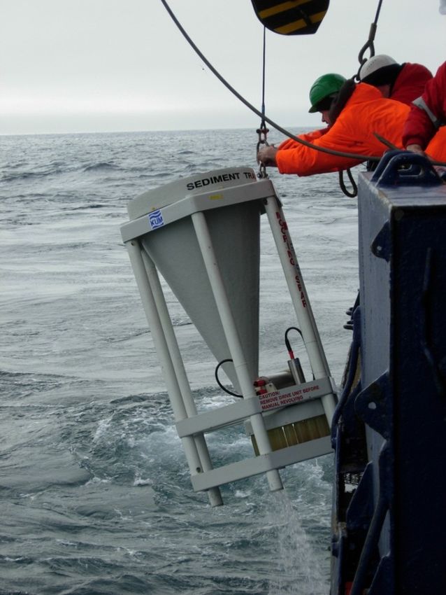
Measurements of the vertical flux of particulate matter at HAUSGARTEN have been conducted
since the establishment of the observatory. By means of these measurements we are able to
quantify the export of organic matter from the sea surface to the deep sea, and trace changes
in these fluxes over time. The organic material which is produced in the upper water layers or
introduced from land is the main food source for deep-sea organisms. Estimations of organic
matter fluxes are conducted by bottom-tethered moorings carrying sediment traps (Fig. 3.2) at
~200 m and ~1,000 m below sea-surface, and about 180 m above the seafloor. In addition,
HAUSGARTEN moorings carry autonomous McLane RAS 500 water samplers that are
programmed to collect and preserve water samples
(~0.5 L) with approximately weekly resolution, as well
as particle samplers that filter and preserve ~10 L water
samplers with approximately bi-weekly resolution.
Besides these instruments, the moorings are equipped
with Aanderaa currentmeters (RCM11, Seaguard) and
self-recording CTDs (Seabird MicroCATs).
During the Polarstern expedition PS114, we will recover
moorings and instruments that were deployed (see Fig.
3.1, Table 2.1) during the Polarstern expedition PS107
in 2017 and redeploy moorings according to Table 2.1.
Fig. 3.2: Deployment of a sediment trap to assess particle
fluxes to the seafloor
Sediment properties and the benthic biota
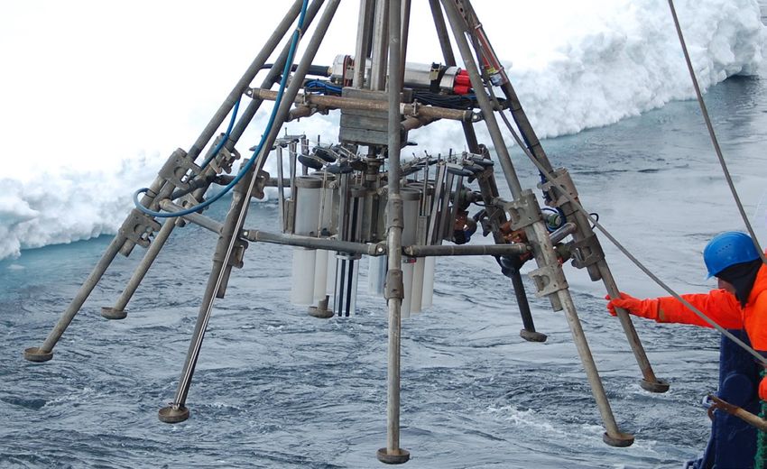
Virtually undisturbed sediment samples will be taken using a video-guided multicorer (TV-
MUC; Fig. 3.3). Various biogenic compounds from these sediments will be analysed to
estimate the input of organic matter from phytodetritus sedimentation (indicated by sediment-
bound chloroplastic pigments) and to assess activities (i.e. bacterial exoenzymatic activity) and
the total biomass (i.e. particulate proteins, phospholipids) of the smallest sediment-inhabiting
organisms. Results will help to describe ecosystem changes in the benthal of the Arctic Ocean.
Sediments retrieved by the TV-MUC will also be analysed for the quantitative and qualitative
assessment of the small benthic biota (size range: bacteria - meiofauna).
15PS114 Expedition Programme
Fig. 3.3: Sediment sampling using a video-guided multicorer (TV-MUC)
Epibenthic megafauna, defined as the group of organisms ≥1 cm, considerably contribute to
the continuous redistribution of organic matter, oxygen and other nutrients in surficial
sediments. Megafaunal organisms create pits, mounds and traces that enhance habitat
heterogeneity and thus diversity of smaller sediment-inhabiting biota in otherwise apparently
homogenous environments. In this way, erect biota enhances 3D habitat complexity and
provides shelter from predation.
Megafaunal predators control the population dynamics of their prey and therefore shape
benthic food webs and community structure. Sunken organic matter that is not converted into
benthic biomass and forwarded along food chains might be actively transported from the water
column-sediment interface into the sediment by bioturbation. Organic matter is then
degraded/recycled into nutrients and CO2. Mega- and macrofaunal species thus actively
influence biogeochemical processes at the sediment–water interface. An understanding of
megafaunal dynamics is therefore vital to our understanding of the fate of carbon at the deep
seafloor, Earth’s greatest carbon repository.
During the Polarstern expedition PS114, we will continue to study interannual dynamics of
megafaunal organisms using our towed camera system (Ocean Floor Observation System,
OFOS; Fig. 3.4). The OFOS will be towed along an established track at HAUSGARTEN station
EG-IV on the Eastern Greenland rise.
The new footage will extend our
image time series that started already
in 2002.
Fig. 3.4: Deployment of the Ocean Floor
Observation System (OFOS)
16PS114 Expedition Programme
Data and sample managment
Sample processing will be carried out at AWI. Data acquisition from the several types of
investigation will be differently time-consuming. The time periods from post processing to data
provision will vary from one year maximum for sensor data, to several years for organism
related datasets. Until then preliminary data will be available to the cruise participants and
external users after request to the senior scientist. The finally processed data will be submitted
to the PANGAEA data library. The unrestricted availability from PANGAEA will depend on the
required time and effort for acquisition of individual datasets and its status of scientific
publication.
4. PLANKTON ECOLOGY AND BIOGEOCHEMISTRY IN THE
CHANGING ARCTIC OCEAN (PEBCAO, FRAM MICROBIAL
OBSERVATORY)
N. Hildebrandt (AWI), N. Goldbach (AWI), J. Grosse (GEOMAR), N. Knüppel (AWI), B.
Staufenbiel (AWI), S. Töller (AWI), A. von Jackowski (GEOMAR), K. Metfies (AWI, not on
board), B. Niehoff (AWI, not on board), E.-M. Nöthig (AWI, not on board), I. Peeken (AWI,
not on board), A. Engel (GEOMAR, not on board), J. Bäger (AWI), L. Hufnagel (AWI), R.
Stiens (AWI), J. Wulf (MPI), C. Bienhold (AWI, MPI, not on board), B. Fuchs (MPI, not on
board)
Objectives and scientific programme
The Arctic Ocean has gained increasing attention over the past years because of the drastic
decrease in sea ice and increase in temperature, which is about twice as fast as the global
mean rate. In addition, the chemical equilibrium and the elemental cycling in the surface ocean
will alter due to ocean acidification. These environmental changes will have consequences for
the biogeochemistry and ecology of the Arctic pelagic system. The effects of changes in the
environmental conditions on the polar plankton community can only be detected through long-
term observation of the species and processes. Our studies on plankton ecology have started
in 1991 and sampling has been intensified since 2009 in the Fram Strait at ~79°N. Since then
our studies are based on combining a broad set of analysed parameters. This includes e.g.
classical bulk measurements and microscopy, optical measurements, satellite observations,
molecular genetic approaches, or cutting edge methods for zooplankton observations to study
plankton ecology in a holistic approach. Over the past 9 years we have compiled
complementary information on annual variability in plankton composition, primary production,
bacterial activity and zooplankton composition. Since 2014 the PEBCAO group is a member
of the FRAM (Frontiers in Arctic Monitoring) Ocean Observatory Team providing ground
truthing information for water column monitoring of plankton ecological, biogeochemical
parameters and microbial (prokaryotic and eukaryotic) biodiversity. We are also involved in the
development of automatic platforms and sampling technology for long-term observation in the
Arctic Ocean with main focus on the AWI HAUSGARTEN situated in the Fram Strait.
Climate induced changes will impact the biodiversity in pelagic ecosystems with concomitant
changes in carbon cycling and sequestering. At the base of the food web, we expect small
algae to gain more importance in mediating element and matter turnover as well as matter and
energy fluxes in future Arctic pelagic systems. In order to examine changes, including the
smallest fractions, molecular methods are applied to complement traditional microscopy. The
17PS114 Expedition Programme
characterization of the communities with molecular methods is independent of cell-size and
distinct morphological features. The assessment of the biodiversity and biogeography of Arctic
phyto- and bacterioplankton and associations between the two domains, will be based on the
analysis of ribosomal genes with next generation sequencing technology, and quantitative
PCR. Zooplankton organisms are affected by the changes at the base of the food web, and
this may alter the transport and modification of organic matter. Also, the zooplankton
community composition may shift due to the warmer Atlantic water in the Fram Strait. Most of
our knowledge on zooplankton species composition and distribution has been derived from
traditional multiple net samplers, which allow to sample depth intervals of several hundred
meters. Newly developed optical methods, such as the zooplankton recorder LOKI (Lightframe
On-sight Key species Investigations), and acoustic methods such as the high-frequency
acoustic device AQUAscat now continuously detect organisms floating in the water column
during vertical tows from 1,000 m depth to the surface. Simultaneously, hydrographical
parameters (i.e. pressure, salinity, temperature, oxygen concentration and fluorescence) are
being recorded. This allows the exact identification of zooplankton distribution patterns in
relation to environmental conditions.
Global change increasingly affects also pelagic microbial biogeochemistry in the Arctic Ocean.
Thus we will continue to monitor concentrations of organic carbon, nitrogen and phosphorus
as well as specific compounds like gel particles, amino acids and carbohydrates. Additionally,
we will perform rate measurements of heterotrophic bacterial production and phytoplankton
primary production. The latter will be distinguished into particulate primary production (carbon
remaining in the cells) and dissolved primary production (organic carbon subsequently
released by cells). Overall, primary production is expected to increase in the changing Arctic
Ocean, however, it is currently unclear if this leads to increased export of particulate organic
carbon or if dissolved primary production will remain at the surface fuelling heterotrophic
bacteria. By linking compound dynamics, rate measurements and bacteria, phyto- and
zooplankton community structure we will gain further insights into the flow of carbon through
Arctic food webs. Our overarching goal is to improve the mechanistic understanding of
biogeochemical and microbiological feedback processes in the Arctic Ocean and to assess the
potential for changes in the near future.
In summary during PS 114 the following topics are covered:
• Monitoring phyto-, zoo- and bacterioplankton species composition and biomass
distribution
• Monitoring biogeochemical parameters
• Investigations of selected phytoplankton groups and related biogeochemical
parameters
• Composition of organic matter in a changing Arctic Ocean
Work at sea
Biogeochemical & biological parameters from rosette samples, including the automated
filtration system for marine microbes AUTOFIM, and from remote sampling devices (RAS,
PPS)
We will sample Arctic seawater by CTD/rosette sampler at the main HAUSGARTEN/FRAM
stations at about 3-10 depths, with a focus on the photic zone.
In addition to this we will collect particulate organic matter close to the surface (~ 10 m) with
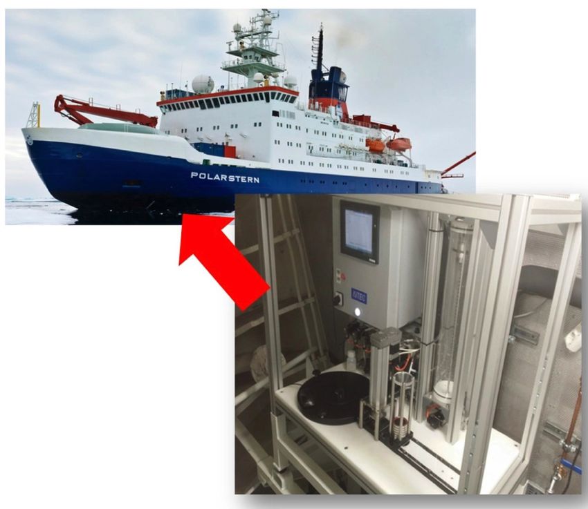
the automated filtration system for marine microbes AUTOFIM (Fig. 4.1) that is coupled to the
ship’s pump system. Using AUTOFIM we will collect seawater at regular intervals and in
parallel to the sampling via CTD. AUTOFIM allows filtration of a sampling volume up to 5 litres.
18PS114 Expedition Programme
In total 12 filters can be taken and stored in a sealed sample archive. Prior to the storage a
preservative can be applied to the filters to prevent degradation of the sample material, that
can be used for molecular or biochemical analyses. Furthermore, samples for molecular
microbiological analyses will be retrieved from remote sampling devices (RAS, PPS) to
investigate seasonal patterns in bacterial and eukaryotic community structure at
unprecedented temporal resolution.
Primary and bacterial production measurements will be performed on board using 14C
bicarbonate and 3H leucin.
Fig. 4.1: The fully automated filtration module AUTOFIM is installed on Polarstern in the bow thruster
room close to the inflow of the ships-pump system. AUTOFIM is suited to collect samples with a
maximum volume of 5 liters. Filtration can be triggered on demand or after fixed intervals.
All other samples will be filtered (partly fractionated using pore sizes of 10, 3 and 0.4/0.2 µm)
and preserved or frozen at - 20°C or - 80° C for further analyses. At the home laboratories at
AWI, MPI and GEOMAR we will determine the following parameters to describe the
biogeochemistry and the abundance and biomass distribution of eukaryotic, bacterial and
archaeal plankton groups:
• Chlorophyll a concentration (total and fractionated)
• Dissolved organic carbon (DOC)
• Particulate organic carbon (POC)
• Total dissolved nitrogen (TDN)
• Particulate organic nitrogen (PON)
• Dissolved organic phosphorus (DOP)
• Particulate biogenic silica (PbSi)
• Transparent exopolymer particles (TEP)
19You can also read