Proof of Evidence - Open Space Mr David Jones - Inquiries Procedure England & Wales Rules 2004 - Gateley
←
→
Page content transcription
If your browser does not render page correctly, please read the page content below
OFFICIAL

The Network Rail (Cambridge South Infrastructure Enhancements) Order

Proof of Evidence

                                                          Document Number: NRE8.2

Proof of Evidence – Open Space (Mr David
Jones)

(Inquiries Procedure (England & Wales) Rules 2004

January 2022
Cambridge South Infrastructure
Enhancements
Open Space Proof of Evidence

JANUARY 2022

 Prepared By:
 David Jones
 Level 1
 2 Glass Wharf
 Temple Quay
 Bristol
 BS2 0FRCF3 0EY

Arcadis Consulting (UK) Limited is a private limited company registered in England under registered number 02212959. Registered office at: 80 Fenchurch
Street, London EC3M 4BY, UK. Part of the Arcadis Group of Companies along with other entities in the UK. Regulated by RICS.

www.arcadis.com
Cambridge South Infrastructure Enhancements Project

Contents
Acronyms and Abbreviations ............................................................................................................................ 2
1      Introduction ................................................................................................................................................. 1
2      Evidence Summary..................................................................................................................................... 3
3      Legislation, Policy and Stakeholder Engagement .................................................................................. 5
4      Section 19 Application ............................................................................................................................... 9
5      Effects of Cambridge CSIE Project on Public Open Space Provision ................................................ 10
6      Response to the Objectors ...................................................................................................................... 25
7      Conclusions .............................................................................................................................................. 31

Figures
Figure 1-1 – Proposed site boundary ................................................................................................................ 10

Figure 2-2 - Temporary land take at Hobson’s Park and Long Road Sixth Form College ................................ 12
Figure 3-3 – Hobson’s Park – Land to be acquired temporarily looking West .................................................. 12

Figure 4-4 - Long Road Sixth Form College looking North – wooded area to right of railway line ................... 14

Figure 5-5 - Permanent land take at Hobson’s Park and Long Road Sixth Form College ................................ 15
Figure 6-6 - Hobson’s Park – Land to be acquired looking South from Addenbrooke’s Bridge ........................ 16

Figure 7-7 - Land to be acquired looking South towards Addenbrooke’s Bridge .............................................. 16
Figure 8-8 - Long Road Sixth Form College – Land to be Acquired looking South (wooded area East of railway
line) .................................................................................................................................................................... 18

Figure 9-9 - Potential Areas of Exchange Land ................................................................................................ 19

Figure 10-1 – Maintenance track, Hobson’s Brook and replacement land ....................................................... 26
Cambridge South Infrastructure Enhancements Project

Acronyms and Abbreviations
ALA             Acquisition of Land Act 1981
ARA             Active Recreation Area
CoCP            Code of Construction Practice
CSIE            Cambridge South Infrastructure Enhancements
CTMP            Construction Transport Management Plan
DMRB            Design Manual for Roads and Bridges
ES              Environmental Statement
GCSP            Greater Cambridge Shared Planning
NPPF            National Planning Policy Framework
NPPG            National Planning Practice Guidance
NNNPS           National Networks National Policy Statement
OLE             Overhead Line Equipment
POS             Public Open Space
PRoW            Public Right of Way
TWAO            Transport and Works Act Order
Cambridge South Infrastructure Enhancements Project

1       Introduction
1.1 Qualifications and Experience
1.1.1   This Proof of Evidence has been written by Mr. David Jones MRTPI. I am a chartered member of the
        Royal Town Planning Institute and have 36 years’ planning experience in both the public and private
        sectors. I provide a leading role on Arcadis’ planning work, as Technical Director.

1.1.2   I hold a BA (Hons) in Planning Studies and a Diploma in Town Planning from Oxford Brookes
        University and an Urban Design Diploma from Gloucester College of Science and Technology.

1.1.3   During my professional career I have worked on a full range of planning work, including the delivery of
        planning consents across the main consenting regimes in England and Wales, the preparation of
        planning and strategy documents and responses to consultation documents. I have undertaken
        appeals, policy promotion and representation work on numerous development schemes and have
        acted as an expert witness at Public Inquiries and Examinations in Public on behalf of
        clients/employers. I have also undertaken, through the statutory planning process and project work,
        major public consultation and participation exercises, stakeholder workshops and forum events.

1.1.4   I have been engaged by National Highways as a planning consultant on the Lower Thames Crossing
        Nationally Significant Infrastructure Project, a major highway scheme to provide an additional tunnel
        crossing of the River Thames east of London. As part of this work, I have led the commissioning of an
        Open Space, Sports and Recreation Needs Assessment and its findings in relation to the acquisition
        of public open space and the identification of replacement land in accordance with legislative
        provisions.

1.1.5   My role on the Cambridge South Infrastructure Enhancements (CSIE) Project has been to provide
        technical support to Network Rail in the drafting and review of the Public Open Space Assessment.
        For this purpose, I have visited the location of the CSIE Project and am familiar with the area and the
        policy context within which it has been considered.

1.2 Scope and Structure of Evidence
1.2.1   I will provide evidence on Public Open Space matters, to include:

        a) A Summary of Evidence is provided in section 2, followed by an outline of the legislative and
           policy framework, along with the engagement undertaken with key stakeholders in section 3.

        b) Section 4 provides a brief outline of Section 19 Application procedures undertaken by Network
           Rail in relation to the acquisition of open space land.

        c)    A summary of Public Open Space Assessment work undertaken to date, with particular reference
             to the loss of existing Public Open Space (POS), the identification of potential areas of exchange
             land and the methodology used in assessing the preferred replacement site. This is presented in
             sections 5 of my evidence.

        d) A response to the objections received in respect of the assessment scoring used in the selection
           of the preferred area of replacement land, the methodology and conclusions of the POS
1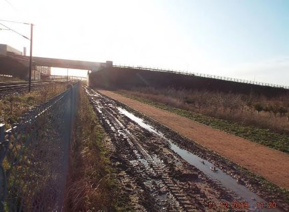
Cambridge South Infrastructure Enhancements Project

            Assessment and detailed matters relating to landscape, biodiversity, accessibility, spoil deposition
            and the bringing into use of the exchange land. This is presented in section 6 of my evidence.

       e) Brief conclusions on the overall findings of the POS Assessment and its compliance with the
          legislative framework and established policy and guidance in support of the CSIE Project are set
          out in section 7 of my evidence.

2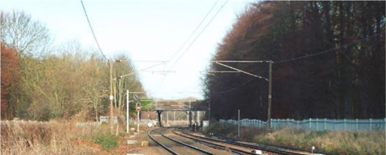
Cambridge South Infrastructure Enhancements Project

2       Evidence Summary
2.1.1   In my evidence I deal with all matters relating to public open space provision for the CSIE Project.

2.1.2   The baseline review for the Project has identified two areas of public open space (POS) within the
        Transport and Works Act Order (TWAO), (Document Reference B1) site boundary that may be
        impacted during the construction and/or operational phases of the CSIE Project. For construction
        purposes, two areas of POS are required temporarily at Long Road Sixth Form College (350 sqm)
        and Hobson’s Park (57,826 sqm). For the operational phase, POS totalling 20,439 sqm is proposed
        within Hobson’s Park and 303 sqm POS within Long Road Sixth Form College, representing a total
        permanent land-take of 20,742 sqm.

2.1.3   The legislative framework for land that is to be compulsory acquired by statutory undertakers for their
        undertakings is provided by the Acquisition of Land Act (ALA) 1981 (Document Reference B12).
        Section 19(1) of the Act has particular relevance to this Project, requiring exchange land to be
        provided that is no less in area and is equally advantageous to the persons entitled to rights over such
        land and to the public. As there is no requirement under the Act to consider the provision of exchange
        land for temporary works, the focus of my evidence is on land to be permanently acquired within the
        two identified areas of POS.

2.1.4   National planning policy and guidance in relation to open space provision and its replacement as a
        result of new development is provided in the National Planning Policy Framework (NPPF, Ministry of
        Housing, Communities and Local Government, 2019 (Document Reference D1); National Networks
        National Policy Statement (NNNPS) Department for Transport December, 2014 (Document Reference
        D5) and National Planning Practice Guidance (NPPG), Ministry of Housing, Communities and Local
        Government 2014 (Document Reference D4).

2.1.5   At a local level, the Adopted Cambridge Local Plan, 2018 (Cambridge City Council), (Document
        Reference D6) provides specific policy guidance on the provision of replacement open space and the
        Adopted South Cambridgeshire Local Plan, 2018 (South Cambridgeshire District Council), (Document
        Reference D8) allocates areas of open space, though none of the allocated sites are more closely
        located to the areas of POS to be lost than the proposed replacement site.

2.1.6   In accordance with the methodology set out in Chapter 2 (EIA methodology) of the accompanying
        Environmental Statement (Document Reference NR16) to the TWAO and the ‘Design Manual for
        Roads and Bridges’ (DMRB) LA 112 (Highways England et al, 2019), (Document Reference D62), an
        assessment has been undertaken to consider the impacts of the CSIE Project on the areas of POS to
        be acquired, both temporarily and permanently (the Assessment). Whilst the latter publication sets out
        the requirements for assessing and reporting the environmental effects on population and health from
        the construction, operation and maintenance of highways projects, it is considered that the Manual
        provides appropriate guidance for railway projects, having been used elsewhere by Network Rail in
        the absence of more relevant guidance.

2.1.7   In relation to permanent land-take, the ES has concluded that in relation to Hobson’s Park, following
        the return of the land to POS on completion of construction works, the mitigation measures proposed,
        the significance of effect is considered to be not significant. In the case of the Long Road Sixth Form
        College, in view of the mitigation measures proposed within the ES, the significance of effects is also
        considered to be not significant.

3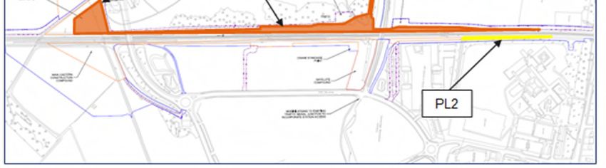
Cambridge South Infrastructure Enhancements Project

2.1.8   For the two areas of permanent land to be acquired, in the case of Hobson’s Park, the Public Open
        Space Assessment Report (June 2021) (Document Reference NR19) notes the relatively small area
        of land affected, the restricted accessibility to the area by the public, the limited amenity value due to
        its proximity to the railway corridor and its separation from the wider area of the Park. For the smaller
        area of land to be acquired at the Long Road Sixth Form College, the Assessment notes the relatively
        small area of land to be used, its limited amenity value and the restricted accessibility to the area by
        the public, due to its proximity to the existing operational railway corridor and heavy vegetation.

2.1.9   In relation to the two areas of POS at Hobson’s Park and Long Road Sixth Form College required
        temporarily for the provision of temporary access and as a site compound, the ES has concluded that
        in relation to landscape character and visual amenity, the impacts on both areas are not significant.

2.1.10 In accordance with the Assessment above, Network Rail proposes to provide replacement land,
       though in line with the legislative provisions, consideration of replacement land is only required for
       POS which is to be permanently acquired. In the absence of replacement land directly adjacent to the
       CSIE Project suitable for acquisition as POS, Network Rail has been required to consider the use of
       agricultural land parcels to the south of Addenbrooke’s Road and the Cambridge Biomedical Campus.
       Four potential areas of exchange land have been assessed in line with the criteria set out for the
       provision of replacement land, based on national guidance, local planning policy and relevant case
       law.

2.1.11 The results of this Assessment are that the proposed replacement site immediately to the south of
       Hobson’s Park, covering an area of 20,840 sqm scored highest against the three assessment criteria
       of Quality, Quantity and Accessibility, as the most suitable site to mitigate for the permanent loss of
       POS in Hobson’s Park and Long Road Sixth Form College as a result of the CSIE Project, thereby
       meeting the provisions of the ALA 1981.

4
Cambridge South Infrastructure Enhancements Project

3       Legislation, Policy and Stakeholder Engagement
3.1 Legislative and Policy Background
Legislation

3.1.1   The Acquisition of Land Act 1981 (Document Reference B12) provides the primary legislative
        framework for land that is compulsory acquired by statutory undertakers for their undertakings.
        Section 19 states that where a compulsory purchase order (including a TWAO made under the
        Transport and Works Act 1992) (Document Reference B1) authorises the compulsory acquisition of
        open space, the order shall be subject to Special Parliamentary Procedure (SPP) unless the
        Secretary of State is satisfied, and certifies that, one of the exceptions prescribed by section 19(1) of
        the 1981 Act applies.

3.1.2   These exceptions are:

        i.      ‘that exchange land has been provided that is no less in area and is equally advantageous for
                use to the persons, if any, entitled to rights over such land, and to the public, and that the land
                given in exchange has been or will be vested subject to the rights attached to the land
                purchased’ (s. 19(1)(a)); or

        ii.     that the land is being purchased to secure its preservation or improve its management (s.
                19(1)(aa)); or

        iii.    that the land does not exceed 250 square yards (which converts to approximately 209 square
                metres (m2)) in extent or is required for the widening or drainage of an existing highway and
                that the giving in exchange of other land is unnecessary, whether in the interests of the
                persons, if any, entitled to rights over such land or in the interests of the public’ (s. 19(1)(b)).

3.1.3   It is the first exception, s.19(1)(a), that is relevant to the present proceedings and which has been the
        basis for the application made for a certificate for the provision of replacement land in exchange for
        the loss of open space.

3.1.4   Section 28 of the 1981 Act, entitled “acquisition of rights over land by the creation of new rights”
        provides that Schedule 3 of the Act applies to the compulsory acquisition of rights over land by the
        creation of new rights. Schedule 3 of the Act, in turn, states in paragraph 6(1) that (as far as is
        relevant):

        ‘In so far as a compulsory purchase order authorises the acquisition of a right over land forming part
        of a common, open space or fuel or field garden allotment, it shall be subject to special parliamentary
        procedure unless the Secretary of State is satisfied –

        (a) that the land, when burdened with that right, will be no less advantageous to those persons in
            whom it is vested and other persons, if any, entitled to rights of common or other rights, and to the
            public, than it was before..’

5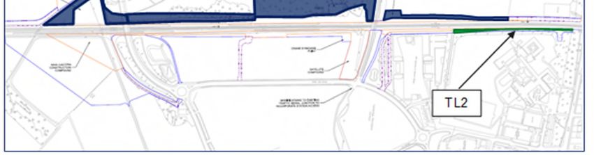
Cambridge South Infrastructure Enhancements Project
Policy
3.1.5 National planning policy and guidance in relation to open space and the provision of replacement land
as a result of new development affecting open space land is provided in the following documents:
National Planning Policy Framework (NPPF), Ministry of Housing, Communities and Local
Government, (2021) (Document Referenced D1).
National Networks National Policy Statement (NNNPS), Department for Transport, (December
2014) (Document Reference D5) and
National Planning Practice Guidance (NPPG), Ministry of Housing, Communities and Local
Government, “Open space, sports and recreation facilities, public rights of way and local green
space” (March 2014) (Document Reference D5).
3.1.6 Paragraph 99 of the NPPF provides, in essence, that existing open space should not be built on.
However, it is subject to exceptions, including an exception where the loss resulting from the
proposed development would be replaced by equivalent or better provision in terms of quantity and
quality in a suitable location:
‘Existing open space, sports and recreational buildings and land, including playing fields, should
not be built on unless:
b) the loss resulting from the proposed development would be replaced by equivalent or
better provision in terms of quantity and quality in a suitable location…’
3.1.7 I am advised that in R(oao Brommell) v Reading BC [2018] EWHC 3529 (Admin)), (Document
Reference B41), the Appeal Court provided the following clarity regarding the quantity and quality of
land to be replaced, as a result of the development of a primary school, associated multi-use games
area and parking facilities on part of Mapledurham Playing Fields, a recreational space in Caversham,
Reading:
‘Whether or not the provision is equivalent or better must be judged in terms of both quantity and
quality. The word “and” simply makes clear that both quality and quantity are relevant parameters in
judging whether provision is “equivalent or better”. So the overall requirement is that the open space
land lost must be made up for, and whether or not that requirement is met is a matter of planning
judgment, having regard to both the quantity of what is to be provided and the quality, but allowing (in
an appropriate case) for one to be set off against the other.’
3.1.8 Paragraph 5.166 of the NNNPS provides similar guidance to the NPPF, stating that, ‘existing open
space, sports and recreational buildings and land should not be developed unless the land is surplus
to requirements or the loss would be replaced by equivalent or better provision in terms of quantity
and quality in a suitable location. Paragraph 5.181 goes on to say that ‘any exchange land should be
at least as good in terms of size, usefulness, attractiveness, quality and accessibility’.
3.1.9 The NPPG acknowledges that open space, ‘can provide health and recreation benefits to people
living and working nearby; have an ecological value and contribute to as well as being an important
6Cambridge South Infrastructure Enhancements Project
part of the landscape and setting of built development, and an important component in the
achievement of sustainable development.’
3.1.10 Local planning policy in relation to open space provision is referred to within the development plans of
both affected local planning authorities:
Cambridge Local Plan, Cambridge City Council (Adopted 2018). (Document Reference D6).
South Cambridgeshire Local Plan, South Cambridgeshire District Council (Adopted 2018).
(Document Reference D7)
3.1.11 Policy 67 of the Adopted Cambridge City Council Local Plan seeks to protect open space land,
explaining that:
‘Development proposals will not be permitted which would harm the character of, or lead to the loss
of, open space of environmental and/or recreational importance unless:
a) the open space can be satisfactorily replaced in terms of quality, quantity and access with an
equal or better standard than that which is proposed to be lost; and
b) the re-provision is located within a short walk (400m) of the original site
In the case of school, college and university grounds, development may be permitted where it meets a
demonstrable educational need and does not adversely affect playing fields or other formal sports
provision on the site. Where replacement open space is to be provided in an alternative location, the
replacement site/facility must be fully available for use before the area of open space to be lost can be
redeveloped’.
3.1.12 Paragraph 7.47 of the supporting text states that, ‘there is a clear presumption against the loss of
open space of environmental or recreational importance. However, there may be circumstances
where development proposals can enhance the character, use and visual amenity of open space, and
provide ancillary recreational facilities, such as changing facilities, or materially improve the
recreational or biodiversity value of the site.’
3.1.13 Paragraph 7.48 reads, ‘replacement sites/facilities should be no more than a short walk (400m) from
the site that is to be replaced unless it can be proved that a more accessible area of open space can
be provided. Replacement sites/facilities should not increase any identified deficiencies in open space
in the ward where the original site is located. Consideration should also be given to how they link with
the wider ecological network and enhance biodiversity.’
3.1.14 The Adopted South Cambridgeshire Local Plan has identified, under Policy SC/1 (Allocation for Open
Space) land to the south of Granhams Road, Great Shelford (SC/1 (2e)) as a new site for open space.
Whilst the site is the closest site allocation for open space provision in relation to the sites impacted
by the CSIE Project, its distance, at over 1km from the affected area of POS at Hobson’s Park has
discounted it from further consideration as potential replacement land.
7Cambridge South Infrastructure Enhancements Project
3.2 Stakeholder Engagement
3.2.1 Consultation has been undertaken by Network Rail with the landowner and Cambridge City Council
(prospective lessee) in relation to the POS affected by the CSIE Project within Hobson’s Park, along
with discussions with the Sixth Form College regarding the land-take requirements affecting their land.
3.2.2 Consultation with the Greater Cambridge Shared Planning (the shared planning service for South
Cambridgeshire District Council and Cambridge City Council) (GCSP) has taken place regarding the
baseline conditions for the affected areas and confirmation that the areas of land affected by the CSIE
Project would be classed as POS. In its original representation to the Secretary of State, GCSP
described the selected replacement land as “…the most appropriate location for exchange land”
although it stated that “the success of the area for mitigation will depend on the landscaping details
secured through conditions”.
3.2.3 Subsequently an objection was received from Cambridge City Council (OBJ 23) to the proposed
development which includes the following principal matters relating to POS:
Further information to be provided on the landscaping and biodiversity features, and the
accessibility and safety of crossing Addenbrooke’s Road.
The exchange land must be laid out and available for use before the existing public open
space for the development commences.
The temporary use of Hobson’s Park must be justified in terms of the area of land and the
duration for which it is required.
There must be no spoil permanently placed within areas of public open space.
The use of existing public open space for the creation of new access routes and temporary
work required must be the minimum required and must be justified.
The layout of new routes across the public open space should consider the impact on the
remaining green spaces, and any changes to the management regime or the use of spaces
for recreation.
3.2.4 These objections are addressed in section 6 below.
3.2.5 The proposed landscape scheme to be implemented on the exchange land south of Hobson’s Park
will be developed in consultation with Cambridge City Council, South Cambridgeshire District Council,
Long Road Sixth Form College and the Hobson’s Conduit Trust.
8Cambridge South Infrastructure Enhancements Project
4 Section 19 Application
4.1.1 Network Rail submitted an application to the Secretary of State for Transport on 23rd August 2021 for
a certificate under section 19(1) (a) and paragraph 6(1) (a) of Schedule 3 to the Acquisition of Land
Act 1981 in order to authorise the purchase of land and new rights over land forming part of open
space land.
4.1.2 Subsequently, the Secretary of State for Levelling Up Housing & Communities confirmed his intention
on 7th October 2021 to give the certificate in accordance with the provisions of section 19(2) and
Schedule 3, paragraph 6(3). However, before reaching a decision, he was required to direct Network
Rail to give public notice of this intention before reaching a decision, to afford an opportunity for
representations and objections to be made.
4.1.3 Accordingly, public notification of the Section 19 Application was published in the Cambridge News on
1st and 8th November 2021, along with site notices and notice served on those with an interest in the
affected open space land. The time period for objecting to the proposed application ended on 22nd
November 2021.
4.1.4 Only one ‘objection’ was received during this period from Mr Meed (Rep 11). However, the written
representation related to the possible impacts on the use of land south of Addenbrooke’s Road as a
compound would have on this land on ecological grounds rather than any specific open space land
issues. The Department for Communities and Levelling Up is currently liaising with Mr Meed to
confirm that this ‘objection’ does not specifically relate to the Section 19 application.
4.1.5 Consequently, it is Network Rail’s view that this does not constitute an ‘objection’ to the Section19
Application but rather as a representation in respect of the Scheme itself. For this reason, this is not
considered to be an ‘objection’ made on relevant grounds and I do not propose to deal with it as part
of my Proof of Evidence which focusses on open space matters.
9Cambridge South Infrastructure Enhancements Project
5 Effects of Cambridge CSIE Project on Public
Open Space Provision
5.1.1 In this section I set out evidence relating to the Public Open Space (POS) receptors impacted as a
result of the CSIE Project, the identification of exchange land and a justification for the proposed
replacement sites in line with the assessment methodology.
5.1 Assessment Approach
5.1.2 The POS Assessment within the Public Open Space Assessment Report (June 2021) (Document
Reference NR19) considered the impacts of the CSIE Project on areas of identified POS where
temporary or permanent land acquisition is required. The Assessment has been based on the study
area shown in Figure 1 below, delineated by the site boundary of the TWAO.
Figure 1-1 – Proposed site boundary
10Cambridge South Infrastructure Enhancements Project
5.1.3 The Assessment has considered the impacts on areas of identified POS where temporary or
permanent land acquisition is required for the CSIE Project in relation to the following aspects:
Location and type of POS affected by the proposed development e.g. common land, village
greens, open green space, allotments, sports pitches etc.;
The amount of land which will be acquired or affected by the proposed development (during both
the construction and operational phases);
Quality of the land for use as public amenity; and
Any current accessibility restrictions to the land.
5.1.4 The method of assessment and reporting of significant effects has been a qualitative one based on
the methodology set out in Chapter 2 (EIA methodology) of the accompanying Environmental
Statement (Document Reference NR16) to the TWAO and has involved the following steps:
Categorisation of importance (sensitivity) of receptor (existing POS).
Categorisation of magnitude of the impact; and
Assessment of the significance of the effect based on the importance of the receptor (existing
POS) and magnitude of the impact.
5.1.5 The level of sensitivity has been determined using the criteria set out in Table 3.11 of the ‘Design
Manual for Roads and Bridges’ (DMRB) LA 112 (Document Reference D62) for community land and
assets, with professional judgement used to assign the POS to the most appropriate level of
sensitivity.
5.2 Affected Public Open Space
5.2.1 The baseline review for the POS Assessment identified the following areas of POS within the TWAO
site boundary that may be impacted during the construction and operational phases of the CSIE
Project. These relate to both temporary and permanent areas of land-take, as described below:
Temporary Use of Public Open Space
5.2.2 Two areas of POS will be required to accommodate temporary construction activities. The initial
application proposals for these are shown indicatively in Figure 2 below at Hobson’s Park (TL1 -
shaded blue) and Long Road Sixth Form College (TL2 - shaded green).
11Cambridge South Infrastructure Enhancements Project
Figure 2-2 - Temporary land take at Hobson’s Park and Long Road Sixth Form College
Hobson’s Park
5.2.3 An area of 57,826 sqm out of a total Park area of 482,880 sqm (approximately 12%) is required within
Hobson’s Park to provide temporary access and use as a site compound for construction of the
western station areas including storage and sorting areas for excavated materials prior to removal off-
site. The POS affected does not form part of a playing field, common land or allotment.
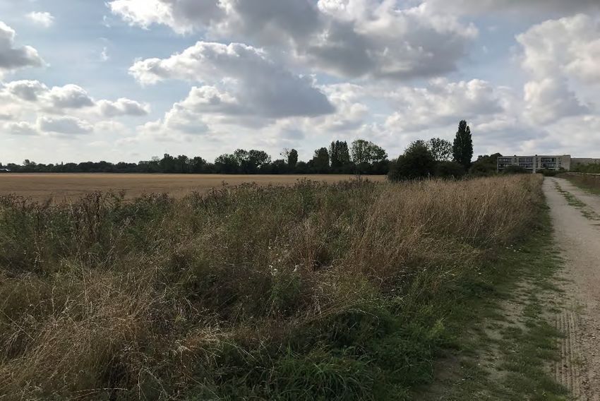
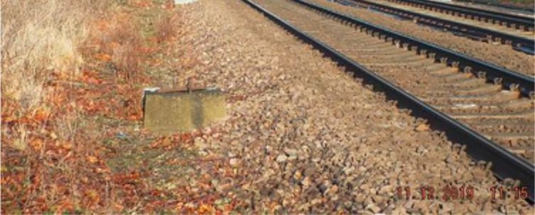
Figure 3-3 – Hobson’s Park – Land to be acquired temporarily looking West
12Cambridge South Infrastructure Enhancements Project
5.2.4 It should be noted that the area required, as depicted in Fig 2-1 above, has been reduced from the
area originally proposed for temporary use (170,503 sqm) to 57,826 sqm. This reduction followed the
appointment of Network Rail’s contractor and objections received from the local community.
5.2.5 The area of POS directly affected by the proposed development is used on a daily basis by members
of the public for recreational purposes. However, the revised proposals ensure retention of as much of
the existing open space and path network as possible thereby reducing any adverse effects upon the
amenity of park users. The remaining areas of Hobson’s Park POS will not be affected or acquired
temporarily as part of the proposed development and will remain available to the public during the
construction phase.
5.2.6 A qualitative assessment of the impacts on landscape character and visual amenity resulting from the
construction of the proposed development has been undertaken within the ES.
5.2.7 In order to avoid or prevent significant adverse effects occurring, or reduce their significance on
landscape character and visual amenity receptors during the construction period, an outline Code of
Construction Practice (CoCP) Part A has been submitted with the application and further detail will
follow in a CoCP Part B, incorporating the following best practice measures:
Avoiding excessive temporary land take during construction, including Hobson’s Park, to
allow retention of as much of the existing open space and path network as possible
Avoiding excessive temporary land take during construction by using existing maintenance
tracks as haul / construction access routes
Appropriate designs of construction-fencing and hoarding surrounding construction areas
Measures to limit construction site lighting to that required for the activity
Reducing the adverse visual effects on users of publicly accessible areas and routes by
restricting temporary material stockpile heights
Locating material stockpiles, construction parking and other visually obtrusive non-location
specific activities away from sensitive receptors
The careful lifting, temporary heeling in, protection and management of areas of existing
immature native tree and shrub planting, including Hobson’s Park
Protecting remaining tree and shrub vegetation with temporary fencing
Reinstating tree and shrub planting, hedge vegetation and grass seeding with new
replacement planting/seeding
5.2.8 In assessing the residual effects from construction activity on landscape character, the ES concludes
(based on the original, more extensive land take proposed) that the impacts would be reduced with
the above mitigation measures, such that there is likely to be a moderate / minor adverse effect of
moderate sensitivity which is not significant.
5.2.9 In terms of visual amenity, the ES considers that in relation to publicly accessible open spaces such
as Hobson’s Park there would be adverse impacts to the visual amenity of users, though this would
13Cambridge South Infrastructure Enhancements Project
be short-term and reversible. In line with the mitigation measures above the assessment within the ES
concludes (again, based on the original, more extensive land take proposed) that there is, fat worst
likely to be a moderate / minor adverse effect of moderate sensitivity and therefore not significant.
Long Road Sixth Form College
5.2.10 An area of 2,761 sqm, out of a total site area of some 42,500 sqm (6.4%) was previously required to
provide temporary access and use as a site compound for construction of the Up Loop line which will
pass through the eastern side of the proposed new Cambridge South Station. However, the
temporary vehicular access on the east side of the railway is no longer required and the only main
construction requiring access from the east is for 4 overhead line equipment (OLE) gantry
foundations. The remaining track works will be undertaken from the railway corridor. The required
temporary land-take has therefore been reduced to 350 sqm (0.8%).
5.2.11 The site is a wooded area within the grounds of the Long Road Sixth Form College and is designated
as protected open space within the Cambridge Local Plan. The POS affected does not form part of a
playing field, common land or allotment.
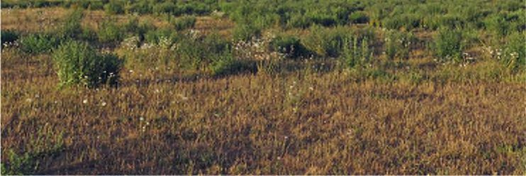
Figure 4-4 - Long Road Sixth Form College looking North – wooded area to right of railway line
5.2.12 As described in paragraphs 4.2.6 – 4.2.9 above in relation to the impacts arising from construction of
the proposed development, the ES concludes (based on the original, more extensive land take
proposed) that in terms of landscape character there is, at worst likely to be a moderate / minor
adverse effect of moderate sensitivity and therefore not significant.
14Cambridge South Infrastructure Enhancements Project
5.2.13 In relation to visual amenity, there would be adverse impacts to the visual amenity of users of the
railway line on its approach to Cambridge, though this would be short-term and reversible. With the
construction-phase mitigation measures in paragraph 4.2.7 above, the ES concludes (again, based on
the original, more extensive land take proposed) that there is, at worst, likely to be a moderate / minor
adverse effect of moderate / low sensitivity, and therefore not significant.
Permanent Land Take
5.2.14 Areas of POS at both Hobson’s Park and the Long Road Sixth Form College will also be acquired on
a permanent basis to accommodate the operational activities of the proposed development. These
are shown indicatively in Figure 5 below, referenced as PL1 (Hobson’s Park - Orange) and PL2 (Long
Road Sixth Form College - Yellow).
Figure 5-5 - Permanent land take at Hobson’s Park and Long Road Sixth Form College
Hobson’s Park
5.2.15 The land to be permanently acquired relates principally to Hobson’s Park (PL1) where there will be a
permanent loss of approximately 20,439 sqm of POS, out of a total Park area of 482,880 sqm
(approximately 4.2%).
5.2.16 This area of land forms part of a wider area of informal open space created in connection with the
adjacent Clay Farm residential development to the west of the POS. The Park forms part of Great
Kneighton Bird Reserve, an area of rough grassland and lakes, providing a green wildlife corridor
extending from Shelford and Trumpington, along Hobson’s Brook to Brooklands Avenue.
15Cambridge South Infrastructure Enhancements Project
Figure 6-6 - Hobson’s Park – Land to be acquired looking South from Addenbrooke’s Bridge
Figure 7-7 - Land to be acquired looking South towards Addenbrooke’s Bridge
5.2.17 Hobson’s Park contains a number of permissive paths providing connectivity to an area to the north of
the Guided Busway, known as the Active Recreation Area (ARA) beneath the Guided Busway bridge
(Addenbrooke’s Bridge). A cross section of the general public use the area, including dog walkers,
16Cambridge South Infrastructure Enhancements Project
cyclists and runners as well as workers from the Cambridge Biomedical Campus located to the east of
the POS.
5.2.18 The POS to be acquired within the Park forms a narrow strip of land, ranging from approximately 5m
to 13m wide, bordered by a wire mesh fence running along the railway line immediately to the west
and a linear embankment to the east. This measures some 20m wide at its narrowest, to some 72m at
its widest and forming 2m-3m high hillocks planted with saplings, providing a physical and visual
screen between this area of POS and the wider area of the Park. The area, which is flat in nature, is
characterised predominately by scrub land with a track running through the area used by Cambridge
City Council to maintain the Park, thus limiting the public’s use of the area as POS. (Network Rail will
be securing a maintenance right of access through the TWAO).
5.2.19 In view of the proximity of this POS to the adjoining operational railway corridor, the presence of a
maintenance track running through the site and is separation from the wider area of POS limits the
ability of the public to use it. This is particularly so given the more favourable adjoining land within
Hobson’s Park, offering limited amenity value in comparison to the wider area of POS available to the
public. The acquisition of the POS land will not affect the use of the wider area of POS during the
operational phase and the public recreational activities will continue following acquisition of the land.
5.2.20 The assessment within the ES has concluded that as there are no significant adverse residual effects
to any of the identified landscape character or visual amenity receptors (ES Chapter 13 – Landscape
and Visual) and the limited impacts in respect of recreational amenity (ES Chapter 15 – Population
and Human Health) (as described in the preceding paragraph) these effects are considered to be not
significant.
5.2.21 As Network Rail (as promoter of the TWAO) has not yet been able to reach agreement with the owner
(and their prospective lessee) of the POS within Hobson’s Park either prior to submission of or during
the process for determination of the Order, it has been necessary to include in the TWAO compulsory
acquisition powers over the POS required for the permanent works.
Long Road Sixth Form College
5.2.22 A much smaller area of POS, 303 sqm out of a total site area 42,500 sqm (0.007%), is to be
permanently acquired within the grounds of the Long Road Sixth Form College (PL2). The area is
heavily wooded and vegetated and runs directly parallel to the boundary of the operational railway,
which restricts the use of the space for public recreation. The POS is of low value as it is
predominately woodland and scrub vegetation bordered by the railway to the west. It is also screened
from the remaining areas of POS by existing woodland and vegetation which forms the border
between the railway and the college grounds.
17Cambridge South Infrastructure Enhancements Project
Figure 8-8 - Long Road Sixth Form College – Land to be Acquired looking South (wooded area East
of railway line)
5.2.23 As with Hobson’s Park, the assessment within the ES has concluded that as there are no significant
adverse residual effects to any of the identified landscape character or visual amenity receptors (ES
Chapter 13 – Landscape and Visual) and the limited impacts in respect of recreational amenity (ES
Chapter 15 – Population and Human Health) these effects are considered to be not significant.
5.3 Replacement Public Open Space
5.3.1 The area adjoining the CSIE Project at Hobson’s Park is bounded by the existing railway line to the
east, with Cambridge Biomedical Campus beyond, the Clay Farm residential development to the
west, the raised embankment of Addenbrooke’s Road to the south and open farmland to the north.
The Long Road Sixth Form College grounds are bounded to the north by Long Road, east and south
by the Cambridge Biomedical Campus and on the west by the existing railway.
5.3.2 Network Rail has therefore been required to consider the use of agricultural land parcels to the south
of Addenbrooke’s Road and the Cambridge Biomedical Campus within the Cambridge Green Belt for
replacement Public Open Space provision.
5.3.3 Four areas of exchange land have been considered potentially suitable for the provision of
replacement POS, compliant with the requirements of the 1981 Act (Document Reference B12) as
detailed in Table A below and delineated in Figure 9. Details of how the merits of these areas have
been appraised are set out in section 4.4. below.
18Cambridge South Infrastructure Enhancements Project
Table A Potential Areas of Exchange Land
Exchange Description
Land No.
EL1 Agricultural land to the south-east of Addenbrooke’s Road adjacent to the
eastern boundary of the railway
EL2 Agricultural land to the south of Dame Mary Archer Way
EL3 Agricultural land to the south-east of Nine Wells Local Nature Reserve
EL4 Agricultural land to the south of Addenbrooke’s Road and south-west of
Hobson’s Brook
Figure 9-9 - Potential Areas of Exchange Land
5.4 Replacement Land Assessment Methodology
5.4.1 The four identified areas of potential exchange land were assessed against the following criteria to
establish their suitability in mitigating the impact of the permanent loss of POS brought about by the
CSIE Project during its operation. The criteria reflect and are informed by the criteria set out for
replacement land in national guidance and local planning policy.
1) Quantity: Site area of the replacement land compared to that lost as a result of the proposed
Development
2) Quality: Usefulness and attractiveness of the replacement land compared to that lost as a result of
the proposed Development
19Cambridge South Infrastructure Enhancements Project
3) Accessibility: Distance of the replacement land from the site of the proposed Development
5.4.2 Each of the above criteria was assessed against the following values and an associate score
attributed as set out in Table B below.
Table B Criteria Scoring Matrix
Value Description Score
Excellent Provides a major improvement/enhancement above the current situation 5
Good Provides a minor improvement/enhancement above the current situation 4
Satisfactory Matches the existing situation 3
Poor Provides a minor reduction/detraction from the current situation 2
Very poor Provides a major reduction/detraction from current the situation 1
5.4.3 The higher the assessment score, the more suitable the site is as replacement land for the loss of
POS in Hobson’s Park (PL1) and within the grounds of Long Road Sixth Form College (PL2).
5.4.4 The matrix below sets out the results of the assessment of the potential exchange land sites against
the criteria and scoring matrix with relevant commentary to explain the assessment score. My
assessment of the scoring matrix in Table C below differs from that shown in the Public Open Space
Assessment Report, with a lower score of 3 shown for Site EL4 compared to 4 in terms of the
Accessibility criterion, as the proposed replacement land is considered by me to match the existing
situation rather than as a ‘minor improvement’ on the current situation.
Table C Exchange Land Assessment
Exchange Quantity Quality Accessibility Total
Land No.
EL1 The site is Currently an Direct connection to 7
equivalent in size to agricultural field, flat National Cycle Network
the combined area and level, located on Route 11 and the Genome
of land-take at the east side of the Path but located on the
Hobson’s Park and railway with no direct east side of the railway so
the Long Road connectivity to no connectivity to the area
Sixth Form College Hobson’s Park and the of land-take at Hobson’s
grounds. Long Road Sixth Form Park and the Long Road
College grounds which Sixth Form College
detracts from the grounds which detracts
= Satisfactory (3) current situation to a from the current situation to
minor extent. a minor extent.
= Poor (2) = Poor (2)
EL2 The site is larger Currently an Direct connection to the 9
than the combined agricultural field, flat Genome Path and Footpath
area of land-take at and level, located on 198/2 but located on the
Hobson’s Park and the east side of the east side of the railway so
20Cambridge South Infrastructure Enhancements Project
Exchange Quantity Quality Accessibility Total
Land No.
the Long Road railway with no direct no connectivity to the area
Sixth Form College connectivity to of land-take at Hobson’s
grounds. Hobson’s Park and the Park and the Long Road
Long Road Sixth Form Sixth Form which detracts
College grounds which from the current situation to
= Excellent (5) detracts from the a minor extent.
current situation to a
= Poor (2)
minor extent
= Poor (2)
EL3 The site is larger Currently an Not directly connected to a 8
than the combined agricultural field, flat PRoW or cycle track and
area of land-take at and level, located on located south of the Nine
Hobson’s Park and the east side of the Wells Local Nature
the Long Road railway with no direct Reserve. No connectivity to
Sixth Form College connectivity to area of land-take at
grounds. Hobson’s Park and the Hobson’s Park and the
Long Road Sixth Form Long Road Sixth Form
College grounds which College grounds. The lack
= Excellent (5) detracts from the of accessibility is a major
current situation. detraction from the current
situation.
= Poor (2)
= Very poor (1)
EL4 The site is Currently an Not directly connected to a 10
marginally larger agricultural field, flat PRoW or cycle track but
than the combined and level, located on will be directly connected to
area of land-take at the west side of the the land take at Hobson’s
Hobson’s Park and railway, directly south Park. This includes a new
the Long Road of and physically accommodation bridge and
Sixth Form College connected to Hobson’s footbridge over Hobson’s
grounds. Park (in contrast to Brook to be provided as
land on the east side part of the CSIE Project.
= Good (4)
of the railway). Access from Clay Farm will
be required to cross
= Satisfactory (3)
Addenbrooke’s Road at this
point.
= Satisfactory (3)
5.4.5 The four identified potential exchange sites have been assessed using the criteria and scoring matrix
detailed in Table B and Table C above. Pursuant to this assessment replacement site EL4 scored
highest overall, with a summary of the findings provided below against each of the three assessment
criteria:
21Cambridge South Infrastructure Enhancements Project
Quantity: Site area of the replacement land compared to that lost as a result of the proposed
Development
5.4.6 The CSIE Project will result in the permanent acquisition of 20,439 sqm. POS within Hobson’s Park
and 303 sqm at Long Road Sixth Form College grounds, providing an overall land-take of 20,742 sqm.
As compensation for this, a total of 20,840 sqm POS is to be provided as replacement land, which is
considered to represent a minor improvement/enhancement above the current situation for site EL4.
Potential exchange sites EL2 and EL3 which provide a greater area of exchange land score more
highly, with larger areas of replacement land. Exchange site EL1 provides an equivalent land area in
exchange and scores 3 (matching the existing situation).
5.4.7 Although sites EL2 and EL3 have been scored more highly as a result of their capacity to provide
more replacement land than is being lost, I am advised that compulsory acquisition is only likely to be
justified to acquire a broadly comparable level of land and as such, it may be considered that those
sites are not truly preferable for that reason.
Quality: Usefulness and attractiveness of the replacement land compared to that lost as a result of the
proposed Development
5.4.8 As in the case of potential exchange sites EL1, EL2 and EL3, proposed exchange site EL4 comprises
an agricultural field that is flat and level. However, the location of site EL4 on the west side of the
railway line, directly south of the POS to be acquired within Hobson’s Park is considered to match the
existing situation, scoring 3. Sites EL1, EL2 and EL3 to the east of the railway line have no direct
connectivity to the POS within Hobson’s Park and so score 2 (a minor reduction/detraction from the
current situation).
Accessibility: Distance of the replacement land from the site of the proposed Development
5.4.9 Whilst not directly connected to a PRoW or cycle track, site EL4 will be directly connected to Hobson’s
Park via a new accommodation bridge and a footbridge over Hobson’s Brook. Access from Clay Farm
residential development will involve crossing Addenbrooke’s Road. This is considered to match the
current situation scoring 3. For potential exchange sites EL1 and EL2 cycleway and footpath
connections are provided but with no connectivity to the POS at Hobson’s Park by their location on
the east side of the railway line and score 2 (a minor reduction/detraction from the current situation).
EL3 has neither cycleway and footpath connections and with no connectivity to the POS at Hobson’s
Park by its location on the east side of the railway line scores 1 (a major reduction/detraction from
current the situation).
5.4.10 It is to be noted that in their original representation to the inquiry, GCSP confirmed that it was their
view that EL4 did represent the most appropriate location for the replacement land.
Exchange Land Improvements
5.4.11 A landscape scheme, incorporating an area of native planting and habitat creation, including a
seasonal pond and connecting footpaths is proposed within the preferred exchange land site (EL4).
An indicative landscape layout (Drawing Ref. 158454-ARC-00-ZZ-DRG-EEN-000076) was submitted
as part of the request for deemed planning permission and will be developed and implemented
following approval of the landscape design by the local planning authority.
22Cambridge South Infrastructure Enhancements Project
5.4.12 The landscaped proposals are intended to provide a new area of publicly accessible open space,
comprising of grassland, scattered scrub/tree copses, ponds and riparian habitat to the south of
Hobson’s Brook. This area of native planting and habitat creation will have beneficial landscape
impacts to the area as a whole by softening views to the hard-engineered Nine Wells Bridge structure
and to the built-up edge of the Cambridge Biomedical Campus, as well as providing a landscape
structure to this area of exchange land and improvements to the existing watercourse.
5.4.13 The Draft Order contains certain requirements relating to the provision of replacement open space
land and the vesting of the existing open space land. Network Rail note that, as currently drafted,
Article 36(1) of the Draft Order, provides that Network Rail shall not under the powers of the Order
vest any part of the existing open space until it has vested so much of the replacement land as is
equivalent in area to the amount of the existing open space that is required for the authorised works.
Article 36(3) provides that Network Rail must lay out as replacement open space so much of the
replacement land which has been vested under Article 36(1) before the authorised works are first
brought into use. Once Cambridge City Council has certified that the land has been satisfactorily laid
out, the land then vests in the Pemberton Trustees and the Council (Article 36(4)). This clause is only
triggered when Network Rail take permanent possession of land classed as open space. However, in
light of the representations made, Network Rail has reviewed its position and can now commit to
providing the replacement land by the time any of the existing open space is permanently vested,
accordingly Article 36 will be amended to reflect this position and revised Draft Order will be submitted
to the Inquiry.
5.4.14 In order to construct the works Network Rail require to take land temporarily and will not formalise the
permanent land take until towards the end of the construction programme. This will allow Network Rail
to seek to minimise the permanent land take where possible and only acquire that land required by
the operational CSIE Project. Network Rail also need the exchange land temporarily to provide
access to the work sites south of Addenbrookes Road and to construct the proposed accommodation
bridge. As a result of this and the need to complete the permanent land purchase, discharge the
planning conditions relating to the landscape scheme and the accommodation bridge and layout the
exchange land, Network Rail will not be able to provide the exchange land until much later in the
construction programme.
5.4.15 In the event Network Rail were required to provide the exchange land prior to the start of the
construction works it would create an unsafe conflict between the public and its proposed temporary
use during the construction of the project for construction traffic accessing areas south of
Addenbrooke’s Road and the construction of the accommodation bridge. To provide a safe
arrangement Network Rail would require additional land to provide the haul road to access the
construction works south of Addenbrooke’s Road and for the construction of the accommodation
bridge to remove any conflict between the public using the exchange land and the construction works.
The approvals and landscape works to layout the exchange land would also lead to a significant delay
to the start of the construction works for the CSIE Project and therefore a delay to its opening and the
wider benefits it brings to the area.
5.4.16 Network Rail will review their programme in order to provide the exchange land at the earliest time
and certainly before the station is brought into operation.
23Cambridge South Infrastructure Enhancements Project
5.5 Conclusions
5.5.1 The above assessment has shown that the proposed exchange land site (EL4) scores above the
three other potential sites when assessed against the criteria set out in Table B above. As noted
previously, in preparing this evidence, I have taken the opportunity to review the earlier POS
Assessment within the Public Open Space Assessment Report (June 2021) and on reflection consider
that the Accessibility scoring for EL4 should be reduced from 4 (Good) to 3 (Satisfactory), based on
the replacement land matching that to be lost as a result of the proposed development. This does not
affect the overall position of the proposed exchange land site as the most suitable mitigation site.
5.5.2 It is worth noting that the findings of the Assessment have not taken into account the proposed
enhancement of the exchange land site, based on the indicative landscape proposals put forward for
the site. In addition to providing continued POS provision, these proposals, will, I consider offer wider
community and amenity benefit to users of the Park compared to that which will be lost as a result of
the CSIE Project.
5.5.3 As demonstrated by the application of the POS Assessment above, site EL4 therefore satisfies the
statutory test set out in the Acquisition of Land 1981 Act (Document Reference B12), principally that
provided in section 19(1), requiring that the exchange land is no less in area and equally
advantageous to persons entitled to rights over such land and to the public.
24Cambridge South Infrastructure Enhancements Project
6 Response to the Objectors
6.1.1 In this section of my evidence, I respond to the following objectors who have raised the selection of
site EL4 as the preferred replacement land for the loss of POS at Hobson’s Park and within the
grounds of Long Road Sixth Form College, in their objections to the CSIE Project.
- OBJ01 Savills on behalf of St John’s College, Cambridge
- OBJ23 Cambridge City Council
- OBJ25 Mark Chaplin
6.2 Objection OBJ01 St John’s College
6.2.1 In their objection on behalf of St John’s College, Savills refer to the replacement land that is to be
provided in exchange for the land to be lost to the CSIE Project, which is currently in the ownership of
their client, and maintain that the scoring given for each of the four potential sites is ‘arbitrary and
unjustified’ as set-out below:
- The Quality of site EL4 has scored 4 on the basis that it is directly to the south of Hobson’s Park
6.2.2 Savills maintain that site EL4 is not directly to the south of Hobson’s Park, with a significant road
between the two sites. On this basis they contend that the site should have scored 2, the same as for
sites EL1, EL2 and EL3.
6.2.3 As will be apparent from a review of Table C above, it appears that Savills have incorrectly interpreted
the matrix scoring. The Quality score for site EL4 is shown as 3 (and not 4) compared to a scoring of
2 for sites EL1, EL2 and EL3.
6.2.4 The distinction between the two scores as stated under the Quality criterion in Table C is that sites
EL1, EL2 and EL3 are located on the east side of the railway line with no direct connectivity to
Hobson’s Park or Long Road Sixth Form College grounds. This is not the case for site EL4 which is
located directly to the south of Hobson’s Park and to the west of the railway line. A maintenance track
separates Hobson’s Park and site EL4 (Figure 10) running parallel to the southern highway boundary
of Addenbrooke’s Road and passing beneath the highway bridge (Nine Wells Bridge) to access
Hobson’s Park. A Quality score of 3 (matching the existing situation) is therefore considered to be
appropriate. In any event, I note that reducing the Quality score by 1 would not change the overall
conclusion that site EL4 is the best performing option.
6.2.5 More generally, as noted in paragraph 4.4.1 above, I have taken the opportunity to review the scoring
criteria within the replacement land assessment and consider that the Accessibility scoring for site
EL4 should be reduced from 4 (Good) to 3 (Satisfactory), though this does not affect the overall
position of the site as the preferred area of exchange land.
25You can also read