Prototyping a Geospatial Atlas for Wildfire Planning and Management - MDPI
←
→
Page content transcription
If your browser does not render page correctly, please read the page content below
Article
Prototyping a Geospatial Atlas for Wildfire Planning
and Management
Matthew P. Thompson 1, *, Benjamin M. Gannon 2,3 , Michael D. Caggiano 3 ,
Christopher D. O’Connor 4 , April Brough 5 , Julie W. Gilbertson-Day 5 and Joe H. Scott 5
 1    Rocky Mountain Research Station, USDA Forest Service, Fort Collins, CO 80526, USA
 2    Department of Forest and Rangeland Stewardship, Colorado State University, Fort Collins, CO 80523, USA;
      benjamin.gannon@colostate.edu
 3    Colorado Forest Restoration Institute, Colorado State University, Fort Collins, CO 80523, USA;
      michael.caggiano@colostate.edu
 4    Rocky Mountain Research Station, USDA Forest Service, Missoula, MT 59802, USA;
      christopher.d.oconnor@usda.gov
 5    Pyrologix, LLC, Missoula, MT 59802, USA; april.brough@pyrologix.com (A.B.);
      jgilbertsonday@pyrologix.com (J.W.G.-D.); joe.scott@pyrologix.com (J.H.S.)
 *    Correspondence: matthew.p.thompson@usda.gov

 Received: 14 July 2020; Accepted: 14 August 2020; Published: 20 August 2020

 Abstract: Wildland fire managers are increasingly embracing risk management principles by being
 more anticipatory, proactive, and “engaging the fire before it starts”. This entails investing in
 pre-season, cross-boundary, strategic fire response planning with partners and stakeholders to build a
 shared understanding of wildfire risks and management opportunities. A key innovation in planning
 is the development of potential operational delineations (PODs), i.e., spatial management units whose
 boundaries are relevant to fire containment operations (e.g., roads, ridgetops, and fuel transitions),
 and within which potential fire consequences, suppression opportunities/challenges, and strategic
 response objectives can be analyzed to inform fire management decision making. As of the summer
 of 2020, PODs have been developed on more than forty landscapes encompassing National Forest
 System lands across the western USA, providing utility for planning, communication, mitigation
 prioritization, and incident response strategy development. Here, we review development of a
 decision support tool—a POD Atlas—intended to facilitate cross-boundary, collaborative strategic
 wildfire planning and management by providing high-resolution information on landscape conditions,
 values at risk, and fire management resource needs for individual PODs. With the atlas, users can
 rapidly access and assimilate multiple forms of pre-loaded data and analytics in a customizable
 manner. We prototyped and operationalized this tool in concert with, and for use by, fire managers on
 several National Forests in the Southern Rocky Mountains of the USA. We present examples, discuss
 real-world use cases, and highlight opportunities for continued decision support improvement.

 Keywords: risk assessment; decision support; fire behavior; modeling; analytics

1. Introduction
     Management of wildland fire in the western USA and globally continues to increase in complexity
due to a multitude of factors, including increased fire activity and lengthened fire seasons due to
climate change [1–3], increased demands for fire suppression and structure protection due to expansion
of the wildland–urban interface [4,5], and elevated safety risks and suppression difficulty due to
increases in tree mortality from fire and other disturbances [6–9]. To address these challenges, wildland
fire managers are increasingly embracing risk management principles by being more anticipatory,
proactive, and “engaging the fire before it starts” [10–12]. This idea is codified in the USDA Forest

Forests 2020, 11, 909; doi:10.3390/f11090909                                     www.mdpi.com/journal/forests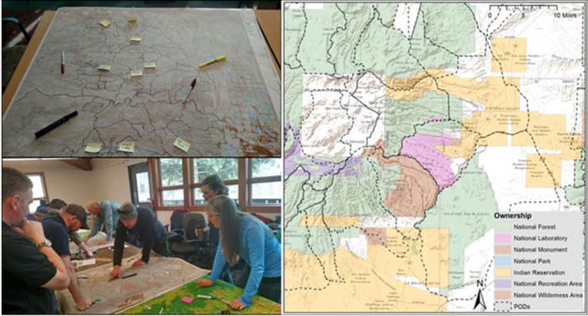
Forests 2020, 11, 909                                                                                2 of 17

Service’s Wildland Fire Risk Management Protocol, which calls for National Forests to “predetermine”
optimal response strategies based on a risk analysis completed with key stakeholders and partner
agencies [13]. Fundamental aims of such pre-season planning are dampening time pressures, reducing
uncertainties, expanding decision space, and clarifying risk–risk tradeoffs associated with incident
response, ultimately to help managers arrive at high-quality response decisions consistent with broader
land and resource management objectives [14–16].
      As the complexity of wildland fire management has increased, so too has the need for risk-based
decision support designed to enhance the safety and effectiveness of large fire management [17–28].
In recent years, the fire science community has developed a wide range of operationally focused
assessment and planning tools. This body of work includes various risk assessment tools to estimate the
social and ecological consequences of fire [29–33]; models of suppression difficulty, resistance to control,
and potential fire control locations that speak to firefighting challenges and opportunities [34–38];
and models of fire responder safety zones, escape routes, and falling tree (snag) hazards to help
suppression resources avoid harm [39–42]. Despite the proliferation of risk-based information, its use
in fire management and decision support remains limited in part due to the lack of attention paid
towards engineering the delivery and communication of this information to key users and decision
makers [43,44].
      Here, we focus on a recently developed spatial fire planning concept called potential wildland fire
operational delineations (PODs). PODs are spatial management and analysis units whose boundaries
are relevant to fire containment operations (e.g., roads, ridgetops, and fuel transitions), within which
potential fire consequences, suppression opportunities/challenges, and strategic response objectives
can be analyzed [45–48]. PODs form a logical basis for designing efficient wildfire response strategies
based on the varying potential to contain fire at barriers that form POD boundaries [49,50]. They are
also relevant analysis units to identify protection priorities across large landscapes [51] and to optimize
fuel treatment placement [52]. As of this writing, PODs have been developed on more than forty
landscapes encompassing National Forest System lands across the western USA, providing utility for
planning, communication, mitigation, prioritization, and incident response at multiple time scales and
levels of decision making [11,48,53–55]. Specific management applications of the PODs concept include
designing and implementing wildfire response strategies, facilitating use of wildfire as a restoration
tool, hardening or creating POD boundaries through timber and vegetation management to enhance
control opportunities, and serving as burn blocks for prescribed fire planning and implementation.
      In this paper we describe the development and application of a new geospatial decision support
tool—a POD Atlas (i.e., a collection of maps and spatial data)—intended to facilitate strategic and
tactical wildfire management decisions. The atlas provides high-resolution information on landscape
conditions, values at risk, and fire management resource needs at the scale of the individual POD. Users
can rapidly access and assimilate multiple forms of pre-loaded data and analytics, in a customizable
manner. We prototyped and operationalized the POD Atlas in concert with, and for use by, local fire
managers on National Forest System lands in the Southern Rocky Mountains of the USA. This work
results from a multi-year, collaborative science-management partnership between National Forest
leadership and staff, Forest Service Research, and the Colorado Forest Restoration Institute, along with
other local and regional stakeholders and partners. Our intent is to broadly expand the user base
throughout the western USA where local managers have developed POD networks and seek additional
analytics and decision support. In the following sections, we provide background information on
wildfire planning and management, detail development and application of the POD Atlas, and highlight
opportunities for continued decision support improvement.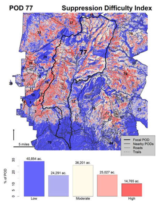
Forests 2020, 11, 909                                                                                  3 of 17

2. Wildfire Planning and Management with PODs

2.1. Background on PODs
       A fundamental aim of the PODs concept is to deliver operationally relevant planning and
decision support, a key need and priority for the fire management research community [21,24,25].
More broadly, goals include supporting safe and effective wildfire response, facilitating co-management
of risk, and facilitating preseason engagement and coordination across boundaries. Like the phrase
“fire knows no boundaries”, opportunities for safe and effective fire control do not necessarily align with
ownership boundaries. Cross-boundary planning can help align expectations for wildfire response
across jurisdictions, coordinate containment efforts at locations with the highest likelihood of success,
and increase transparency of decisions that must balance tradeoffs between responder safety and fire
management objectives. Use of PODs as a cross-boundary planning tool is consistent with the USDA
Forest Service’s Foundational Doctrine for Wildfire Response, which states that the “interdependence
of wildland fire jurisdictions requires the collaborative, proactive engagement of cooperators, partners,
and the public in response activities” [13]. More broadly, use of PODs as a cross-boundary planning
tool is consistent with the “all hands, all lands” emphasis and the risk science underpinning the
National Cohesive Wildland fire Management Strategy in the USA [56].
       In its simplest form, a POD is a spatial container bounded on all sides by pre-identified potential
control locations (PCLs; [10,38,48]). PODs vary in size, typically ranging from hundreds to thousands
of acres, often being smaller near development and larger in remote areas, due in part to factors such
as road density. An iterative process of identifying PCLs, connecting them to form closed polygons
(i.e., PODs), and expanding across the landscape of interest results in a POD network. POD production
has normally occurred in a workshop setting pairing some of the aforementioned decision support
models with local knowledge and expertise (Figure 1, [47]). Two fire analytics models are foundational
to POD identification, which, combined, help managers identify locations on the landscape where
responder safety and probability of control are highest. First is the suppression difficulty index (SDI),
an expert-based system, which is based on fire behavior as a forcing agent and operational factors such
as responder accessibility and mobility as resistance mechanisms [10,34,35]. Second is a predictive
model of PCLs built with a machine learning algorithm that analyzes patterns of historical fire perimeter
locations in relation to topography, fuel transitions, roads, and other landscape features that influence
fire spread [38,48].

      Figure 1. Photos from potential operational delineation (POD) workshops (left), and digitized POD
      network showing cross-boundary overlap (right). Note that PODs are not a kind of ownership but
      rather span ownership boundaries. Bottom left photo shows maps of advanced fire behavior analytics
      provided to support development of PODs.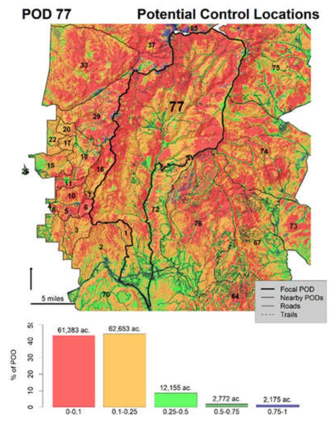
Forests 2020, 11, 909                                                                                4 of 17

     Once POD boundaries have been digitized, a variety of spatial information can be summarized
and mapped to communicate fire management information to a range of audiences (e.g., resource
and communication specialists, incident managers, local fire departments, public officials, and agency
leadership). Vector polygon and attribute data on PODs, along with updated POD boundaries, can also
be uploaded into current wildfire decision support systems [47]. Notably, many National Forests in
the USA have attributed PODs with information from their quantitative risk assessments [29] to guide
the establishment of wildfire response strategies [16,45]. Categorical simplifications of a response
continuum from resource protection to resource benefit can be assigned to PODs to document the
planned response strategy to align the multiple levels of decision making both within and between fire
management organizations [11,55,57]. The process of drawing PODs and assigning response strategies
continues to expand; as of this writing, new landscapes throughout the western USA, including
federal and non-federal partners in California, Colorado, Oregon, and Wyoming, are embarking on the
PODs process.

2.2. Atlas Prototype: Arapaho–Roosevelt National Forest, Colorado, USA
      Feedback from managers indicated that there is rarely local capacity to complete the spatial
analysis, mapping, and data visualization necessary to make PODs useful for decision making,
especially under time constraints. Their desire for assistance on these tasks led us to develop a common
platform, the POD Atlas, capable of attributing PODs with relevant information, mapping a variety
of fire management decision support products, and visualizing POD attributes. We structured the
atlas to be flexible and adaptive to information needs and decision support opportunities across
fire management, seeking to both provide information to develop big picture strategic objectives
and to deliver decision support products with sufficient detail to support tactical and operational
decisions. We initially prototyped a POD Atlas—a map of each POD with a corresponding text
summary—intended to simplify complex information on POD characteristics, ecology, fire behavior,
values at risk, and fire operations into an easily digestible format. The atlas provided a snapshot of
the POD’s location and its boundaries in relation to landscape features, along with what type of fire
behavior to expect, how difficult fire might be to suppress, and what ecological or community values
may be at risk inside the POD. This information was chosen to help initial responders in the field
communicate with key decision makers, some of whom may be working remotely or who may not be
familiar with the physical setting and social context of the fire.
      We developed the prototype with local fire staff on the Arapaho–Roosevelt National Forest in
Colorado, USA (Figure 2). The authors supported POD development efforts on the Forest over the
course of several workshops and have since supported expansion of POD development with other
National Forests in Colorado and neighboring states. By design, the atlas reflected local management
concerns, including watershed health and drinking water importance [58], wildland urban interface
(WUI) protection [59], tree mortality from mountain pine beetles that create operational fire hazards [60],
and modeled suppression difficulty (SDI) based on factors related to accessibility, topography, and fire
behavior [35]. The prototype was built using ESRI ArcGIS and Microsoft Access. Initial manager
feedback was promising. However, the atlas lacked functionality for user customization or streamlined
incorporation of additional geospatial data, which we address in the next section.
      Our intent was to develop a tool to streamline the classification, analysis, and summarization
of diverse spatial data into a common geodatabase, which could then be queried and customized
to display results to a variety of end users. As with the atlas, the foundational summary unit is a
polygon corresponding to a user-defined POD. Desired functionality included a template for input GIS
data (see Table 1, next Section); standardizing national and local data sources (e.g., extent, resolution,
and spatial projection); and performing pre-set and user-specified analyses for each POD in the
geodatabase. With this platform, we can then streamline addressing management-focused questions
such as what percentage of the POD is likely to experience extreme fire behavior, where critical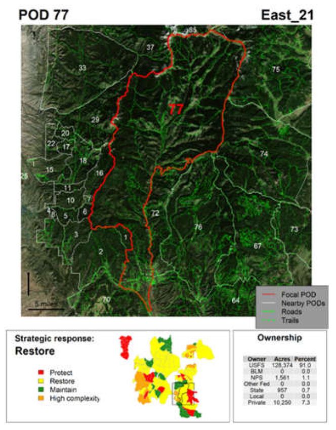
Forests 2020, 11, 909                                                                                                  5 of 17

communications infrastructure is located, the number and area of affected land ownerships, the extent
and density of the wildland–urban interface, etc.

      Figure 2. Prototype developed with local fire staff on the Arapaho–Roosevelt National Forest in
      Colorado, USA. Left panels show location of POD in relation to broader POD network, with different
      underlying reference layers. Right panel shows text-based summary information.

      Table 1. Common data layers extracted and summarized by the POD Summarization Tool. Asterisk
      (*) indicates local data available in some locations where advanced risk modeling analyses have
      been performed.

                                                                                    Strategic
  Basic Statistics         Ecology          Fire Behavior       Values at Risk                          Operations
                                                                                   Objectives
                                              Fire history
                                                                 Population
        Area            Vegetation type   (ignitions and area                      Ownership           Road density
                                                                  density
                                                burned)
                                                                                      Land
     Perimeter             Lifeform        Burn probability     Water supply                           Trail density
                                                                                   designation
                                            Flame length          Net value         Strategic
   Burnable area         Topography                                                                Suppression difficulty
                                             probability          change *       response zone *
                                                                                                     Treatment history
                                                                                                      Potential control
                                                                                                         locations *

2.3. Atlas Development
     Development of the POD Atlas proceeded in two phases (Figure 3), beginning with a Python-based
(Python version 2.7, utilizing the ArcPy module within ESRI ArcGIS) standalone POD Summarization
Tool. Table 1 summarizes some of the common data themes that are extracted from various sources,
reformatted by summary type (e.g., count, mean, and categorical proportion), and summarized for every
POD. The categories of results roughly follow those designed in the initial atlas prototype. Data sources
include land cover, vegetation type, wildland–urban interface, national-scale stochastic fire simulation
results, west-wide suppression difficulty results, fire ignition history, population density, watershed
importance, and treatment and disturbance history commonly used in fire assessments [35,61–67].
Note that the POD Summarization Tool relies on very large, national datasets that are not practical nor
appropriate to share online because of the sensitive nature of some information.
     Additionally, a key feature of the POD Summarization Tool is the functionality to upload local
datasets, notably quantitative risk assessment results, corresponding strategic response zones, and a
PCL probability of control surface. These examples are also included in Table 1. Flexible application of
the tool and constant improvement in data means we do not uniformly impose default datasets, and in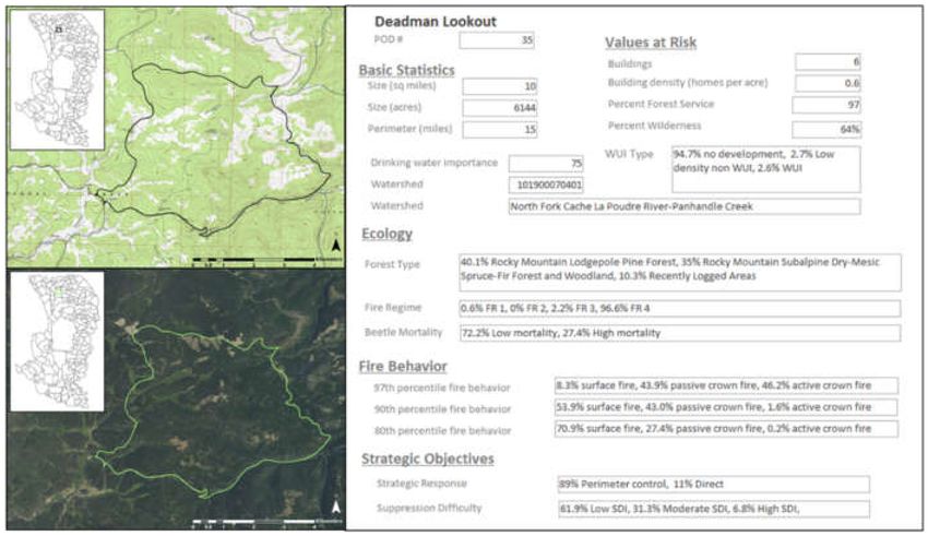
Forests 2020, 11, 909                                                                                           6 of 17

application we extensively document what data sources are used in a guide to accompany summary
and atlas products. Various summary types are available for local datasets, such as sum, total area,
and min/max/mean. Although not presented here, we have also seen managers request summaries of
different information, for example simulated fire behavior across multiple weather scenarios, calibrated
fuel models, other natural hazards (e.g., landslide potential), and habitat. The geodatabase output
from the POD Summarization Tool provides decision support in its own right and provides useful
information for assessment and prioritization purposes. To date, we have provided managers with a
geodatabase compiling all the input data sources used in the assessment be they from national or local
data sources (Figure 3). We do not presently have a mechanism to alter the national data used in the
assessment and doing so may not be wise. Instead, data revisions or substitutions are handled with
the local inputs. For example, if a better data source on population is available locally, the user can
specify the raster data product representing population and select a function to sum the values within
each POD.

      Figure 3. Workflow of POD Summarization and POD Atlas creation. Green parallelograms = input or
      intermediate data (e.g., spatial data and map page); blue rectangles = process; yellow parallelograms =
      final products. Asterisks denote fixed data in the atlas; all other atlas outputs are created with optional
      modules that can be run in parallel to create the desired map or data pages. Stacked symbols indicate
      multiple data sets are processed.

     The second main component of development was the creation of an R-based (R Core Team 2019)
POD Atlas Tool to generate customizable visual displays for each POD. The POD Summarization Tool
provides data inputs to the Atlas Tool. Key processes include overlaying digitized POD boundaries
with aerial imagery, mapping recent wildfire and fuel treatment activity, mapping raster spatial data
such as PCL and SDI, mapping risk assessment results, presenting summary attributes in graphs or
tables, and assembling a PDF book for each POD. The end result is a transition from a single-page text
summary (Figure 2) to a multi-page visual summary (atlas), which can be accessed on a computer or
mobile device, or printed and brought by crews into the field. The POD Atlas has a modular workflow
so the end user can decide what information is relevant for their decision making and what order it
will be displayed in. At present, generating the POD Atlas is performed by a small set of users with
strong GIS and coding skills, and with access to key spatial datasets.

3. Next-Generation Prototype of POD Atlas: Carson and Santa Fe National Forests, New
Mexico, USA
     We worked with local fire managers on the Carson and Santa Fe National Forests to update and
improve the prototype POD Atlas. Leadership and staff from that National Forest, with support from
the authors, performed a quantitative risk assessment and collaboratively developed a POD network
in 2018. PODs, risk assessment results, and strategic response zones (SRZs) facilitated communication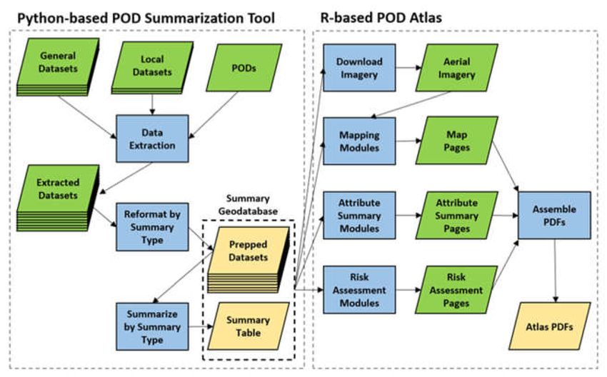
Forests 2020, 11, 909                                                                                         7 of 17

and informed strategic and tactical response decisions on multiple wildfires during the 2019 fire
season [57]. For the purposes of adding functionality to the POD Atlas, local managers indicated that
it would be helpful to map and summarize information from the risk assessment, such as the locations
of highly valued resources and assets (HVRAs) and their response to fire (net value change), to better
understand the negative and positive effects of fire across the landscape. This information could help
them focus protection efforts where fire effects on HVRAs are predicted to be negative. We added this,
and other, map and summary options to the tool (Figure 3; Table 1) and present results here. As of this
writing, the authors are continuing to work with local managers to refine and tailor decision support
in response to their evolving information needs.
     Figure 4 presents results obtained from the POD Summarization Tool, specifically charting the
expected net value change (eNVC) risk assessment results (y-axis), total area rated as low PCL (x-axis),
and total area rated as high SDI (bubble size), for each POD. Collectively these risk metrics can
indicate problematic PODs where expected loss is high and control opportunities are restricted, which
can be useful for strategic prioritization and mitigation. Three PODs are highlighted (PODs 31, 38,
and 77), reflecting a spectrum of conditions. Specifically, POD 31 has a positive expected net value
change—reflecting potential for ecosystem benefits from fire—along with low concerns over PCL and
SDI, suggesting opportunities for management strategies other than full suppression. PODs 38 and
77, by contrast, have potential for significant loss (negative eNVC values). POD 77 in particular is
problematic due to large areas of low PCL and high SDI. Note that we could have also compared PCL
and SDI for PODs on the basis of proportional area, but chose total area to reflect that POD size and
associated fire size potential are also drivers of suppression demand. We describe these PODs in more
detail with corresponding atlas examples below, beginning with operational concerns.

      Figure 4. Bubble chart comparing the sum of expected net value change (eNVC; y-axis) to total area
      rated as low probability of suitable potential control location (PCL; x-axis) to total area rated as high
      in the suppression difficulty index (SDI; bubble size). Three PODs are highlighted to reflect a range
      of conditions.

     Figure 5 presents the standardized cover page of the PDF book for POD 77, which displays the
focal POD in relation to aerial imagery, road layers, adjacent PODs, and SRZ categories. Percentage
land ownership within the POD is also summarized, which can be an important determinant of
cross-jurisdictional management and incident complexity. Next, Figure 6 shows additional information
on the landscape context for POD 77; in this case, displaying information on fire behavior (burn and
flame length probability), operations (road density), and values at risk (population density and
watersheds supplying drinking water). Users can specify which information to be displayed based
on available layers from the POD Summarization Tool (Figure 3). The atlas provides histograms and
cumulative distribution lines that contextualize the focal POD in relation to all PODs, also providing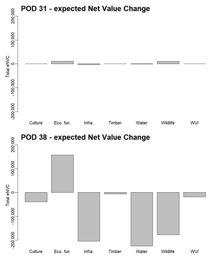
Forests 2020, 11, 909                                                                                   8 of 17

percentile indicators. In this specific case, POD 77 has relatively higher potential for fire activity,
relatively low road density indicating low accessibility and control opportunity, and relatively high
concerns for values at risk.

      Figure 5. First page of POD Atlas showing focal POD boundaries in relation to aerial imagery, road
      layers, adjacent PODs, and strategic response categories, and describing land ownership in the POD.

      Figure 6. Graphical attribute summary for POD 77, showing the focal POD in relation to histograms,
      cumulative distributions, and percentiles across all PODs, for Landscan-based population, drinking
      water importance (F2F = Forests to Faucets), simulated flame lengths, road density, and simulated
      burn probability.

     POD 77 also has the greatest area rated as low suitability for potential control locations and the
highest area rated as high suppression difficulty, further highlighting operational challenges. Figures 7
and 8 map PCL and SDI model results, respectively, for POD 77 and its surrounding landscape to guide
decisions of where to send responders so they can safely and effectively engage fire (Stratton 2020). For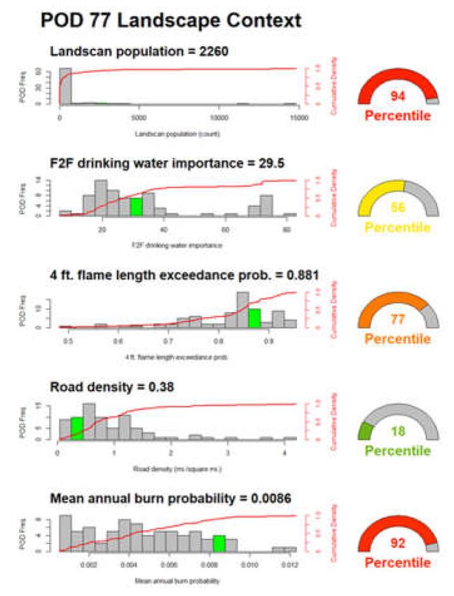
Forests 2020, 11, 909                                                                                      9 of 17

this analysis (and that presented above in Figure 4) we defined low PCL suitability as an area with 25%
or lower probability of fire containment. Roads and trails are mapped to communicate complementary
information on responder accessibility and mobility. For example, the high road density in the southern
portion of the POD results in relatively high PCL and low SDI. In other locations, control opportunities
seem more severely restricted. Part of the reason POD 77 stands out is simply due to size—it has the
largest perimeter and third largest area of all PODs, but as POD size is dictated by operational concerns
such as the presence of suitable control locations, size is by definition an operational factor. Further,
POD 77 ranks 17th (of 77) for percent area of low PCL suitability, and 14th for percent area of high SDI.

      Figure 7. Model-based potential control location (PCL) probability surface for POD 77, with histogram
      displaying total and percent area in each of five quantitative PCL suitability classes.

      Figure 8. Model-based suppression difficulty index (SDI) surface for POD 77, with histogram displaying
      total and percent area in each of three categorical SDI classes.
Forests 2020, 11, 909 10 of 17
The POD Atlas can also summarize key information on land and resource risks. Figure 9 presents
risk assessment profiles for PODs 31 and 38, which have contrasting levels of risk. Risk assessment
results are broken down according to seven categories of HVRAs: cultural resources, ecosystem
function, infrastructure, timber resources, water, wildlife, and wildland–urban interface. The total
eNVC value for POD 31 is a net positive, indicating that the appropriate strategic response may be to
maintain the natural (beneficial) role of fire. The POD also presents limited operational challenges
(Figure 4), indicating potential to effectively manage natural fire within pre-defined POD boundaries,
as has been done elsewhere (see [11]). The absolute magnitudes of eNVC values are far greater for
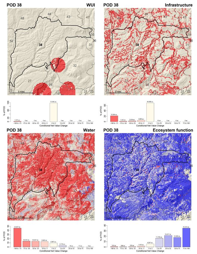
POD 38, with overall expected net losses due to fire. Figure 10 displays spatially explicit estimates of
conditional Net Value Change (cNVC) from the quantitative risk assessment for a subset of HVRAs
in POD 38. In contrast to eNVC, cNVC excludes the likelihood of experiencing fire and focuses on
the interaction of value susceptibility and fire intensity [29,30]. The ecosystem function HVRA is
widely distributed and mostly expected to benefit from fire, but it overlaps in some places with HVRAs
expected to be negatively impacted by fire (e.g., municipal water supply), indicating the complexity of
fire management balancing multiple objectives.
Figure 9. Risk assessment profiles for POD 31 (top) and POD 38 (bottom), breaking down total expected
net value change (eNVC; Figure 4) into individual eNVC scores for seven categories of highly valued
resources and assets (cultural resources, ecosystem function, infrastructure, timber resources, water,
wildlife, and wildland–urban interface).
A range of other summarizations and visualizations are possible, for instance the POD Atlas
can map recent fire activity to identify areas where falling trees may present a hazard, or recent
fuel treatments to identify areas where control opportunities may be enhanced. Similarly, a range
of intra-POD comparisons could be explored beyond what was presented in Figure 4. Further, the
POD Atlas can facilitate strategic response assignments by streamlining the process of overlaying risk
assessment results with potential control locations and other information. Our primary aim here is
to illustrate the potential of the POD Summarization and Atlas Tools, contextualized on a real-world
landscape where local managers have found great utility in PODs and provided feedback to support
tool development.Forests 2020, 11, 909 11 of 17
Figure 10. Spatial risk assessment results for POD 38, for a select set of HVRAs: wildland–urban
interface (top left); infrastructure (top right); water (bottom left); and ecosystem function (bottom right).
4. Discussion
The POD Summarization and Atlas Tools join an emerging portfolio of strategic fire planning
tools being operationalized on National Forest System and adjacent lands throughout the western
USA, including maps depicting suppression difficulty, potential control locations, and quantitativeForests 2020, 11, 909 12 of 17
risk assessment results [48]. PODs can inform fire management decisions, facilitate communication
and outreach, support prescribed fire planning and implementation along with use of natural fire
as a restoration tool, help identify problem areas and prioritize risk mitigation, and help identify
areas where hardening POD boundaries through timber and vegetation management could enhance
control opportunities. Key decision makers, on-the-ground fire staff, local emergency response
agencies, non-governmental organizations, and stakeholders, among others, have participated in POD
workshops and the process of collaboratively developing PODs with a diverse group of stakeholders is
facilitating co-management of cross-boundary wildfire risk [54].
Early and iterative engagement with managers has helped us craft tools that have been
operationalized for real-world use, and iteratively improved over time. The POD Atlas can streamline
the process of summarizing risks, suppression opportunities/challenges, and strategic response
objectives, supporting decisions ranging from long-term implementation plans to boots-on-the-ground
initial response to a newly detected ignition. The connected workflows of the POD Summarization
and Atlas Tools help to assimilate a range of information that users can query to aid comparative POD
assessment and prioritization exercises, and translate this information into fire management resource
needs in a flexible and customizable manner. Ultimately, our aim is to provide actionable decision
support that informs development of safe and effective response strategies and tactics, and secondly to
help infuse analytics into planning and operations more widely [16,47].
The flexible and modular approach of the POD Summarization and Atlas Tools can be
complementary to existing wildfire decision support providing standardized fire modeling, risk analysis,
and decision documentation tools for incident management [43,44,68,69]. Low-cost investment in
scripting to automate analysis, mapping, and data visualization workflows in Python and R provides a
means primarily to expand access to information that local units deem useful for their fire management
decision needs. This style of decision support tool provides great flexibility to customize information
delivery and with minimal end user requirements. We originally pursued a web-based platform
designed to assimilate rapidly changing information but instead chose a PDF booklet for the initial
rollout of the POD Atlas because mobile internet access is often poor in the wildlands that fire and
land managers operate in. The PDF format facilitates data storage and access on low-performance
mobile computing devices such as phones and tablets.
Another key strength of the POD-based approach is the explicit and targeted inclusion of local
managers, experts, and stakeholders. A fundamental idea here is that the POD Atlas provides regional
and national data for a baseline degree of standardization, augmented by locally relevant data that
may be more specialized, accurate, recent, or field validated and trusted. Local feedback and input
enters into the process via several pathways: (1) contribution of local data, knowledge, and values to
develop risk assessment products; (2) interpretation of national or local products to delineate the PODs
and assign them strategic responses; and (3) selection of data to visualize in the atlas products. There
is also opportunity for managers to critique and revise the local application of SDI and PCL models
by contributing locally accurate data. Additionally, both these analytical products have continuous
values, so it is straightforward for managers to adjust visualization and summary metrics to align with
their desired interpretation.
Based on the current implementation of these tools in management, we envision that POD
Summarization and Atlas products will be updated on an annual or biannual basis to best reflect
current landscape conditions. Any modeled fire behavior or effects delivered in the POD Summarization
and Atlas products are based on either expected or user-specified fire weather conditions, which may
not match the conditions of a specific fire incident, but this can be mitigated by modeling fire behavior
under a wider range of fire weather scenarios. It is important to acknowledge this limitation, but much
of the information being requested by managers so far focuses on the spatial extent of fire-sensitive
resources and assets, whether their responses are mostly negative or positive, and suppression
effectiveness and safety indices that are not highly sensitive to variation in fire behavior.Forests 2020, 11, 909 13 of 17
There are limitations to acknowledge with these tools and PODs in general. First, the utility of
PODs is largely dependent on the process of creating them, including questions of who participated in
workshops, the breadth of expertise captured, the range of stakeholder concerns addressed, and the
degree of trust and support for moving forward with cross-boundary planning. Including a broad
range of participants can be desirable to establish a common understanding of management challenges,
opportunities, values and concerns, but it can also introduce potential for conflict. One proposed
solution to diffuse contention and foster inclusive participation is use of third-party facilitators [54].
Second, the precursors to use of the tool—notably facilitation of POD workshops, geospatial
analysis of PCL and SDI, and fire behavior simulation—can be time and resource intensive and those
skills may not be available in all places. As one example, although we have recognized the value
of documenting PCL attributes including feature type (e.g., road, trail, and stream), width, slope
position, and accessibility, we have yet to develop a consistent process to collect and communicate
this information. Our experience has been that it is very labor intensive to collect this information at
high resolution when digitizing the PODs. In our initial efforts, managers primarily identified and
mapped PCLs at coarse resolutions on paper maps, which were later digitized into PCLs and then
converted to PODs. One issue is that the GIS staff may not have the local expertise to properly assign
attributes when digitizing the PCLs. Additionally, there are questions about the appropriate scale for
these data and whether PCLs should be split at each transition between feature types or conditions,
or aggregated over some larger distance (say the unique edge between PODs) and attributed with the
majority attributes.
Third, reliance on fire behavior models means introduction of model error and uncertainty,
hence the emphasis on also relying on local expert knowledge. Capturing expert judgment requires
preparation, especially in terms of defining an elicitation protocol [70]. In practice, we often aim to
stimulated deliberative thought with a pilot round asking experts to identify control locations and
containment polygons for various ignition scenarios, and then expand to the landscape scale through
discussion, feedback, and iteration. Improving processes and ensuring rigor in elicitation of expert
judgment remain an important research direction [31,71].
Fourth, as a POD map is intended to be a living document that is updated in response to changing
landscape conditions, there are workload requirements for updating geospatial data and analyses
over time. As stated above, we anticipate that these products will be updated on a biennial basis to
align with fuel data revisions from LANDFIRE [61] and the need to revise products based on recent
fuel modifications from wildfires, forest management, and other disturbances. Although this timeline
means products may be temporarily out of date for parts of the landscape, managers are generally
aware of recent activities and their likely impacts on fire behavior and effects.
5. Conclusions
In summary, we reviewed spatial wildfire management and planning using the POD framework,
briefly discussed emerging analytics used to support wildfire decisions, and introduced new
complementary geospatial decision support tools. The POD Atlas workflow extracts, reformats,
and assimilates a wide range of operationally relevant information on PODs including basic statistics,
ecology, fire behavior, values at risk, strategic objectives, and operations, and then streamlines
the process of summarizing and displaying a range of user-specified geospatial data and model
results. These decision support tools were designed with flexibility in mind to meet the diverse
information needs of fire managers on National Forest System and surrounding lands in the
western USA where POD-based planning and management is common. Ideally, the POD Atlas
complements and adds value to existing assessment and planning efforts, specifically helping to
operationalize risk assessments and to make spatial data more useful for land and fire management
planning. Collaboration with managers was critical for our initial prototyping and we expect that
their continued feedback will improve the form and content of future updates to these POD-based
decision support tools. Future uses and refinements of the tools will ideally support risk-informedForests 2020, 11, 909 14 of 17
and science-based decision making in the context of wildfire management. Interested practitioners
wanting to learn more about implementing these tools can find more details and contact information
here (https://www.fs.usda.gov/rmrs/groups/wildfire-risk-management-science-team).
Author Contributions: Conceptualization, M.P.T., B.M.G., M.D.C., and C.D.O.; methodology, B.M.G., M.D.C.,
C.D.O., A.B., J.W.G.-D., and J.H.S.; software, B.M.G., A.B., J.W.G.-D., and J.H.S.; writing—original draft preparation,
M.P.T.; writing—review and editing, M.P.T., B.M.G., M.D.C., and C.D.O.; project administration, M.P.T. and C.D.O.
All authors have read and agreed to the published version of the manuscript.
Funding: This research was funded in part by joint venture agreement number 18-JV-11221636-099 between
Colorado State University and the USDA Forest Service Rocky Mountain Research Station.
Acknowledgments: This research was supported by the U.S. Department of Agriculture, Forest Service. We thank
the many participants in fire planning workshops, especially National Forest staff and Rich Sack in particular.
Conflicts of Interest: The authors declare no conflict of interest. The findings and conclusions in this paper
are those of the author(s) and should not be construed to represent any official USDA or U.S. Government
determination or policy.
References
1. Williams, A.P.; Abatzoglou, J.T. Recent advances and remaining uncertainties in resolving past and future
climate effects on global fire activity. Curr. Clim. Chang. Rep. 2016, 2, 1–14. [CrossRef]
2. Holden, Z.A.; Swanson, A.; Luce, C.H.; Jolly, W.M.; Maneta, M.; Oyler, J.W.; Warren, D.A.; Parsons, R.;
Affleck, D. Decreasing fire season precipitation increased recent western US forest wildfire activity. Proc. Natl.
Acad. Sci. USA 2018, 115, E8349–E8357. [CrossRef] [PubMed]
3. Jolly, W.M.; Cochrane, M.A.; Freeborn, P.H.; Holden, Z.A.; Brown, T.J.; Williamson, G.J.; Bowman, D.M.
Climate-induced variations in global wildfire danger from 1979 to 2013. Nat. Commun. 2015, 6, 1–11.
[CrossRef] [PubMed]
4. Kramer, H.A.; Mockrin, M.H.; Alexandre, P.M.; Stewart, S.I.; Radeloff, V.C. Where wildfires destroy buildings
in the US relative to the wildland–urban interface and national fire outreach programs. Int. J. Wildland Fire
2018, 27, 329–341. [CrossRef]
5. Radeloff, V.C.; Helmers, D.P.; Kramer, H.A.; Mockrin, M.H.; Alexandre, P.M.; Bar-Massada, A.; Butsic, V.;
Hawbaker, T.J.; Martinuzzi, S.; Syphard, A.D.; et al. Rapid growth of the US wildland-urban interface raises
wildfire risk. Proc. Natl. Acad. Sci. USA 2018, 115, 3314–3319. [CrossRef] [PubMed]
6. Page, W.G.; Freeborn, P.H.; Butler, B.W.; Jolly, W.M. A review of US wildland firefighter entrapments: Trends,
important environmental factors and research needs. Int. J. Wildland Fire 2019, 28, 551–569. [CrossRef]
7. Parks, S.A.; Holsinger, L.M.; Panunto, M.H.; Jolly, W.M.; Dobrowski, S.Z.; Dillon, G.K. High-severity fire:
Evaluating its key drivers and mapping its probability across western US forests. Environ. Res. Lett. 2018, 13,
044037. [CrossRef]
8. Stephens, S.L.; Collins, B.M.; Fettig, C.J.; Finney, M.A.; Hoffman, C.M.; Knapp, E.E.; North, M.P.; Safford, H.;
Wayman, R.B. Drought, tree mortality, and wildfire in forests adapted to frequent fire. BioScience 2018, 68,
77–88. [CrossRef]
9. Tedim, F.; Leone, V.; Amraoui, M.; Bouillon, C.; Coughlan, M.R.; Delogu, G.M.; Fernandes, P.M.; Ferreira, C.;
McCaffrey, S.; McGee, T.K.; et al. Defining extreme wildfire events: Difficulties, challenges, and impacts. Fire
2018, 1, 9. [CrossRef]
10. O’Connor, C.D.; Thompson, M.P.; Rodríguez y Silva, F. Getting ahead of the wildfire problem: Quantifying
and mapping management challenges and opportunities. Geosciences 2016, 6, 35. [CrossRef]
11. O’Connor, C.D.; Calkin, D.E. Engaging the fire before it starts: A case study from the 2017 Pinal Fire (Arizona).
Wildfire 2019, 28, 14–18.
12. Schultz, C.A.; Moseley, C. Collaborations and capacities to transform fire management. Science 2019, 366,
38–40. [CrossRef] [PubMed]
13. National Interagency Fire Center (NIFC) Interagency Standards for Fire and Fire Aviation Operations 2020,
Chapter 5. Available online: https://www.nifc.gov/PUBLICATIONS/redbook/2020/Chapter05.pdf (accessed
on 8 August 2020).
14. Meyer, M.D.; Roberts, S.L.; Wills, R.; Brooks, M.; Winford, E.M. Principles of effective USA federal fire
management plans. Fire Ecol. 2015, 11, 59–83. [CrossRef]Forests 2020, 11, 909 15 of 17
15. Thompson, M.P.; MacGregor, D.G.; Calkin, D. Risk Management: Core Principles and Practices, and Their
Relevance to Wildland Fire; General Technical Report RMRS-GTR-350; U.S. Department of Agriculture, Forest
Service, Rocky Mountain Research Station: Fort Collins, CO, USA, 2016; p. 29.
16. Thompson, M.P.; MacGregor, D.G.; Dunn, C.J.; Calkin, D.E.; Phipps, J. Rethinking the wildland fire
management system. J. For. 2018, 116, 382–390. [CrossRef]
17. Duff, T.J.; Tolhurst, K.G. Operational wildfire suppression modelling: A review evaluating development,
state of the art and future directions. Int. J. Wildland Fire 2015, 24, 735–748. [CrossRef]
18. Martell, D.L. A review of recent forest and wildland fire management decision support systems research.
Curr. For. Rep. 2015, 1, 128–137. [CrossRef]
19. Kalabokidis, K.; Ager, A.; Finney, M.; Athanasis, N.; Palaiologou, P.; Vasilakos, C. AEGIS: A wildfire
prevention and management information system. Nat. Hazards Earth Syst. Sci. 2016, 16, 643–661. [CrossRef]
20. Penman, T.D.; Cirulis, B.; Marcot, B.G. Bayesian decision network modeling for environmental risk
management: A wildfire case study. J. Environ. Manag. 2020, 270, 110735. [CrossRef]
21. Thompson, M.P.; Rodríguez y Silva, F.; Calkin, D.E.; Hand, M.S. A review of challenges to determining and
demonstrating efficiency of large fire management. Int. J. Wildland Fire 2017, 26, 562–573. [CrossRef]
22. Johnston, L.M.; Wang, X.; Erni, S.; Taylor, S.W.; McFayden, C.B.; Oliver, J.A.; Stockdale, C.; Christianson, A.;
Boulanger, Y.; Gauthier, S.; et al. Wildland fire risk research in Canada. Environ. Rev. 2020, 28, 164–186.
[CrossRef]
23. Monedero, S.; Ramirez, J.; Cardil, A. Predicting fire spread and behaviour on the fireline. Wildfire analyst
pocket: A mobile app for wildland fire prediction. Ecol. Model. 2019, 392, 103–107. [CrossRef]
24. Plucinski, M.P. Fighting flames and forging firelines: Wildfire suppression effectiveness at the fire edge.
Curr. For. Rep. 2019, 5, 1–19. [CrossRef]
25. Plucinski, M.P. Contain and control: Wildfire suppression effectiveness at incidents and across landscapes.
Curr. For. Rep. 2019, 5, 20–40. [CrossRef]
26. Gonzalez-Olabarria, J.R.; Reynolds, K.M.; Larrañaga, A.; Garcia-Gonzalo, J.; Busquets, E.; Pique, M. Strategic
and tactical planning to improve suppression efforts against large forest fires in the Catalonia region of Spain.
For. Ecol. Manag. 2019, 432, 612–622. [CrossRef]
27. Castellnou, M.; Prat-Guitart, N.; Arilla, E.; Larrañaga, A.; Nebot, E.; Castellarnau, X.; Vendrell, J.; Pallàs, J.;
Herrera, J.; Monturiol, M.; et al. Empowering strategic decision-making for wildfire management: Avoiding
the fear trap and creating a resilient landscape. Fire Ecol. 2019, 15, 31. [CrossRef]
28. Pacheco, A.P.; Claro, J.; Fernandes, P.M.; de Neufville, R.; Oliveira, T.M.; Borges, J.G.; Rodrigues, J.C. Cohesive
fire management within an uncertain environment: A review of risk handling and decision support systems.
For. Ecol. Manag. 2015, 347, 1–17. [CrossRef]
29. Scott, J.H.; Thompson, M.P.; Calkin, D.E. A Wildfire Risk Assessment Framework for Land and Resource Management;
General Technical Report RMRS-GTR-315; U.S. Department of Agriculture, Forest Service, Rocky Mountain
Research Station: Fort Collins, CO, USA; p. 83. [CrossRef]
30. Thompson, M.P.; Haas, J.R.; Gilbertson-Day, J.W.; Scott, J.H.; Langowski, P.; Bowne, E.; Calkin, D.E.
Development and application of a geospatial wildfire exposure and risk calculation tool. Environ. Model.
Softw. 2015, 63, 61–72. [CrossRef]
31. McFayden, C.B.; Boychuk, D.; Woolford, D.G.; Wheatley, M.J.; Johnston, L. Impacts of wildland fire effects on
resources and assets through expert elicitation to support fire response decisions. Int. J. Wildland Fire 2019,
28, 885–900. [CrossRef]
32. Jolly, W.M.; Freeborn, P.H.; Page, W.G.; Butler, B.W. Severe fire danger index: A forecastable metric to inform
firefighter and community wildfire risk management. Fire 2019, 2, 47. [CrossRef]
33. Ramirez, J.; Monedero, S.; Silva, C.A.; Cardil, A. Stochastic decision trigger modelling to assess the probability
of wildland fire impact. Sci. Total Environ. 2019, 694, 133505. [CrossRef]
34. Rodríguez y Silva, F.R.; Martínez, J.R.M.; González-Cabán, A. A methodology for determining operational
priorities for prevention and suppression of wildland fires. Int. J. Wildland Fire 2014, 23, 544–554. [CrossRef]
35. Rodríguez y Silva, F.R.; O’Connor, C.D.; Thompson, M.P.; Martínez, J.R.M.; Calkin, D.E. Modelling
suppression difficulty: Current and future applications. Int. J. Wildland Fire 2020, 29, 739–751. [CrossRef]
36. Rodrigues, M.; Alcasena, F.; Gelabert, P.; Vega-García, C. Geospatial modeling of containment probability for
escaped wildfires in a Mediterranean region. Risk Anal. 2020. Available online: https://onlinelibrary.wiley.
com/doi/full/10.1111/risa.13524 (accessed on 18 August 2020). [CrossRef] [PubMed]Forests 2020, 11, 909 16 of 17
37. Mitsopoulos, I.; Mallinis, G.; Zibtsev, S.; Yavuz, M.; Saglam, B.; Kucuk, O.; Bogomolov, V.; Borsuk, A.;
Zaimes, G. An integrated approach for mapping fire suppression difficulty in three different ecosystems of
Eastern Europe. J. Spat. Sci. 2017, 62, 139–155. [CrossRef]
38. O’Connor, C.D.; Calkin, D.E.; Thompson, M.P. An empirical machine learning method for predicting potential
fire control locations for pre-fire planning and operational fire management. Int. J. Wildland Fire 2017, 26,
587–597. [CrossRef]
39. Campbell, M.J.; Dennison, P.E.; Butler, B.W. Safe separation distance score: A new metric for evaluating
wildland firefighter safety zones using lidar. Int. J. Geogr. Inf. Sci. 2017, 31, 1448–1466. [CrossRef]
40. Campbell, M.J.; Dennison, P.E.; Butler, B.W. A LiDAR-based analysis of the effects of slope, vegetation density,
and ground surface roughness on travel rates for wildland firefighter escape route mapping. Int. J. Wildland
Fire 2017, 26, 884–895. [CrossRef]
41. Campbell, M.J.; Page, W.G.; Dennison, P.E.; Butler, B.W. Escape route index: A spatially-explicit measure of
wildland firefighter egress capacity. Fire 2019, 2, 40. [CrossRef]
42. Dunn, C.J.; O’Connor, C.D.; Reilly, M.J.; Calkin, D.E.; Thompson, M.P. Spatial and temporal assessment
of responder exposure to snag hazards in post-fire environments. For. Ecol. Manag. 2019, 441, 202–214.
[CrossRef]
43. Rapp, C.; Rabung, E.; Wilson, R.; Toman, E. Wildfire decision support tools: An exploratory study of use in
the United States. Int. J. Wildland Fire 2020, 29, 581–594. [CrossRef]
44. Noble, P.; Paveglio, T.B. Exploring adoption of the wildland fire decision support system: End user
perspectives. J. For. 2020, 118, 154–171. [CrossRef]
45. Thompson, M.P.; Bowden, P.; Brough, A.; Scott, J.H.; Gilbertson-Day, J.; Taylor, A.; Anderson, J.; Haas, J.R.
Application of wildfire risk assessment results to wildfire response planning in the southern Sierra Nevada,
California, USA. Forests 2016, 7, 64. [CrossRef]
46. Dunn, C.J.; Thompson, M.P.; Calkin, D.E. A framework for developing safe and effective large-fire response
in a new fire management paradigm. For. Ecol. Manag. 2017, 404, 184–196. [CrossRef]
47. Thompson, M.P.; Wei, Y.; Calkin, D.E.; O’Connor, C.D.; Dunn, C.J.; Anderson, N.M.; Hogland, J.S. Risk
management and analytics in wildfire response. Curr. For. Rep. 2019, 5, 226–239. [CrossRef]
48. Dunn, C.J.; DO’Connor, C.; Abrams, J.; Thompson, M.P.; Calkin, D.E.; Johnston, J.D.; Stratton, R.;
Gilbertson-Day, J. Wildfire risk science facilitates adaptation of fire-prone social-ecological systems to
the new fire reality. Environ. Res. Lett. 2020, 15, 025001. [CrossRef]
49. Wei, Y.; Thompson, M.P.; Haas, J.R.; Dillon, G.K.; O’Connor, C.D. Spatial optimization of operationally
relevant large fire confine and point protection strategies: Model development and test cases. Can. J. For.
Res. 2018, 48, 480–493. [CrossRef]
50. Wei, Y.; Thompson, M.P.; Scott, J.H.; O’Connor, C.D.; Dunn, C.J. Designing operationally relevant daily large
fire containment strategies using risk assessment results. Forests 2019, 10, 311. [CrossRef]
51. Thompson, M.P.; Liu, Z.; Wei, Y.; Caggiano, M.D. Analyzing Wildfire Suppression Difficulty in Relation to
Protection Demand. Environmental Risks’; Mihai, F.L., Ed.; IntechOpen: London, UK, 2018; pp. 45–64.
52. Thompson, M.P.; Riley, K.L.; Loeffler, D.; Haas, J.R. Modeling fuel treatment leverage: Encounter rates, risk
reduction, and suppression cost impacts. Forests 2017, 8, 469. [CrossRef]
53. Caggiano, M. Collaboratively Engaging Stakeholders to Develop Potential Operational Delineations; CFRI-1908;
Colorado Forest Restoration Institute: Fort Collins, CO, USA, 2019.
54. Greiner, M.; Kooistra, C.; Schultz, C. Pre-Season Planning for Wildland Fire Response: An Assessment of the
US Forest Service’s Potential Operational Delineations (PODs); Public Lands Policy Group at Colorado State
University: Fort Collins, CO, USA, 2020.
55. Stratton, R.D. The path to strategic wildland fire management planning. Wildfire 2020, 29, 24–31.
56. Calkin, D.E.; Ager, A.A.; Thompson, M.P. A Comparative Risk Assessment Framework for Wildland Fire
Management: The 2010 Cohesive Strategy Science Report; General Technical Report RMRS-GTR-262; Finney, M.A.,
Lee, D.C., Quigley, T.M., McHugh, C.W., Riley, K.L., Gilbertson-Day, J.M., Eds.; U.S. Department of Agriculture,
Forest Service, Rocky Mountain Research Station: Fort Collins, CO, USA, 2011; p. 63.
57. Caggiano, M.D.; O’Connor, C.D.; Sack, R.B. Potential Operational Delineations and Northern New Mexico’s 2019
Fire Season; Colorado Forest Restoration Institute: Fort Collins, CO, USA, 2020.Forests 2020, 11, 909 17 of 17
58. Gannon, B.M.; Wei, Y.; MacDonald, L.H.; Kampf, S.K.; Jones, K.W.; Cannon, J.B.; Wolk, B.H.; Cheng, A.S.;
Addington, R.N.; Thompson, M.P. Prioritising fuels reduction for water supply protection. Int. J. Wildland
Fire 2019, 28, 785–803. [CrossRef]
59. Caggiano, M.D.; Tinkham, W.T.; Hoffman, C.; Cheng, A.S.; Hawbaker, T.J. High resolution mapping of
development in the wildland-urban interface using object based image extraction. Heliyon 2016, 2, e00174.
[CrossRef] [PubMed]
60. Moriarty, K.; Cheng, A.S.; Hoffman, C.M.; Cottrell, S.P.; Alexander, M.E. Firefighter observations of
“surprising” fire behavior in mountain pine beetle-attacked lodgepole pine forests. Fire 2019, 2, 34. [CrossRef]
61. Rollins, M.G. LANDFIRE: A nationally consistent vegetation, wildland fire, and fuel assessment. Int. J.
Wildland Fire 2009, 18, 235–249. [CrossRef]
62. Short, K.C. Spatial Wildfire Occurrence Data for the United States, 1992–2015; FPA_FOD_20170508; USDA:
Washington, DC, USA, 2017.
63. Finney, M.A.; McHugh, C.W.; Grenfell, I.C.; Riley, K.L.; Short, K.C. A simulation of probabilistic wildfire risk
components for the continental United States. Stoch. Environ. Res. Risk Assess. 2011, 25, 973–1000. [CrossRef]
64. Interagency Fuel Treatment Decision Support System. Fuel Treatment Data Sources Used by FTEM
(An Overview). 2020. Available online: https://iftdss.firenet.gov/firenetHelp/help/pageHelp/content/10-ftem/
datatechnical/treatments.htm (accessed on 18 August 2020).
65. Scott, J.H.; Thompson, M.P.; Gilbertson-Day, J.W. Exploring how alternative mapping approaches influence
fireshed assessment and human community exposure to wildfire. GeoJournal 2017, 82, 201–215. [CrossRef]
66. Haas, J.R.; Calkin, D.E.; Thompson, M.P. A national approach for integrating wildfire simulation modeling
into Wildland Urban Interface risk assessments within the United States. Landsc. Urban Plan. 2013, 119,
44–53. [CrossRef]
67. Thompson, M.P.; Scott, J.; Langowski, P.G.; Gilbertson-Day, J.W.; Haas, J.R.; Bowne, E.M. Assessing
watershed-wildfire risks on national forest system lands in the rocky mountain region of the United States.
Water 2013, 5, 945–971. [CrossRef]
68. Calkin, D.E.; Thompson, M.P.; Finney, M.A.; Hyde, K.D. A real-time risk assessment tool supporting wildland
fire decisionmaking. J. For. 2011, 109, 274–280.
69. Noonan-Wright, E.K.; Opperman, T.S.; Finney, M.A.; Zimmerman, G.T.; Seli, R.C.; Elenz, L.M.; Calkin, D.E.;
Fiedler, J.R. Developing the US wildland fire decision support system. J. Combust. 2011, 2011, 168473.
[CrossRef]
70. Drescher, M.; Perera, A.H.; Johnson, C.J.; Buse, L.J.; Drew, C.A.; Burgman, M.A. Toward rigorous use of
expert knowledge in ecological research. Ecosphere 2013, 4, 1–26. [CrossRef]
71. Morgan, M.G. Use (and abuse) of expert elicitation in support of decision making for public policy. Proc. Natl.
Acad. Sci. USA 2014, 111, 7176–7184. [CrossRef] [PubMed]
© 2020 by the authors. Licensee MDPI, Basel, Switzerland. This article is an open access
article distributed under the terms and conditions of the Creative Commons Attribution
(CC BY) license (http://creativecommons.org/licenses/by/4.0/).You can also read