D4.1.1 Report on the characterization of the selected Natura 2000 sites
←
→
Page content transcription
If your browser does not render page correctly, please read the page content below
ECOlogical observing System in the Adriatic Sea: oceanographic observations for biodiversity

                     Priority Axis 3: Environment and cultural heritage

           Specific Objective 3.2: Contribute to protect and restore biodiversity

       D4.1.1 Report on the
  characterization of the selected
         Natura 2000 sites
     WP4 – Establishing the Ecological Observing System in the Adriatic Sea (ECOAdS)
                A4.1.– Characterization of the Natura 2000 study sites

                          PP7 Sea and Karst / Martina Markov
                    Other involved partners: LP, PP1, PP4, PP5, PP6
                                           Final
                                          Public
                                      27th June 2019
CONTENT

1. INTRODUCTION .................................................................................................................................. 4
2. CHARACTERIZATION OF THE SELECTED NATURA2000 SITES ............................................................. 7
   2.1. HR3000469 Viški akvatorij .......................................................................................................... 7
       2.1.1. Information about the site ................................................................................................... 7
       2.1.2. Information about the target species ................................................................................ 11
       2.1.3. Other important species .................................................................................................... 12
       2.1.4. SWOT analysis .................................................................................................................... 12
   2.2. HR3000161 Cres-Lošinj .............................................................................................................. 13
       2.2.1. Information about the site ................................................................................................. 13
       2.2.2. Information about the target species ................................................................................ 16
       2.2.3. Other important species .................................................................................................... 17
       2.2.4. SWOT analysis .................................................................................................................... 17
   2.3. HR4000015 Malostonski zaljev ................................................................................................. 18
       2.3.1. Information about the site ................................................................................................. 18
       2.3.2. Habitat types on the site .................................................................................................... 22
       2.3.3. Other important species .................................................................................................... 22
       2.3.4. SWOT analysis .................................................................................................................... 23
   2.4. IT3330009 Trezze San Pietro e Bardelli ..................................................................................... 24
       2.4.1. Information about the site ................................................................................................. 24
       2.4.2. Habitat types on the site .................................................................................................... 27
       2.4.3. Information about the target species ................................................................................ 27
       2.4.4. Other important species .................................................................................................... 28
       2.4.5. SWOT analysis .................................................................................................................... 29
   2.5. IT3250047 Tegnùe di Chioggia .................................................................................................. 30
       2.5.1. Information about the site ................................................................................................. 30
       2.5.2. Habitat types on the site .................................................................................................... 33
       2.5.3. Information about the target species ................................................................................ 33
       2.5.4. Other important species .................................................................................................... 34

                                                                         2
2.5.5. SWOT analysis .................................................................................................................... 34
   2.6. IT3270023 Delta del Po ............................................................................................................. 35
      2.6.1. Information about the site ................................................................................................. 36
      2.6.2. Habitat types on the site .................................................................................................... 40
      2.6.3. Information about the target species ................................................................................ 41
      2.6.4. Other important species .................................................................................................... 45
      2.6.5. SWOT analysis .................................................................................................................... 45
   2.7. IT3270017 Delta del Po: tratto terminale e delta veneto ........................................................ 46
      2.7.1. Information about the site ................................................................................................. 47
      2.7.2. Habitat types on the site .................................................................................................... 50
      2.7.3. Information about the target species ................................................................................ 52
      2.7.4. Other important species .................................................................................................... 55
      2.7.5. SWOT analysis .................................................................................................................... 55
3. CONCLUSION AND RECOMMENDATION ......................................................................................... 56
LITERATURE (Standard Data Forms) .................................................................................................... 58
ANNEX I. Other species: Malostonski zaljev ........................................................................................ 65
ANNEX II. Other species: Trezze San Pietro e Bardelli......................................................................... 69
ANNEX III. Other species: Tegnùe di Chioggia .................................................................................... 71
ANNEX IV. Other species: Delta del Po ................................................................................................ 72
ANNEX V. Other species: Delta del Po: tratto terminale e delta veneto ............................................ 74

                                                                       3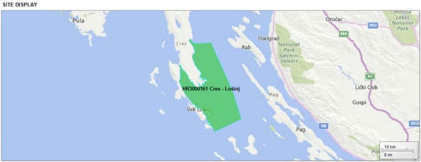
1. INTRODUCTION

Stretching over 18 % of the EU’s land area and almost 9,5% % of its marine territory, NATURA2000 is
the largest coordinated network of protected areas in the world. It offers a haven to Europe's most
valuable and threatened species and habitats.1 Natura 2000 is not a system of strict nature reserves
from which all human activities would be excluded. While it includes strictly protected nature
reserves, most of the land remains privately owned. The approach to conservation and sustainable
use of the Natura 2000 areas is much wider, largely centered on people working with nature rather
than against it. However, Member States must ensure that the sites are managed in a sustainable
manner, both ecologically and economically.

Natura 2000 is a network of core breeding and resting sites for rare and threatened species, and
some rare natural habitat types which are protected in their own right. The aim of the network is to
ensure the long-term survival of Europe's most valuable and threatened species and habitats, listed
under both the Birds Directive (79/409/EEC; 2009/147/EC) and the Habitats Directive (92/43/EEC).
Under NATURA2000 Member States designate Special Protection Areas (SPAs) under the Birds
Directive and Sites of Community Importance (SCIs) under Habitat Directive (Member States must
designate them as Special Areas of Conservation (SACs), as soon as possible and within six years at
most).

Article 6 is one of the most important articles in the Habitats Directive as it defines how Natura 2000
sites are managed and protected. Paragraphs 6(1) and 6(2) require that, within Natura 2000,
Member States:

      •   Take appropriate conservation measures to maintain and restore the habitats and species for
          which the site has been designated to a favourable conservation status;

      •   Avoid damaging activities that could significantly disturb these species or deteriorate the
          habitats of the protected species or habitat types.

Prerequisite for implementation of above-mention paragraphs and therefore efficient management
of NATURA2000 sites is detailed database of biological, ecological and other relevant information
about targeted species/habitats and ecosystem in general with their key ecological processes and
pressures/threats. Furthermore, management plan with conservation goals need to be clearly
defined and its achievement monitored by relevant/adequate monitoring parameters.

In this Report, characterization of the seven selected Adriatic Natura 2000 sites has been done: 4 SCIs
- HR3000469 Viški akvatorij, HR3000161 Cres-Lošinj, HR4000015 Malostonski zaljev, IT3330009
Trezze San Pietro e Bardelli, 2 SACs - IT3250047 Tegnue di Chioggia and IT 3270017 Delta del Po:
tratto terminale e delta Veneto and 1 SPA IT3270023 Delta del Po.

These last two sites, both included in the wider Regional Park of the Po Delta, constitute formally two
different Natura 2000 sites. Actually, they overlap almost completely, sharing most of the habitats

1
    http://ec.europa.eu/environment/nature/natura2000/index_en.htm
                                                    4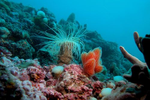
and species in the region and they are also managed by the same authority (the Institution for parks
and biodiversity management Po Delta Emilia Romagna). For these reasons in the main project
output indicators they are merged into one unique indicator, for a total of six.

Analysis of the ongoing monitoring activities and conservation strategies was done as well as the
analysis of habitats, key ecological processes, the target species and other relevant species of these
sites.

The Report was developed by using information from questionnaires shared among project partners,
Standard Data Forms for selected NATURA2000 sites, other scientific sources and online portals.
Some data were collected by direct communication with project partners and relevant scientist.

Detail description of each of selected sites as well as SWOT analysis were done. At the end,
conclusions and recommendations were done.

Note:

There are some discrepancy between information collected via questionnaires and those found on
internet sites regarding conservation measures for those NATURA2000 sites which were designated
as SACs (IT3250047 Tegnùe di Chioggia, IT3270017 Delta del Po: tratto terminale e delta Veneto).

To fullfill requirement to become SAC, conservation measures need to be applied for the
maintenance or restoration, at a favourable conservation status, of the natural habitats and/or the
populations of the species for which the site is designated).

                                                  5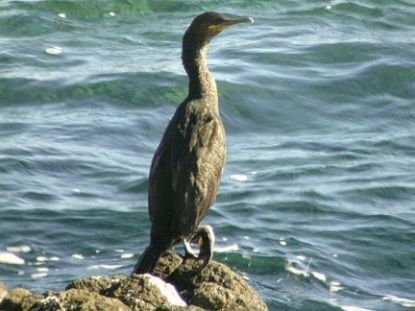
Figure: Map of the Natura2000 sites considered in the ECOSS project

                                                 6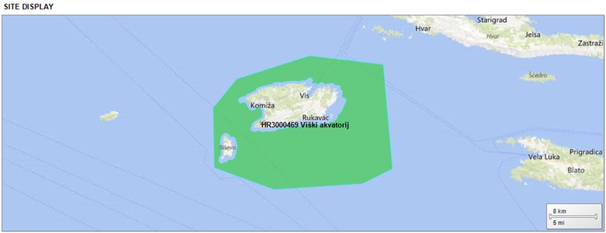
2. CHARACTERIZATION OF THE SELECTED NATURA2000 SITES
2.1. HR3000469 Viški akvatorij

2.1.1. Information about the site
SITE IDENTIFICATION
TYPE                          B
FIRST COMPILATION             12/1/2012
RESPONDENT                    Ministry of Environment Protection and Energy, Directorate for
                              Nature Protection, Radnička cesta 80/VII, Zagreb

                              Ex: Croatian Agency for the Environment and Nature, Radnička cesta
                              80/VII, Zagreb

DATE SITE PROPOSED AS         7/1/2013
SCI CONFIRMED AS SCI
DATE                          12/1/2014
National legal reference of
                              no
SAC designation:
SITE LOCATION
SITE CENTRE LOCATION (decimal degrees)
Longitude                     16,19338531
Latitude                      43,00452649
AREA (HA)                     51876,6486
MARINE AREA (%)               100
SITE LENGTH (km)              0
ADMINISTRATIVE REGION CODE AND NAME
Nuts level II code            HRZZ
Region Name                   Extra-Regio
BIOGEOGRAPHICAL REGION(S)

                                                 7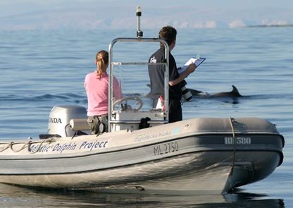
Region Code                    16
Region Name                    Marine Mediterranean
SITE DESCRIPTION
General site character         This large marine site covers a wider marine area around the Island of
                               Vis and the Island of Biševo, except the marine areas surround the
                               same islands in a buffer 500 m from the coast, which make other
                               NATURA 2000 sites. This marine site has an area of 51.888,50 hectares.

Habitat class                  NO1 Marine areas, Sea inlets (100%)
Threats, pressures and         D03.02 Shipping lanes (N/L)
activities with impacts on     E03 Discharges (N/L)
site                           F01 Marine and Freshwater Aquaculture (N/L/i)
                               F02 Fishing and harvesting aquatic resources (N/M)
                               G01.01.01 motorized nautical sports (N/M)
                               H03.03 marine macro-pollution (i.e. plastic bags, styrofoam) (N/M)
                               H05.01 Garbage and solid waste (N/M)
                               H06.01 Noise nuisance, noise pollution (N/M)

SITE PROTECTION STATUS
Designation types at national and regional level
Code/Cover                                                        -
Relation of the described site with other sites
Designated at national and regional level
Type code/Site name                                               -
Designated at international    In 2003, the international ecological organization World Wildlife Fund
level                          has declared the Vis archipelago one of the 10 „last paradise oases of
                               the Mediterranean“ thus including it, together with the islands of Mljet
                               and Lastovo, in the „Adriatic Blue Corridor“, based on scientific
                               research which revealed that this maritime zone has the largest
                               biodiversity in the Mediterranean.

                               In 2019, due to significant geological and geomorphological
                               importance of Vis archipelago, it has been designated officially as a
                               UNESCO Global Geopark.
SITE MANAGEMENT
Managing authority             Public Institution „More i Krš“/“Sea and Karst“
                               www.dalmatian-nature.hr
Management plan                no

                                                   8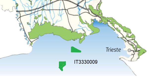
Monitoring activities /run    Research on bottlenose dolphins started in 2007 and has been
by Managing authority or      conducted in summer seasons. The research effort is highest within the
other entity                  Viški akvatorij (HR3000469) site, and surrounding area is also covered
                              with less intensity (Figure 2). Primary method is collection of photo-
                              identification data from small research vessels. The database contains
                              reference dorsal fin catalogue, information on capture histories of
                              identified individuals and research effort data. From these, spatio-
                              temporal distribution maps are created and demographic parameters
                              are estimated, as basic information on the status of the local
                              bottlenose dolphin community. Based on the results, the Viški akvatorij
                              Natura 2000 site is a part of the home range of around 400 bottlenose
                              dolphins, smaller proportion of which show long-term residency to this
                              area.

Ecological parameters         Population dynamics, Population structure, Habitat use, Spatial
monitored                     distribution, Foraging, Underwater noise

Target goals at the           preservation of favourable state of natural habitat for the common
NATURA 2000 site              bottlenose dolphins

Key ecological processes      Not known
Key management                Key management issue is the lack of management plan
issues/goals at the
NATURA 2000

Institutions engaged in the   Plavi svijet – institut za istraživanje i zaštitu mora/Blue World -
monitoring activities of      Institute of Marine Research and Conservation
target species                Kaštel ul. 24, 51551, Veli Lošinj
                              www.blue-world.org
Institutions engaged in the   Institut za oceanografiju i ribarstvo/Institute for Oceanography and
monitoring activities of      Fisheries
other species/habitats and    Šetalište I. Meštrovića 63, 21000 Split
other indicators              www.izor.hr
Web page with description     http://natura2000.eea.europa.eu/Natura2000/SDF.aspx?site=HR30004
of the NATURA 2000 site       69
and monitoring activities

Are the monitored data in     Blue World Institute is the owner of data. Data is not publicly shared,
the NATURA 2000 site          but available for cooperative research projects.
available and under which
conditions

List and describe             Not defined
performance indicators
monitored at the NATURA

                                                  9
2000 site

Equipment needed that
would improve the
monitoring activities at the
NATURA 2000 site:

Conservation strategies at     The conservation strategy should be generally focused on minimizing
the NATURA 2000 site           negative impacts or preventing potential impacts, as listed in Natura
                               2000 Standard Data Form. Fortunately, none is estimated “high”.
                               Public Instutitution „Sea and Karst” generally has small possibilities for
                               active management of this site, due to its own capacities, as well as
                               legal authorities. Besides, some of potential threats are far beyond any
                               local level, such as marine macro-pollution. Under above conditions, PI
                               sees its main role in awareness raising activities among local
                               population and tourist agencies aimed on minimizing disturbance of
                               dolphins by boat traffic, either intentionally (dolphin watching for
                               tourists) or unintentionally due to heavy traffic. Intentional killing of
                               dolphins by fishermen is not listed in official list of threats, although
                               that possibility should not be neglected. In any possible activity PI
                               should closely collaborate with Blue World Institute, an organisation
                               specialised for dolphin conservation.

Other NATURA2000 site(s)       In the submarine zone of the Vis archipelago there are 8 more Natura
                               2000 areas included in NATURA2000 network: HR3000096 - the south-
                               eastern side of the island of Vis; HR3000097-The island of Vis-
                               submarine zone; HR3000098-Biševo the marine zone; HR3000099-
                               Brusnik and Svetac; HR3000100-The islet of Jabuka-submarine zone;
                               HR3000121-Palagruža submarine zone; HR3000122-The islet of
                               Galijula; HR3000477-Reefs in the submarine valley of the island of
                               Jabuka.
                               https://geopark-vis.com/en/heritage/naturale-heritage/natura-2000

                                                   10
2.1.2. Information about the target species
Photo: Blue World Institute
The target species of the site is bottlenosed dolphin (Tursiops truncatus). The site evaluation for its
population is listed in following table.
Species Population on site Site assessment
Size A/B/C/D A/B/C
Scientific
D.qual
Global
G Code NP T
Max
Min
name
Pop.
Con.
Unit
Iso.
Cat
Tursiops
M 1349 0 p 250 477 i M B A C B
truncatus
Group: A = Amphibians, B = Birds, F = Fish, I = Invertebrates, M = Mammals, P = Plants, R = Reptiles
NP: Value "1" indicated that a species is no longer present in the site
Type: p = permanent, r = reproducing, c = concentration, w = wintering
Unit: i = individuals, p = pairs or other units according to the Standard list of population units and codes in accordance with
Article 12 and 17 reporting (see reference portal)
Abundance categories (Cat.): C = common, R = rare, V = very rare, P = present - information is provided if data are deficient
(DD) or in addition to population size information
Data quality: G = 'Good' (e.g. based on surveys); M = 'Moderate' (e.g. based on partial data with some extrapolation); P =
'Poor' (e.g. rough estimation); “DD” = Data deficient (category used when not even a rough estimation of the population size can
be made; “Abundance categories” is used instead of population size)
Population (Size and density of the population of the species present on the site in relation to the populations present within
national territory): A = >15%, B = 2-15%, C =By analysis of data collected in a period 2007 – 2014 it is concluded that the population is stable
during the study period. Based on data collected in 2014, the population abundance estimate is 278
(95% CI=208-413) bottlenose dolphins (Miočić et al., 20142).
2.1.3. Other important species
In the area of the Vis Archipelago some other Cetacean species are seen: the striped dolphin
(Stenella coeruleoalba), Fin whale (Balaenoptera physaus) and Risso's dolphin (Grampus griseus). It is
area of high underwater biodiversity importance (Žuljević et al., 2009)3.
During Blue World Institute’s research4, several other species were seen: giant devil rays (Mobula
mobular), blue-fin tuna (Thunnus thynnus), swordfish (Xiphias gladius), Eleonora’s falcons (Falco
eleonorae), Mediterranean flying fish (Cheilopogon heterurus), Yelkouan shearwater (Puffinus
yelkouan) and Scopoli’s shearwaters (Calonectris diomedea), and European shags (Phalacrocorax
aristotelis) among others. There are also occasional reports of sightings of monk seal (Monachus
monachus), great white shark (Carcharodon carcharias) and other endangered animals.
2.1.4. SWOT analysis
STRENGHTS WEAKNESSES
Monitoring system for target species No management plan
established No official conservation strategy
Conservation of target species defined as Key ecological processes not known
“Excellent” Performance indicators not defined
Great knowledge on target species population No proper surveillance system
and its trends No database of other species/habitats
High seasonal pressure (tourism)
OPPORTUNITIES THREATS
EU funding for human and technical resources Climate change (increase of temperature may
Better networking/data exchange within lead to disbalance)
Adriatic-Ionian basin Additional tourism pressure due to
Coordination of Management with newly attractiveness of newly established GEOPARK
established GEOPARK Threats, pressures and activities with impacts
on site – see 2.1.1.
2
Miočić-Stošić, J., Pleslić, G., Rako Gospić, N., Fortuna, C. M., Holcer, D. 2015. Procjena brojnosti zajednice
dobrih dupina (Tursiops truncatus) Viškog akvatorija. U: Zbornik sažetaka priopćenja Dvanaestog hrvatskog
biološkog kongresa. Hrvatsko biološko društvo, Sv. Martin na Muri, str. 207-208.
3
Žuljević, A., Despalatović M., Antolić B., Cvitković I., Nikolić V., Dadić V., Vidjak O., Skejić S., Muslim S., Holcer
D. (2009) Morska bioraznolikost otoka Biševa i jugoistočne strane otoka Visa - Stručna podloga za održivo
upravljanje (https://issuu.com/undphr/docs/morska_bioraznolikost)
4
https://www.blue-world.org/what-we-do/where-we-operate/vis-archipelago/
122.2. HR3000161 Cres-Lošinj
2.2.1. Information about the site
SITE IDENTIFICATION
TYPE B
FIRST COMPILATION DATE 12/1/2012
RESPONDENT Ministry of Environment Protection and Energy, Directorate for
Nature Protection, Radnička cesta 80/VII, Zagreb
Ex: Croatian Agency for the Environment and Nature, Radnička
cesta 80/VII, Zagreb
DATE SITE PROPOSED AS SCI 7/1/2013
DATE CONFIRMED AS SCI 12/1/2014
National legal reference of
no
SAC designation:
SITE LOCATION
SITE CENTRE LOCATION (decimal degrees)
Longitude 14,56751043
Latitude 44,59979562
AREA (HA) 52574,6384
MARINE AREA (%) 100
SITE LENGTH (km) 0
ADMINISTRATIVE REGION CODE AND NAME
Nuts level II code HRZZ
Region Name Extra-Regio
BIOGEOGRAPHICAL REGION(S)
Region Code 16
Region Name Marine Mediterranean
SITE DESCRIPTION
13General site character Large marine site located in the Kvarnerić area, around the
sheltered coast and waters of the eastern part of the Lošinj and
Cres archipelago. It is one of the most important feeding and
breeding areas for bottlenose dolphins (Tursiops truncatus) in the
Eastern Adriatic.
Lithostratigraphic units represented on the coast are dolomites
and post sedimentary diagenetic breccia (upper albian, lower
cenomanian - K16, K12), rudist limestones (cenomanian-
maastricht - K21-6). Soils on the coast are rockyground,
anthropogenic soil on karst. The area was created after the
transgression of the sea after the last glaciation; marine shelf;
highly indented coastline.
In July 2006 of preventive protection of a part of the Kvarnerić
region for 3 years as a Special Marine Reserve (Cres-Lošinj Special
Marine Reserve – CLSMR has been declared.
Habitat class NO1 Marine areas, Sea inlets (100%)
Threats, pressures and D03 Shipping lanes, ports, marine constructions (N/H/b)
activities with impacts on site E03.01 Disposal of household / recreational facility waste
(N/M/o)
E03.04 Other discharges (N/L/b)
F01 Marine and Freshwater Aquaculture (N/L/i)
F02 Fishing and harvesting aquatic ressources (N/H/b)
F05 Illegal taking/ removal of marine fauna (N/M/i)
F05.01 Dynamite (N/H/b)
G01.01.01 Motorized nautical sports (N/H/b)
H03.03 Marine macro-pollution (i.e. plastic bags, styrofoam)
(N/H/b)
H06.01 Noise nuisance, noise pollution (N/M/i)
SITE PROTECTION STATUS
Designation types at national and regional level
Code/Cover
Designated at national nad regional level
Type code/Site name
Designated at international level
SITE MANAGEMENT
Public Institution of Primorsko-goranska County „Priroda“/ Javna
ustanova za upravljanje zaštićenim dijelovima prirode Primorsko-
Management authority
goranske županije
https://ju-priroda.hr/
Management plan no
14Monitoring activities /run by Research on bottlenose dolphins started in 1987 and has been
Managing authority or other ongoing since. Until 2004 field work was conducted in summer
entity seasons only, since 2005 it is done year-round. The field work is
mostly concentrated within the Cres-Lošinj site (HR3000161),
with significant parts of surrounding areas also covered, albeit
with less intensity. Primary method is collection of photo-
identification data from small research vessels. The database
contains reference dorsal fin catalogue, information on capture
histories of identified individuals and research effort data. From
these, spatio-temporal distribution maps are created and
demographic parameters are estimated, as basic information on
the status of the local bottlenose dolphin community. Based on
the results, the Cres-Lošinj Natura 2000 site is habitat for around
200 bottlenose dolphins which show long-term residency to this
area. Besides this, other data were collected with various
durations: data on behaviour of dolphin groups, underwater
acoustics, tissue and stomach content samples from stranded
carcasses, UAV based data on dolphins’ morphometry, and
marine traffic and fisheries intensity.
Ecological parameters Population dynamics, Population structure, Habitat use, Spatial
monitored distribution, Foraging, Physical, Underwater noise
Target goals at the NATURA preservation of favourable state of natural habitat for the
2000 site common bottlenose dolphins
Key ecological processes Not known.
Key management issues/goals Key management issue is the lack of management plan
at the NATURA 2000
Institutions engaged in the Plavi svijet – institut za istraživanje i zaštitu mora/Blue World -
monitoring activities Institute of Marine Research and Conservation
Kaštel ul. 24, 51551, Veli Lošinj
www.blue-world.org
Web page with description of http://natura2000.eea.europa.eu/Natura2000/SDF.aspx?site=HR
the NATURA 2000 site and 3000161
monitoring activities
Are the monitored data in the Blue World Institute is the owner of data. Data is not publicly
NATURA 2000 site available shared, but available for cooperative research projects.
and under which conditions
List and describe performance Not defined
indicators monitored at the
NATURA 2000 site
Equipment needed that would Theodolite for monitoring marine traffic in relation to bottlenose
improve the monitoring dolphin spatial distribution and behaviour.
activities at the NATURA 2000
site
15Conservation strategies at the No official strategy defined
NATURA 2000 site
Other NATURA2000 site(s) HR3000014 Ilovik i Sv. Petar
http://natura2000.dzzp.hr/reportpublish/reportproxy.aspx?para
mSITECODE=HR3000014
HR3000026 Dolfin i otoci
http://natura2000.dzzp.hr/reportpublish/reportproxy.aspx?para
mSITECODE=HR3000026
2.2.2. Information about the target species
The target species of the site is bottlenosed dolphin (Tursiops truncatus). The site evaluation for its
population is listed in following table.
Species Population on site Site assessment
Size A/B/C/D A/B/C
Scientific
G Code NP T Unit Cat D.qual
Global
Pop.
Con.
Max
Min
name
Iso.
M Tursiops
1349 0 p 100 209 i P B B C B
truncatus
Group: A = Amphibians, B = Birds, F = Fish, I = Invertebrates, M = Mammals, P = Plants, R = Reptiles
NP: Value "1" indicated that a species is no longer present in the site
Type: p = permanent, r = reproducing, c = concentration, w = wintering
Unit: i = individuals, p = pairs or other units according to the Standard list of population units and codes in accordance with
Article 12 and 17 reporting (see reference portal)
Abundance categories (Cat.): C = common, R = rare, V = very rare, P = present - information is provided if data are deficient
(DD) or in addition to population size information
Data quality: G = 'Good' (e.g. based on surveys); M = 'Moderate' (e.g. based on partial data with some extrapolation); P =
'Poor' (e.g. rough estimation); “DD” = Data deficient (category used when not even a rough estimation of the population size can
be made; “Abundance categories” is used instead of population size)
Population (Size and density of the population of the species present on the site in relation to the populations present within
national territory): A = >15%, B = 2-15%, C =2.2.3. Other important species
This area is an important site for the Mediterranean population of the loggerhead sea turtle (Caretta
caretta), the Mediterranean endemic seagrass (Posidonia oceanica), coral biocenoses, and nesting
sites of the common European Shag (Phalacrocorax aristotelis). Surveys in this region have identified
152 species of marine flora, 303 species of marine invertebrates (7 strictly protected, 9 protected)
and 112 species of fish (19 endangered species in Croatia) within the area6.
2.2.4. SWOT analysis
STRENGHTS WEAKNESSES
Monitoring system for target species No management plan
established No official conservation strategy
Great knowledge on target species population Performance indicators not defined
and its trends No proper surveillance system
Conservation of target species defined as No database of other species/habitats
„good“ High seasonal pressure (tourism)
Awareness raising activities carrying on Key ecological processes not known
Collision of tourism and fishing with
conservation objectives
OPPORTUNITIES THREATS
EU funding for human and technical resources Climate change (increase of temperature may
Better networking/data exchange within lead to disbalance - fishery)
Adriatic-Ionian basin Additional tourism pressure
Plastic pollution of the Adriatic
Threats, pressures and activities with impacts
on site – see 2.2.1.
6
https://www.blue-world.org/what-we-do/our-projects/683-2/
172.3. HR4000015 Malostonski zaljev
2.3.1. Information about the site
SITE IDENTIFICATION
TYPE B
FIRST COMPILATION DATE 12/1/2012
RESPONDENT Ministry of Environment Protection and Energy, Directorate for
Nature Protection, Radnička cesta 80/VII, Zagreb
Ex: Croatian Agency for the Environment and Nature, Radnička
cesta 80/VII, Zagreb
DATE SITE PROPOSED AS SCI 7/1/2013
DATE CONFIRMED AS SCI 12/1/2014
National legal reference of
no
SAC designation:
SITE LOCATION
SITE CENTRE LOCATION (decimal degrees)
Longitude 17,54327831
Latitude 42,92067479
AREA (HA) 5717,2405
MARINE AREA (%) 100
SITE LENGTH (km) 0
ADMINISTRATIVE REGION CODE AND NAME
Nuts level II code HRZZ
Region Name Extra-Regio
BIOGEOGRAPHICAL REGION(S)
Region Code 16
Region Name Marine Mediterranean
SITE DESCRIPTION
18General site character Malostonski zaljev includes the sea area of Dubrovnik-Neretva
County southeast of the line Sreser-Duba to the Kuta bay. The
area is located at the end of the Neretva channel in which the
Neretva river influences. Ecological conditions in the bay depend
mostly on influences from the mainland and partly from the open
sea. External and middle part of the bay are occasionally under
stronger effect of the Neretva freshwater and its inner part is less
affected by freshwater Delta. Strong underwater freshwater
springs in the inner part of the bay have a great impact on hydro-
physical and ecological relationships in the bay. According to the
concentration of nutrients and the amount of phytoplankton, the
bay may qualify as a natural moderate eutrophication system.
Thanks to the specific environmental conditions, the living world
in a bay is extremely rich. From antique times people have been
cultivating shellfish (mussels and oysters) in a bay and today it is
the most important place for the cultivation of oysters in Croatia
(especially European flat oyster Ostrea edulis). The majority of
the benthic algal flora consists of Cystoseira settlements that
grow on the rocky bottom to 5 m of depth. Complete absence of
Posidonia oceanica indicates very poor flora of the deeper
settlements. For the inner part of Malostonski zaljev Bay
characteristic are dense populations of organisms that feed on
plankton by filtering seawater (especially corrals).
The area is part of a Special reserve in the sea Malostonski zaljev
Bay declared in 1983.
Lithostratigraphic units represented around this area are
cretaceous rudist limestones. It was created after the
transgression of the sea after the last glaciation. Presence of
abrasion processes. Characteristic for Malostonski zaljev is low
coast with several coves.
NOTE: Part of the Bay belongs to the City of Neum (Bosnia and
Hercegovina). Neum is the only coastal part of BH and very
attractive tourist area!!!
Habitat class NO1 Marine areas, Sea inlets (99,38%)
NO8 Heath, Scrub, Maquis and Garrigue, Phygrana (0,06%)
N16 Broad-leaved deciduous woodland (0,49%)
N23 Other land (including Towns, Villages, Roads, Waste places,
Mines, Industrial sites) (0,07%)
19Threats, pressures and D03 Shipping lanes, ports, marine constructions (N/H/i)
activities with impacts on site E01 Urbanised areas, human habitation (N/H/i)
E02 Industrial or commercial areas (N/M/i)
F01 Marine and Freshwater Aquaculture (N/H/i)
F05 Illegal taking/ removal of marine fauna (N/M/i)
H01.08 Diffuse pollution to surface waters due to household
sewage and waste waters (N/H/i)
H03 Marine water pollution (N/H/i)
SITE PROTECTION STATUS
Designation types at national and regional level
Code/Cover Special Marine Reserve /14898.97 ha
Designated at national nad regional level
Type code/Site name Bay of Mali Ston - Special Marine Reserve (1983)
Designated at international
level
SITE MANAGEMENT
Managing authority Public Institution for Management of Protected Natural Areas
of the Dubrovnik-Neretva County/ Javna ustanova za
upravljanje zaštićenim dijelovima prirode Dubrovačko-
neretvanske županije
https://zastita-prirode-dnz.hr/
Management plan No. Expected in 2020.7
Monitoring activities /run by Institut za more i priobalje/Institute for Marine and Coastal
Managing authority or other Research is conducting research of water column (4 time per year
entity on 4 stations).
http://www.imp-du.com/en
Ecological parameters Water column parameters measured: temperature, salinity,
monitored oxygen, nutrients, phytoplankton and zooplankton
Target goals at the NATURA Preservation of the favourable state of the key habitats in the
2000 site present surface.
7
Open tender: https://ted.europa.eu/TED/notice/udl?uri=TED:NOTICE:291975-2019:TEXT:HR:HTML
20Key ecological processes Ecological conditions in the bay depend mostly on influences
from the mainland and partly from the open sea. External and
middle part of the bay are occasionally under stronger effect of
the Neretva freshwater and its inner part is less affected by
freshwater Delta. Strong underwater freshwater springs in the
inner part of the bay have a great impact on hydro-physical and
ecological relationships in the bay. According to the
concentration of nutrients and the amount of phytoplankton, the
bay may qualify as a natural moderate eutrophication system.
Thanks to the specific environmental conditions, the living world
in a bay is extremely rich. From antique times people have been
cultivating shellfish (mussels and oysters) in a bay and today it is
the most important place for the cultivation of oysters in Croatia
(especially European flat oyster Ostrea edulis). The majority of
the benthic algal flora consists of Cystoseira settlements that
grow on the rocky bottom to 5 m of depth. For the inner part of
Malostonski Bay characteristic are dense populations of
organisms that feed on plankton by filtering seawater (especially
corrals).
Key management issues/goals The most important is to create a knowledge base of the overall
at the NATURA 2000 ecological present state of the Natura 2000 site that would make
a foundation for a quality management plan for the area.
Through the management plan key management goals will be
tackled, such as collision of aquaculture, tourism and fishing with
conservation objectives.
Institutions engaged in the Institut za more i priobalje/Institute for Marine and Coastal
monitoring activities Research
Kneza Damjana Jude 12, pp 83, 20000 Dubrovnik
http://www.imp-du.com/en
Web page with description of http://natura2000.dzzp.hr/reportpublish/reportproxy.aspx?para
the NATURA 2000 site and mSITECODE=HR4000015
monitoring activities
Are the monitored data in the Dubrovnik-Neretva County – owner of the data
NATURA 2000 site available
and under which conditions:
(data sharing policy?)
List and describe performance not defined
indicators monitored at the
NATURA 2000 site
Equipment needed that would Cameras
improve the monitoring
activities at the NATURA 2000
site:
21Conservation strategies at the Conservation strategies are not defined at the moment. It is
NATURA 2000 site planned to define them through the management plan in the
next couple of years.
Other NATURA2000 site(s) HR5000031 Delta Neretve
http://natura2000.dzzp.hr/reportpublish/reportproxy.aspx?para
mSITECODE=HR5000031
HR2001364 JI dio Pelješca
http://natura2000.dzzp.hr/reportpublish/reportproxy.aspx?para
mSITECODE=HR2001364
2.3.2. Habitat types on the site
ANNEX I HABITAT TYPES SITE ASSESSMENT
CAVES (number) A|B|C|D A|B|C
DATA QUALITY
Representativity
COVER (ha)
Relative surface
Conservation
CODE
NP
PF
Global
NAME
1160 Large shallow inlets and
0 0 5718,76 G B C B B
bays
1170 Reefs 0 0 325 P B C C C
PF: Value "1" indicates the priority form for habitat types that can have a non-priority as well as a priority form (6210, 7130,
9430)
NP: Value "1" indicates a habitat type that no longer exists in the site
Caves: for habitat types 8310, 8330 (caves) the number of caves is entered if estimated surface is not available.
Data quality: G = 'Good' (e.g. based on surveys); M = 'Moderate' (e.g. based on partial data with some extrapolation); P =
'Poor' (e.g. rough estimation)
Representativity (Degree of representativity of the habitat type on the site): A= excellent, B=good, C=significant, D=non-
significant
Relative surface (Area of the site covered by the natural habitat type in relation to the total area covered by that natural habitat
type within the national territory): A = >15%, B = 2-15%, C =2.3.4. SWOT analysis
STRENGHTS WEAKNESSES
Monitoring system of water column established No official management plan nor conservation
Management plan is expected in 2020 strategy
Other important species listed Conservation of target habitats assessed as
Good data quality for Large shallow inlets and „average or reduced conservation“
bays (status of conservation = Good”) Performance indicators not defined
No proper surveillance system
Data quality for “Reefs” = Poor
Not adequate database of target and other
species/habitats
High aquaculture intensity
Collision of aquaculture, tourism and fishing
with conservation objectives
OPPORTUNITIES THREATS
EU funding for human and technical resources Climate change (increase of temperature may
Better networking/data exchange within lead to disbalance of ecosystem)
Adriatic-Ionian basin Threats, pressures and activities with impacts
Cooperation with BH authorities toward better on site listed under 2.3.1.
management of the area
232.4. IT3330009 Trezze San Pietro e Bardelli
2.4.1. Information about the site
SITE IDENTIFICATION
TYPE B
FIRST COMPILATION DATE 09/2013
UPDATE DATE 01/2017
RESPONDENT Regione Autonoma Friuli Venezia Giulia - Direzione Centrale
Infrastrutture e Territorio - Servizio Paesaggio e Biodiversità
DATE SITE PROPOSED AS SCI 09/2013
DATE CONFIRMED AS SCI 12/20148
National legal reference of SAC no
designation:
SITE LOCATION
SITE CENTRE LOCATION (decimal degrees)
Longitude 13.410000
Latitude 45.630000
AREA (HA) 2380
MARINE AREA (%) 100
SITE LENGTH (km) 0
ADMINISTRATIVE REGION CODE AND NAME
Nuts level II code ITD4
Region Name Friuli Venezia Giulia
8
https://www.regione.fvg.it/rafvg/cms/RAFVG/ambiente-territorio/tutela-ambiente-gestione-risorse-
naturali/FOGLIA203/FOGLIA118/
24BIOGEOGRAPHICAL REGION(S)
Region Code
Region Name Continental
SITE DESCRIPTION
General site character The rocky outcrops known locally as trezze are characterized by
substrates of various origins (clastic sedimentary, sedimentary
sediments, organogenic) and with extensions ranging from a few
to several hundred meters. The geological nature of the outcrops
reveals that not all of them can be assimilated to
bioconstructions, but there are also slabs deriving from the
cementation of sand or rocks by methane gas. From recent
investigations about 250 outcrops have been identified only in
the Gulf of Trieste between Punta Sdobba and Punta
Tagliamento; the most widespread range of these outcrops is on
the seabed in front of the lagoons of Grado and Marano at a
distance from the coastline of between 2 and 17 km, and a depth
varying between 8.3 and 21.5 m. From the bibliography it
emerges that the areas involved in rocky outcrops extend from
the Gulf of Trieste to the coast of Ancona, along the entire north-
western and western coast of the North Adriatic. The calcareous
concretions are attributable to Corallinaceous algae and
secondly to Briozoa, Molluscs (Arca noae, Chama gryphoides),
Anthozoans (Cladocora caespitosa), Serpulids (Serpula
concharum, Serpula vermicularis, Pomatoceros triqueter, Rotula
sp.plur.). The typology of the San Pietro and Bardelli trezze is of
the Tabular type consisting of a fractioned set of many outcrops
of the same type, however there are some major elements of
larger dimensions.
Habitat class NO1 Marine areas, Sea inlets (100%)
Threats, pressures and D03.01 Port areas/M/o
activities with impacts on site F02.02 Professional active fishing /M/o
F02.03 Leisure fishing /L/o
F03.02.03 Trapping, poisoning, poaching /L/i
G01 Outdoor sports and leisure activities, recreational activities
/L/i
G01.01 Nautical sports /M/o
H01.04 Diffuse pollution to surface waters via storm overflows or
urban run-off/M/o
SITE PROTECTION STATUS
Designation types at national
and regional level
Code/Cover IT00 (100%)
Designated at national nad
regional level
Type code/Site name
25Designated at international
level
SITE MANAGEMENT
Managing authority Regione Autonoma Friuli Venezia Giulia - Direzione Centrale
Infrastrutture e Territorio - Servizio Paesaggio e Biodiversità
https://www.regione.fvg.it/rafvg/cms/RAFVG/ambiente-
territorio/tutela-ambiente-gestione-risorse-naturali/FOGLIA203/
Management plan no
Monitoring activities /run by occasional monitoring activities are performed at the site
Managing authority or other
entity
Ecological parameters Coralligenous outcrops: species spatial distribution, richness,
monitored density, coverage, community structure and dynamic (see Ponti
et al., 2010; Curiel et al., 2012; Falace et al., 2015)
Target goals at the NATURA lack a management authority as well as a conservation and
2000 site management plan. The rationale for their establishment is the
protection and conservation of these unique North Adriatic
habitats. They represent a biodiversity hotspot in a generally flat,
sandy or muddy sea bottom. The coralligeneous reefs have great
importance for several pelagic and demersal species, both as
spawning areas and nurseries, and as refugia for adult
specimens.
Key ecological processes Reproduction and settlement of several benthic, pelagic and
demersal species
Key management issues/goals lack a management authority as well as a conservation and
at the NATURA 2000 management plan: this is at present the main management issue
that needs to be solved before shifting the attention to other
management issues/goals
Institutions engaged in the OGS, UNITS, ARPA-FVG
monitoring activities
Web page with description of https://www.regione.fvg.it/rafvg/cms/RAFVG/ambiente-
the NATURA 2000 site and territorio/tutela-ambiente-gestione-risorse-
monitoring activities naturali/FOGLIA203/FOGLIA118/
Are the monitored data in the Data is not publicly shared, but available for cooperative
NATURA 2000 site available research projects.
and under which conditions:
List and describe performance None
indicators monitored at the
NATURA 2000 site
Equipment needed that would Underwater photocamera, ROV, CTD.
improve the monitoring
activities at the NATURA 2000
site
26Conservation strategies at the lack a management authority as well as a conservation and
NATURA 2000 site management plan, thus no conservation strategy is enacted at
present.
Other NATURA2000 site(s) -
2.4.2. Habitat types on the site
It protects 2 habitat types of the Habitats Directive.
ANNEX I HABITAT TYPES SITE ASSESSMENT
A|B|C|D A|B|C
CAVES (number)
DATA QUALITY
Representativity
COVER (ha)
Relative surface
Conservation
CODE
NP
PF
NAME
Global
1170 Reefs 80 M A C A A
1110 Sandbanks which are
slightly covered by sea 20 M B C B B
water all the time
PF: Value "1" indicates the priority form for habitat types that can have a non-priority as well as a priority form (6210, 7130,
9430)
NP: Value "1" indicates a habitat type that no longer exists in the site
Caves: for habitat types 8310, 8330 (caves) the number of caves is entered if estimated surface is not available.
Data quality: G = 'Good' (e.g. based on surveys); M = 'Moderate' (e.g. based on partial data with some extrapolation); P =
'Poor' (e.g. rough estimation)
Representativity (Degree of representativity of the habitat type on the site): A= excellent, B=good, C=significant, D=non-
significant
Relative surface (Area of the site covered by the natural habitat type in relation to the total area covered by that natural habitat
type within the national territory): A = >15%, B = 2-15%, C =Phalacrocorax
B A392 w C B B C B
aristotelis desmarestii
Phalacrocorax
B A392 c C B B C B
aristotelis desmarestii
B A464 Puffunus yelkouan c P C B C C
F 1103 Alosa fallax c P D
M 1349 Tursiops truncatus c P C B C C
R 1224 Caretta caretta c P C B C C
Group: A = Amphibians, B = Birds, F = Fish, I = Invertebrates, M = Mammals, P = Plants, R = Reptiles
NP: Value "1" indicated that a species is no longer present in the site
Type: p = permanent, r = reproducing, c = concentration, w = wintering
Unit: i = individuals, p = pairs or other units according to the Standard list of population units and codes in accordance with
Article 12 and 17 reporting (see reference portal)
Abundance categories (Cat.): C = common, R = rare, V = very rare, P = present - information is provided if data are deficient
(DD) or in addition to population size information
Data quality: G = 'Good' (e.g. based on surveys); M = 'Moderate' (e.g. based on partial data with some extrapolation); P =
'Poor' (e.g. rough estimation); “DD” = Data deficient (category used when not even a rough estimation of the population size can
be made; “Abundance categories” is used instead of population size)
Population (Size and density of the population of the species present on the site in relation to the populations present within
national territory): A = >15%, B = 2-15%, C =2.4.5. SWOT analysis
STRENGHTS WEAKNESSES
Valuable corallligeneous habitats No management plan
Occasional monitoring activities performed at No official conservation strategy
the site
Performance indicators monitored at the
Database of coralligenous outcrops (Reefs): NATURA 2000 site not defined
species spatial distribution, richness, density,
More detailed database on target species
coverage, community structure and dynamic
missing (size of population, data quality,..)
Conservation of target species and habitats
asses as „excellent“ and „good“
Other important species listed
OPPORTUNITIES THREATS
EU funding for human and technical resources Climate change (increase of temperature may
lead to disbalance)
Better networking/data exchange within
Adriatic-Ionian basin Threats are listed in 2.4.1.
292.5. IT3250047 Tegnùe di Chioggia
2.5.1. Information about the site
SITE IDENTIFICATION
TYPE B
FIRST COMPILATION DATE 09/2010
UPDATE DATE 10/2013
RESPONDENT Regione Veneto Segreteria Regionale per il Bilancio - Unità di
Progetto Foreste e Parchi
DATE SITE PROPOSED AS SCI 10/2010
National legal reference of SAC 08/20189
designation:
SITE LOCATION
SITE CENTRE LOCATION (decimal degrees)
Longitude 12.410000
Latitude 45.202500
AREA (HA) 2655.0000
9
https://www.gazzettaufficiale.it/atto/serie_generale/caricaDettaglioAtto/originario?atto.dataPubblicazioneGaz
zetta=2018-08-17&atto.codiceRedazionale=18A05429&elenco30giorni=true
30MARINE AREA (%) 100
SITE LENGTH (km) 35
ADMINISTRATIVE REGION CODE AND NAME
Nuts level II code
Region Name
BIOGEOGRAPHICAL REGION(S)
Region Code
Region Name Continental
SITE DESCRIPTION
General site character Marine environment consisting of Coralligeneous outcrops
of variable extension (from the few square meters of the
smallest outcrops up to over a thousand square meters)
locally called tegnùe or tresse. It is possible to identify
outcrops of great extension and discrete elevation that
constitute the only hard substrates of natural origin in a
mainly sandy-silty bottom. The presence of these structures
provides a support on which sessile organisms can be
installed. The occasional presence of Chelonia mydas has
been found, although with non-significant populations.
On 3 August 2002, Zona di Tutela Biologica - ZTB was
established by Ministerial Decree. Both professional and
sport fishing are prohibited and recreational diving is
regulated, allowing anchoring exclusively to special buoys
upon notice to the association that manages it.
Habitat class NO1 Marine areas, Sea inlets (100%)
Threats, pressures and
Not available
activities with impacts on site
SITE PROTECTION STATUS
Designation types at national
and regional level
Code/Cover IT07 (100%)
Designated at national and regional level
Type code/Site name Biological Protection Zone / Zona di Tutela Biologica
(GU n. 193 19.08.2002)
Designated at international
level
SITE MANAGEMENT
Managing authority Regione Veneto Segreteria Regionale per il Bilancio - Unità di
Progetto Foreste e Parchi
https://www.regione.veneto.it/web/agricoltura-e-
foreste/parchi-biodiversita-e-foreste
Management plan no
31Monitoring activities /run by Occasional monitoring activities are performed at the site
Managing authority or other
entity
Ecological parameters Species spatial distribution, richness, density, coverage,
monitored community structure and dynamic (see Ponti et al., 2010;
Curiel et al., 2012; Falace et al., 2015)
Target goals at the NATURA lack a management authority as well as a conservation and
2000 site management plan. The rationale for their establishment is
the protection and conservation of these unique North
Adriatic habitats. They represent a biodiversity hotspot in a
generally flat, sandy or muddy sea bottom. The reefs have
great importance for several pelagic and demersal species,
both as spawning areas and nurseries, and as refugia for
adult specimens.
Key ecological processes Reproduction and settlement of several benthic, pelagic and
demersal species
Key management issues/goals lack a management authority as well as a conservation and
at the NATURA 2000 management plan: this is at present the main management
issue that needs to be solved before shifting the attention to
other management issues/goals
Institutions engaged in the OGS, UNITS, ARPA-FVG
monitoring activities
Web page with description of http://www.arpa.veneto.it/temi-ambientali/acqua/acque-
the NATURA 2000 site and marino-costiere/approfondimenti/tegnue-alto-adriatico
monitoring activities
Are the monitored data in the Data is not publicly shared, but available for cooperative
NATURA 2000 site available research projects.
and under which conditions:
List and describe performance None
indicators monitored at the
NATURA 2000 site
Equipment needed that would Underwater photocamera, ROV, CTD.
improve the monitoring
activities at the NATURA 2000
site
Conservation strategies at the Lack a management authority as well as a conservation and
NATURA 2000 site management plan, thus no conservation strategy is enacted
at present
Some activities are forbidden/regulated: Both professional
and sport fishing are prohibited and recreational diving is
regulated, allowing anchoring exclusively to special buoys
upon notice to the association that manages it (Ordinance
3232/06 of the Coast Guard of Chioggia).
2.5.2. Habitat types on the site
It protects 1 habitat type of the Habitats Directive.
ANNEX I HABITAT TYPES SITE ASSESSMENT
A|B|C|D A|B|C
CAVES (number)
DATA QUALITY
Representativity
COVER (ha)
Relative surface
Conservation
CODE
NP
PF
NAME
Global
1170 Reefs 138,11 M B C B B
PF: Value "1" indicates the priority form for habitat types that can have a non-priority as well as a priority form (6210, 7130,
9430)
NP: Value "1" indicates a habitat type that no longer exists in the site
Caves: for habitat types 8310, 8330 (caves) the number of caves is entered if estimated surface is not available.
Data quality: G = 'Good' (e.g. based on surveys); M = 'Moderate' (e.g. based on partial data with some extrapolation); P =
'Poor' (e.g. rough estimation)
Representativity (Degree of representativity of the habitat type on the site): A= excellent, B=good, C=significant, D=non-
significant
Relative surface (Area of the site covered by the natural habitat type in relation to the total area covered by that natural habitat
type within the national territory): A = >15%, B = 2-15%, C =Species Population on site Site assessment
Size A/B/C/D A/B/C
G Code Scientific name NP T Unit Cat D.qual
Global
Pop.
Con.
Max
Min
Iso.
M 1349 Tursiops truncatus c P D
R 1224 Caretta caretta c P D
Group: A = Amphibians, B = Birds, F = Fish, I = Invertebrates, M = Mammals, P = Plants, R = Reptiles
NP: Value "1" indicated that a species is no longer present in the site
Type: p = permanent, r = reproducing, c = concentration, w = wintering
Unit: i = individuals, p = pairs or other units according to the Standard list of population units and codes in accordance with
Article 12 and 17 reporting (see reference portal)
Abundance categories (Cat.): C = common, R = rare, V = very rare, P = present - information is provided if data are deficient
(DD) or in addition to population size information
Data quality: G = 'Good' (e.g. based on surveys); M = 'Moderate' (e.g. based on partial data with some extrapolation); P =
'Poor' (e.g. rough estimation); “DD” = Data deficient (category used when not even a rough estimation of the population size can
be made; “Abundance categories” is used instead of population size)
Population (Size and density of the population of the species present on the site in relation to the populations present within
national territory): A = >15%, B = 2-15%, C =You can also read