Regional Weather and Climate Guide - Regional Weather and Climate ...
←
→
Page content transcription
If your browser does not render page correctly, please read the page content below
Regional
                                                                                      Weather and
                                                                                     Climate Guide

In the last 30 years in Central Tablelands
    Annual rainfall has been relatively stable
    Dry years have occurred eight times and wet years have occurred eight times
    Rainfall has decreased in the autumn and spring months
    Summer rainfall has been reliable, autumn has been unreliable
    The autumn break usually occurs around the end of May
    Spring frosts have been more common and have been occurring later
    There have been more hot days, with more consecutive days above 38 °C.

                                                                     The Central Tablelands at a glance
                                                                             The Central Tablelands region covers
                                                                             over 3 million hectares, with 78% of
                                                                             land under agricultural production.
                                                                             The region supports a diverse mix of
                                                                             agricultural enterprises. Grazing,
                                                                             predominantly sheep and cattle, and
                                                                             broadacre cropping are the two largest
                                                                             industries, along with vegetables, pome
                                                                             and stone fruit, wine and table grapes
                                                                             and nursery (cut flowers). Agricultural
                                                                             production in the region was valued at
                                                                             $678 million in 2017–18.
    Natural      Low Level    Dryland      Irrigated    Intensive   Water
    Environments Production   Production   Production   Uses        Bodies

A guide to weather and climate in the Central Tablelands
Primary producers make decisions using their knowledge and expectations of regional weather pat-
terns. The purpose of this guide is to provide an insight into the region’s climate and an understanding
of changes that have occurred through recent periods. This information can potentially assist primary
producers and rural communities make better informed decisions for their business and livelihoods. This
guide is part of a series of guides produced for every Natural Resource Management area around Australia.

                                    A climate guide for agriculture
                                    Central Tablelands, New South Wales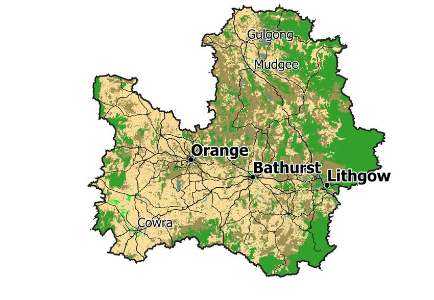
Annual Rainfall
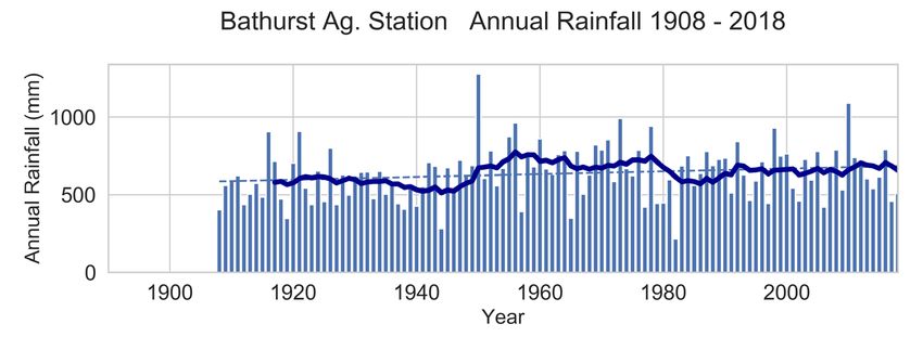
Annual rainfall in the Central Tablelands has been relatively stable
Annual rainfall in the Central
Tablelands has been relatively
stable, decreasing by around 30
mm (4%) from about 750 mm to
about 720 mm over the past 30
years (1989–2018) when compared
to the previous 30 years (1959–
1988). The charts show annual
rainfall (blue bars) with a 10-year
running average (the solid blue
line) for Bathurst and Cowra.
Although the average annual
rainfall has remained unchanged,
it still fluctuates from year to year
with natural variability.
In the past 30 years, dry years
(lowest 30%) and wet years
(highest 30%) have both occurred
eight times, while the remaining
years were in the average range.
Note the Millennium drought
accounted for four of these dry
years in the recent period. During
the previous 30-year period (1959–
1988), dry years occurred six times
and wet years occurred 13 times.

    For more information on future projections,               Want to know more about the guides?
   visit the Climate Change in Australia website               Try Frequently Asked Questions at
     > www.climatechangeinaustralia.gov.au                 > www.bom.gov.au/climate/climate-guides/

Rainfall is most reliable in summer and least reliable in autumn
Rainfall reliability maps for the past 30 years (1989–2018) show summer rainfall has been moderately reliable
across the region (blue areas), with usually only about 70 mm difference from one year to the next. This is
in contrast to winter and spring rainfall, which has been less reliable (beige areas). Autumn rainfall has been
unreliable across the region (red areas), and although there have been some wet autumns in the past 30
years, autumn rainfall has not been reliable from year to year.

  Winter                      Spring                     Summer                      Autumn

2 A climate guide for agriculture Central Tablelands, New South Wales
Rainfall Timing
Rainfall has decreased in the autumn and spring months
Rainfall in the autumn and spring
months decreased at Lithgow
and Mudgee between 1989–2018
(orange bars) compared with
1959–1988 (blue bars).
Over the past 30 years, winter
growing season rainfall (April to
October inclusive) for Mudgee
was 325 mm; 35 mm lower than
the 360 mm average for the
previous 30-year period (1959–
1988). For Lithgow, growing
season rainfall has declined 75
mm over the same period.

                  For more information on the latest observations and science behind
                       these changes, refer to the State of the Climate Report
                              > www.bom.gov.au/state-of-the-climate/

Timing of the autumn break in the Central Tablelands region
                                                         In the Central Tablelands, the autumn break can be
                                                         defined as at least 25 mm of rainfall over three days,
                                                         prior to the commencement of sowing. The map
                                                         shows that over the past 30 years (1989–2018), the
                                                         break typically occurred before the end of May or in
                                                         early June (blue to green areas).
                                                         In the last 30 years, the average autumn break has
                                                         been occurring about between two weeks and one
                                                         month later than it did in the period 1959-1988.

                                    A climate guide for agriculture Central   Tablelands, New South Wales 3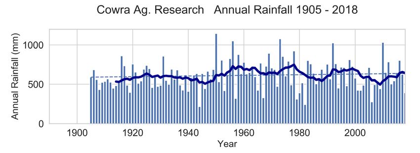
A climate guide for agriculture Central Tablelands, NSW

      Frost
Later and more frequent frosts
The number of potential frosts has increased
at Cowra and Mudgee between 1989–2018
(orange bars) compared with 1959–1988 (blue
bars). Frost frequency increased in spring,
with an average of five more spring nights at
Mudgee and two more spring nights at Cowra
with the potential for frost between 1989–2018
compared to 1959–1988.
Cowra’s frost risk has typically ended by the
second week of October, whereas Mudgee’s
frost risk usually ends about a week and a half
later. Both locations have seen potential frost
nights as late as the first week of November.
The latest potential frost night recorded for
Mudgee was 24 November 1990.
More frosty nights have tended to occur
through dry winter and spring periods, when
soil moisture is low and cloud cover
infrequent. On average, the region has had
around 20 more total frost nights during a dry
winter and spring than during wetter seasons.
However, when comparing just spring frosts,
the difference from wet to dry years was small.

      Temperature
Central Tablelands experienced more hot days in the past 30 years
The chart shows the annual
number of days above 38 °C (red
bars), with a 10-year running
average (solid red line) for Cowra.
Cowra experienced an average
of six days per year above 38 °C
between 1989–2018, compared to
an average of only three days per
year above 38 °C between
1959–1988. Since 2013,
unprecedented temperatures of
43 °C have been recorded for
Cowra six times.
Before 2013, the last time the          above 38 °C have also been more                  more days in a row above 38 °C.
temperature at Cowra exceeded           frequent in the past 30 years.                   A run of five or more days above
43 °C was in 1939.                      In 1997, 2014 and 2019, Cowra                    38 °C is unusual at Cowra and had
Instances of consecutive days           experienced periods of five or                   not happened since 1952.
  Regional Weather and Climate Guides are produced as a partnership between Bureau of Meteorology, CSIRO and FarmLink
                                                     © 2019 Bureau of Meteorology and the CSIRO. The information contained in this
                                                     publication cannot be reproduced without the written permission of Bureau of
                                                     Meteorology and the CSIRO. Requests and enquiries concerning reproduction and
                                                     rights should be addressed to the Bureau of Meteorology. DISCLAIMER: The infor-
                                                     mation contained in this publication is offered by the Bureau of Meteorology and
                                                     CSIRO solely to provide general information. While all due care has been taken in
                                                     compiling the information, the Bureau of Meteorology and CSIRO and its employ-
                                                     ees, accept no liability resulting from the interpretation or use of the information.
                                                     Information contained in this document is subject to change without notice.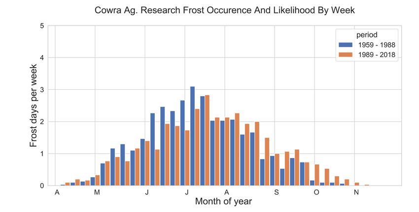


You can also read


