RELEASE NOTES MAPINFO PRO VERSION 16.0.4 - CONTENTS: PITNEY BOWES
←
→
Page content transcription
If your browser does not render page correctly, please read the page content below

MapInfo Pro
Version 16.0.4

Release Notes

Contents:

MapInfo Pro 16.0.4 Release Notes                   2
System Requirements                                2
Upgrading MapInfo Pro                              2
Advanced Installation for System Administrators    3
MapInfo Pro 16.0.4                                 4
MapInfo Pro 16.0.3                                 5
MapInfo Pro 16.0.2                                12
MapInfo Pro 16.0.1                                16
MapInfo Pro 16.0.4 Release Notes

MapInfo Pro 16.0.4 Release Notes

      MapInfo Pro 16.0.4 is a cumulative Maintenance Release update that also include updates supplied
      with MapInfo Pro 16.0.1, 16.0.2 and 16.0.3.
      This document provides information about the resolved issues that are important to MapInfo Pro
      users.

System Requirements

      This product is tested on the following Microsoft Windows Desktop Operating Systems:
      •   Windows 10 64-bit
      •   Windows 8.1 64-bit
      •   Windows 7 Ultimate 64-bit SP1
      •   Windows 2012 Server R2 64-bit SP1
      •   Windows 2012 Server R2 64-bit with XenApp 7.5
      •   Windows 2008 Server R2 64-bit SP1
      •   Windows 2008 Server R2 64-bit SP1 with XenApp 6.0

Upgrading MapInfo Pro

      Your computer must be connected to the Internet to download the MapInfo Pro Maintenance Release.
      You may install this Maintenance Release provided any of the following products are installed:
      • MapInfo Pro 16.0, 16.0.1, 16.0.2 or 16.0.3
      • MapInfo Pro Runtime 16.0, 16.0.1, 16.0.2 or 16.0.3
      To upgrade MapInfo Pro to this MapInfo Pro 16.0.4 Maintenance Release:
      1. On the PRO tab in MapInfo Pro, select About, and click Updates. The Maintenance Releases
         for MapInfo Pro web page displays.
      2. On the web page, click the download link and follow your web browser's instructions for opening
         and running the patch file.
           The file is called MapinfoPro16.0.4MaintenanceRelease.exe, should you choose to save and
           run it later.

MapInfo Pro 16.0.4   Release Notes                                                                           2
MapInfo Pro 16.0.4 Release Notes
3. Follow the instructions to complete the upgrade.
It is important to wait until the installation completes.
Advanced Installation for System Administrators
This section is for the system administrator installing this Maintenance Release using a command
line, and the network system administrator installing this Maintenance Release across the network
using a Microsoft Patch (MSP) file.
Upgrading Using a MSP File
The MSP file for the MapInfo Pro Maintenance Release updates the English release of MapInfo Pro
16.0 and 16.0.1. It does not update:
• Non-English versions of MapInfo Pro 16.0, 16.0.1, 16.0.2 and 16.0.3
• MapInfo Pro Runtime 16.0, 16.0.1, 16.0.2 and 16.0.3
The MSP file is available for download from:
www.pbinsight.com/support/product-downloads/item/mapInfo-pro-v16.0.4-maintenance-release-msp-file
Install this Maintenance Release with elevated privileges. To do this, right-click on the Command-Line
Interpreter (cmd.exe) and select Run as Administrator from the popup menu, then continue with the
following instructions.
To run the Maintenance Release MSP file, type:
msiexec /p
REINSTALL=ALL REINSTALLMODE=omus
Where:
• /p = applies the latest patch
You may see a prompt for permission to continue. Click Allow or OK to proceed (if you do not respond
and the message times-out, then the upgrade is unsuccessful).
You can upgrade silently by adding a silent parameter switch to the command, such as /qb, /qn, /qr,
or /q. For example:
msiexec /p
REINSTALL=ALL REINSTALLMODE=omus /qb
Where:
MapInfo Pro 16.0.4 Release Notes 3MapInfo Pro 16.0.4 Release Notes
• /qb = to see a basic progress dialog box during the installation
Upgrading in Silent Mode
To run the MapInfo Pro Maintenance Release installer in silent mode, from a command prompt
change directories (cd command) to where the Maintenance Release .exe file is, and then type:
MapInfoPro16.0.4MaintenanceRelease.exe /s /v"SILINST=True"
Where:
• /s = runs the setup.exe silently
• /v = passes the parameter "SILINST=True" to suppress the GUI.
A progress dialog box may display during the installation.
You may see a prompt for permission to continue. Click Allow or OK to proceed.
MapInfo Pro 16.0.4
This section lists the updates made since the release of MapInfo Pro 16.0.3.
Progress and Resolution of Outstanding Issues
This release resolves the following outstanding issues.
MapInfo Pro
Issue Number Description and Resolution
MIPRO-105341 Add user agent with the application name to header of all web requests from MapInfo
Pro.
Resolution: Implemented.
Prior to this change, only some web requests from MapInfo Pro contained the user agent
in the request header. Now, all requests set the user agent which enables a proxy server
to identify the source application of the request as MapInfo Pro.
MapInfo Pro 16.0.4 Release Notes 4MapInfo Pro 16.0.4 Release Notes
Issue Number Description and Resolution
MIPRO-104966 Implement TLS fix into MapInfo Pro.
Resolution: Fixed.
A security update was applied to the servers hosting our Location Intelligence services.
This fix enables you to continue to use GeoCoding and other services.
MIPRO-104111 Objects in the table disappear after insert and commit operations on table in Citrix
environment or shared tables on network.
Resolution: Fixed.
MIPRO-103164 Fix login problem caused by switch to fractional credit balances/costs.
MapInfo Pro was not handling fractional account balances in Commerce Cloud and
caused a login error.
Resolution: Fixed.
MIPRO-98713 KeyPressed event for custom AddIns not getting fired.
Resolution: Fixed.
MapInfo Pro 16.0.3
This section lists the updates made since the release of MapInfo Pro 16.0.2.
New Features and Enhancements
This release provides the following new and updated features.
MapInfo Pro
GDA 2020 Support
• Geocentric Datum of Australia (GDA 2020 Datum) #1028 was added in MapInfoPro 16.0.3.
• NTv2 conversion is available for use as preferred method in version 16.0.3 and later.
MapInfo Pro 16.0.4 Release Notes 5MapInfo Pro 16.0.4 Release Notes
• Two new grid shift files are installed: GDA94_GDA2020_conformal.gsb and
GDA94_GDA2020_conformal_and_distortion.gsb to support NTv2 conversions for supporting
GDA 2020 Datum.
• MIF\MID and *.WOR files will be versioned 15.0.3 and higher if datum #1028 is used.
• Users of MIPro 15.x will be able to use a custom datum definition based on 7-parameter similarity
transformation published by ICSM.
• NTv2 Transformations will NOT be available for use with MapInfoPro 15.0.3.
For more information, the GDA 2020 technical manual can be found here:
http://www.icsm.gov.au/gda2020/tech.html
The projection entries below can be added to mapinfow.prj file for use with MapInfo Pro 15.x to
support GDA 2020 datum:
For Longitude Latitude systems:
"Longitude / Latitude (Australia GDA 2020)", 1, 9999, 0, -0.06155,
0.01087, 0.04019, 0.0394924, 0.0327221, 0.0328979, 0.009994, 0
For Map Grid of Australia:
"--- Map Grid of Australia 2020 (MGA2020) ---"
"MGA2020 Zone 47", 8, 9999, 0, -0.06155, 0.01087, 0.04019, 0.0394924,
0.0327221, 0.0328979, 0.009994, 0, 7, 99, 0, 0.9996, 500000, 10000000
"MGA2020 Zone 48", 8, 9999, 0, -0.06155, 0.01087, 0.04019, 0.0394924,
0.0327221, 0.0328979, 0.009994, 0, 7, 105, 0, 0.9996, 500000, 10000000
"MGA2020 Zone 49", 8, 9999, 0, -0.06155, 0.01087, 0.04019, 0.0394924,
0.0327221, 0.0328979, 0.009994, 0, 7, 111, 0, 0.9996, 500000, 10000000
"MGA2020 Zone 50", 8, 9999, 0, -0.06155, 0.01087, 0.04019, 0.0394924,
0.0327221, 0.0328979, 0.009994, 0, 7, 117, 0, 0.9996, 500000, 10000000
"MGA2020 Zone 51", 8, 9999, 0, -0.06155, 0.01087, 0.04019, 0.0394924,
0.0327221, 0.0328979, 0.009994, 0, 7, 123, 0, 0.9996, 500000, 10000000
"MGA2020 Zone 52", 8, 9999, 0, -0.06155, 0.01087, 0.04019, 0.0394924,
0.0327221, 0.0328979, 0.009994, 0, 7, 129, 0, 0.9996, 500000, 10000000
"MGA2020 Zone 53", 8, 9999, 0, -0.06155, 0.01087, 0.04019, 0.0394924,
0.0327221, 0.0328979, 0.009994, 0, 7, 135, 0, 0.9996, 500000, 10000000
"MGA2020 Zone 54", 8, 9999, 0, -0.06155, 0.01087, 0.04019, 0.0394924,
0.0327221, 0.0328979, 0.009994, 0, 7, 141, 0, 0.9996, 500000, 10000000
"MGA2020 Zone 55", 8, 9999, 0, -0.06155, 0.01087, 0.04019, 0.0394924,
0.0327221, 0.0328979, 0.009994, 0, 7, 147, 0, 0.9996, 500000, 10000000
MapInfo Pro 16.0.4 Release Notes 6MapInfo Pro 16.0.4 Release Notes
"MGA2020 Zone 56", 8, 9999, 0, -0.06155, 0.01087, 0.04019, 0.0394924,
0.0327221, 0.0328979, 0.009994, 0, 7, 153, 0, 0.9996, 500000, 10000000
"MGA2020 Zone 57", 8, 9999, 0, -0.06155, 0.01087, 0.04019, 0.0394924,
0.0327221, 0.0328979, 0.009994, 0, 7, 159, 0, 0.9996, 500000, 10000000
"MGA2020 Zone 58", 8, 9999, 0, -0.06155, 0.01087, 0.04019, 0.0394924,
0.0327221, 0.0328979, 0.009994, 0, 7, 165, 0, 0.9996, 500000, 10000000
MapBasic
Changes to Create Text statement
Create Text
[ Into { Window window_id | Variable var_name } ]
text_string( x1, y1 ) [ ( x2, y2 ) ]
[ Font... ]
[ Label Line { Simple | Arrow } ( label_x, label_y ) Pen (pen_expr) ]
[ Spacing { 1.0 | 1.5 | 2.0 } ]
[ Justify { Left | Center | Right } ][ Angle text_angle ]
[ Pen .... ] [ Brush ... ] [ Priority n ] [ Name framename ]
The (x2,y2) coordinates are now optional. (x2, y2) specifies the opposite corner of the rectangular
area which the text will fill. This coordinate is still necessary when creating text in a Map window,
but is optional when creating text in a Layout Designer window.
The x1, y1, x2, and y2 arguments define a rectangular area. When you create text in a Map window,
the text fills the rectangular area, which controls the text height; the point size specified in the Font
clause is ignored. On a Layout Designer, the (x2, y2) coordinate is optional. When it is not included,
the text frame created will be sized to fit the extents of the text based on the Font currently being
applied. When the (x2, y2) coordinate is included, the text frame is sized based on the dimensions
given by both coordinates. The text may wrap if the size of the frame is too small, or may have extra
space if the size of the frame specified is larger than the extents of the text string.
Support for Legacy Win32 icons in Ribbon controls
You can now use the legacy icons from Win32 versions of MapInfo Professional. Icon resources
can be identified using the define or number from Icons.def. A MapBasic example here is setting
the icon for a RibonButtonControl to use the legacy Printer icon from Win32:
call SetRbnBtnCtrlLargeIcon(button2, New_Uri("pack://legacyorigin:,,,/"
& MI_ICON_PRINT & ";Large", 0))
Note: You cannot put Win32 legacy icons within a Gallery control in MapInfo Pro 16.0.3.
MapInfo Pro 16.0.4 Release Notes 7MapInfo Pro 16.0.4 Release Notes
MapInfo Pro Advanced
MRT Changes
You will experience improved performance while working with MRT (Multi-resolution Tile) rasters.
We have introduced new optimized mode with Random Tile Iterator to optimize reading and writing
of MRT raster tiles. Now, we have also added support for MRT tiles which are not power of 2.
Version Compatibility
In version 16.0.3 the MRR file format has been changed in a way that limits its compatibility with
the previous versions. Consequently, some MRR format rasters created in MapInfo Pro version
16.0.3 may not load properly in previous versions.
Specifically, an MRR created with version 16.0.3 will be incompatible with previous versions if it
contains a classified field and that field applies compression. If the classified field is not compressed
then the MRR will be compatible.
However, MRR format rasters that contain other field types do not have any compatibility issues.
Note: MRR format rasters created with previous versions can be loaded into version 16.0.3.
Progress and Resolution of Outstanding Issues
This release resolves the following outstanding issues.
MapInfo Pro
Issue Number Description and Resolution
MIPRO-96487 Menu + Keyboard Shortcuts are not working.
Resolution: Fixed.
MIPRO-96461 Inserting records into a table with Fastedit enabled takes a long time.
Resolution: Fixed.
MIPRO-96202 Opening workspaces is taking longer with Addins loaded in MapInfo Pro.
Resolution: Fixed.
MIPRO-96194 While using WFS 2.0.0, the DescribeFeatureType request is failing.
Resolution: Fixed.
MapInfo Pro 16.0.4 Release Notes 8MapInfo Pro 16.0.4 Release Notes
Issue Number Description and Resolution
MIPRO-96149 Map Objects are lost after if you delete the corresponding records and save the Access
table. The Map Objects are not available when you reopen the Access Table.
Resolution: Fixed.
MIPRO-95912 Labels are displayed even with visibility and bin turned OFF for a layer.
Resolution: Fixed.
MIPRO-95752 Duplicate records are created in the DBMS table when edited using the Info tool and
saved.
Resolution: Fixed.
MIPRO-95558 Opening a new workspace and then trying to create new a layout results in MapInfo Pro
closing unexpectedly.
Resolution: Fixed.
MIPRO-95351 An error occurs when executing Polyline Split at Node operation.
Resolution: Fixed.
MIPRO-94990 Custom Ribbon Tool Buttons are not highlighted when selected.
Resolution: Fixed.
MIPRO-94817 ECW image files having Cyrillic characters in the filename could not be opened.
Resolution: Fixed.
MIPRO-94767 Using CreateObject from a VBS or VBA script to connect to MapInfo Pro resulted
in unexpected behaviour.
Resolution: Fixed.
MIPRO-94719 ForegroundTaskSwitchHandler procedure is not working.
Resolution: Fixed.
MIPRO-94716
While using the MapBasic command Create Text, the text appears truncated if
the (X2/Y2) coordinates are not provided.
Resolution: The Create Text statement has slightly different behavior now (as of
version 16.0.3) if it is created into a legacy Layout.
MapInfo Pro 16.0.4 Release Notes 9MapInfo Pro 16.0.4 Release Notes
Issue Number Description and Resolution
If a legacy Layout is created in an MBX or WOR, the X2/Y2 parameters will be ignored
and the text frame will be autosized when the Layout is converted to a Layout Designer.
If a Layout Designer is created in an MBX or WOR, the X2/Y2 parameters will be honored
and the text frame will be sized based on those values when created in a Layout Designer.
As of version 16.0.3, the X2/Y2 parameters are optional, and if left out, the text frame
will be autosized when created in a Layout Designer.
MIPRO-94191 MapInfo Pro closes unexpectedly while executing an SQL query with missing double
quotes in the WHERE clause.
Resolution: Fixed.
MIPRO-94038 Bing Roads and Hybrid base maps are missing certain roads.
Resolution: Fixed.
MIPRO-93897 While committing data with macrons to SQL Server 2012, the macrons are discarded
after refreshing the tables.
Resolution: Fixed.
MIPRO-93241 The following error occurs while loading a Tile Server Table:
Error parsing a Tile Server URL in WMTS Table.xml.
Unable to open table Untitled.
Resolution: The URL for fetching the tiles was not being correctly formed. This is fixed
now.
MIPRO-92506 Incorrect tooltip is displayed for the Pan Tool in the Edit group on the LAYOUT tab.
Resolution: Fixed.
MIPRO-88979 While using WMTS server, changing a Tile Set from WMTS Table Properties results in
a 403 Forbidden error.
Resolution: Fixed.
MIPRO-59789 Zooming into the map with Image Reprojection enabled results in the raster
and vector images being unsynchronized.
Resolution: Fixed.
MapInfo Pro 16.0.4 Release Notes 10MapInfo Pro 16.0.4 Release Notes
MapBasic
Issue Number Description and Resolution
MIPRO-93631 Unable to load resources from an assembly with spaces in the path.
Resolution: Fixed.
MIPRO-87874 MapInfo Pro closes unexpectedly while creating a Button Pad using the Create
ButtonPad "" As ToolButton statement if the
begins with a number.
Resolution: Fixed.
MIPRO-94716
While using the MapBasic command Create Text, the text appears truncated if
the (X2/Y2) coordinates are not provided.
Resolution: The "Create Text" statement has slightly different behavior now (as of version
16.0.3) if it is created into a legacy Layout.
If a legacy Layout is created in an MBX or WOR, the X2/Y2 parameters will be ignored
and the text frame will be autosized when the Layout is converted to a Layout Designer.
If a Layout Designer is created in an MBX or WOR, the X2/Y2 parameters will be honored
and the text frame will be sized based on those values when created in a Layout Designer.
As of version 16.0.3, the X2/Y2 parameters are optional, and if left out, the text frame
will be autosized when created in a Layout Designer.
MapInfo Pro Advanced
Issue Number Description and Resolution
MIRAST-15339
Improve iterator performance in optimized mode while reading/writing MRT raster.
Improve read/write performance for MRT raster.
Resolution: Fixed.
MIRAST-15202
Umlauts in Mapinfo Raster for Gridding
Gridding operation was not supporting Umlauts character
Resolution: Fixed.
MIRAST-14138
Getting insufficient space error when running contour operation
MapInfo Pro 16.0.4 Release Notes 11MapInfo Pro 16.0.4 Release Notes
Issue Number Description and Resolution
Contour operation was not honoring temporary file location set through Raster
preferences. It was always treating %temp% path as default location.
Resolution: Fixed.
MIRCS-227
Issue with the Surface Analysis tool while calculating the slope
The surface analysis tool requires that the vertical and horizontal units are same. To do
so, there is an option called Vertical Scale Factor on the Surface Analysis dialog which
allows you to specify the scale factor to apply to the cell values in the raster so that
vertical and horizontal units are the same.
Resolution: Fixed.
MIRCS-195
An error occurs while performing clipping on a multi-resolution raster (MRR)
Resolution: Fixed.
MapInfo Pro 16.0.2
This section lists the updates made since the release of MapInfo Pro 16.0.1.
New Features
This release provides the following new and updated features.
Layout Designer Update
The Layout Designer now lets you position items at negative coordinates to improve the conversions
from legacy (classic) layouts, which allowed negative coordinates, to layouts in your current version
of MapInfo Pro.
MapBasic Update
The Server Refresh statement now includes a new Rec token (integer variable type) that refreshes
that specific row in a relational database (RDB) table.
MapInfo Pro 16.0.4 Release Notes 12MapInfo Pro 16.0.4 Release Notes
Progress and Resolution of Outstanding Issues
This release resolves the following outstanding issues.
MapInfo Pro
Issue Number Description and Resolution
MIPRO-63952 Text boxes in a Layout Designer window include an extra line that cannot be removed.
Resolution: Fixed.
MIPRO-66119 Geocoding a large table using Mapmarker Geocoder results in a memory leak.
Resolution: Fixed.
MIPRO-79932 MapCAD does not correctly create Orthogonal Polygons using an MBX.
There is an issue creating to only right angles when using the Ctrl key.
Resolution: Fixed.
MIPRO-88640 Browsing tables is slow in the 64-bit version of MapInfo Pro 16.0 compared to the 32-bit
version. It may take a few seconds on Windows 7 and much longer on Windows 8.1 and
10.
Resolution: Fixed.
MIPRO-89032 Rounded rectangles are not converting correctly from workspaces (WOR files) that
include an older legacy layout.
Resolution: Fixed.
MIPRO-90283 The Web Map Service (WMS) and Envinsa Geocoding service are not working when
using a proxy server to connect to them.
Resolution: Fixed.
MIPRO-90560 An error occurs when making an Oracle tables mappable that has mixed case coordinate
field names.
Resolution: Fixed.
MapInfo Pro 16.0.4 Release Notes 13MapInfo Pro 16.0.4 Release Notes
Issue Number Description and Resolution
MIPRO-91351 When using different regional settings, MapInfo Pro displays the error, "Layout Designer
Grid Size must be greater than zero".
Resolution: Fixed.
MIPRO-91584 Text object value is incorrect using Map File Application Language (MFAL) 16.0 or higher.
The string in the text objects that MFAL returns is not correctly null terminating.
Resolution: Fixed.
MIPRO-91993 The Layout Designer window closes unexpectedly when adding a map frame. This
occurs when running a MapBasic application (MBX) and then adding a map frame.
Resolution: Fixed.
MIPRO-92648 The Ruler tool, on the custom AddIn tool bar, does not display the Ruler window.
Resolution: Fixed.
MIPRO-55490 On the Browser window, the Clear Filter context menu is disabled on a filtered column.
Resolution: Fixed.
MIPRO-71386 see MIPRO-55490.
Resolution: Fixed.
MapInfo Pro Advanced
Issue Number Description and Resolution
MIRCS-145 Unable to create rasters with the 2016 MapInfo-Discover bundle.
Resolution: Fixed. The Create Raster function was only using the default PRJ file and
not a Workgroup PRJ file.
MIRCS-147 There are incorrect breaks when loading color profiles using the Advanced Color
command.
This happens when the minimum value of a Value Break Range is less than the maximum
value of the previous range.
Resolution: Fixed.
MapInfo Pro 16.0.4 Release Notes 14MapInfo Pro 16.0.4 Release Notes
Issue Number Description and Resolution
MIRCS-151 The output from the Contour operation for a TIF Raster is not honoring the Match colors
to input option.
Resolution: Fixed.
MIRCS-167 An error occurs when trying to create a viewshed for some points: "Viewshed origin is
not over a valid cell, so cell heights cannot be determined."
Resolution: Fixed.
MIRCS-169 MapInfo 16.0.1 contour crashing
MapInfo Pro Advanced stops responding while performing the Contour operation on a
GRD file.
Resolution: Fixed.
MIRCS-173 Rasterize produces a raster with streaks.
This happens when the center of a raster cell coincides exactly with a horizontal edge
of the polygon; this is a precision issue with floating point numbers.
Resolution: Fixed.
MIRCS-179 There is an issue with color when classifying a grid.
When classifying a grid file using the single color interval in a .class file, the classified
grid file shows inconsistent color. This happened when the Classify operation is not
honoring the .class entries.
Resolution: Fixed.
MIRCS-182 End of layer ends with clip.
The Clip operation truncates along the right edge when saving the output raster to *.GRC
format.
Resolution: Fixed.
MIRCS-191 There are control point errors when creating a raster that happen after setting Maximum
Triangle size to 10.
This error happens when using the Create Raster command with the triangulation
interpolation method when Triangle Size is set to 10 and Cell Size is 5.
Resolution: Fixed.
MapInfo Pro 16.0.4 Release Notes 15MapInfo Pro 16.0.4 Release Notes
Known Issues
Thematic Legend Range Text Does Not Line Up
There may be situations where bin counts for thematic range text does not line up in a thematic
legend. This can happen if the legend frame width is very small.
MapInfo Pro 16.0.1
This section lists the updates made since the release of MapInfo Pro 16.0.
New Features
This release provides the following new and updated features.
Shape Changes in the Layout Designer
Shapes in the Layout window include symbols, rectangles, rounded rectangles, ellipses, lines,
polylines, and polygons. There are some changes to behavior for shapes that have been added in
this maintenance release.
Changes to the Layout Frame Properties Dialog
Before this release, the Layout Frame Properties dialog did not include a shape's style within the
bounds of some shape geometries. This dialog now displays the left (X) and top (Y) page coordinates
and the width and height of a shape's selection rectangle, which is the highlight rectangle around
a shape after selecting it. The highlight rectangle includes the shape style. The LayoutItemInfo
MapBasic function returns the same values for the equivalent X, Y, width, and height attributes.
Symbols still display the center coordinate of the symbol shape.
To get the geometry bounds of a shape via MapBasic, use LayoutItemInfo with the attribute
LAYOUT_ITEM_INFO_OBJ. This returns the shape as a MapBasic object. You can then use
ObjectInfo and/or ObjectGeography and ObjectNodeX and/or ObjectNodeY to get the
Minimum Bounding Rectangle (MBR) and node coordinates for the object.
1. When modifying the left (X) and top (Y) coordinates of a shape frame in the Layout Frame
Properties dialog, or with the Alter Designer Frame MapBasic statement, you are changing
the top left of the shape's selection rectangle. This does not apply to symbol shapes.
MapInfo Pro 16.0.4 Release Notes 16MapInfo Pro 16.0.4 Release Notes
2. When modifying the width or height of a shape frame in the Layout Frame Properties dialog,
or with the Alter Designer Frame MapBasic statement, you are changing the width or height
of the shape's visual bounds that include its style thickness. This does not apply to symbol shapes.
Changes to the Visual Bounds of Rectangles and Ellipses
Previously, the visual bounds of rectangles, rounded rectangles, and ellipses was not displaying
correctly when loaded from older workspaces. The visual bounds are shown by the gray rectangle
displayed after selecting a shape; it includes the shape's border style. This has been fixed in this
release. As a result, you may notice that visual bounds display slightly larger than they did in version
16.0 or earlier for large border pen widths.
For example, the rectangle on the left was created a 12.5 Layout window. It has an Minimum
Bounding Rectangle (MBR) of one-by-one inches (1x1 inches) and a border pen width of 15 points,
which is very thick. When loaded into 16.0, it looks like the rectangle on the right even though it
reports the same dimensions:
When loaded into 16.0.1, it looks like the rectangle on the left again; it looks exactly the same size
as when it was created.
Update made for Two Point Lines
• Two-point lines resize with the mouse like polylines do; the line stretches and scales when resizing
the selection rectangle.
• Horizontal and vertical stay horizontal and vertical even after resizing the frame.
• You can still create a two-point horizontal or vertical line from a diagonal line by setting the height
or width to zero (0). In the Layout Frame Properties dialog, the height or width includes the pen
thickness.
Update made for Pen Width
Previously when changing the width of a shape's border or its line style, the geometry of the shape
would sometimes change. Now only the visual bounds of the shape changes to include the new
pen width. The shape's original coordinates remain the same.
For example, the following polygon has a border that is four (4) points thick. It is also snapped into
position on the Layout window.
MapInfo Pro 16.0.4 Release Notes 17MapInfo Pro 16.0.4 Release Notes
The shape's coordinates do not change after increasing the width of the border to 10 points. Only
the position and size of the selection rectangle changes to show the new size.
New Layout Undo Feature
There is a new feature for the Layout window that lets you undo and redo your last action. The
Undo and Redo functions are available as ribbon commands on the LAYOUT tab in the Clipboard
group. You can also perform an undo by pressing Ctrl+Z and a redo by pressing Ctrl+Y.
When deleting a frame that does not support the Undo feature, a Confirm Frame Removal dialog
displays. If you choose Yes to continue, MapInfo Pro removes the frame (or frames) and clears the
Undo history. This dialog does not display when using a MapBasic statement to remove one or
more frames (such as for the Remove Designer Frame statement).
Comparing the New Undo and Redo to the Old Undo Feature
The new Undo and Redo commands are separate and independent of the original Undo feature.
When you execute the Undo command, the effect depends on what window has the focus:
• If you are working in a Map or Browser window (or in an active Map or Browser layout frame),
the Undo command uses the legacy undo system, which reverts the last table edit.
• If you are working in a Layout window that does not have an activate Map or Browser frame, then
the Undo command reverts the most recent change to the layout.
• If you are typing text into an edit box, the Undo command reverts recent changes that you typed
in. This applies when you type in the MapBasic window, or edit a cell in a Browser window, or
double-click a layout text frame and type text into it.
MapInfo Pro 16.0.4 Release Notes 18MapInfo Pro 16.0.4 Release Notes
The new layout Undo and Redo functions support multiple undo and redo operations, because each
Layout window maintains maintains a history of its changes. The original undo system only lets
you toggles between undoing and redoing the most recent (single) table operation.
What You can Undo and Redo
The Undo feature is still in development, so not all actions can be undone.
You can Undo and Redo after creating or deleting text objects, images, shapes (line, polyline, ellipse,
rectangle, rounded rectangle, polygon), symbols, empty frames, map frames, and browser frames.
You cannot use Undo and Redo when creating a legend frame, custom frame, or browser frame
this is based on a temporary table (including the scale bar frame). If you delete one of these frames,
a prompt displays as described in the previous section. There are some special circumstances:
• The addition to, or removal of, content to an empty frame is not undoable.
• If you remove a map that has one or more legend frames and you undo the map deletion, then
the legend frame or frames are restored at the same time as the map frame.
• You will see a confirmation dialog if you try to delete a custom frame. If you delete a map that has
a custom frame, such as a scale bar, then the custom frame is not restored when undoing the
map deletion. Also, the layout's undo history is cleared without warning.
You can Undo and Redo after resizing or moving items on the layout using the mouse or keyboard
or after changing common frame properties such as size, position and style when using the Frame
Properties dialog. Depending on the type of frame, some styles can be modified via the ribbon or
a corresponding style dialog. You can Undo and Redo using the Mapbasic Alter Designer Frame
statement for these clauses: Position, Height, Width, Name and Angle (for text frames only).
Also for text frames, you can undo or redo after changing the text style using the ribbon controls or
Text Style dialog, editing text using the mouse and keyboard, or applying the MapBasic Alter
Designer Text statement.
You can undo and redo after rotating text, images, or symbols using the mouse or ribbon commands.
About the Frame Removal Confirmation Dialog
When deleting one or more layout frames and at least one of the frames does not support undo,
then a Confirm Frame Removal dialog displays. This dialog asks you if you would like to continue.
Pressing Yes removes the frames and clears the undo history. Pressing No keeps the frames and
the undo history.
When the layout undo functionality is deactivated when you remove a map frame, then a Confirm
Frame Removal dialog displays. This dialog does not display for other frame types.
About the Page Removal Confirmation Dialog
The Page Removal Confirmation dialog displays when removing a page even if the page is blank.
Pressing Yes removes the page and clears the undo history. Pressing No keeps the page and the
undo history. This dialog only displays when layout undo is activated.
MapInfo Pro 16.0.4 Release Notes 19MapInfo Pro 16.0.4 Release Notes
Advanced Settings
You can turn this feature off in MapInfo Pro by editing the MapInfoPro.exe.config file. Configuration
settings apply every time you launch MapInfo Pro, because it reads the configuration file on start
up.
To edit the MapInfo configuration file and deactivate the Layout Undo feature in MapInfo Pro:
1. Open the MapInfoPro.exe.config file in a text editor. This file is in the directory where MapInfo
Pro is installed (as an example, C:\Program Files\MapInfo\Professional)
2. Under the appSettings section change true to false. You can do the same thing by adding comment
tags around .
New Commerce Cloud Access for Integrated Mapping
Integrated Mapping applications now have the ability to retrieve Commerce Cloud (LI API) tokens
through MapInfo Pro to access LI API services, such as geocoding and POI lookup. The Location
Intelligence (LI) API token access method is:
string GetLiApiAccessToken(Window parentWindow = null);
This method generates a token that the calling code can use within the LI API SDK or when calling
the Commerce Cloud API directly when making calls against the Commerce Cloud APIs (LI API
Services). The token is generated using the Commerce Cloud account that is managed by MapInfo
Pro, so that the integrated mapping application does not have to manage Commerce Cloud
authentication. This is the same functionality that was added to the MapInfo Pro 16.0 Add-In interface.
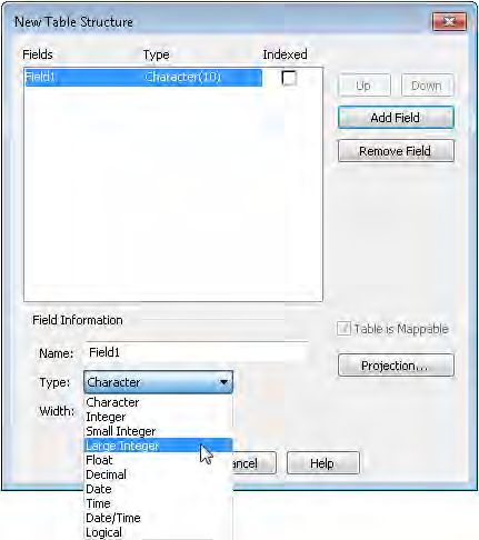
Large Integer Variables and Fields
In addition to the MapBasic integer and field types SmallInt and Integer, MapInfo Pro now has a
type for storing 64-bit (8 byte) integers called LargeInt.
Name Description
SmallInt Whole numbers from -32768 to 32767 (inclusive); stored in 2 bytes.
Integer Whole numbers from -2,147,483,648 to +2,147,483,647 (inclusive); stored in 4
bytes.
LargeInt Whole numbers from –9,223,372,036,854,775,808 to
+9,223,372,036,854,775,807 (inclusive); stored in 8 bytes.
LargeInt variables and fields can store all numbers within the limits mentioned above. However,
some operations that convert integers to floating-point numbers can result in a loss of precision,
because floating-point numbers can store fewer significant digits than a 64-bit integer. Thematic
maps are an example of such an operation. If you create thematic maps using LargeInt values that
MapInfo Pro 16.0.4 Release Notes 20MapInfo Pro 16.0.4 Release Notes
exceed approximately ±9 quadrillion (9 followed by 15 zeros), then the thematic bins may not be
correct.
In the dialogs for creating new tables and modifying a table’s structure, you can select this type by
choosing Large Integer. The following is an example of this. To can see the following dialog, on the
TABLE tab click New Table and then select the Create button in the New Table dialog box.
Overriding the Coordinate Order for OGC Web Services
After creating a Web Feature Service (WFS), Web Map Service (WMS), or Web Map Tile Service
(WMTS) table, the map image might not display or might be in the wrong location and distorted due
to the coordinate order in use by the server. Coordinate values are listed in the axis order as specified
by the referenced coordinate reference system (CRS). However, not all servers follow the Open
Geospatial Consortium (OGC) Interface Standard. As a result, coordinates for coordinate systems,
such as latitude/longitude systems, may be in reverse order from what is expected when retrieving
or saving tables using one of these OGC services. If after creating a table, the map image does not
display or is in the wrong location and distorted, then you may need to override the coordinate order.
Prior to this release, if you wanted to override the coordinate order for all tables created using a
server, it was necessary to manually edit the server XML file for that server. There is now a check
box called Override Coordinate Order in the Server Information dialog box, so that editing the XML
manually is no longer necessary. Select this check box when the data from a server is distorted or
in the wrong location.
MapInfo Pro 16.0.4 Release Notes 21MapInfo Pro 16.0.4 Release Notes
To see the Server Information dialog box to select to override coordinate order for all tables created
from a server:
1. On the HOME tab, select Open, and then Mapping (WMS) or Feature (WFS) or Mapping (WMTS),
Mapping (WMS).
2. On the dialog that opens, click Servers.
3. On the Servers List dialog that opens, select the server you want to work with and then click
Edit.
4. To override the coordinate order for all tables created using this server, select the Override
Coordinate Order check box.
If you have previously edited the server XML file manually to add the override for a server, then the
Override Coordinate Order check box is enabled for that server. If you change the setting for a
server, then that setting only applies to new tables created using that server.
New Coordinate Ellipsoid Definitions
There are two new ellipsoid definitions in this maintenance release: GSK-2011 and PZ-90.11.
Ellipsoid # Ellipsoid Name Major Semi Axis Inverse Flattening 1/f
56 GSK-2011 6378136.5 298.2564151
57 PZ-90.11 6378136.0 298.25784
To create custom datums using these new ellipsoid definitions, see the following references for the
valid datum parameters:
• GSK-2011
https://www.fig.net/resources/proceedings/fig_proceedings/fig2015/ppt/ts02g/TS02G_karpik_gienko_7538_ppt.pdf
• PZ-90.11
http://geophy.uni.lu/users/tonie.vandam/REFAG2014/SESS_IV_Reg_Ref_Frames/Tatevian.pdf
Using one of these ellipsoids in a TAB, MIF, or WOR (workspace) file upgrades the file to version
1501.
MapInfo Pro 15.2.x and 16.0 cannot correctly use tables containing these new ellipsoid definitions.
When you open such a table in MapInfo Pro 15.2.x or 16.0, the CoordSys of the table is set to
WGS84. Opening a workspace in 15.2.x or 16.0 that uses the Set Map CoordSys statement with
one of these ellipsoids definitions generates an error. When you dismiss the error, MapInfo Pro use
WGS84 for table's CoordSys. The same error displays from an MBX or MapBasic window and when
importing a MIF file that uses one of these new ellipsoids in a Coordsys clause.
MapInfo Pro 16.0.4 Release Notes 22MapInfo Pro 16.0.4 Release Notes
Additions to MapInfo Pro Extensibility Framework
Following changes have been made to the MapInfo Pro Extensibility Framework:
• Added a new event "MapInfoProExiting", which is called just before exiting MapInfo Pro application.
This event is fired before MapInfo Pro starts exiting, and gives a chance to the addins to cancel
the exit of MapInfo Pro. Add-In should not write any clean-up code in the handler of this event.
Unload event handle in addin should be used for clean-up purpose which is fired when MapInfo
Pro is actually exiting.
• Icons to the controls in addins can now also be loaded from custom resource assemblies using
the below format:
• To load images from custom resource assemblies, specify the pack URI with below format:
"pack://addinorigin:,,,/{absolute path to resource
assembly};component/{location of image in assembly with image name}"
Example: "pack://addinorigin:,,,/D:/folder/CustomResource.dll;component/Images/testImage.png"
• To load an in-built MapInfo Pro image, specify the pack URI with below format:
"pack://application:,,,/MapInfo.StyleResources;component/Images/{location
of image with image name}"
Example:
"pack://application:,,,/MapInfo.StyleResources;component/Images/Raster/rasterTools_16x16.png"
New MapInfo Advanced Features
Sample Count for Line Of Sight
MapInfo Pro Advanced lets you create points where the Line of Sight intersects raster cells. You
can control the number of points that display by setting the sample count. When you select the
Specify Sample Count check box, the Maximum Sample Count field displays the default number of
points, which you can change to a smaller value. The default value is the maximum number of points
allowed; if you enter a higher value, points will not be created beyond the maximum allowed.
Intervisibility for Viewshed
MapInfo Pro Advanced now includes a Compute Intervisibility feature in the Viewshed dialog that
calculates points falling in the direct line-of-sight from an observer's point in the viewing radius.
Intervisibility plays a major role in terrain analysis and is useful for determining how many towers
are visible from a point in the viewing radius.
When analyzing a viewshed with Multiple Points (.TAB) files, check the Compute Intervisibility check
box. This ensures that all the cells in the output file will have the number of points from Multiple
Points (.TAB) file that are visible from the cell.
MapInfo Pro 16.0.4 Release Notes 23MapInfo Pro 16.0.4 Release Notes
MapBasic Updates
The MapBasic StringByteLength() function returns the number of bytes in a string for a given character
set (charset). Previously, if no value was passed for charset, then the number of bytes were returned
using the system charset. Now when no value is passed for charset, this function returns an error.
Progress and Resolution of Outstanding Issues
This release resolves the following outstanding issues.
MapInfo Pro
Issue Number Description and Resolution
MIPRO-30239 The Web Map Service (MWS) writing from MapInfo Pro should not include the full path for file-based
data sources.
Resolution: Fixed.
MIPRO-36633 The Snap and Thin commands fill holes when they should not. This issue occurs when data has
very tiny holes. A similar issue also exists using the Clean and Erasecommands.
Resolution: Fixed.
MIPRO-38167 When changing the font size in a Browser window and then use Pick Fields, the font size may not
be save correctly in a workspace (*.wor).
Resolution: Fixed.
MIPRO-43569 Cannot change the object style of the points in an Access ODBC table.
Resolution: Fixed.
MIPRO-49930 I am losing labels on polygons when zooming out of a map.
This happens when you use the label option to auto position labels within a region with the option
to place outside if necessary (a callout).
Resolution: Fixed. You may now see labels when you are zoomed farther out of the map and the
reference object is at a smaller size.
MIPRO-60932 Custom range fill and/or border color changes do not take effect at the same time, so that I must
redo the border color.
Resolution: Fixed.
MapInfo Pro 16.0.4 Release Notes 24MapInfo Pro 16.0.4 Release Notes
Issue Number Description and Resolution
MIPRO-71906 Copying data from one table to another creates a pending edit on the original table.
Resolution: Fixed.
MIPRO-75160 This operation cannot be completed, because the instance is not valid. Use MakeValid to convert
the instance to a valid instance.
Resolution: Fixed.
MIPRO-75344 Dragging and dropping multiple tab files causes them to open in separate Map windows instead of
one window.
Resolution: Fixed. Tab files now open into the Table list instead of into a Map window.
MIPRO-75520 The Erase Outside Polygon command causes MapInfo Pro 15.2 to close unexpectedly.
Resolution: Fixed.
MIPRO-75555 In MapInfo Pro 15.2, zooming in on a layout does not refresh the Map frame.
Resolution: Fixed.
MIPRO-75922 MapInfo Pro closes unexpectedly for the Create Query From statement in version 12.5 and higher.
This issue occurs when creating a query from a browser that has had columns removed.
Resolution: Fixed.
MIPRO-76593 Tab switching occurs even after turning it off.
When switching back and forth between windows, such as the Browser or Map windows, the
corresponding ribbon tab also switches. This continues to happen even after turning it off on the
PRO tab, by selecting Options, Application, and then setting Set Tab Switching to None.
Resolution: Fixed.
MIPRO-76923 Printing a map to Layered PDF when the map contains a bivariate theme causes an issue. The layer
that is only applying the color is not properly handled.
Resolution: Fixed. The Layered PDF file includes the base layer in the PDF layer list. If you do not
want to see it, toggle the layer visibility off in the PDF file.
MIPRO-78626 I am unable to split a polyline at the selected node on the cosmetic layer.
Resolution: Fixed.
MapInfo Pro 16.0.4 Release Notes 25MapInfo Pro 16.0.4 Release Notes
Issue Number Description and Resolution
MIPRO-79730 MapInfo Pro may close unexpectedly when moving labels in a map frame in the Layout window.
This issue is related to MIPRO-86142 and to MIPRO-80615
Resolution: Fixed.
MIPRO-80615 Pro freezes or closes unexpectedly when splitting nodes in a workspace that is active in a Map
window.
This issue is related to MIPRO-79730 and to MIPRO-86142.
Resolution: Fixed.
MIPRO-80696 The arrow keys on the keyboard zoom the active Map window instead of scrolling it.
Resolution: Fixed.
MIPRO-81655 The behavior of the Copy and Paste commands is not consistent with 32-bit versions of MapInfo
Pro.
In 64-bit versions of MapInfo Pro, the Copy and Paste commands target the current, active, window.
As a result, the Paste command works on the Layer Control or Explorer windows when they are
active.
Resolution: Fixed. After selecting a layer in a Layer Control or Explorer window and focus is not
on a text box, the Paste command works on the front document window. This makes the behavior
consistent with 32-bit versions of MapInfo Pro.
MIPRO-81831 Label MAX token should be ignored or re-added to alter the maximum number of labels set in old
workspaces (*.wor files).
Resolution: Fixed. The Set Map Layer ID Label Max statement is now ignored and does nothing.
MIPRO-82707 Large workspaces with many floating windows become unusable when the Explorer window is
open.
Large workspaces may experience slower object selection due to a performance issue in the Table
list. This is especially noticeable when a workspace is open. When the Explorer window is closed
there is no issue.
Resolution: Fixed.
MIPRO-83639 Visual Basic stops working when connecting to MapInfo 15.2 (64-bit). The progress dialog stops
working when invoked from within an integrated mapping application.
Resolution: Fixed. The 64-bit progress dialog has been turned off for custom integrated mapping
applications.
MapInfo Pro 16.0.4 Release Notes 26MapInfo Pro 16.0.4 Release Notes
Issue Number Description and Resolution
MIPRO-84176 Map rendering is four times slower in version 15.2 compared to 12.5.
An issue was introduced in version 15.2 that affects performance when labeling layers with line
geometries as well as region and/or point geometries.
Resolution: Fixed in all versions of 16.0 except for English. Fixed in for English in this 16.0.1
maintenance release.
MIPRO-84274 The Statistics window has a performance issue.
There is a performance issue when the Statistics window is open while updating object styles for
a selection in a Map window.
Resolution: Fixed.
MIPRO-84687 The layout frame name sometimes disappears when pasting.
Pasting a Layout Designer frame into a page other than page 1 deletes the frame name, such as
when pasting empty frames with a default frame name.
Resolution: Fixed.
MIPRO-85699 The Layout Frame Properties dialog should show the current style on the style button.
Currently the Layout Frame Properties shows a black and white region sample regardless of the
frame style.
Resolution: Fixed. The Layout Frame Properties dialog now shows the current style on the style
picker button.
MIPRO-86141 Exporting to DBF has fewer choices for file character sets.
Resolution: Fixed. We have reinstated the DOS characters sets as choices when importing, exporting,
and registering tables.
MIPRO-86142 MapInfo Pro closes unexpectedly when working with labels in a Map window.
This issue is related to MIPRO-79730 and to MIPRO-80615.
Resolution: Fixed.
MIPRO-86526 The Web Map Tile Service (WMTS) returns an error for the NZTM projection.
Resolution: Fixed.
MIPRO-86651 When accessing a Tile server MapInfo Pro generates an error without prompting for credentials.
Resolution: Fixed. MapInfo Pro now prompts for credentials when a Tile server requires authentication.
MapInfo Pro 16.0.4 Release Notes 27MapInfo Pro 16.0.4 Release Notes
Issue Number Description and Resolution
MIPRO-86686 Registering a Geocoding server fails with an error message.
A failure occurs when you do not register the server on MapInfo Pro's backstage.
Resolution: Fixed. Registration no longer fails even if it is done via the Geocoding or Find Address
commands.
MIPRO-86695 A hidden layer stays hidden even after I click the Editable icon to make it editable.
Resolution: Fixed.
MIPRO-86794 Exporting to MIF is twice as slow since version 15.2.
Resolution: Fixed. Exporting to MIF and/or MID is now faster.
MIPRO-86809 The Universal Translator does not support JGD2011.
Resolution: Fixed.
MIPRO-87176 An error occurs when using WFS-T in MapInfo Pro 15.0 and 16.0.
Resolution: Fixed. Improvements have been made to how XML Namespace is handled for WFS-T.
MIPRO-87233 I cannot enter a distributed serial key in the Runtime License Activation dialog. This happens after
the distributed license is transferred to the License Server Utility and then restarting MapInfo Runtime.
Resolution: Fixed.
MIPRO-87283 When using the Redistricter, the fill field (fill pattern colors) is empty.
Resolution: Fixed.
MIPRO-87326 Using EasyLoader 16.0 from MapInfo Pro 16.0 (64-bit) to upload tables into SQL Server Spatial,
uploads geometry instead of geography.
Resolution: Fixed.
MIPRO-87331 The Layout Designer scale bar spelling should be "metres" for UK English installations.
Resolution: Fixed. The strings used for unit names in the Layout Designer scale bar now come
directly from MapInfo Pro resources and not separate Layout Designer scale bar resources. This
affects all languages, not just UK English.
MapInfo Pro 16.0.4 Release Notes 28MapInfo Pro 16.0.4 Release Notes
Issue Number Description and Resolution
MIPRO-87516 There is a performance issue when using MapCAD's SplitToLines feature and updating a Browser
window.
Updates to tables, such as object processing, inserts, or updating columns, take much longer when
document windows, such as Map, Browser, or Layout windows, are open versus when they are
closed.
Resolution: Fixed.
MIPRO-87611 The Pack Table command no longer gives the option to save to a workspace (*.WOR) before packing
a table.
Resolution: Fixed.
MIPRO-87628 The Do not use list in the proxy settings does not stick.
Resolution: Fixed.
MIPRO-88231 MapInfo Pro closes unexpectedly when opening a Shape file in the MapInfo Pro default coordinate
system (CoordSys), which is Lon\Lat (WGS84).
The Shape file is set in an unknown projection, uses meters, and has several million square regions.
MapInfo Pro builds a MAP file when it opens the Shape file (SHP). By default the MAP file uses a
16K block size for Shape files and then grows exponentially when creating coincident objects. This
issue occurs when the MAP file exceeds the 2GB size limit for a Native (TAB) table. For a projection
system such as Mercator, the MAP file would not contain as many of these 16K blocks, so the issue
would not occur.
Resolution: Fixed. MapInfo Pro now displays an error when opening a file that exceeds the 2GB
size limitation for a Native (TAB) table. MapInfo Pro closes and de-registers the table when this
happens.
MapInfo Pro Advanced
MapInfo Pro Advanced is an extension that installs with MapInfo Pro to work with raster files that
contain grid-based spatial information.
Issue Number Description and Resolution
MIRCS-85 The Contour operations generates an incorrect projection. The output file is always in a non-Earth
projection regardless of the input file projection.
Resolution: Fixed.
MIRCS-88 See MIRCS-85
Resolution: Fixed.
MapInfo Pro 16.0.4 Release Notes 29MapInfo Pro 16.0.4 Release Notes
Issue Number Description and Resolution
MIRCS-92 When MapInfo Pro Advanced exports a GeoSoft (.grd) file to a .TAB file it displays an error, "Failed
to set Table Meta Data".
Resolution: Fixed.
MIRCS-100 See MIRCS-85
Resolution: Fixed.
MIRCS-116 MapInfo Pro Advanced stops responding after selecting Cell Value and All and then clicking on a
cell. This happens while using the GELink tool with multiple open map windows.
Resolution: Fixed. The cell value tool now gives the correct information.
MIRCS-120 On the Advanced Color dialog, selecting the BreakTable option to add breaks for zero data range
causes MapInfo Pro Advanced to close unexpectedly.
Resolution: Fixed. Now, Insert Row will be disabled if UpperBandPassLimit and LowerBandPassLimit
are same, which means if the source raster is a contant raster whose data range is zero, the Insert
Row button will be in the disabled state.
MIRCS-121 When using the Merge or Resample tools, a multiband raster data does not get the correct band
values.
Resolution: Fixed.
MIRCS-126 The Create Raster tool shows the tool tip twice for the Select Columns command.
Resolution: Fixed.
MIRCS-137 The result of a Contour (Region) operation for Fixed Interval with a single row is incorrect.
Resolution: Fixed. The minimum value is now correctly applied.
MapBasic
MapBasic is the programming language that lets you customize and automate MapInfo Pro.
Issue Number Description and Resolution
MIPRO-79376 There is a MapBasic application error when running MapInfo Pro 15.0 generating the message,
"Unable to translate the Spatial Constraint".
MapInfoPro is not creating a proper spatial Where clause in one of the Oracle statements.
MapInfo Pro 16.0.4 Release Notes 30MapInfo Pro 16.0.4 Release Notes
Issue Number Description and Resolution
Resolution: Fixed.
MIPRO-81672 The Buffer function seems to have a memory leak.
MapInfoPro is not cleaning up memory when using the MapBasic Buffer function.
Resolution: Fixed.
MIPRO-82907 Cannot re-add a legend frame that was removed using an MBX in versions 15.0, 15.2, and 16.0.
A legend frame cannot be added back to a layout if it was removed using the MapBasic statement
Remove Designer Frame Id.
Resolution: Fixed.
MapInfo Pro 16.0.4 Release Notes 31pitney bowes 0. 3001 Summer Street Stamford CT 06926-0700 USA www.pitneybowes.com © 2018 Pitney Bowes Software Inc. All rights reserved
You can also read