Remote Sensing of Savannas and Woodlands: Editorial - MDPI
←
→
Page content transcription
If your browser does not render page correctly, please read the page content below
remote sensing
Editorial
Remote Sensing of Savannas and Woodlands: Editorial
Michael J. Hill

                                          Department of Earth System Science and Policy, University of North Dakota, Grand Forks, ND 58202, USA;
                                          michael.hill4@und.edu

                                          1. Background
                                                Savannas and woodlands represent one of the most challenging targets for remote
                                          sensing. They provide a complex gradient of woody and herbaceous plant species that
                                          varies widely in spatial arrangement, plant density and height, and canopy persistence
                                          (evergreen to deciduous) of the woody plant component. The understory component also
                                          varies from annual to perennial grassland, and pure grassland to a complex mix of grasses,
                                          forbs, palms, cycads and small shrubs. Savannas and woodlands are geographically
                                          associated with grasslands, shrublands and dry forests at their dry margins, and temperate
                                          and tropical forests at the wet margins. Savannas are generally regarded as an intermediate
                                          state between grassland and forest maintained by herbivory and wildfire and influenced
                                          by climatic and edaphic characteristics.
                                                The grasslands, savannas and woodlands of sub-Saharan Africa played a key role
                                          in development of the remote sensing of vegetation cover and dynamics [1–7]. This
                                          vegetation provided a fertile target for the earliest applications of the Normalized Difference
                                          Vegetation Index (NDVI) and introduced the public to large-scale regional dynamics of
                                          climate-driven vegetation growth. Although there is wide geographical variation in the
                                          density and seasonality of woody canopies, savannas and woodlands are associated with
                                          highly seasonal climates, and the pattern of vegetation greening and browning detected by
                                space-borne sensors is largely driven by the behavior of the understory. Despite this, much

                                          of the attention on remote sensing of savannas and woodlands has historically focused on
Citation: Hill, M.J. Remote Sensing
                                          the woody component.
of Savannas and Woodlands:
                                                Since the 1980s, savannas and woodlands have continued to be at the forefront of
Editorial. Remote Sens. 2021, 13, 1490.
                                          developments in remote sensing. Savannas and woodlands were the target for international
https://doi.org/10.3390/rs13081490
                                          projects aimed at understanding ecosystem behavior such as the Hydrological Atmospheric
                                          Pilot Experiment (HAPEX) Sahel [8], the Southern Africa Regional Science Initiative (SA-
Received: 6 April 2021
Accepted: 12 April 2021
                                          FARI 2000) [9] and continued studies along the Northern Australian Tropical Transect [10],
Published: 13 April 2021
                                          all of which have included major remote sensing components especially utilizing the Ad-
                                          vanced Very High Resolution Radiometer (AVHRR) and the MODerate resolution Imaging
Publisher’s Note: MDPI stays neutral
                                          Spectroradiometer (MODIS). African savannas have played an important role in assessing
with regard to jurisdictional claims in
                                          the potential of radar backscatter for retrieval of, for example, herbaceous biomass with
published maps and institutional affil-   the European Remote sensing Satellite (ERS) wind scatterometer [11] and woody biomass
iations.                                  with the Advanced Land Observing Satellite Phased Array L-band Synthetic Aperture
                                          Radar (ALOS PALSAR) [12]. Since wildfire is such an important feature of savannas,
                                          these ecosystems have been, and continue to be, at the forefront of the development of
                                          fire products such as hotspots and burned areas [13]. In the absence of a satellite-based
Copyright: © 2021 by the author.
                                          imaging spectrometer with a high signal-to-noise ratio, especially in the short-wave in-
Licensee MDPI, Basel, Switzerland.
                                          frared range, airborne spectrometers alone and in association with full-waveform lidar
This article is an open access article
                                          have been used to characterize the biochemistry [14], floristics [15], structure [16,17] and
distributed under the terms and           species composition [18] of savannas at the landscape scale.
conditions of the Creative Commons              Savannas and woodlands, especially in Africa and South America, deserve increased
Attribution (CC BY) license (https://     attention for remote sensing studies since they are prime candidates for agricultural con-
creativecommons.org/licenses/by/          version, important resources for livestock production and subsistence of indigenous com-
4.0/).                                    munities, and could play a significant role in signaling vegetation shifts driven by the

Remote Sens. 2021, 13, 1490. https://doi.org/10.3390/rs13081490                                     https://www.mdpi.com/journal/remotesensing
Remote Sens. 2021, 13, 1490 2 of 6
interaction of climate change and rising atmospheric CO2 concentrations. This Special
Issue sought to provide an overview of the application of the latest sensors and sensor
combinations to retrieval of quantitative properties of savannas and woodlands. It was
hoped that contributions would illustrate improvements in retrievals of attributes of cover
components and component dynamics and relate these attributes to the wide diversity of
issues faced by savanna and woodland systems globally.
2. The Papers
The papers provide a very current perspective on remote sensing of savannas and
woodlands and reflect both methodological trends, and geographical imperatives driven
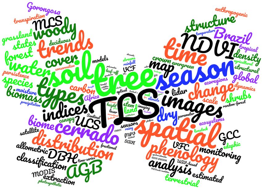
by threats. An analysis of word frequency in the abstracts from the 12 papers, using
Wordclouds.com, revealed several specific points of focus (Figure 1). The word cloud is
presented with six types of words. The most common “ecosystem” words were tree, soil
and water. Grassland, forest and species were present but less common in keeping with
a continued emphasis on the woody component of savannas and woodlands. Among
“climate-related” words, season and dry were most common matching the broad climatic
characteristics of savannas and woodlands involving distinct periods of growth, senes-
cence and dormancy. Among the “process” words, spatial, trends, phenology, distribution,
change and time were most common reflecting interest in the arrangement of vegetation,
the interaction of climate and growth pattern and the driving forces affecting savannas
and woodlands. The “method” words were dominated by terrestrial laser scanning (TLS)
and related acronyms (ULS—unmanned aerial vehicle laser scanning; MLS—mobile laser
scanning), and by NDVI and indices, indicating the legacy of those initial remote sensing
studies discussed above and the enduring value of the NDVI. More generic words such
as sensor, images, mapping, analysis, area, difference, scale and monitoring were also common.
The papers also used an array of space-borne sensor systems including Landsat, MODIS
(various products), Sentinel 1, Sentinel 2, ALOS PALSAR and Compact High Resolution
Imaging Spectrometer (CHRIS). Several studies used combinations of sensor types includ-
ing optical, SAR and LiDAR. The “geography” words were dominated by cerrado and
Brazil with biome and global next most common. However, the 11 research papers provide a
relatively balanced coverage of savanna and woodland geography, with four articles on
South America, two articles on Africa, two articles on Australia, one each on North America
and Europe, and one article with global coverage. Finally, the “attribute’ words included
types, structure, AGB, biomass, woody, and density reflecting the fundamental characteristics
of savannas and woodlands that need to be measured and that make them a complex target
for remote sensing.
The Special Issue is nicely balanced in terms of geography and technology. It has
two feature topics: the Cerrado and bordering ecosystems; and laser scanning as the
technology of the moment for characterizing savanna vegetation structure. The Special
Issue is conceptually organized in the first instance by geography. The lead article [19]
covers the global extent of grasslands and savannas using the MODIS sensor and provides
global geographical context. This is followed by the feature review on TLS in savannas [20].
The articles then follow global geography starting in the southern hemisphere dealing
with TLS in the Australian tropical savanna [21,22]. Next come four articles on various
aspects of savanna and woodland vegetation in Brazil [23–26]. These are followed by
two articles on African environments that include a mix of savannas and woodlands
and other vegetation [27,28]. The final two articles address functional ecological aspects
of two different types of northern hemisphere oak savannas in North America [29] and
Europe [30].Remote
Remote Sens. 2021, 13,
Sens. 2021, 13, x1490
FOR PEER REVIEW 33 of 6
Figure 1. Word cloud based on the article abstracts (two occurrences or more). The terms savanna,
Figure 1. savanna, woodland,
woodland, remote
remote and
sensing
sensing are
are excluded
excludedsince
sincethey
theyare
arethe
thetopic
topicofof
thethe
Special Issue.
Special Words
Issue. represent
Words all versions
represent of the
all versions of term or concept,
the term e.g.,
or concept,
season includes
e.g., season seasonal
includes andand
seasonal seasonality.
seasonality.Only place
Only placenames
names and
andacronyms
acronymsareare capitalized.
capitalized. Color
Color scheme:
scheme: light
light
green—ecosystem
green—ecosystem words;words; blue—climate
blue—climate -related
-related words;
words; red—process
red—process words;
words; black—method
black—method words;
words; purple—geography
purple—geography
words; and dark green—vegetation attribute words. Word cloud produced on http://wordclouds.com.(accessed
words; and dark green—vegetation attribute words. Word cloud produced on http://wordclouds.com (accessed on 6 April on 6
April 2021).
2021).
The
The group
group of of four
fourpapers
paperson onSouth
SouthAmerica
America span
span thethe ecotone
ecotone fromfrom
the the heavily
heavily al-
altered
tered
Mato Mato
GrossoGrosso
forestsforests in Amazonia
in Amazonia throughthrough the savanna
the savanna of the Cerrado
of the Cerrado to the drytoforests
the dryof
forests of the These
the Caatinga. Caatinga. These
papers papers
explore the explore
mappingthe of mapping
vegetationoftypes
vegetation
[23], thetypes [23], the
measurement
measurement of woody above-ground
of woody above-ground biomass (AGB) biomass (AGB)
[24], the [24], the
long-term long-term
change changevegeta-
in savanna in sa-
tion [25] and water use [26]. The emphasis on this continuum
vanna vegetation [25] and water use [26]. The emphasis on this continuum from from tropical rainforest
tropical
through savanna
rainforest throughtosavanna
dry forest is timely
to dry forestand important
is timely as this environment
and important is subject to
as this environment is
massive anthropogenic change and complex political forces within
subject to massive anthropogenic change and complex political forces within Brazil Brazil that influence
that
the balance
influence thebetween
balanceconservation and exploitation
between conservation of these ecosystems.
and exploitation The paper byThe
of these ecosystems. de
Souzaby
paper Mendes
de Souza[23]Mendes
uses multiple
[23] uses satellite
multiplesources of SAR
satellite imagery
sources of SAR with Sentinel
imagery with 2 Sen-
data
to distinguish among forest and woody savanna types in the Cerrado.
tinel 2 data to distinguish among forest and woody savanna types in the Cerrado. The The paper by
Bispo et al. [24] combines airborne LiDAR with Landsat 8 and ALOS
paper by Bispo et al. [24] combines airborne LiDAR with Landsat 8 and ALOS PALSAR PALSAR to map AGB
for a catchment-scale study region of the Cerrado. The paper by Paloschi et al. [26] reports
to map AGB for a catchment-scale study region of the Cerrado. The paper by Paloschi et
on the strong dependence of water use on soil moisture, and the variation in phenology,
al. [26] reports on the strong dependence of water use on soil moisture, and the variation
and physiology of individual species in this dry, fragile Caatinga environment. The paper
in phenology, and physiology of individual species in this dry, fragile Caatinga envi-
by Alencar et al. [25] is a new and significant documenting of long-term change in natural
ronment. The paper by Alencar et al. [25] is a new and significant documenting of
native vegetation in the Cerrado using 33 years of Landsat imagery in the Google Earth
long-term change in natural native vegetation in the Cerrado using 33 years of Landsat
Engine. This is already the most viewed and cited article in this Special Issue.
imagery in the Google Earth Engine. This is already the most viewed and cited article in
The review of the application of TLS with a focus on savannas [20] and the two papers
this Special Issue.
focused on the application of TLS in savannas and woodlands of Northern Australia [21,22]Remote Sens. 2021, 13, 1490 4 of 6
form the second feature topic. The review [20] and the article by Levick et al. [22] are com-
plementary in that the former identifies both the value of TLS in savannas, and the limited
application and potential issues, whilst the latter explicitly answers issues surrounding
the spatial extent and structural complexity by demonstrating the value of combining
TLS, ULS and MLS. Both articles are important contributions to the literature and to the
application of laser scanning in savannas and woodlands. The paper by Luck et al. [21]
provides an example of retrieval of savanna structure using TLS and an explicit description
of a northern Australian savanna in the wet tropical zone.
The article by Hill and Guerschman [19] describes the MODIS Global Vegetation
Cover Product and characterizes trends in vegetation cover fractions between 2001 and
2018 across global savannas and woodlands as well as associated grasslands. The study
documents trends in non-photosynthetic (dry or brown) vegetation for the first time and
identifies grasslands and savannas with concerning positive trends in the bare soil fraction.
The two articles based in Africa explore aspects of savanna and woodland vegetation
structure and temporal persistence using MODIS data. Kumar et al. [27] examine apparent
differences in spatial structure of woody vegetation across sub-Saharan Africa retrieved
from different MODIS products. They suggest that multimodal spatial structure is region-
ally disaggregated, and that apparent spatial structure retrieved may be dependent upon
the remote sensing product and spatial scale of retrievals. Herrero et al. [28] provide a
temporal study of the Gorongosa National Park in Mozambique which explores the persis-
tence of the MODIS NDVI signal in relation to changes in precipitation in the period since
the year 2000. The study reveals a decline in vegetation as measured by NDVI persistence
especially in grassland and rainforests potentially associated with declining precipitation.
Oak savannas were once much more common in temperate ecosystems forming an
ecotone between grassland and forests. The two articles published here represent two major
types: the perennial grass/oak savannas that stretched from southern Canada to northern
Mexico between the grasslands and forests of North America; and the annual grass/oak
savannas found, for example, in California and Spain. The paper by Hill et al. [29] describes
the use of a rare time series from the CHRIS hyperspectral sensor to explore functional
phenology of the woody canopy in a conserved but degraded post oak savanna in Texas
invaded with evergreen shrubs. The results of this study hint at the value of hyperspectral
data in characterization of differences in canopy properties and species mixtures that
are important in the evolution of disturbed remnant landscapes. However, they also
emphasis the limitations of 20-year-old low signal-to-noise imaging spectrometer data, and
the gaping chasm in the capability of satellite remote sensing for quantitative retrievals
of vegetation canopy biochemistry waiting to be occupied by a state-of-the-art imaging
spectrometer. By contrast, Gómez-Giráldez et al. [30], examine the phenology of the tree
and understory layers in relation to soil water dynamics in an annual grass/oak savanna in
Spain using a Sentinel 2 time series. The study showed a high degree of synchrony between
NDVI and soil moisture. However, some vegetation indices were potentially sensitive to
subtle variations in chlorophyll content of the understory grassland.
The featured emphasis on TLS [20–22] and the Cerrado [23–26] points to the technol-
ogy currently at the cutting edge for remote measurement, and to the focus of concern for
the fate of carbon stocks and biodiversity in one of the largest savannas in the world. The
adoption of Sentinel 2 [23,30], the application of big-data processing [25] and the combina-
tion of SAR, LiDAR and optical data [23,24] signal the future direction of remote sensing of
savannas from space. Multi-sensor imaging and multi-scale laser scanning are necessary to
truly capture the three-dimensional properties of savannas and woodlands. It notable that
only two papers were focused on the understory grassland [19,30]. Nevertheless, there is
still a role for polar orbiting medium resolution sensors [19,27,28] and a pressing need for
a for a modern imaging spectrometer in orbit.
Funding: This research received no external funding.Remote Sens. 2021, 13, 1490 5 of 6
Acknowledgments: I wish to all thank authors for submitting to the Special Issue and for contributing
to what is a distinctive perspective on the current state of remote sensing of savannas and woodlands.
Conflicts of Interest: The author declares no conflict of interest.
References
1. Tucker, C.; Vanpraet, C.; Sharman, M.; Van Ittersum, G. Satellite remote sensing of total herbaceous biomass production in the
senegalese sahel: 1980–1984. Remote Sens. Environ. 1985, 17, 233–249. [CrossRef]
2. Tucker, C.J.; Townshend, J.R.; Goff, T.E. African Land-Cover Classification Using Satellite Data. Science 1985, 227, 369–375.
[CrossRef]
3. Tucker, C.J.; Justice, C.O.; Prince, S.D. Monitoring the grasslands of the Sahel 1984–1985. Int. J. Remote Sens. 1986, 7, 1571–1581.
[CrossRef]
4. Justice, C.O.; Hiernaux, P.H.Y. Monitoring the grasslands of the Sahel using NOAA AVHRR data: Niger 1983. Int. J. Remote Sens.
1986, 7, 1475–1497. [CrossRef]
5. Justice, C.O.; Holben, B.N.; Gwynne, M.D. Monitoring East African vegetation using AVHRR data. Int. J. Remote Sens. 1986, 7,
1453–1474. [CrossRef]
6. Prince, S.D.; Tucker, C.J. Satellite remote sensing of rangelands in Botswana II. NOAA AVHRR and herbaceous vegetation. Int. J.
Remote Sens. 1986, 7, 1555–1570. [CrossRef]
7. Townshend, J.R.G.; Justice, C.O. Analysis of the dynamics of African vegetation using the normalized difference vegetation index.
Int. J. Remote Sens. 1986, 7, 1435–1445. [CrossRef]
8. Prince, S.; Kerr, Y.; Goutorbe, J.P.; Lebel, T.; Tinga, A.; Bessemoulin, P.; Brouwer, J.; Dolman, A.; Engman, E.; Gash, J.; et al.
Geographical, biological and remote sensing aspects of the hydrologic atmospheric pilot experiment in the sahel (HAPEX-Sahel).
Remote Sens. Environ. 1995, 51, 215–234. [CrossRef]
9. Privette, J.L.; Roy, D.P. Southern Africa as a remote sensing test bed: The SAFARI 2000 Special Issue overview. Int. J. Remote Sens.
2005, 26, 4141–4158. [CrossRef]
10. Ma, X.; Huete, A.; Moore, C.E.; Cleverly, J.; Hutley, L.B.; Beringer, J.; Leng, S.; Xie, Z.; Yu, Q.; Eamus, D. Spatiotemporal
partitioning of savanna plant functional type productivity along NATT. Remote Sens. Environ. 2020, 246, 111855. [CrossRef]
11. Jarlan, L.; Mougin, E.; Frison, P.; Mazzega, P.; Hiernaux, P. Analysis of ERS wind scatterometer time series over Sahel (Mali).
Remote Sens. Environ. 2002, 81, 404–415. [CrossRef]
12. Mitchard, E.T.A.; Saatchi, S.S.; Woodhouse, I.H.; Nangendo, G.; Ribeiro, N.S.; Williams, M.; Ryan, C.M.; Lewis, S.L.;
Feldpausch, T.R.; Meir, P. Using satellite radar backscatter to predict above-ground woody biomass: A consistent relationship
across four different African landscapes. Geophys. Res. Lett. 2009, 36. [CrossRef]
13. Campagnolo, M.; Libonati, R.; Rodrigues, J.; Pereira, J. A comprehensive characterization of MODIS daily burned area mapping
accuracy across fire sizes in tropical savannas. Remote Sens. Environ. 2021, 252, 112115. [CrossRef]
14. Knox, N.M.; Skidmore, A.K.; Prins, H.H.; Asner, G.P.; van der Werff, H.M.; de Boer, W.F.; van der Waal, C.; de Knegt, H.J.;
Kohi, E.M.; Slotow, R.; et al. Dry season mapping of savanna forage quality, using the hyperspectral Carnegie Airborne
Observatory sensor. Remote Sens. Environ. 2011, 115, 1478–1488. [CrossRef]
15. Landmann, T.; Piiroinen, R.; Makori, D.M.; Abdel-Rahman, E.M.; Makau, S.; Pellikka, P.; Raina, S.K. Application of hyperspectral
remote sensing for flower mapping in African savannas. Remote Sens. Environ. 2015, 166, 50–60. [CrossRef]
16. Chen, Q.; Baldocchi, D.; Gong, P.; Kelly, M. Isolating Individual Trees in a Savanna Woodland Using Small Footprint Lidar Data.
Photogramm. Eng. Remote Sens. 2006, 72, 923–932. [CrossRef]
17. Asner, G.P.; Levick, S.R.; Kennedy-Bowdoin, T.; Knapp, D.E.; Emerson, R.; Jacobson, J.; Colgan, M.S.; Martin, R.E. Large-scale
impacts of herbivores on the structural diversity of African savannas. Proc. Natl. Acad. Sci. USA 2009, 106, 4947–4952. [CrossRef]
[PubMed]
18. Colgan, M.S.; Baldeck, C.A.; Féret, J.-B.; Asner, G.P. Mapping Savanna Tree Species at Ecosystem Scales Using Support Vector
Machine Classification and BRDF Correction on Airborne Hyperspectral and LiDAR Data. Remote Sens. 2012, 4, 3462–3480.
[CrossRef]
19. Hill, M.J.; Guerschman, J.P. The MODIS Global Vegetation Fractional Cover Product 2001–2018: Characteristics of Vegetation
Fractional Cover in Grasslands and Savanna Woodlands. Remote Sens. 2020, 12, 406. [CrossRef]
20. Muumbe, T.; Baade, J.; Singh, J.; Schmullius, C.; Thau, C. Terrestrial Laser Scanning for Vegetation Analyses with a Special Focus
on Savannas. Remote Sens. 2021, 13, 507. [CrossRef]
21. Luck, L.; Hutley, L.; Calders, K.; Levick, S. Exploring the Variability of Tropical Savanna Tree Structural Allometry with Terrestrial
Laser Scanning. Remote Sens. 2020, 12, 3893. [CrossRef]
22. Levick, S.R.; Whiteside, T.; Loewensteiner, D.A.; Rudge, M.; Bartolo, R. Leveraging TLS as a Calibration and Validation Tool for
MLS and ULS Mapping of Savanna Structure and Biomass at Landscape-Scales. Remote Sens. 2021, 13, 257. [CrossRef]
23. Mendes, F.D.S.; Baron, D.; Gerold, G.; Liesenberg, V.; Erasmi, S. Optical and SAR Remote Sensing Synergism for Mapping
Vegetation Types in the Endangered Cerrado/Amazon Ecotone of Nova Mutum—Mato Grosso. Remote Sens. 2019, 11, 1161.
[CrossRef]Remote Sens. 2021, 13, 1490 6 of 6
24. Bispo, P.C.; Rodríguez-Veiga, P.; Zimbres, B.; De Miranda, S.D.C.; Cezare, C.H.G.; Fleming, S.; Baldacchino, F.; Louis, V.; Rains, D.;
Garcia, M.; et al. Woody Aboveground Biomass Mapping of the Brazilian Savanna with a Multi-Sensor and Machine Learning
Approach. Remote Sens. 2020, 12, 2685. [CrossRef]
25. Alencar, A.; Shimbo, J.Z.; Lenti, F.; Marques, C.B.; Zimbres, B.; Rosa, M.; Arruda, V.; Castro, I.; Ribeiro, J.F.M.; Varela, V.; et al.
Mapping Three Decades of Changes in the Brazilian Savanna Native Vegetation Using Landsat Data Processed in the Google
Earth Engine Platform. Remote Sens. 2020, 12, 924. [CrossRef]
26. Paloschi, R.; Ramos, D.; Ventura, D.; Souza, R.; Souza, E.; Morellato, L.; Nóbrega, R.; Coutinho, Í.; Verhoef, A.; Körting, T.; et al.
Environmental Drivers of Water Use for Caatinga Woody Plant Species: Combining Remote Sensing Phenology and Sap Flow
Measurements. Remote Sens. 2020, 13, 75. [CrossRef]
27. Kumar, S.S.; Hanan, N.P.; Prihodko, L.; Anchang, J.; Ross, C.W.; Ji, W.; Lind, B.M. Alternative Vegetation States in Tropical Forests
and Savannas: The Search for Consistent Signals in Diverse Remote Sensing Data. Remote Sens. 2019, 11, 815. [CrossRef]
28. Herrero, H.; Waylen, P.; Southworth, J.; Khatami, R.; Yang, D.; Child, B. A Healthy Park Needs Healthy Vegetation: The Story of
Gorongosa National Park in the 21st Century. Remote Sens. 2020, 12, 476. [CrossRef]
29. Hill, M.J.; Millington, A.; Lemons, R.; New, C. Functional Phenology of a Texas Post Oak Savanna from a CHRIS PROBA Time
Series. Remote Sens. 2019, 11, 2388. [CrossRef]
30. Gómez-Giráldez, P.J.; Pérez-Palazón, M.J.; Polo, M.J.; González-Dugo, M.P. Monitoring Grass Phenology and Hydrological
Dynamics of an Oak–Grass Savanna Ecosystem Using Sentinel-2 and Terrestrial Photography. Remote Sens. 2020, 12, 600.
[CrossRef]You can also read