REVIEW OF CURRENT SERVICES PROVISION - Project: Monitoring of Environmental Practices for Sustainable Agriculture Supported by Earth Observation ...
←
→
Page content transcription
If your browser does not render page correctly, please read the page content below
REVIEW OF CURRENT
         SERVICES PROVISION
Project: Monitoring of Environmental Practices for Sustainable Agriculture
                    Supported by Earth Observation

                           Acronym: ENVISION
Document Information

 Grant Agreement Number 869366                               Acronym                                  ENVISION

 Full Title                       Monitoring of Environmental Practices for Sustainable Agriculture
                                  Supported by Earth Observation

 Start Date                       1st September              Duration                                  36 months
                                  2020

 Project URL                      https://envision-h2020.eu

 Deliverable                      D2.1

 Work Package                     2

 Date of Delivery                 Contractual                01/12/2020              Actual

 Nature                           Report                     Dissemination Level                      Public

 Lead Beneficiary                 9 – URDG (University of Reading)

 Responsible Author               Simon Mortimer

 Contributions from               Katherine Clark, Georgios Pexas, Yiorgos Gadanakis, Alice Mauchline

Document History

 Version      Issue Date   Stage         Description                                           Contributor
 D0.1         13.11.20     Draft         First draft                                           URDG
 D0.2         25.11.20     Draft         Final draft (with comments)                           CAPO
 D0.3         27.11.20     Draft         Final draft sent to Draxis                            URDG
 F1.0         30.11.20     Final         Final version submitted                               URDG

Disclaimer

 This document and its content reflect only the authors’ view, therefore the EASME is not responsible
 for any use that may be made of the information it contains!

                                                                                                                   2

                     The ENVISION project has received funding from the European Union’s Horizon 2020 research
                                   and innovation programme under grant agreement No 869366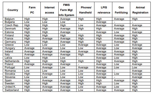
CONTENT
1      Executive Summary ......................................................................................................................... 7
2      Market need for monitoring of environmental practices for sustainable agriculture .................. 10
    2.1       Sustainable agriculture .......................................................................................................... 10
    2.2       Environmentally-friendly agricultural practices .................................................................... 10
       2.2.1         Integrating Environmental Requirements into the CAP ................................................ 10
       2.2.2         Agri-Environment Schemes ........................................................................................... 11
       2.2.3         The future of the Common Agricultural Policy.............................................................. 11
    2.3       Paying Agency monitoring requirements .............................................................................. 12
    2.4       Certification Body monitoring requirements ........................................................................ 13
    2.5       Existing EU knowledge support systems ............................................................................... 15
3 The use of remote sensing technologies for decision making, monitoring and strategic
development, at farm level ................................................................................................................... 16
    3.1       Earth observation data acquisition ....................................................................................... 16
       3.1.1         Continuous EO data collection ...................................................................................... 16
       3.1.2         Snapshot EO data collection .......................................................................................... 16
    3.2       EO data uses in agricultural decision-making........................................................................ 17
    3.3       EO data service providers ...................................................................................................... 19
    3.4       How is remote monitoring currently used at farm level? ..................................................... 20
    3.5       Farmer use of remote sensing technologies ......................................................................... 21
       3.5.1         What are remote sensing (EO) based data services? .................................................... 21
       3.5.2         How does this allow remote monitoring or replacement of on farm checks? ............. 22
    3.6       Existing Earth Observation services available for Paying Agencies and Certification Bodies 22
    3.7       Changes in PA and CB requirements for monitoring sustainable agricultural practices ...... 22
       3.7.1         Shift towards continuous monitoring............................................................................ 22
       3.7.2         COVID impacts (expediating the need for remote inspections).................................... 23
4      Analysis of current service provision ............................................................................................. 24
    4.1       Methodology ......................................................................................................................... 24
    4.2       Results ................................................................................................................................... 25
       4.2.1         Summary of results for PAs ........................................................................................... 25
       4.2.2         Current status of services .............................................................................................. 26
       4.2.3         SWOT analysis ............................................................................................................... 29
       4.2.4         Summary of results for CBs ........................................................................................... 30

                                                                                                                                                          3

                              The ENVISION project has received funding from the European Union’s Horizon 2020 research
                                              and innovation programme under grant agreement No 869366
4.2.5          Current status of services .............................................................................................. 31
      4.2.6          SWOT analysis ............................................................................................................... 34
    4.3      Conclusions from analysis of current service provision ........................................................ 35
5 The extent to which ENVISION will be able to promote sustainable development and more
effective governance of policies and environmental protection schemes ........................................... 36
6     The factors that influence adoption of agricultural technologies at farm and governance level . 38
    6.1      Adoption of remote sensing technologies and techniques .................................................. 38
    6.2      Economic considerations....................................................................................................... 39
    6.3      Institutional / regulatory considerations............................................................................... 39
    6.4      Organisational considerations ............................................................................................... 40
    6.5      Accessibility and infrastructure ............................................................................................. 41
    6.6      What may influence uptake by farmers? .............................................................................. 41
    6.7      What may influence uptake by governing bodies? ............................................................... 42
    6.8      System usability ..................................................................................................................... 44
7     Conclusions.................................................................................................................................... 46
8     References ..................................................................................................................................... 49
9     Annexes ......................................................................................................................................... 56
    ANNEX I: Existing remote monitoring services for PAs and CBs....................................................... 56
    ANNEX II: Questionnaire to survey and assess current service provision – PAs .............................. 60
    ANNEX III: Paying Agencies contacted for feedback on current service provision .......................... 68
    ANNEX IV: Questionnaire to survey and assess current service provision – CBs ............................. 70
    ANNEX V: Certifying Bodies contacted for feedback on current service provision.......................... 79

                                                                                                                                                        4

                             The ENVISION project has received funding from the European Union’s Horizon 2020 research
                                             and innovation programme under grant agreement No 869366
LIST OF TABLES
Table 1. Data types submitted to organisations by farmers for the monitoring of the six core services
of ENVISION ........................................................................................................................................... 25
Table 2. Current IT systems for remote monitoring that were identified by the organisations ........... 26
Table 3. Participation of organisations in recent remote monitoring actions using EO data ............... 26
Table 4. Organisation perception (% of total responses) of potential limitations that may hinder the
adoption of IT systems for remote monitoring of agricultural practices .............................................. 28
Table 5. Data types submitted to Certification Bodies (CB) by claimants for the monitoring of the 6 core
services of ENVISION ............................................................................................................................ 31
Table 6. Participation of certification bodies in recent remote monitoring actions using Earth
Observation (EO) data .......................................................................................................................... 32
Table 7. Certification bodies’ (CB) perception (% of total responses) of potential limitations that may
hinder the adoption of Information Technology (IT) systems for remote monitoring of agricultural
practices ................................................................................................................................................ 33
LIST OF FIGURES
Figure 1. Number of food labelling schemes managed per country (Taken from Ipsos and London
Economic Consortium, 2013) ................................................................................................................ 13
Figure 2. Overview of the socio-economic barriers for farmers in introducing PAT (Soto et al., 2019)38
Figure 3. Level of ICT and technology adaptation in the EU countries and Switzerland (Holster et al.,
2012)...................................................................................................................................................... 40
Figure 4. Highlights the obstacles PAs highlighted in using remote sensing / monitoring data for checks
(From: European Court of Auditors, 2020, Fig 12, p36) ........................................................................ 43
5
The ENVISION project has received funding from the European Union’s Horizon 2020 research
and innovation programme under grant agreement No 869366LIST OF ABBREVIATIONS BPS – Basic Payment Scheme CAP – Common Agricultural Policy CB – Certification Body CwRS – Control with Remote Sensing DIAS – Data and Information Access Services EAFRD - European Agricultural Fund for Rural Development EO – Earth Observation ESA – European Satellite Agency EU – European Union EV ILVO – The Institute for Agricultural, Fisheries and Food Research, Belgium GAEC – Good Agricultural and Environmental Condition GEOSS – Global Earth Observation System of Systems GHG – Greenhouse Gases GIS – Geographical Information System GNSS – Global Navigation Satellite System IACS – Integrated Administration and Control System IAF – International Accreditation Form IDB – Index DataBase JRC – Joint Research Centre LPIS – Land Parcel Identification System MS – Member State NDVI – Normalised Difference Vegetation Index NIR – Near Infra-Red NOA – National Observatory of Athens PA – Paying Agency RECAP – peRsonalised public sErvices in support of the implementation of the CAP (project) RFID – Radio Frequency Identification SI – Sustainable Intensification SMR – Statutory Management Requirements SWIR – Short Wave Infra-Red SWOT – Strengths, Weaknesses, Opportunities and Threats UAV – Unmanned Aerial Vehicle VHR – Very High Resolution
1    Executive Summary

Introduction

• This report explores the potential for Earth Observation data services to provide authenticating
  agencies, such as national Paying Agencies and Certification Bodies, opportunities to monitor
  agricultural practices remotely, along with the potential of these services to improve decision
  making that can facilitate the move towards more sustainable agriculture systems.

• As the global need for food increases, there a growing need to balance this production with
  environmental protection and for a move towards sustainable intensification of agricultural
  systems. Successive reforms of the Common Agricultural Policy have led towards more sustainable
  farming approaches; with subsidy payments to farmers being subject to meeting an increasing
  number of environmental measures. However, more demanding agri-environmental mechanisms
  can achieve higher environmental standards and voluntary market-based schemes allow farmers
  to achieve certification to demonstrate their compliance with higher environmental and animal
  welfare standards.

Remote assessment of compliance

• All such schemes require some form of inspection to ensure compliance with the policy measures
  and achievement of standards. Elements of these inspections can be conducted remotely, with the
  associated reduction in monitoring costs, through services and products based on Earth
  Observation data. These services are either commercial or are available for free to the end users
  and can continuously monitor indicators of vegetation health, soil quality/protection, water
  quality/availability, biodiversity and ecosystem health.

• Adoption of these services by Paying Agencies and Certification Bodies has been slow, but they
  provide such bodies an opportunity to switch from a single time-point inspection to a continuous,
  systematic monitoring process (‘checks by monitoring’) that is automated, across wider areas and
  covers all beneficiaries, thereby preparing for the post-2020 CAP changes.

• At the same time, farmers are choosing to adopt new technologies on-farm to assist with agronomic
  and management decision making. These new, data-driven, precision agricultural technologies
  generate large amounts of spatially explicit information that can improve the financial, social and
  environmental sustainability of their agricultural system. Earth Observation based services to
  arable farmers facilitate the precise and variable application of fertilisers, pesticides and irrigation
  and can provide yield mapping and predictions to improve production while minimising
  environmental impact. Livestock farmers can also benefit from animal welfare and tracking and
  pasture management while also recording indicators of greenhouse gas emissions and other
  metrics of climate impacts.

• These data can be used to provide the farmer with a picture of farm performance but can also
  provide automated evidence of compliance with regulations which can reduce their administrative
  burden. The control system for organic agriculture is due to be strengthened in 2021 and all
  certification schemes aim to continually drive up farming standards, therefore remote, continuous
  assessment is going to be needed to keep pace with change. COVID-19 has driven this by necessity,
  but changes to operating protocols are needed before longer term adoption.

                                                                                                                 7

                     The ENVISION project has received funding from the European Union’s Horizon 2020 research
                                   and innovation programme under grant agreement No 869366
Services for Paying Agencies
• Our analysis of the current EO service provision to Paying Agencies (n=14) that could allow remote
monitoring showed that they are considered by PAs to be cost-effective solutions that are available
both as generic and customised solutions with great potential to reduce non-compliance with agri-
environmental policies. They are currently working well to help monitor i) crop classification, ii) the
identification of mowing, ploughing and harvesting events and iii) the marking of non-agricultural
land to update their LPIS, predominantly for compliance checks, but also for systematic checks for
financial aid. However, 43% do not have the organisational capacity to adopt them currently
despite most of them receiving support from the EC.
• Weaknesses in these services were identified to be a lack of personnel training and knowledge on
how to use them and the accuracy level of satellite images that limit the number of agricultural
practices that can be monitored remotely.
• The additional services needed by PAs are i) monitoring of the Soil Organic Carbon, ii) identification
and monitoring of organic crop cultivations, iii) monitoring crop fertilisation and plant protection,
and iv) detection and monitoring of grazed grassland, areas under risk of soil erosion, burnt and
abandoned land, and crop seeding.
• Important aspects that need to be addressed before widespread adoption by PAs include; the need
for improved rural internet access, the use of a common platform and data format between
agencies and farmers that can link up with other IT management systems, reduced costs for
development and implementation of services, and the constant need for adaptation and change.
The 2020 European Court of Auditors report showed that those PAs who are already using EO
services for compliance checks identified that future changes and uncertainty over rules, small land
parcels and inadequate IT systems present the biggest challenges in practical terms.
Services for Certifying Bodies
• Our analysis of the current EO service provision to Certification Bodies (n=8) showed that they have
greater capacity than PAs to adopt novel IT services (88% were positive about adoption) despite
receiving less training and support. They are currently using EO services to remotely monitor crop
diversity, Soil Organic Carbon, vegetation status, crop growth, grassland management and soil
erosion, plus a few other categories, predominantly for compliance checks. A third of Certification
Bodies reported using geo-tagged photos for monitoring agricultural parcels.
• Weaknesses were identified around privacy, technical limitations such as inability to collect and
analyse crop, soil and water samples, observe and assess biodiversity, evaluate crop health, and
estimate the usage of fertilisers and pesticides.
• Opportunities for new service improvement included an increase of spatiotemporal resolution of
relevant data products to facilitate observations of inaccessible plots and for several critical growing
periods throughout the year.
• The additional services they would like include i) resource scarcity and degradation particularly of
water and fossil fuel, ii) harmful emissions, iii) insect and fungus related issues (plant health) and
crop protection practices, and iv) harvesting. Currently, on-farm inspections are still mandatory, so
a greater acceptance of remote monitoring is required before full scale adoption is possible.
8
The ENVISION project has received funding from the European Union’s Horizon 2020 research
and innovation programme under grant agreement No 869366Barriers to uptake
• For farmers, the uptake of EO-based services (predominantly as precision agricultural technologies
including machine guidance and variable rate technologies) is low across Europe. The cost (both
financial and personnel time) of adoption of precision/smart farming technologies is a barrier, data
privacy concerns and ethical implications are also important, while there are still issues relating to
access to computing technologies, IT skills and low trust in institutional frameworks. Peer-to-peer-
sharing and learning is an important approach that can build trust and confidence amongst and
between agencies and farmers. In addition, adoption could be improved with the provision of
independent informational support and demonstration of the viability of economic return.
Conclusions
• In conclusion, there is huge potential to develop EO services to help PAs and CBs to monitor scheme
compliance remotely and to incorporate on-farm data collected by precision technologies as an
evidence source. While uptake of these technologies by authenticating bodies and farmers is
currently low, the knowledge gained from bringing these together could well encourage and
promote more sustainable farming systems by providing transparent information towards
achieving a common goal.
• A trusted, robust infrastructure around the EO services is needed to ensure that all data
collection/sharing systems can ‘talk’ to each other. In addition, there needs to be a campaign to
increase awareness of the availability of these EO services alongside development of training and
support systems. However, as noted in the response from the CBs, to maximise adoption of the
ENVISION services, all stakeholders need to be involved from the start in co-creation to produce
resilient, useful, adaptable, cost-effective services that help to achieve the goal of sustainable
agriculture.
9
The ENVISION project has received funding from the European Union’s Horizon 2020 research
and innovation programme under grant agreement No 8693662 Market need for monitoring of environmental practices for sustainable
agriculture
2.1 Sustainable agriculture
The global population is growing and is expected to reach 9 billion by 2050. The goal of sustainable
agricultural systems is to meet the population’s current and increasing need for food without
compromising the ability of future generations to meet their own needs. Within this, the stewardship
of natural and human resources needs to be balanced with economic considerations. It is generally
considered that the three pillars of sustainability, social (people), environmental (planet) and economic
(resources), need to be held in a dynamic balance or the system becomes unsustainable. The
sustainable intensification of agricultural systems aims to increase agricultural yields with the use of
fewer inputs and without creating an adverse environmental impact or employing additional limited
natural resources such as agricultural land.
2.2 Environmentally-friendly agricultural practices
Adopting and maintaining environmentally-friendly agricultural practices is core to achieving
sustainable agricultural intensification. This is because agricultural malpractices can contribute to a
range of environmentally damaging effects including greenhouse gas emissions, soil degradation, loss
of soil organic carbon, water pollution and negative impacts on biodiversity.
There are various policy and market-based approaches that exist to encourage and support more
environmentally-friendly farming practices in Europe. The main policy instrument is the Common
Agricultural Policy (CAP) of the European Union which has been progressively reformed to improve the
sustainability of European farming systems (European Commission, 2020a). The CAP reforms of 2018
further increased the importance of this policy in tackling climate change and environmental
protection and aim to support farmers to contribute towards the commitments in the European Green
Deal (European Commission, 2020b). In addition to these EU-wide policies, there are Pillar II rural
development policies developed by Member States and several voluntary market-based initiatives that
support more environmentally friendly farming practices. Farmers can apply for specific certification
schemes that go beyond the requirements set out by regulation and the CAP and provide certification
that agricultural products have been produced according to a series of specific standards.
2.2.1 Integrating Environmental Requirements into the CAP
‘Cross compliance’ is the term given to the mechanism within the CAP that links direct payments to
compliance by farmers with basic standards concerning the environment, food safety, animal and plant
health and animal welfare, as well as the requirement of maintaining land in good agricultural and
environmental condition (European Commission, 2020c). In the frame of cross compliance, in order
to get support payments through the Basic Payment Scheme, farmers must not only be compliant with
18 Statutory Management Requirements (SMRs), based on pre-existing EU directives and regulations,
but also with 11 standards aimed at ensuring the “good agricultural and environmental condition”
(GAEC) of agricultural land and landscape conservation. The Statutory Management Requirements
(SMRs) are related to environment, animal and plant health, public health and animal welfare and
identification and registration of animals. The Good Agricultural and Environmental Condition (GAEC)
10
The ENVISION project has received funding from the European Union’s Horizon 2020 research
and innovation programme under grant agreement No 869366standards refer to a wide range of issues including soil protection, maintenance of soil organic matter
and structure, avoiding the deterioration of habitats, water management and maintenance of
permanent pastures.
In addition to the above, as a result of the 2013 CAP reforms, an element (30%) of the basic payment
has been conditional on the adoption of additional ‘greening’ measures, providing support to farmers
who adopt or maintain farming practices that help meet environmental and climate goals. Farmers
need to establish an agricultural production system that considers the following three actions
(European Commission, 2020d):
• crop diversification: a greater variety of crops makes soil and ecosystems more resilient;
• maintaining permanent grassland: grassland supports carbon sequestration and protects
biodiversity (habitats);
• dedicate 5% of arable land to areas beneficial for biodiversity: Ecological Focus Areas (EFA), for
example trees, hedges or land left fallow that improves biodiversity and habitats (EC website,
2020).
2.2.2 Agri-Environment Schemes
Across Europe, Agri-environment Schemes provide important sources of funding that enable farmers
to meet environmental objectives on their farms. The schemes are funded under the second pillar of
the CAP, supporting the EU’s rural development policy. These schemes include measures that are
targeting at the achievement of specific environmental objectives, such as the protection or
enhancement of biodiversity, soil, water, landscape or air quality, or climate change adaptation and
mitigation. The schemes and measures are in many cases designed to meet several environmental
objectives, and also to contribute to economic and social benefits. Farmers who choose to adopt those
specific environmental management practices and therefore go beyond the basic requirements (e.g.
cross compliance measures and greening measures in the BPS) are then eligible to claim payments for
agri-environmental measures. Agri-environmental Schemes have been are mandatory for Member
States since 1992, but enrolment is voluntary for farmers.
There is a wide variety of management practices promoted through the AES mechanism, which reflects
the complexity of both farming systems and ecosystems across the EU. Some examples of measures
include organic farming; integrated production; reducing inputs of fertilisers and/or pesticides; crop
rotation; enhancing habitats for wildlife; introducing buffer strips; managing livestock to provide the
right grazing pressure on grassland species and avoiding the risk of soil erosion; and conserving genetic
resources in agriculture and local species and in animal breeds threatened by genetic erosion.
Approximately 25% of the EU’s utilisable agricultural area is under AES contracts with farmers,
including organic farming (Science for Environment Policy, 2017), and expenditure on area based agri-
environmental measures was €2.4 billion in 2018, with a further €1.6 billion on area-based rural
development measures including organic farming (European Court of Auditors 2020)
2.2.3 The future of the Common Agricultural Policy
On 1 June 2018, the European Commission presented a number of legislative proposals on the CAP for
the period 2021-27. The proposals aim to ensure that the CAP can continue to provide strong support
for European farming, enabling prosperous rural areas and the production of high-quality food. The
future CAP will be built within a framework of a new and more ambitious green architecture which
11
The ENVISION project has received funding from the European Union’s Horizon 2020 research
and innovation programme under grant agreement No 869366combines the social, economic and environmental approaches towards achieving a sustainable system
of agriculture in the EU. The utilization of the latest advances in technology (both production and
decision-making enabling technologies) will mean that the CAP aligns with the European Green Deal,
which aims for the creation of a competitive, innovative, inclusive and environmentally friendly future
for Europe.
The role of farmers, agri-food businesses, foresters, and rural communities is essential within the
objectives of the Green Deal and is identified in a number of key policy areas, but most specifically to
the following:
• The Farm to Fork strategy building a sustainable food system (Farm to Fork Strategy – for a
fair, healthy and environmentally-friendly food system | Food Safety (europa.eu))
• Adding to the new biodiversity strategy by protecting and enhancing the variety of plants
and animals in the rural ecosystem; (EU Biodiversity strategy for 2030 | European
Commission (europa.eu))
• Contributing to the climate action of the Green Deal to achieve the goal of net-zero
emissions in the EU by 2050; (EU climate action and the European Green Deal | Climate
Action (europa.eu))
• Supporting the updated forestry strategy by maintaining healthy forests;
• Contributing to a zero pollution action plan by safeguarding natural resources such as water,
air and soil.
Monitoring and evaluation of current and future policy mechanisms included in the CAP is essential
to ensure that they are having the desired impact on environmental and climate protection.
2.3 Paying Agency monitoring requirements
The CAP is financed by the EU budget, including the European Agricultural Fund for Rural Development
(EAFRD). Each EU Member State (MS) has a Paying Agency which administers the EAFRD and provides
support payments to farmers through the Basic Payment Scheme (BPS). As outlined in section 2.2.1,
Cross Compliance is a set of rules (SMRs and GAEC codes) with which farmers need to comply in order
to receive this form of payment (European Commission, 2020c). The Paying Agencies (PAs) and their
delegated bodies must ensure the eligibility of the applications from farmers through a series of farm
checks of compliance of the management practices to the CAP rules. These are currently performed
as on-farm checks in person on a randomly selected and risk analysis-based sample of farms. Poorly
performing farms may be subject to financial penalties and risk exclusion from future support schemes.
Each Member State is responsible for the implementation of cross compliance. At first, they have to
enact the corresponding national legislation to address cross compliance at national level. Afterwards,
they have to establish a control system under which a sample of farmers (at least 1%) is checked with
a view to detecting non-compliance. In each Member State, Paying Agencies (PAs) have the
responsibility to control cross compliance requirements and assess the severity, extent, permanence
and repetition of the detected non-compliance. Farmers’ non-compliance with standards may lead to
12
The ENVISION project has received funding from the European Union’s Horizon 2020 research
and innovation programme under grant agreement No 869366reduction or, in extreme cases, cancelation of their agricultural support and rural development
payments. Additionally, apart from cross compliance, they may also be sanctioned under the local
legislation arising from the Directives concerned. The selection of farms to be checked is based on risk
analysis according to the specific legislation or to the given requirements.
2.4 Certification Body monitoring requirements
In addition to the policy mechanisms within the CAP, there are many voluntary certification schemes
for agricultural products providing assurance that certain characteristics or attributes of the product,
or production system, have been met (Gawron & Theuvsen, 2009). These schemes are monitored by
Certification Bodies (CBs). These are independent bodies that are accredited by a national
accreditation body as appointed by Member States (EC Regulation No. 765/2008) or signed up to the
multilateral recognition arrangement for product certification of the International Accreditation Form
(IAF). Certification of compliance with the scheme requirements is awarded following inspections and
scheme logos are used to denote this on food products. Inspections (certification audits) ensure that
producers in their area of responsibility follow the standards and meet verifiable criteria (European
Commission, 2010). For example, for organic certification, farms must be checked by a Certification
Body before they can market their products as organic and can demonstrate that they meet the control
measures of the EU (or equivalent for countries outside the EU) according to the EC Regulation
2092/1991. Once they have been checked and found compliant, they receive a certificate confirming
that they meet the EU requirements and can label their produce with the EU organic logo.
In addition to organic certification, other assurance schemes exist with their own logos to certify to
the consumer that the food product has met a particular set of standards (food safety, animal welfare,
environment, traceability or a combination of these). A Europe-wide study of these (Ipsos & London
Economic Consortium, 2013) found over 900 food labelling schemes, 78% of which were certification
schemes (see Figure 1). Example schemes from the UK include the Red Tractor scheme, the LEAF
Marque and RSPCA Assured.
13
The ENVISION project has received funding from the European Union’s Horizon 2020 research
and innovation programme under grant agreement No 869366Figure 2. Number of food labelling schemes managed per country (Taken from Ipsos and London Economic
Consortium, 2013)
LEAF have implemented a protocol for remote audits during the COVID-19 pandemic. As part of the
activities in Task 2.2 we will explore the integration of Earth Observation data to support remote
monitoring of these Control Points.
Exemplar Certification Scheme
The LEAF Marque aims to inspire and enable sustainable farming that is prosperous, enriches the
environment and engages local communities. The Intended Impacts of LEAF Marque are to improve:
• Soil management to enhance soil quality and soil health
• The resilience of cropping systems
• Management of water use and water quality
• Energy efficiency and energy use
• Waste management
• Management of livestock to enhance the environment
• And enhance the management of native habitats and biodiversity
All LEAF Marque audits are carried out independently, on-farm on an annual basis, either at the
same time as the baseline certification system(s), or as a stand-alone audit. The Control Points for the
audit are:
• Organisation and Planning
• Soil Management and Fertility
• Crop Health and Protection
• Pollution Control and By-Product Management
• Animal Husbandry
• Energy Efficiency
• Water Management
• Landscape and Nature Conservation
• Community Engagement
14
The ENVISION project has received funding from the European Union’s Horizon 2020 research
and innovation programme under grant agreement No 8693662.5 Existing EU knowledge support systems The Joint Research Centre (JRC), the European Commission’s science and knowledge service, supports agricultural monitoring activities and has incorporated the use of Earth Observation (EO) data as a cost-effective way to gather data on crop areas and other aspects of land use. They have developed the digital Land Parcel Identification System (LPIS) which records all agricultural parcels (a continuous area of land, declared by one farmer, which includes no more than one crop group) considered eligible for CAP payments. This is based on parcel area measurement using Global Navigation Satellite System (GNSS) devices. The JRC also support initiatives such as Control with Remote Sensing (CwRS) and the Integrated Administration and Control System (IACS) to help the European Commission and MSs to move towards sustainable farming practices with reduced environmental impacts. To support the integration of EO data into research activities, the European Commission has created 5 cloud-based platforms to facilitate and standardise access to Copernicus services (the European Union’s Earth Observation Programme). These platforms are known as the Data and Information Access Services (DIAS). These platforms provide data in suitable formats for enabling remote monitoring of land use, but there is a need for the development of new data products that can track and assess environmentally-friendly agricultural practices. It is therefore necessary to understand the possible pathways of integration of remotely-sensed EO data and farm level generated data to develop services for the continuous monitoring of agricultural parcels. A detailed review of the existing scientific and peer reviewed literature follows in the next section, to better inform the development and the use of technologies for decision making, monitoring and strategic development at a farm level. The main objective is to explore how EO data at a farm level can be used for remote monitoring of environmentally-friendly agricultural practices.
3     The use of remote sensing technologies for decision making, monitoring
      and strategic development, at farm level
“Remote sensing is the acquisition of information about an object or phenomenon from distance. This
involves an instrument or a sensor mounted on a platform, such as a satellite, an aircraft, an UAV/UGV
[Unmanned Aerial Vehicle / Unmanned Ground Vehicle], or a probe” (Weiss, 2020).

3.1     Earth observation data acquisition
Here we focus on the acquisition of information, through satellite and drone technology, for use in
decision making, monitoring and strategic development at farm level. Data collected by satellites and
drones in agricultural settings has been used to monitor (for example) (Andrew et al., 2014; Weiss,
2020):

      • Land use – extent of annual and permanent crops, crop diversity

      • Expansion or reduction of agricultural land area.

      • Management practices e.g. grazing, mowing, burning, etc.

      • Crops – growth, health, yields, etc.

      • Water – quality and abstraction.

      • Soil – cover, properties, erosion.

      • Environmental targets – related to, for example, crop diversity and land use and condition.

The data collected may be images (VHR – Very High Resolution), or multispectral data. Multispectral
data can provide detailed information on a range of crop and soil traits using comparisons between
(for example) Short Wave Infra-Red (SWIR) and Near Infra-Red (NIR) to distinguish between plants and
soil, calculate vegetation indices in order to measure variables such as crop growth, moisture and
chlorophyll content (Henrich et al., 2009; Ray and Neetu, 2017) and distinguish between different crop
types (Sitokonstantinou et al., 2018).

3.1.1    Continuous EO data collection

Monitoring of agricultural parcels with the use of remote sensing EO data may be continuous, or
employ “snapshots” – a single image or set of data collected at one point in time. Continuous
monitoring, such as that available from the Sentinel satellites can enable monitoring of a farm, region,
country for the entire year. Sentinel-1 radar satellites can, for example, provide data on crop biomass
and detect when a crop has been harvested. Sentinel-2 satellites use high-resolution cameras to
generate images which can be used to distinguish between different crop types, assess crop health
and monitor land-use. Both Sentinel-1 and 2 cover Europe every 3-4 days (European Space Agency,
2018).

3.1.2    Snapshot EO data collection

Unmanned Aerial Vehicles (UAVs), commonly referred to as drones, can offer a more of a “snapshot”
approach over a smaller area. Drones produce VHR images, offering precision. However, these images
have limited geographical coverage and do not cover the wider scope of satellites (Earth Observing

                                                                                                                 16

                     The ENVISION project has received funding from the European Union’s Horizon 2020 research
                                   and innovation programme under grant agreement No 869366
System, 2019). UAVs are high end reliable instruments and are becoming widely used by farmers to
inspect the condition of crops, permanent vegetation and soil with the use of 2D or 3D images. This
soil and field analysis provide data that can be useful for decision making about, for example, irrigation
and managing nitrogen level on fields for better crop growth. Furthermore, UAVs assist in precision
farming approaches and hence monitor the application of pesticides, water and use of fertilisers and
thus result in higher input use efficiencies. Drones may also offer a more immediate method of
detecting and responding to, for example, threats to crop health
(https://aphascience.blog.gov.uk/2019/09/20/drones/). The two methods of image and data
acquisition can complement each other and therefore provide values of Normalised Difference
Vegetation Index (NDVI) and values from multispectral sensors, thus helping farmers better track
transpiration rates and sunlight absorption rates and hence contribute to the better management of
the crop health. Also, the integration of GIS mapping with the use of drones provides the option
efficient input cost management and better business management.
3.2 EO data uses in agricultural decision-making
EO data are key inputs for the analysis and decision-making processes that are critical to enhance the
monitoring of the limited natural resources employed to produce food. Information derived from EO
systems are used to enhance the resilience of the production systems to climate shocks, water scarcity
and to allow improvements in productivity both in terms of economic efficiency and yield. EO data is
therefore considered by policy makers and farmers as an essential tool to support the monitoring of
the crop and livestock production cycle, from designing, implementing, evaluating and supporting the
development of an adaptive decision-making system.
EO data has a range of applications and uses within agriculture. These include:
Vegetation Indices
At farm level – monitoring crop growth and development through, for example, vegetation indices and
biomass monitoring. A detailed vegetation index database, the Index DataBase (IDB), lists a significant
number of remote sensing indices and is available here - https://www.indexdatabase.de/ Indices can
support yield forecasting / predictions, monitoring for diseases or pest outbreaks, providing data to
support precision farming techniques such as variable rate fertiliser applications or variable irrigation.
Crop Classification
Remote sensing data can also be used to automatically distinguish between crops / classify crop types.
(Schmedtmann and Campagnolo, 2015; RECAP, 2018a, 4.4, p29/30; Kussell et al., 2016;
Sitokonstantinou et al., 2018). This can enable monitoring of crop diversity, land use and monitoring
of buffer zones and field margins (Sitokonstantinou et. al., 2018) and potentially features such as
hedgerows (Bégué et al, 2018). See also https://www.ceh.ac.uk/crops2015
Monitoring potential environmental violations and support policy implementation
The recent advances in the technologies of EO have increased the ability to inventory, monitor and
evaluate the status of both natural and artificial ecosystems (Patias et al. 2020). Hence, EO data can
be used for monitoring farmland in order to check compliance with the conditions required for
subsidies and payments.
17
The ENVISION project has received funding from the European Union’s Horizon 2020 research
and innovation programme under grant agreement No 869366EO monitoring for sustainability and environmental reasons
Tied in with various aspects, such as compliance monitoring or the sustainable intensification of
agriculture, EO data can be used for yield predictions; land use analysis; monitoring of changes in
farmland area; and monitoring aspects of climate change. It is therefore possible for EO to provide a
readily accessible, long-term database with EU and global coverage that incorporates both spatial and
temporal resolutions. Hence, EO could significantly contribute to SI assessments, providing
opportunities to quantify agricultural intensity and environmental sustainability.
The list below summarises the potential EO-based indicators which could be used to assess
environmental sustainability.
Indicators of Environmental Sustainability
Vegetation health
• Crop condition
• Biophysical traits inc. biomass, fraction of absorbed photosynthetically active radiation (fAPAR),
photosynthetic activity
• Structural traits inc. crop/canopy height, leaf area index (LAI), biomass, canopy morphology
• Biochemical traits inc. chlorophyll (Ch), water content, nitrogen (N) and phosphorus (P)
Soil Quality
• Soil organic carbon (SOC)
• Soil organic matter (SOM)
• Soil moisture content
• Soil salinity
• Crop residue/conservation tillage density
• Nitrogen status/availability
Soil erosion/protection
• Vegetation cover
• Erosion feature detection
• Erosion modelling e.g. USLE
Water Quality
• Water Quality Indices derived from different spectral band combinations
• Physical water quality parameters incl. total suspended solids (TSS), turbidity, suspended sediment
concentration (SSC), chlorophyll concentration, temperature and water clarity
• Chemical water quality parameters incl. concentration of total nitrogen, NO3-N (nitrate as nitrogen)
and total phosphorus
• Water quality proxy e.g. health of vegetation alongside water bodies
Water Availability
• Water body area and configuration
• Water use efficiency and crop water stress
• Water level and volume
18
The ENVISION project has received funding from the European Union’s Horizon 2020 research
and innovation programme under grant agreement No 869366Biodiversity
• Direct mapping of individuals and associations
• Plant (and animal) species diversity
• Habitat suitability based on known habitat requirements of specific species
• Species Richness
• Landscape structure inc. composition, isolation and complexity
• Invasive Species
Ecosystem Health
• Vigour - Net Primary Productivity (NPP) & Gross Primary Productivity (GPP) - Fractional cover of
green vegetation, non-photosynthetic vegetation (NPV) and bare soil - Biochemical properties inc.
nitrogen, phosphorus and chlorophyll
• Organisation
• Resilience - Species richness and biodiversity
• Ecosystem Services as a Proxy for Ecosystem Health - Vegetation structural traits
List adapted from Hunt et al. (2019)
3.3 EO data service providers
Data from the Sentinel satellites is freely available through the Copernicus platform
(https://land.copernicus.eu/). A wide range of commercial companies and organisations offer services
in using and interpreting remote sensing data for monitoring crops and farmland and supporting
agricultural decision making, for example;
• SatAgro - www.satagro.pl/
• Agricolus - www.agricolus.com/en/
A number of EU Horizon 2020 projects have investigated the use of EO / satellite data to support
agricultural and environmental monitoring and decision making. Examples include:
• EOMORES (H2020 project), monitoring water quality https://eomores.eu/
• Demeter (H2020 project) digital farming https://h2020-demeter.eu/
• RECAP (H2020 project) monitoring cross compliance (https://www.recap-h2020.eu/)
In addition, a wide range of organisations and companies offer services and expertise in relation to EO
data and agricultural monitoring. A list of current providers of EO services has been gathered and
categorised (See Annex I). The list aims to summarise the available tools for providing services in
relation to a number of areas, including: monitoring performance; assessing land derived inputs; policy
evaluation and implementation; reducing farmer administration burden and improve decision making;
promote synergies amongst stakeholder groups; provide an early warning system; enhance
productivity and support the sustainable intensification of agricultural systems. These services are
either commercial or are available for free to the end users (farmers, PAs, CBs, agribusiness
consultants). The table in Annex I gives information about the different EU research projects, service
provision companies and start-ups, as well as a short description of the objectives and the services
provided. The information was used in the design of the questionnaire to PAs, CBs and lighthouse
stakeholders of ENVISION to carry out a SWOT (Strengths, Weaknesses, Opportunities and Threats)
19
The ENVISION project has received funding from the European Union’s Horizon 2020 research
and innovation programme under grant agreement No 869366analysis of the current technologies in terms of the technical and operational requirements.
Furthermore, these will be used as reference points across the tasks of WP2 to continuously review
and assess the current status of commercial and non-commercial services.
3.4 How is remote monitoring currently used at farm level?
Remote monitoring at farm level plays an important role in precision agriculture. Precision agriculture
is defined as ‘a whole-farm management approach using information technology, satellite positioning
(GNSS) data, remote sensing and proximal data gathering. These technologies have the goal of
optimising returns on inputs whilst potentially reducing environmental impacts’ (European Parliament,
2014). The opportunities available to EU farmers for the adoption of precision agriculture and the
potential support for the CAP in terms of monitoring and implementation are presented in report from
the DG for internal policies1. The document highlights how precision agriculture has become possible
thanks to the development of sensor technologies combined with procedures to link mapped variables
to appropriate farming practices such as tillage, seeding, fertilization, herbicide and pesticide
application, harvesting and animal husbandry. The report covers applications in the arable, livestock,
fruits and vegetables and the viticulture sectors.
This gathering and analysis of remote monitoring data supports and enables a range of measures at
farm-level such as:
• precision and variable rate applications of fertilisers (Basso et al., 2015) and pesticides
(Campos et al., 2020),
• precision irrigation (de Lara et al., 2019)
• yield monitoring and predictions (Toscano et al., 2019; d’Andrimont et al., 2020).
Precision agriculture and remote monitoring can also play a substantial role in livestock farming, often
in animal welfare and tracking. There may also be remote monitoring of pasture and grassland (Estel
et al., 2018) and the variable rate application of manure (Baille et al., 2018) can involve remote
monitoring. However, there is less of a focus on the use of EO data from satellites or drones, with
wider use of remote monitoring via Radio Frequency Identification (RFID) tags and sensor networks
monitoring (for example) ambient temperature and feed intake (O’Grady and O’Hare, 2017).
Precision agriculture is seen as a potential route to sustainable intensification (SI) within agriculture,
enabling monitoring of crops and livestock and adjusting farm management practices accordingly to
improve sustainability (Dicks et al., 2018). This collection and analysis of remote sensing data can also
contribute towards various environmental measures, such as
• mitigating greenhouse gas emissions (Soto et al., 2019),
• measuring variables in crops associated with climate change
• measuring crop growth / estimating yields in areas vulnerable to food insecurity (Becker-
Reshef, 2020)
1
https://www.europarl.europa.eu/RegData/etudes/note/join/2014/529049/IPOL-
AGRI_NT%282014%29529049_EN.pdf
20
The ENVISION project has received funding from the European Union’s Horizon 2020 research
and innovation programme under grant agreement No 869366Remote sensing data is also currently used to monitor agricultural land for compliance. Within the EU,
Paying Agencies (PAs) and Certification Bodies (CBs) can use EO data to monitor farmland and check
compliance.
Each EU Member State (MS) has a Paying Agency (or Paying Agencies)2, entities responsible for
monitoring farmers’ performance in relation to the environmental rules stemming from EU policy. The
current practice is that these entities mainly perform on-farm checks (on a randomly selected and risk
analysis-based sample of farmers), and farmers with poor performances in relation to their subsidies’
requirements are subject to penalties which may include exclusion from participation in funding
schemes and/or monetary fines. This monitoring system partly relies on Control with Remote Sensing
(CwRS) with the use of EO data: Very High Resolution – VHR and High Resolution – HR (10-20m) images.
With regard to agricultural certifications within Europe, inspection and certification for agricultural
products is conducted by Certification Bodies (CBs)3. These entities have to inspect several
requirements, and perform on-farm checks once per year, to ensure that farmers applying for a specific
certification have met the required standards. From 2021, there will be an overhaul of the current
regulations for organic farming, reflecting the changing nature of this rapidly growing sector (the global
market accounted for 50.9 million ha of farmland in 2015 and is expected to expand at a growth rate
of 8.4% by 20264 - overall valued at US$ 81.6 billion in 20154). According to the EU regulation 2018/848
on Organic Production and Labelling of Organic Products, due to come into force in 2021, the control
system will be strengthened thanks to tighter precautionary measures and robust checks along the
entire supply chain.
With the changing CAP rules regarding remote monitoring, both PAs and CBs are able to use remote
sensing data in order to monitor compliance. A survey undertaken by the European Court of Auditors
of 66 PAs found 15 had used Copernicus Sentinel data in 2019 to check some aspects of compliance
(European Court of Auditors, 2020). The report also highlights data from the JRC showing that “across
the EU an average of 80 % of field inspections are now performed using remote sensing”.
3.5 Farmer use of remote sensing technologies
3.5.1 What are remote sensing (EO) based data services?
Remote sensing data may involve very high resolution (VHR) images or large amounts of data requiring
processing, analysis and interpretation before it can be utilised by farmers, PAs and CBs. Companies
and organisations, commercial and non-for-profit, offer data services in collating and interpreting EO
data, for example monitoring land cover and generating vegetation indices (See Annex I). Data and
Information Access Services (DIAS) is one example. This was funded by the European Commission and
comprises five cloud-based platforms providing centralised access to Copernicus data and information
and processing tools (both open source and pay-per-use). DIAS offered its services in the form of
online platforms to discover, manipulate, process and download Copernicus Sentinel data and
information.
2 A Paying Agency is responsible for the management and control of CAP expenditure. Currently, 78 PA for EAFRD are operating within the
28 MS.
3 Certification Bodies are independent bodies appointed by the Commission to ensure that organic producers in their area of responsibility
follow the standards and control measures of EU, or equivalent to the them for countries outside the EU.
4
https://www.globenewswire.com/news-release/2019/01/25/1705536/0/en/Global-Organic-Farming-Market-is-Expected-to-Exhibit-a-
Growth-Rate-of-8-4-by-2026.html
21
The ENVISION project has received funding from the European Union’s Horizon 2020 research
and innovation programme under grant agreement No 869366You can also read