Review of potential marine sand resources for beach renourishment in the Hunter-Newcastle region - SERIES/PROGRAM NAME INSERT SPACE IF NOT ...
←
→
Page content transcription
If your browser does not render page correctly, please read the page content below
SERIES/PROGRAM NAME (INSERT SPACE IF NOT NEEDED)

Review of potential marine sand resources for
beach renourishment in the Hunter–Newcastle
region
Discussion paper subtitle (insert space if not needed)
May 2020

                 Regional NSW | nsw.gov.au/RegionalNSW
Published by Regional NSW | nsw.gov.au/RegionalNSW

Title: Review of potential marine sand resources for beach renourishment in the Hunter–Newcastle region

[Subtitle]

First published: May 2020

Department reference number: DOC20/339586

© State of New South Wales through Regional NSW 2020. You may copy, distribute, display, download and otherwise freely deal with
this publication for any purpose, provided that you attribute Regional NSW as the owner. However, you must obtain permission if you
wish to charge others for access to the publication (other than at cost); include the publication in advertising or a product for sale; modify
the publication; or republish the publication on a website. You may freely link to the publication on a departmental website.

Disclaimer: The information contained in this publication is based on knowledge and understanding at the time of writing (May 2020)
and may not be accurate, current or complete. The State of New South Wales (including Regional NSW), the author and the publisher
take no responsibility, and will accept no liability, for the accuracy, currency, reliability or correctness of any information included in the
document (including material provided by third parties). Readers should make their own inquiries and rely on their own advice when
making decisions related to material contained in this publication.
Review of potential marine sand resources for beach renourishment in the Hunter –Newcastle region

Executive summary
The City of Newcastle has undertaken several studies to address the problem of the ongoing
erosion of the southern end of Stockton Beach, adjacent to the suburb of Stockton. Mining,
Exploration and Geoscience (MEG) in Regional NSW was asked by the Deputy Premier to
undertake a desktop study to identify marine sand bodies that may be suitable for beach
renourishment at Stockton Beach.
Some key historical data has not been located. The available data indicates that the medium-
grained, quartzose sands of the Newcastle inner shelf sand sheet (ISSS) on the floor of Stockton
Bight appear to be suitable for beach renourishment and represent the largest potential sand
resource in Stockton Bight. However, the extent, thickness and continuity of the sand sheet is
unclear and further investigation is required to confirm its suitability.
The lobe and spoil dumps off Nobbys Head also contain sand that may be suitable. However,
some data suggest that the composition and grain size of the sand in these areas may not be as
uniform as that of the Newcastle ISSS.
More data needs to be acquired to properly assess and locate sufficient volumes of suitable sand
for the renourishment of Stockton Beach.
This report makes three key recommendations for further work:
   1.      That MEG continues its attempts to locate previous data.
   2.      That a comprehensive offshore sampling program is undertaken to identify and better
           characterise a suitable sediment source for Stockton beach renourishment.
   3.      That a collaborative project team comprising experts from the relevant government
           agencies is established to progress the offshore sampling program.

                                                                          Regional NSW | GS report 2020/0485 | i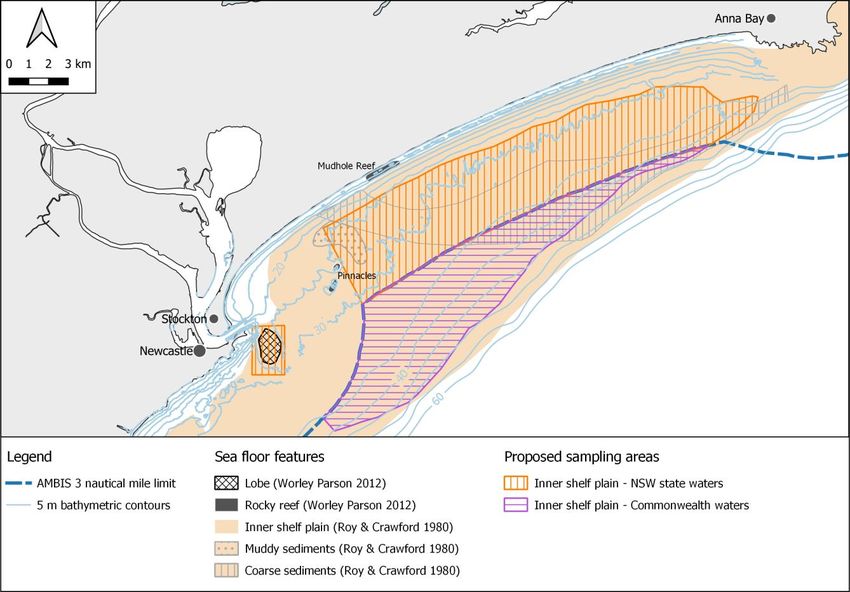
Review of potential marine sand resources for beach renourishment in the Hunter –Newcastle region

Contents
Introduction ................................................................................................................................... 1
   Objectives ................................................................................................................................... 1
   Previous studies .......................................................................................................................... 2
NSW coastal environment and sand sources ............................................................................. 3
   NSW inner continental shelf ........................................................................................................ 3
   Morphology of Stockton Bight ...................................................................................................... 3
      Near shore zone ...................................................................................................................... 4
      Inner shelf plain ....................................................................................................................... 4
   NSW offshore sand sources ........................................................................................................ 5
      Identified marine sand resources ............................................................................................. 7
Stockton Bight sand sources....................................................................................................... 8
   Description of sand sources ........................................................................................................ 9
      Near shore sands .................................................................................................................... 9
      Inner shelf unconsolidated sediment ........................................................................................ 9
      Newcastle inner shelf sand sheet........................................................................................... 10
      Lobe ...................................................................................................................................... 10
      Dredge spoils ......................................................................................................................... 10
   Suitability of sand for beach renourishment ............................................................................... 11
   Other considerations ................................................................................................................. 13
Conclusions and summary of recommendations ..................................................................... 15
References .................................................................................................................................. 16
Appendix 1 – Data used in review.............................................................................................. 18
      Bathymetry survey ................................................................................................................. 18
      Sediment data........................................................................................................................ 20
      Geophysical data ................................................................................................................... 21

Figures
Figure 1. Stockton Beach location map, showing the proposed study area and the limit for NSW
waters. ............................................................................................................................................ 1
Figure 2. 3-D view of the south eastern Australian margin (modified from Boyd et al. 2004). .......... 3
Figure 3 Bathymetry and morphological zones (Roy & Crawford 1980). ......................................... 4
Figure 4 NSW marine sand bodies location map (adapted from NSW Trade & Investment 2016)... 6
Figure 5. Interpreted sand units of Stockton Bight. .......................................................................... 7
Figure 6. Sediment grain size superimposed on sediment units (Roy & Crawford 1980). ................ 9
Figure 7. Interpreted depth to bedrock along two NW-SE oriented seismic profiles (adapted from
Andrews et al. 1979). The locations of the interpreted sections are shown in Figure 5. ................. 10

                                                                                                     Regional NSW | GS report 2020/0485 | ii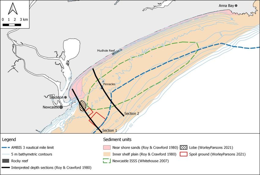
Review of potential marine sand resources for beach renourishment in the Hunter –Newcastle region

Figure 8. Proposed investigation areas in Stockton Bight.............................................................. 12

Tables
Table 1. Summary of physical characteristics of Stockton Beach sands and offshore samples
(WorleyParsons, 2012). ................................................................................................................ 12

                                                                                            Regional NSW | GS report 2020/0485 | iii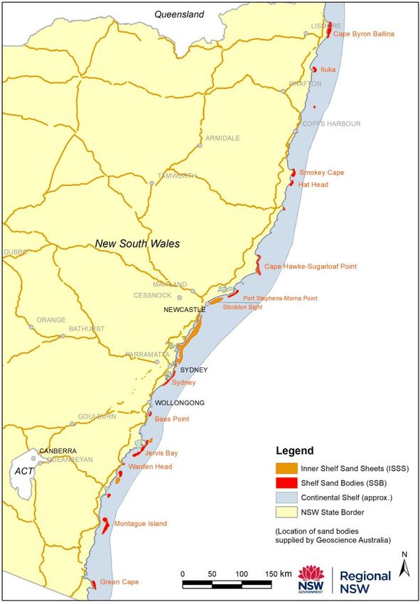
Review of potential marine sand resources for beach renourishment in the Hunter –Newcastle region

Introduction
Stockton Bight stretches 32 km northwards from the Stockton breakwall at the entrance to the
Hunter River to Morna Point, east of Anna Bay (Figure 1). Stockton Beach borders the length of
the bight and the suburb of Stockton is located at the southern end of the bight and beach, within
the Newcastle local government area.
The City of Newcastle has undertaken several studies to address the problem of the ongoing
erosion of the southern end of Stockton Beach, adjacent to the suburb of Stockton. These studies
have been summarised in the Newcastle Coastal Zone Management Plan (NCZMP) 2018.
The NCZMP (2018) identified that beach renourishment is necessary for any of the options
proposed to remediate the issue. Long-term sediment transport modelling has shown that Stockton
Beach has experienced northward transport of sediment of approximately 20 000–30 000 m3 per
year. WorleyParsons (2012) identified that between 410 000 m3 and 515 000 m3 of sand are
required initially to replenish the sand that has been lost from the beach, with an ongoing annual
maintenance replenishment of up to 30 000 m3 per year.
The draft Stockton Coastal Management Program (Stockton CMP) (Patterson & Turnbull 2020)
has provided revised volumes of sands required for renourishment of 2.4M m3 initially and
112 000 m3 annually for maintenance, which is likely to increase with time. The Stockton CMP
concluded that given these volumes, terrestrial sources are neither available, or environmentally,
socially or economically viable, and that offshore sand sources are the most economically feasible
solution.

  Figure 1. Stockton Beach location map, showing the proposed study area and the limit for NSW
                                            waters.

Objectives
Mining, Exploration and Geoscience (MEG) in Regional NSW was asked by the Deputy Premier to
undertake a desktop study to identify marine sand bodies that may be suitable for beach
renourishment at Stockton Beach. This preliminary study will need to be followed by a program of
new data acquisition to confirm the presence of a suitable resource. The program would need to
include seafloor mapping and sampling to quantify the size and quality of the sand bodies.

                                                                           Regional NSW | GS report 2020/0485 | 1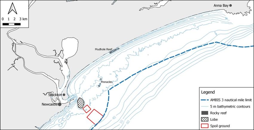
Review of potential marine sand resources for beach renourishment in the Hunter –Newcastle region

Previous studies
Field studies on the physical and geochemical properties of sand deposits on the inner continental
shelf of NSW date back to the mid 1970s. These investigations into marine sand bodies have been
conducted by various council and government agencies, universities and private companies.
Resource depletion and increasing land constraints to onshore sand resources has led to
companies looking for options offshore along the coast of NSW. Key reports, particularly those that
contain data relevant to this study include:
   •   Manly Hydraulics Laboratory (MHL) (1977) Sediment Movement in Newcastle Bight. Report
       No. 206. This report includes a summary of data provided by Ly (1976) and Roy and NSW
       Department of Mines (1977).
   •   Andrews, Ringis & Lean (1979) Marine Geophysical Surveys in Newcastle Bight. New
       South Wales Geological Survey, Department of Mines.
   •   Roy and Crawford (1980) Quaternary Geology of the Newcastle Bight Inner Continental
       Shelf, New South Wales, Australia. New South Wales Geological Survey – Records 19(2),
       1455-188. Roy & Crawford (1980) collected 261 samples that included surface sediment
       samples from a small bucket dredge as well as hand sampling from the beach and surf
       zone. Subsurface sediment data came from power auger holes in the outer barrier and in
       the beach. This is the most extensive of the sediment sampling programs within the bight.
   •   Roy & Stephens (1980) Regional Geological Studies of the NSW Inner Continental Shelf.
       New South Wales Geological Survey, Department of Mines.
   •   Roy (2001) Sand Deposits of the NSW Inner Continental Shelf.
   •   Umwelt (2002) Shifting sands at Stockton Beach. Report No. 1411/R04/V2.
   •   Boyd, Ruming & Roberts (2004) Geomorphology and surficial sediments of the southeast
       Australian continental margin, Australian Journal of Earth Sciences, 51, 743–764.
   •   DHI Water and Environment (2006) Stockton Beach Coastal Processes Study.
   •   Whitehouse (2007) Evaluation of mineral resources of the continental shelf, New South
       Wales. Quarterly Notes of the Geological Survey of New South Wales, 124.
   •   Neilson et al (2011) Stockton Beach Nourishment Scoping Study.
   •   WorleyParsons (2012) Stockton Beach Sand Scoping and Funding Feasibility Study.
   •   City of Newcastle (2018) Newcastle Coastal Zone Management Plan.

                                                                          Regional NSW | GS report 2020/0485 | 2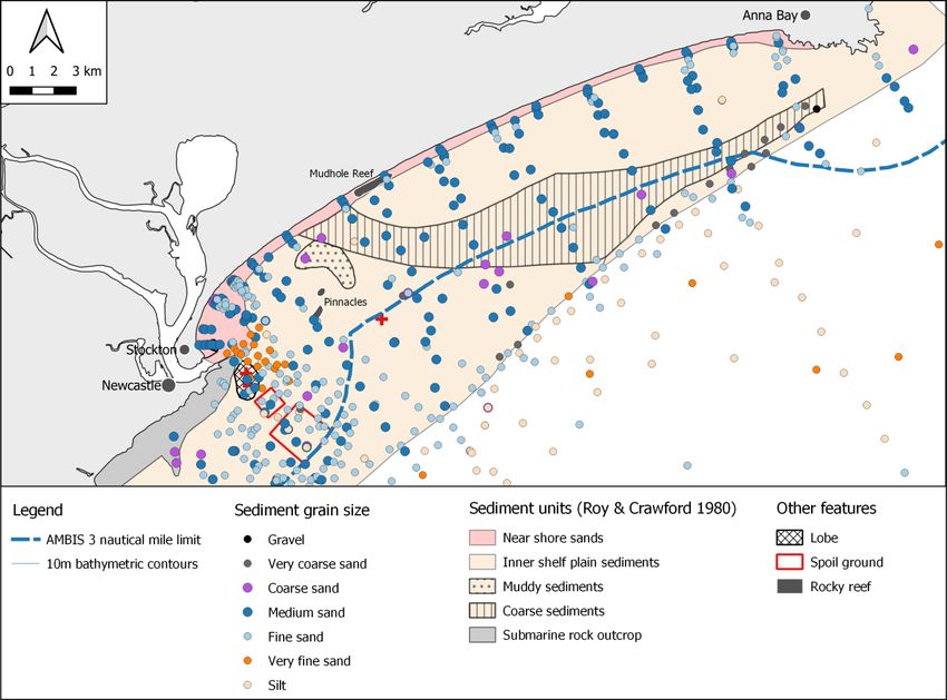
Review of potential marine sand resources for beach renourishment in the Hunter –Newcastle region

NSW coastal environment and sand sources
NSW inner continental shelf
The continental shelf extends eastwards from the NSW coastline as a relatively flat submarine
plain and is approximately 50 km wide near Newcastle (Figure 2). In this location, the water depth
at the shelf edge is 150 m, and there is an abrupt change in slope marking the beginning of the
continental slope. The inner continental shelf occupies a region along the entire NSW coastline in
water depths of 20–60 m, encompassing an area of 8 000 km2.
The entire surface of the NSW inner continental shelf is covered with sand and minor gravel,
except in areas where bedrock reefs outcrop on the seabed. The enormous quantities of sand on
the inner continental shelf constitute a potentially viable resource of sand for renourishment of
beaches along the NSW coastline (Roy 2001).

       Figure 2. 3-D view of the south eastern Australian margin (modified from Boyd et al. 2004).

Morphology of Stockton Bight
The Stockton Bight (often referred to as Newcastle Bight in previous studies) is a gently curved
embayment that stretches 32 km east-northeast from the mouth of the Hunter River at Newcastle
northwards to Morna Point, just east of Anna Bay. The New South Wales continental shelf reaches
its maximum width of about 50 km in the region offshore from Newcastle (Roy & Crawford, 1980).
A study on the sediments and morphology within the Newcastle Bight completed by Roy &
Crawford (1980) mapped four subparallel zones (Figure 3):
   •    nearshore slope zone
   •    inner shelf plain
   •    inner shelf slope
   •    outer shelf plain.

                                                                            Regional NSW | GS report 2020/0485 | 3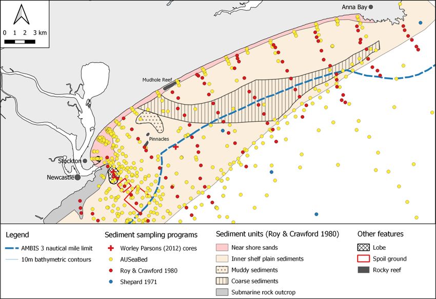
Review of potential marine sand resources for beach renourishment in the Hunter –Newcastle region

               Figure 3 Bathymetry and morphological zones (Roy & Crawford 1980).

Near shore zone
The near shore zone (NSZ) extends from the beach to depths of 20–30 m before the gradient
flattens out onto the inner plain. The NSZ is usually only ~1000–3000 m wide (Boyd et al. 2004)
and can be divided into an upper and lower segment. The upper segment includes Stockton
Beach, while the lower segment is characterised by a steep seawards slope where submarine rock
outcrops off the rocky headlands at either end of the Stockton Bight (Roy & Crawford 1980).
The NSZ profile is a response to wave energy on the shoreline, its depth limit of ~30 m reflects the
area of high wave energy. The NSZ is deepest and steepest in areas of the greatest wave energy,
typically at the northern end of major coastal compartments (Boyd et al. 2004).

Inner shelf plain
The inner shelf plain is a seaward-sloping surface occurring between 20–65 m depth, between 1.5
km and 11 km wide with an average gradient of 0.05–0.42° (Boyd et al. 2004). The outer boundary
terminates at the steepening top of the inner shelf slope. At two locations, within the inner shelf
plain in Stockton Bight, bedrock peaks crop out through the sediment cover; the Pinnacles rise
from 24–19 m water depth and the Rock Peaks at the northern end rise from 35–28 m water depth
(Figure 3).

                                                                           Regional NSW | GS report 2020/0485 | 4
Review of potential marine sand resources for beach renourishment in the Hunter –Newcastle region

NSW offshore sand sources
The New South Wales continental shelf hosts vast quantities of sand in water depths of 20–70 m
(Whitehouse 2007). The shelf sand is mostly quartzose, fine-to medium-grained, less commonly
coarse-grained and due to the energetic wave regime contains almost no mud (Whitehouse 2007).
A comprehensive study conducted by Roy (2001) described two main types of marine sand
deposits on the inner shelf (Figure 4);
   •   Inner shelf sand sheets (ISSS)
   •   Shelf sand bodies (SSB).
Inner shelf sand sheets (ISSSs) form surficial sheet-like units typically 0.25–1.5 m (and up to 5 m)
thick and occupy a coast parallel zone 5–10 km wide in water depths of 20–70 m across about
70% of the inner shelf (Whitehouse 2007). Mostly, ISSSs consist of clean, medium-grained sand
with a variation of shell gravels near reefs and irregular patches of coarse gravelly sand commonly
near the toe of eroding shorefaces (Roy 2001). Over time, ISSSs have been subject to wave
reworking that has winnowed out the finer sand component and transported it shoreward resulting
in ISSSs being coarser than the underlying sediment (Roy 2001) making them suitable for beach
renourishment (Whitehouse 2007).
SSBs form linear, shore parallel deposits off prominent headlands generally less than 5 km from
the coast (Roy 2001). They are typically 20–30 m thick, 5–40 km long and 2–4 km wide
(Whitehouse 2007). Composition consists of fine- to medium-grained, moderately to well sorted
quartz sand with 10–15% biogenic carbonate (shells) and usually < 1% mud (Roy 2001). SSB
sand is well suited to concrete manufacturing and industrial applications, including glass
manufacturing, but ls less suitable for beach renourishment than the ISSSs (Whitehouse 2007).
In Stockton Bight, the Newcastle ISSS is present on the inner shelf plain (Figure 5). No SSBs
occur within the study area.
In addition, close to the Newcastle Harbor entrance, there are two other potential sources of sand
for beach renourishment, as identified by WorleyParsons (2012): the large sand lobe off Nobbys
Head and the dredged sediment spoil grounds located approximately 3 km off Nobbys Head in 25–
30 m water depth (Figure 5).

                                                                           Regional NSW | GS report 2020/0485 | 5
Review of potential marine sand resources for beach renourishment in the Hunter –Newcastle region
Figure 4 NSW marine sand bodies location map (adapted from NSW Trade & Investment 2016).
Regional NSW | GS report 2020/0485 | 6Review of potential marine sand resources for beach renourishment in the Hunter –Newcastle region
Figure 5. Interpreted sand units of Stockton Bight.
Identified marine sand resources
There is a large amount of scientific information available relating to marine sediments in Australia
generally, although very little exploration has occurred to allow evaluation of potential uses for
many of the marine sand bodies on the inner continental shelf of NSW (NSW Trade & Investment
August 2016).
Most of the NSW offshore exploration for sand has occurred in the Sydney area, commencing in
the late 1970s when a consortium of companies defined a potential construction sand resource of
approximately 21 Mt within the entrance to Broken Bay.
A total of approximately 3000 Mt of sand has been defined from sand bodies located on the inner
continental shelf offshore from Sydney, from Black Head in the south to Swansea in the north. The
resources occur as ISSSs and SSBs and consist of fine- to coarse-grained sand in water 25–75 m
deep.
Due to the cost of transport, it is unlikely that the sand resources identified offshore from Sydney
could be cost-effectively used for beach renourishment at Stockton. To reduce transport costs
potential sand sources should be located relatively close, in Stockton Bight.
Regional NSW | GS report 2020/0485 | 7Review of potential marine sand resources for beach renourishment in the Hunter –Newcastle region
Stockton Bight sand sources
Five sediment units in Stockton Bight have been assessed in this review:
• near shore sands
• inner shelf plain unconsolidated sediments
• Newcastle inner shelf sand sheet
• lobe
• dredge spoil.
To assess these five units all available data (Appendix 1) were compiled from the previous
investigations to assess the location, size and quality of marine sand bodies, including:
• Bathymetric data – new topographic (elevation) and bathymetric (depth) data were acquired
for the NSW coast July to December 2018 to water depths of 30 m. A hydrographic survey
is planned for Stockton Bight for FY2019/2020 by the Australian Hydrographic Office on
behalf of the Department of Defence under the HydroScheme 2020 program. This survey
will join the new bathymetry data and will greatly assist in understanding the beach
morphology and processes in water depths between 30 m and 100 m in the Stockton Bight.
• Sediment data –were sourced from the AUSeaBed database (Jenkins 2001), MARine
Sediments (MARS) database and a range of published reports (Shepard 1971; Roy &
Crawford 1980; WorleyParsons 2012).
• Geophysical data – primarily seismic data that allows for the thickness of sand bodies and
their lateral extent to be imaged below the sea floor. These are important data in estimating
the volumes of sand bodies and modelling their 3D geometry. Unfortunately, MEG does not
currently have the high-resolution seismic data (Andrews et al. 1979) that covers most of
the inner shelf plain in Stockton Bight.
Recommendation 1
There have been numerous surveys in Stockton Bight since the 1960s. However, not all
previously acquired data were located prior to completion of this review. It is recommended
that MEG should:
• Continue attempts to locate and compile results of all previous sediment ‘grab and
coring’ sampling.
• Continue attempts to locate and then reprocess the high-resolution seismic data
acquired by Andrews et al. (1979) to map the lateral and vertical extent of the sand
bodies.
• If the high-resolution seismic data of Andrews et al. (1979) cannot be found, consider
reacquiring the seismic data. Geoscience Australia have indicated that their seismic
equipment may be available for use in early 2021.
• Obtain, when competed, the additional Stockton Bight bathymetric data from the
Australian Hydrographic Office under the Hydroscheme 2020 program, to support
modelling of the beach dynamics and investigate opportunities to extend this survey to
cover the southwestern end of Stockton Bight.
Regional NSW | GS report 2020/0485 | 8Review of potential marine sand resources for beach renourishment in the Hunter –Newcastle region
Description of sand sources
Near shore sands
Mean grain sizes for the near shore sands range from fine to coarse and are usually well to very
well sorted (Roy 2001) (Figure 6). The native beach material of Stockton Beach was found to be
medium to medium–coarse sand with a mean grain size of 0.40 mm (WorleyParsons 2012).
As the near shore sands are in the active beach zone they are not considered a suitable source for
beach renourishment due to potential environmental impacts.
Figure 6. Sediment grain size superimposed on sediment units (Roy & Crawford 1980).
Inner shelf unconsolidated sediment
The high-resolution seismic survey of the Stockton Bight (Andrews et al. 1979) showed there is
greater than 30 m of unconsolidated overlying the bedrock in the Stockton Bight (Figure 7). At this
time the properties of this sediment unit are not known and whether it is a potentially viable source
of sand for beach renourishment. High-resolution seismic data and coring would be required to
make this assessment.
Overlying the unconsolidated unit are three sand sources located on the inner shelf plain (Figure
7), namely the Newcastle inner shelf sand sheet, lobe and dredge spoils. All three are believed to
form a relatively thin veneer over the thicker package of unconsolidated sediments.
Regional NSW | GS report 2020/0485 | 9Review of potential marine sand resources for beach renourishment in the Hunter –Newcastle region
Figure 7. Interpreted depth to bedrock along two NW-SE oriented seismic profiles (adapted from
Andrews et al. 1979). The locations of the interpreted sections are shown in Figure 5.
Newcastle inner shelf sand sheet
Roy & Crawford (1980) described the inner shelf plain sediments of the Stockton Bight as a
medium- to coarse-grained, poorly sorted relict sand with a mean grain size ranging from 0.29–
0.71 mm. A characteristic of ISSSs is their typically brown to dark brown colour due to extensive
iron staining, which increases with water depth (Roy 2001). A band of coarse sediments (Figure 6)
was identified by Roy & Crawford (1980) that may correlate with an ancient arm of the Hunter
River.
WorleyParsons (2012) described the Newcastle ISSS, at water depths of 20–40 m, as a well
sorted quartz sand, with less than 3% gravel. The sediment data reviewed by MEG (Figure 6),
shows the ISSS to be mainly composed of medium to medium–coarse sand. Based on the
distribution of the medium to medium–coarse sand it appears that the sediments sampled and
described by Roy & Crawford (1980) correlate with the Newcastle ISSS, suggesting it may cover
the majority of the inner shelf plain. However, at this time its thickness, uniformity and continuity
are not known.
Lobe
A large, oblate shaped sand lobe extends off Nobbys Head in a south easterly direction (Figure 5).
It is estimated to be about 4.4 km wide, averaging 2–3 m thick with a maximum thickness of 7.5 m
(WorleyParsons 2012). Core sampling by WorleyParsons (2012) showed the sands to be medium
to medium–coarse grained and suitable for beach renourishment.
Previous surface sediment samples taken on the lobe (Figure 6) also indicated that the lobe is
mostly composed of medium to medium–coarse sands. However, the presence of considerably
more fine-grained material around the entrance to Newcastle Harbour makes further sampling of
the lobe necessary to confirm its suitability as a source of sand for Stockton Beach renourishment.
Dredge spoils
There are several sediment spoil grounds, made up of material dredged from Newcastle Harbour,
located offshore of Nobbys Heads. The spoil grounds, which have shifted over the past 40 years
during several projects (BHP, Port Waratah Coal Services, Newcastle Coal Infrastructure Group),
occur in water depths of 25–40 m.
Regional NSW | GS report 2020/0485 | 10Review of potential marine sand resources for beach renourishment in the Hunter –Newcastle region
As with the lobe, the sediment data (Figure 6) indicates the spoil grounds dominantly comprise
medium to medium coarse sand. However, the presence of fine-grained sediment will require
additional sampling to quantify the amount of this fine-grained sediment.
Suitability of sand for beach renourishment
Assessing sources of sand for the Stockton Beach renourishment project requires comparing the
existing beach sand with potential sources. The native beach material is a medium to medium–
coarse sand with a mean grain size of 0.40 mm ().
Multiple generations of sediment sampling in Stockton Bight show that the Newcastle ISSS, to the
north of the Pinnacles, appears to be composed of medium–coarse sands (Figure 6). A recent core
sample (ISSS North, Table 1) by WorleyParsons (2012) showed the sand is medium–coarse
grained, with a mean grain size of 0.50 mm.
MEG concurs with the conclusion of WorleyParsons (2012) that the sand of the ISSS is suitable for
beach renourishment at Stockton. However, a program of sediment grab sampling and coring is
recommended to map and fully characterise the volume and properties of the sand resource. If the
1970s seismic data cannot be located, a further seismic survey would also be advisable.
The Newcastle ISSS was identified as a potential aggregate resource for construction material in
the 1970s. In 1977, the Public Works Department indicated that based on a surface area of 6 x
30 km and a thickness of 3 m, that the area hosted a potential aggregate resource of 500 million
m³ (WorleyParsons 2012). However, this would appear to be an over-estimate of the resource
available for extraction, given that ISSSs are generally up to 1.5 m thick (Whitehouse 2007) and
that trailer suction dredges extract material to depths less than 0.5 m.
WorleyParsons (2012) also concluded that the lobe and dredge spoils are also suitable for beach
renourishment. A sand resource of 32 million m³ was estimated for the lobe, of which 80% is
expected to comprise nearshore marine sands and 20% dumped material. This sand lobe is
estimated to accumulate at a rate of approximately 5000 m³ per annum (WorleyParsons 2012).
However, the historic sediment data indicated that there is finer sand around the mouth of the
harbour than is present to the area north of the Pinnacles. More sampling is required to assess the
suitability of the material to be used for beach renourishment.
Future investigations, including sampling and geophysical surveys, should initially focus on the
inner shelf plain in NSW state waters (Figure 8). To avoid unnecessary regulatory complexity, the
portion of the inner shelf plain located in Commonwealth waters would only be investigated if the
sand of the Newcastle ISSS in NSW state waters is unsuitable for beach renourishment.
Regional NSW | GS report 2020/0485 | 11Review of potential marine sand resources for beach renourishment in the Hunter –Newcastle region
Table 1. Summary of physical characteristics of Stockton Beach sands and offshore samples
(WorleyParsons, 2012).
Location Description Av grain Fine % Sand % Gravel % Sorting Sample
size (mm) (75 µm) (>2 mm)
Stockton Beach Medium–coarse 0.4 1.46 97 2.63 Moderate T1-T3
sand with shell to well
(6%)
Sand Lobe Peak Medium–coarse 0.44 3 95 4 Poor to Core 2
sand and shell moderate
Sand lobe Medium–coarse 0.45 1 91 8 Poor Core 3
(closer to spoil sand and shell
grounds) with some gravel
ISSS North Medium–coarse 0.5Review of potential marine sand resources for beach renourishment in the Hunter –Newcastle region
Recommendation 2
The available data indicate that sands on the inner shelf plain and lobe are suitable to renourish
Stockton Beach. As noted by WorleyParsons (2012) a more comprehensive sediment source
investigation is required, including contamination testing as well as detailed surveys of the
proposed dredging site(s). Until Recommendation 1 is completed it is not possible to develop a
sampling program that will meet the requirements of the project.
It is recommended that any program to characterise the sand resources focuses in NSW state
waters and only moves to Commonwealth waters if sand resouces suitable for beach
renourishment cannot be located within state waters (Figure 8):
• Inner shelf plain and sand lobe– NSW state waters
The initial focus should be on the portion of inner shelf plain that is located within NSW state
waters and the sand lobe off Nobbys Head.
• Inner shelf plain – Commonwealth waters
This stage may not be required if there is deemed to be sufficient sand within NSW state
waters to satisfy the requirements of the project.
Other considerations
This review shows that the sand sources on the inner shelf plain are likely suitable for use to
renourish Stockton Beach. However other factors also need to be considered as part of future
investigations:
1. Anthropogenic influences – the two breakwaters at the entrance of the harbour and the
eight marine archaeological sites in the Newcastle area including one declared shipwreck
(the “Commodore”) and seven other reported wrecks.
2. Environmental – WorleyParsons (2012) identified numerous potential environmental
impacts that may occur as a result extraction of the marine sand, including:
• Potential changes to coastal processes that may influence beach erosion and
shoreline recession.
• The release of contaminants affecting water quality and ecology. It should be noted
that no elevated levels of contaminants were reported by WorleyParsons (2012).
However, they stated that more comprehensive sediment source testing including
contamination testing is required.
• Increased levels of turbidity due to dredging, which may impact beach users and
ecology.
• Loss of habitat and mortality of benthic invertebrates.
• Impacts on local fisheries.
• Impact on marine mammals from noise associated with dredging operations.
An environmental impact assessment will be required prior to the extraction of sand being
approved.
3. Active beach zone – it will be necessary to accurately determine the active beach zone
prior to undertaking any offshore dredging, as any sand for beach renourishment should
ideally be taken from outside this zone to minimise potential unexpected impacts on the
near shore zone. For example:
Regional NSW | GS report 2020/0485 | 13Review of potential marine sand resources for beach renourishment in the Hunter –Newcastle region
• If the active beach zone extends from the shore to 30 m depth (Figure 8), then that
leaves a sizeable area of the inner shelf plain within NSW waters (Review of potential marine sand resources for beach renourishment in the Hunter –Newcastle region
Conclusions and summary of recommendations
Sand suitable for the renourishment of Stockton Beach is likely to occur on the inner shelf plain,
the lobe and possibly the dredge spoil dumps in Stockton Bight.
The available data indicate that the sands of the Newcastle ISSS that are lying on the inner shelf
plain appears to be relatively uniform in grain size and represent the largest potential sand
resource in Stockton Bight. However, the full extent, continuity and thickness of the Newcastle
ISSS is unclear and needs to be determined as part of any future investigations.
The lobe and spoil dumps off Nobbys Head also contain sand that may be suitable. However,
some data suggest the variability of the sand in these areas may not be as uniform as that on the
inner shelf plain. Inner shelf sand should be extracted from outside of the active beach zone to
minimise potential impacts to the beach.
More data will need to be acquired to properly assess and locate sufficient volumes of suitable
sand for extraction while minimising environmental impact. This project will need to involve experts
from various government agencies to ensure a successful outcome. No single agency has the
expertise required to undertake the different studies required.
As detailed in the report, three recommendations are made:
1. That MEG continue its attempts to locate previous data.
2. That a comprehensive offshore sampling program is undertaken to identify and better
characterise a suitable sediment source for Stockton beach renourishment.
3. That a collaborative project team comprising experts from the relevant government
agencies is established to progress the offshore sampling program.
Regional NSW | GS report 2020/0485 | 15Review of potential marine sand resources for beach renourishment in the Hunter –Newcastle region
References
ANDREWS H., RINGIS J. & LEAN J. 1979. Marine geophysical surveys in Newcastle Bight.
Geological Survey of New South Wales, Department of Mines. Report GS1979/014.
BRUCE I.D., 1964. Final Report Sydney Offshore Seismic Survey Sydney Basin New South
Wales, Petroleum Exploration Licences Nos. 112 and 70, S.D.A. Report No. 54, SS037.
BOYD R., ROY P., LANG S., HUFTILE G., HUDSON J., GRIMSON T., RAMSAY S.,
WEATHERALL G., MITCHELL D. & BEECHAM V. 1998. Cruise Report RV Franklin 15/98, marine
stratigraphy and sedimentology of the northern NSW and SE Queensland shelf. University of
Newcastle, Newcastle.
BOYD R., BEAUDOIN J., CRITCHLEY G., DAVIES S., HEANEY B., HOOPER K., MITCHELL D.,
PAYENBERG T., PLASCHKE R., RUMING K. & UNDERWOOD M. 2003. Voyage Report SS03,
RV Southern Surveyor, April 12–26, 2003: The Eastern Australian Sand River. University of
Newcastle, Newcastle.
BOYD R., RUMING K. & ROBERTS J.J. 2004. Geomorphology and surficial sediments of the
southeast Australian continental margin. Australian Journal of Earth Sciences 51, 743-764.
DHI, 2006. Stockton Beach coastal processes report prepared by DHI Water and Environmental
for the City of Newcastle, December 2006.
JENKINS C., 2001. AUSEABED database.
LONGREACH OIL LTD., 1970.Broken Bay Seismic, 1970. 24/10/1969-9/11/1969 for Longreach Oil
Ltd by United Geophysics Corporation.
MHL 1977. Sediment movement in Newcastle Bight, Manly Hydraulics Laboratory Report No. 206,
Public Works Department NSW.
NIELSON L., MUNRO K., PANAYOYOU K., MURRAY O. & POTTER M. 2011. Stockton Beach
sand nourishment scoping study. WorleyParsons Services, North Sydney and City of Newcastle,
Newcastle.
NEWCASTLE CITY COUNCIL 2018. Newcastle coastal zone management plan. Newcastle City
Council, Newcastle.
NSW TRADE & INVESTMENT 2016. NSW Offshore sand review. Report prepared by Geological
Survey of New South Wales, August 2016.
PATTERSON N. & TURNBULL A. 2020. DRAFT – Stockton Coastal Management Program. City of
Newcastle, May 2020.
PIENMUNNE J.T & WHITEHOUSE J. 2001. Supply and demand for construction sand in the
Sydney planning region. Geological Survey of New South Wales, Report GS2001/086.
ROY P.S. 2001. Report for Coastal Council of New South Wales on Sand deposits of the New
South Wales inner continental shelf. Geoscience Surveys, Sydney.
ROY P.S. & CRAWFORD E.A. 1980. Quaternary geology of the Newcastle Bight Inner Continental
Shelf, New South Wales, Australia. Records 19(2), 1455-188.
ROY P.S. & STEPHENS A.W. 1980. Regional geological studies of the N.S.W Inner Continental
Shelf. Geological Survey of New South Wales, Department of Mines. Report GS1980/028.
SAVIOLI J., HANSLOW D., COSGROVE F., BEATTIE G., SIMPSON J. & RANASINGHE R. 2007.
2D Modelling approach to assess coastal processes at Stockton Beach. DHI Water & Environment.
SHEPHARD M.J. 1971. The geomorphology of the Myall Lakes region, New South Wales. PhD
thesis, University of Sydney, Sydney (unpubl.).
Regional NSW | GS report 2020/0485 | 16Review of potential marine sand resources for beach renourishment in the Hunter –Newcastle region
UMWELT 2002. Report for Newcastle City Council on Shifting sands at Stockton Beach. Umwelt
Australia, Toronto.
WHITEHOUSE J. 2007. Evaluation of mineral resources of the continental shelf, New South
Wales. Quarterly Notes of the Geological Survey of New South Wales, 124. 1-24.
WORLEYPARSONS 2012. Report for City of Newcastle on Stockton Beach sand scoping and
funding feasibility study. WorleyParsons Services, North Sydney.
Regional NSW | GS report 2020/0485 | 17Review of potential marine sand resources for beach renourishment in the Hunter –Newcastle region
Appendix 1 – Data used in review
Three key types of data required to assess the location, size and quality of marine sand bodies.
1. Bathymetric data – provide information on the water depth and shape of the sea floor.
2. Sediment data – collected by sampling of the sea floor to characterise the nature of the
sediments
3. Geophysical data – primarily seismic data that allows for the depth of sand bodies and their
lateral extent to be imaged below the sea floor. These are important data in estimating the
volumes of sand bodies and modelling their 3D geometry.
Bathymetry survey
The bathymetry data (Figure A1) used in this report is a merge between contours generated from:
• 2009 bathymetric grid of Australia for water depths greater than 30 m, and
• 2018 LiDAR bathymetry for water depths up to 30 m.
New topographic (elevation) and bathymetric (depth) data were acquired for the NSW coast using
Airborne LiDAR Bathymetry (ALB) from July to December 2018. This technique is a combination of
Light Detection and Ranging (LiDAR) and Laser Airborne Depth Sounding (LADS) sensors). Data
were acquired by Fugro Pty Ltd on behalf of NSW Office of Environment and Heritage (OEH) with
funding from the NSW Coastal Reforms package.
These new data provide high-resolution 3–5 m spaced soundings (0.5 m spot spacing terrestrial;
3.4 m spot spacing marine) from the mean high-water mark to ~200 m inland, and from the shore,
seaward (LADS - bathymetry) to the point of laser extinction (~20–40 m water depth depending on
in-water conditions). The final data products are combined gridded terrestrial (elevation) and
subtidal marine (bathymetry) data at 5 x 5 m (horizontal resolution). These new data cover an area
of 6862 km2.
A hydrographic survey is planned for Stockton Bight (Figure A2) for FY2019/2020 by the Australian
Hydrographic Office of behalf of the Department of Defence under the HydroScheme 2020
program. According to the AHO website:
The survey area adjoins recent coastal Bathymetric LiDAR surveys undertaken on behalf of the
NSW Department of Planning, Industry and Environment (formerly NSW Office of Environment and
Heritage), and extends seawards to the 100 metre contour. This survey will include collection of
bathymetric data by multi-beam echo sounder to improve navigational safety as well as
backscatter data to facilitate habitat mapping and environmental monitoring.
This data will greatly assist in understanding the beach morphology and processes in water depths
greater between 30 m and 100 m in the Stockton Bight area. For complete coverage of Stockton
Bight, additional data should also be collected beyond the southwestern end of the proposed study
area.
Regional NSW | GS report 2020/0485 | 18Review of potential marine sand resources for beach renourishment in the Hunter –Newcastle region
Figure A1. Bathymetry data for Stockton Bight.
Figure A2. Approaches to Newcastle, Stockton Bight proposed hydrographic survey area (pink)
(HydroScheme 2020) and possible extension for Stockton Beach renourishment project (orange).
Regional NSW | GS report 2020/0485 | 19Review of potential marine sand resources for beach renourishment in the Hunter –Newcastle region
Sediment data
Sediment data for Stockton Bight (Figure A3) were sourced from the AUSeaBed database (Jenkins
2001), MARine Sediments (MARS) database and a range of published reports (Shepard 1971; Roy
& Crawford 1980; WorleyParsons 2012).
Figure A3. Location of the marine sediment samples superimposed on the Roy & Crawford (1980)
sediment units.
In 1980, Roy and Crawford published a paper on the Quaternary geology of the Newcastle Bight
based on 261 sediment samples. The samples were collected along a series of transects that
extended from the beach to the outer edge of the inner shelf plain.
The AUSeabed database, produced by the University of Sydney Institute of Marine Science
(Jenkins 2001), compiled over 275 000 samples, from various organisations, from around the
Australian Continent. There are about 350 samples from the AUSeabed database in the Stockton
Bight.
In 2005, Geoscience Australia released the MARine Sediments (MARS) database as the
framework for the ongoing collection and maintenance of marine sediment data in Australia.
Twenty-two of the AUSeaBed samples have been included MARS database.
The Roy & Crawford (1980) and AuSeaBed datasets include a range of data on the sediments,
including grain size, sorting, and carbonate content. Grain size has been the primary focus of this
review. However, it is recommended that a full review of all the data is undertaken prior to
commencing future sampling programs.
Regional NSW | GS report 2020/0485 | 20Review of potential marine sand resources for beach renourishment in the Hunter –Newcastle region
Geophysical data
There are have been marine geophysical surveys done in Stockton Bight since 1964, however
their quality and coverage vary. Most notable is the high resolution bathymetric, seismic and
magnetic survey (Figure A4) carried out during the 1970s, in part for the NSW Department of
Public Works to assist feasibility studies for the construction of a proposed new port (Andrews et
al. 1979).
The results of the seismic survey were reported by Andrews et al. (1979) to show greater than 30
m of sand overlying the bedrock in the Stockton Bight in the area north of the Pinnacles.
Unfortunately, at this time, the data for the 1970s survey has not been sourced by MEGG. If these
data can be found, they will be interpreted to map the distribution of the different sand units in the
bight prior to any sampling and coring being undertaken. This will ensure that the key units are
sampled. If the data cannot be found, then it may be necessary to reacquire a part, or all, of the
dataset.
Marine seismic studies from 1964 (Bruce 1964) and 1970 (Longreach Oil Ltd 1970) pass through
the study area but they are poor quality and lacking the resolution required for detailed sand body
mapping. Further studies were undertaken in 1993 and 1998 on the Fearnot and Franklin vessels
respectively (Boyd et al. 1998). The seismic data from these surveys have relatively limited
coverage in the bight and are only available as paper copy, that are not yet sourced.
In December 2019, Water, Wetlands and Coastal Science, Department of Planning Industry and
Environment (DPIE) ran a trial sub-bottom profiling (SBP) survey in Stockton Bight using
equipment from Geoscience Australia. Unfortunately, the survey was not successful as the SBP
was not powerful enough to penetrate the hard sands on the sea floor. DPIE is looking to rerun the
survey in late 2020 or early 2021 with a more powerful SBP. Depending on time frames, there may
be an opportunity for MEG to work with DPIE to acquire subsurface data that will be critical to
develop robust models of the sand bodies.
Regional NSW | GS report 2020/0485 | 21Review of potential marine sand resources for beach renourishment in the Hunter –Newcastle region
Figure A4. Track-lines of previous seismic surveys superimposed on Roy & Crawford (1980)
sediment units.
Regional NSW | GS report 2020/0485 | 22You can also read