Richard Carstensen Discovery Southeast for - Juneau Nature
←
→
Page content transcription
If your browser does not render page correctly, please read the page content below
Fish Creek Delta
scoping 2021
Richard Carstensen
Discovery Southeast
for
Southeast Alaska
Watershed Council
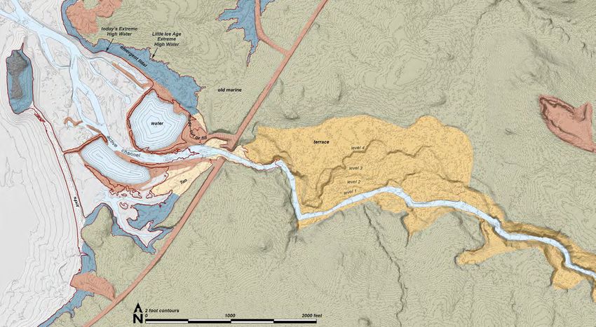
Fish Creek delta on
2013 CBJ LiDAR DEM.
Extreme High Water
(20.8ft) in red.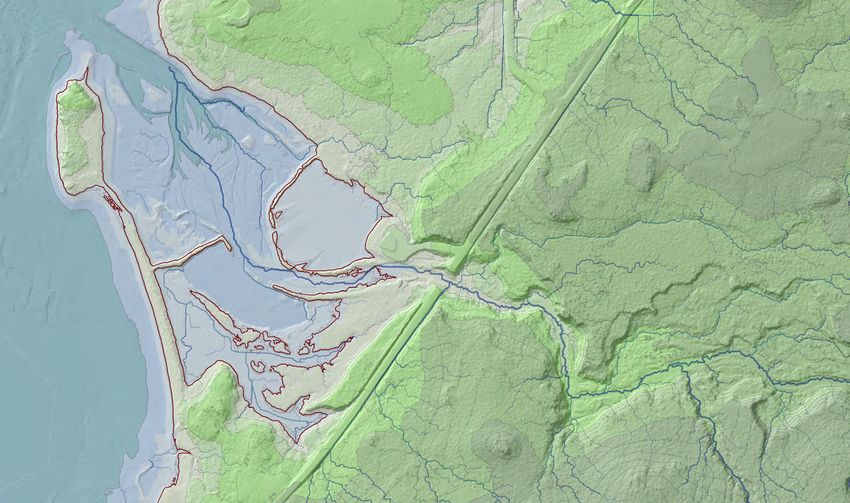
Preface 20200722
In the 'first covid winter,' early 2020, I began talk- Place names convention: In my writing & cartography since publication of Haa
the two projects are quite different. While much
ing with Rob Cadmus and John Hudson at South- has been deleted, even more has been added.
L’éelk’w Hás Aani Saax’ú: Our grandparents’ names on the land (Thornton & Martin eds
east Alaska Watershed Coalition (SAWC) about 2012), I’ve used Lingít place names whenever available, followed by translation in italic,
There are 3 parts to this document:
potential habitat improvements to the delta of Fish and IWGN (important white guy ) in parentheses. Example: Kadigooni X’áat’, island with
1 Scoping contains background materials,
Creek. This has led to a SAWC-DSE collaborative spring water (Spuhn Island). Where Lingít went unrecorded I default to IWGN, and may
and a fairly comprehensive 'bedrock-to-bugs'
study and synthesis for a 194-acre project area, acknowledge its inadequacy with "(noTN?)," Bad news: Lingít toponyms are problematic
natural & cultural history overview for the delta
outlined on the following page. for Fish Creek. Good news: although boring and generic, at least it's not an IWGN.
project area.
For a 2010 trailhead-sign interpretive project 2 Journal entries are field notes from past
with CBJ Parks and Recreation, I started a fairly visits. These are not as geographically exten-
detailed, informal 'scoping document' with field Contents
sive as those in the 'parent' document, which
notes and background materials for the larger Fish includes, for example, upper Fish Creek and
Part 1: Scoping.................................................... 2
Discovery's history on the delta ......................................................2
Creek watershed. Elements of this current docu- Eaglecrest. Cartography........................................................................................4
ment are simply carried over from that earlier one. 3 Appendices include references, corre- Geography & ownership...................................................................7
However the geographic scope, project goals, and spondence, etc.
Bedrock geology................................................................................8
Surficial geology................................................................................9
available resources (eg, LiDAR, new aerials) for Air photo historic series..................................................................14
Vegetational communities...............................................................30
Uplift succession.............................................................................31
Part 1: Scoping Mammals...........................................................................................33
Birds..................................................................................................36
Discovery's history on the delta habitat diversity, and there are few sites in Áak'w
Western toad....................................................................................38
Dredge ponds...................................................................................39
Discovery Southeast (DSE) has a long history at Fish Aaní with a richer assortment in one small area Hydrology and fisheries..................................................................41
Human history..................................................................................43
Creek, beginning with our first natural history programs than Fish Creek delta. Thousands of students have Part 2: Journal entries...................................... 59
at Harborview Elementary in 1989. Of all schools in CBJ
20010112 Mapping for CBJ.............................................................59
learned tracking skills at Fish Creek since our 20090412 Signage scoping ............................................................65
(City & Borough of Juneau), Harborview—our 'birth- first trips here in 1989. 20090419 Photopoint hunt..............................................................73
20091017 Visiting teachers.............................................................75
place'—is most challenged by natural settings for outings 2001 Mapping for CBJ In 2001, CBJ contract- 20100528 Stereo oblique.................................................................78
20100917 Brochure ground-truthing..............................................79
on foot. Fortunately, Harborview's energetic master ed a mapping study from DSE at Fish Creek Natu- 20140509 Fish Creek estuary.........................................................94
20140616 Return to uplift meadow ................................................97
teachers had great parental support, and mobilized car- ral Area Park. I produced map overlays for 1) land- 20150623 Fish delta with GHF .....................................................100
pool expeditions. Fish Creek delta quickly became one of forms (bedrock and surficial geology; 2) vegetation
20150905 Pink spawning ..............................................................101
20190122 Ice coring with SAWC & ADFG ...................................103
our favorite destinations. types; 3) mammals, and; 4) birds. Juneau master- 20190329 Fish delta with SAWC ..................................................103
20200425 Bird-&-toad check ........................................................104
DSE activities are dictated by season. From the begin- birder Paul Suchanec provided a comprehensive 20200805 Metamorphosis ............................................................105
20200818 Dike trail & Salmon Creek ...........................................112
ning, Discovery’s core Nature Studies theme in winter bird checklist for the site. Original report is not 20200819 Honsinger to Sunny .....................................................132
20200906 Sunnyday visit .............................................................142
has been tracking and sign interpretation. Only on snow downloadable, but I incorporated most of it into the 20200915 Fish Creek (& Ditchtrail)................................................143
can we easily track light-footed creatures such as weasel 2010 scoping document described below, and much
20200923 Veg mapping with RC&JH ...........................................144
20210826 Walkthrough focus group ...........................................145
and shrew. Diversity of animal sign correlates with has carried over into this one. Appendices...................................................... 147
References......................................................................................147
2 • Fish Creek delta scoping Correspondence ...........................................................................148
richard.carstensen@gmail.com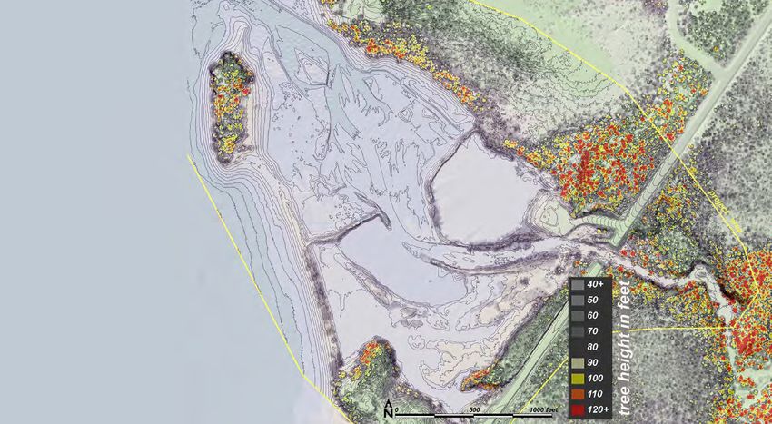
DSE's Diane Antaya, then lead naturalist at Harborview, projected these habitat maps in
her class summary sessions by way of review for tracking field trips. It was a good exam-
ple of the way Discovery links research and education.
   2003 Hotspots study In 2002 and 2003, DSE conducted a year-long study of bird
concentrations on Mendenhall Wetlands for US Fish & Wildlife Service. Bob Armstrong,
Mary Willson and I counted birds at standardized locations throughout the refuge and
marginal lands. Fish Creek estuary was a core 'hotspot' of bird activity. Our work led even-
tually to designation of the Wetlands as a Globally Important Bird Area (IBA). In 2009,
along with writer/editor Marge Hermans Osborn, we published The Mendenhall Wetlands,
a globally recognized Important Bird Area, printed and distributed with funding from
Southeast Alaska Land Trust (SEALT). Although it features birds, this full-color 82-page
book offers the best existing natural history overview of the Wetlands, in which Fish Creek
plays a prominent role.
   2004 SEALT vegetation map In 2004, SEALT, in collaboration with CBJ and
ADF&G, commissioned from DSE a detailed vegetation mapping and analysis of accre-
tion for the entire Refuge and adjacent lands. Primary incentive was better understanding
of how accretion would affect ownership issues along Refuge margins. The project includ-
ed CBJ’s Fish Creek properties. I revised veg-types of my earlier 2001 mapping to fit a
system that more comprehensively describes vegetation throughout the Wetlands. Even
today, 16 years later, this Land Trust map remains the most detailed and complete vegeta-
tion delineation for any Southeast Alaskan tidal marsh, and a model for veg-mapping badly
needed elsewhere.        1

   2007-10 Signs project For CBJ P&R (Parks & Recreation), Discovery created inter-
pretive signs in 10 watersheds including Fish Creek. This CBJ Natural History Project had
3 deliverables: 1) Three-panel trailhead signs. PDF versions of these are available from
JuneauNature. 2) A 76-page guide, Natural history of Juneau Trails, available in local                            Our project area encompasses all but the northeastern portion of
bookstores. 3) Four-fold brochures with maps and interpretive-station notes.                                          CBJ's Fish Creek Natural Area Park, draining into the adjacent
                                                                                                                     'subshed' of 'Sundown Creek.' Although we mostly address the
   An additional, informal product of the signs project were long scoping documents for
                                                                                                                 delta, a short reach upstream of Douglas Highway bridge is includ-
                                                                                                                                        ed for reasons of hydrology and connectivity.
1 Alaska Shorezone is a good system for linear shorelines, but inadequate to description of broader estuaries.

3    •   Fish Creek delta scoping                                                                                                                   richard.carstensen@gmail.com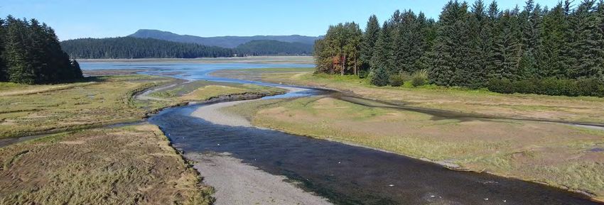
each of the 10 watersheds. The 2009 Fish Creek document was
a full-watershed predecessor to this one that encompasses a
more limited area at stream mouth. It's a pretty rough, 73-page
draft, not downloadable from JuneauNature, but I can share on
request.   2

   2014-15 Wetland surveys For the CBJ's Community Devel-
opment Department (CDD), Teri Camery, lead, we conducted
intensive wetland surveys throughout the borough, in summers
of 2014&15. Koren Bosworth led the field team that included
Catherine Pohl, Andrew Allison, and me. In addition to mapping
of wetland types on Fish Creek delta (right), this project was                                                                  Two-panel map
                                                                                                                            format we evolved for
part of the City's incentive for a 2013 LiDAR mission that has
                                                                                                                            CBJ wetland surveys.
revolutionized cartography borough-wide. This will be central to                                                               Clipped to the PA
the SAWC-DSE assessment of landforms, habitats, and improve-                                                                  boundary (orange),
ment options on the delta.                                                                                                    these wetland units
                                                                                                                            should be extended to
   2016 Supplement On completion of our wetland surveys,                                                                     the rest of the delta.
under separate contract with CDD, I prepared a 512-page refer-
ence document, including photographs and natural history                                                                                                                       2013
"narratives" for each of the ~340 AAs (assessment areas: wetland
units of at least 1 acre), within 72 Priority Areas from Echo                              Cartography
Cove to south Sayéik (Douglas Island). Only the eastern, road-                             LiDAR Greatest advance in mapping since the 2009 precursor to this document has been
proximal portions of our delta project area fell within one of                             acquisition of LiDAR, and its many derivative products. On left in this 2-panel example from
these Priority Areas, so our wetland mapping is incomplete here.                           2013 CBJ LiDAR is a bare earth hillshade from DTM (digital terrain model) that also gave
Completing this—and a more comprehensive mapping of both                                   us a 20.8-foot, Corps-defined Extreme High Water line (blue), which by definition formed the
wetland and upland vegetation—is one objective of DSE's work                               upper edge of our tidal wetland units.
for SAWC.                                                                                    Every 1-m2 pixel on the ground has known elevation, giving unprecedented ability to view
                                                                                           and measure landform features, generate predicted stream channels, or assess relation of
2 The 2009, full-watershed scoping includes many sidebars copied or paraphrased            veg-types to tidal elevation. Although 'first hits' from LiDAR pulses typically encounter tree
from other sources, such as geology papers, fish&game reports, that I've not migrated
into this one unless aimed specifically at the delta project area. More links to related   branches, buildings, etc, these can be removed to give ground surface detail.
resources are in References.                                                                 Point cloud In addition to 'ground returns' for surface detail, the 2013 LiDAR can be
4    •    Fish Creek delta scoping                                                                                                                       richard.carstensen@gmail.com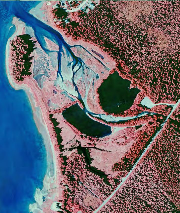
used to display and measure trees
and lower vegetation. Resolution of
8 pts/m2 delivers tree profiles we can
measure to ~1-foot accuracy.
   One of the most useful outputs
from the 'all-hits' point cloud—as                                         Oblique view of
opposed to those edited for only                                            point cloud in
ground returns—is called normal-                                             ArcGIS Pro
ized vegetation in the 2013 CBJ
dataset. The example on right uses
           1

a classification adapted to the range
of tree heights fringing our delta.
Other codings accentuate strata at
the short end for wetlands mapping, or
high end to expedite search for extremely
tall (Landmark-caliber) spruces.
   Drone-based imagery and elevation
models A low-elevation grid flight over the
~190-acre project area can deliver products
similar to plane-based LiDAR missions, but
with considerably more detail. The process, called
SFM (structure from motion) could be thought of
as 'poor-person's LiDAR' in the sense that earth-
elevation models and veg-canopy point clouds can
be generated from a folder of plain old photographs,
without use of expensive and heavy LiDAR sensors. By
triangulation from stills taken at intervals along a flight
1 In more recent missions these layers are more intuitively labeled CHM:
canopy height model.

5   •   Fish Creek delta scoping                                                             richard.carstensen@gmail.com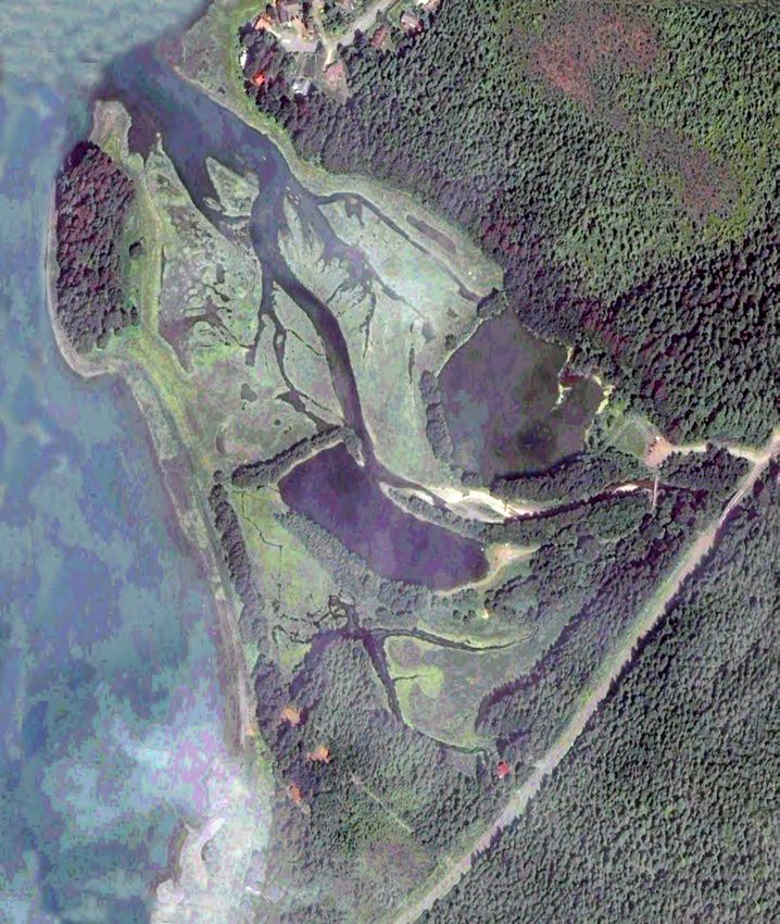
Point cloud generated through SFM (structure from motion)

grid, cloud-based programs deliver hi-res small-area cover-
age with contours, DSMs and .las datasets from which we can
generate treefoliage profiles.
   Stereo 3D stereograms use overlapping portions of two
                  successive images in a flightline. Best view-
                  ing is under pocket stereoscope on a high-
                  resolution tablet. For more casual viewing
                  on relatively low-res computer screens, keep
                  a simple, clear-plastic 1x handheld viewer
                  nearby. Several pairs from historical imagery
                  follow in this document. And of course, super
                 high-res stereo will be available from adjacent
stills in a low-elevation drone survey. For more on stereoview-
ing in vegetation and landform interpretation see JuneauNature
>TOOLS>Photography>Stereophotography.
   Historical series The CBJ Natural History project included
side-by-side vignettes of the delta from 1948, 1962, 1984 and
2003. A more effective way to compare these—expanded now
to 16 different years!—is on successive pages in this pdf, regis-

                                                                           CBJ-WSI
tered for point-to-point comparison, toggling while holding a
pencil to various points-of-interest.                               2013
6   •   Fish Creek delta scoping                                                     richard.carstensen@gmail.com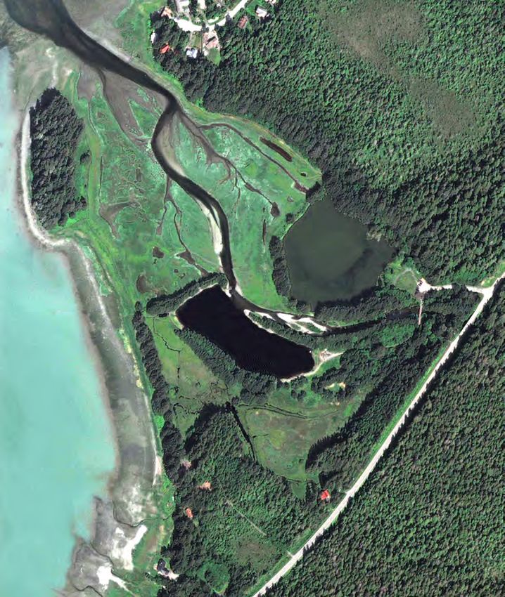
Geography & ownership                                             square miles. In 2014-15, for our CBJ wetland survey project, we created
Fish Creek is the largest stream on Sayéik, spirit helper         finer watershed units from LiDAR and IfSAR elevation models, below.
(Douglas Island), draining an interior basin aligned              Since they were sub-units of USGS Hydrologic Unit Codes (HUCs), we
roughly parallel to the prevailing NW-SE strike of the            refered to these as subsheds. For purposes of our wetlands mapping we
bedrock. All other Douglas streams traverse only short            divided greater Fish basin into 4 subsheds, totaling 13.7 mi2, consider-
distances from ridgetop to saltwater, draining smaller            ably less than the VCU-based total.
basins aligned NE-SW, perpendicular to this regional                 Fish Creek Watershed is mostly owned by CBJ & USFS, who traded a
strike.                                                           parcel on Eaglecrest road to an Angoon family in exchange for lands on
   According to USFS Value Comparison Units (VCUs:                Xutsnoowú. Spit and forested knob enclosing the estuary are State owned
dashed black line below) the watershed covered 14.7               (inset). Private parcels rim shorelines north and south of public lands.

     Ownership in Fish Creek                                Subsheds from our
    watershed and surroundings.                               work in 2014

7   •   Fish Creek delta scoping                                                                           richard.carstensen@gmail.com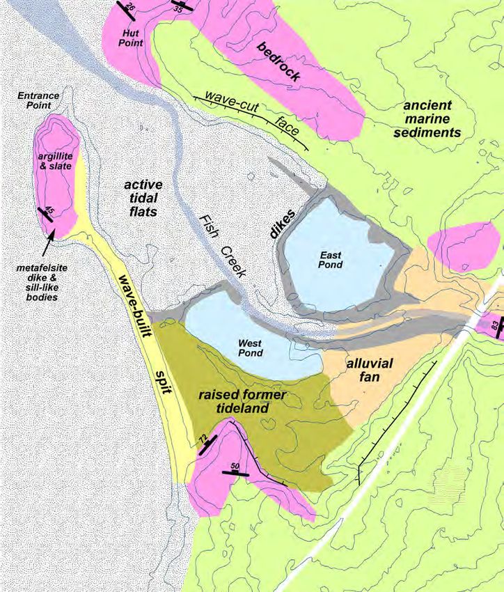
Bedrock codes from 2004 key to USGS layer.
       ● KJgv Volcanic rocks of the Gravina belt (Cretaceous and Jurassic):. Augite bearing flows,
    volcanic breccia, and intercalated tuff, volcanic graywacke, phyllite and slate; andesitic to basaltic
    composition; weathers dark greenish gray; relict augite phenocrysts.
       ● KJg Sedimentary and volcanic rocks of the Gravina belt, undivided (Cretaceous and Juras-
    sic): Mixed and undifferentiated rocks, inter-tonguing of Seymour Canal Formation (KJss) and the
    Douglas Island Volcanics (KJsd); exposed on mainland and Douglas Island Graywacke, dark gray
    slate and argillite (locally calcareous), polymictic conglomerate, fine- to coarse grained volcaniclastic
    rocks and breccia, and augite porphyritic mafic flows. Unit is at least 3000 m thick.
       ● KJgs Sedimentary rocks of the Gravina belt (Cretaceous & Jurassic): In Juneau area,
    graywacke, slate, and minor conglomerate; volcanic debris, except for the conglomerates, which
    are polymictic and contain granitic clasts; most graywacke and slate were turbidites; weathers dark
    greenish gray. Graywacke and slate/argillite are locally calcareous and lighter colored; sedimentary
    structures common. Limestones nodules and lenses to 50 cm thick are common in the argillite. On
    Douglas Island this unit hosts the Treadwell “albite diorite” sill, which is the host rock for the Treadwell
    gold deposits. Unit at least 2500 m thick.
       ● Qa Quaternary surficial deposits: raised former tideland at the mouth of Fish Creek.

Bedrock geology
Fish Creek valley was formed by glacial deepening of less resistant rocks along Fish
Creek fault, which roughly bissects Sayéik, converging gradually with Gastineau fault to
the northeast. Bedrock is actually a more complex mosaic of volcanic, sedimentary and
metamorphic rocks than is suggested by clean boundaries between 3 units on this USGS
layer. Main difference between KJg and KJgs is that the former is “undivided,” ie more
coarsely mapped than the latter, perhaps simply a logistical artifact of reduced acces-
sibility from shorelines.
   KJgs is gold-bearing, and hosts the Treadwell mining complex. KJg was mapped by
Knopf as the auriferous Berner’s Formation, hosting all of the mines in the Peterson
Creek area (Knopf, 1912).
   Connor (2003) synthesized several papers describing the Gravina belt:                                             Bedrock geology of Fish Creek watershed, from draft GIS database
      “Outcropping along North Douglas Highway . . . are late Early Cretaceous (105 Ma) graded                     developed by Sue Karl, USGS, Anchorage, 2007 version. Faults from
      beds of argillite, greywacke, and volcanic ash and flow rocks. These rocks were derived from                                                                Ford & Brew (1973)

8     •    Fish Creek delta scoping                                                                                                                   richard.carstensen@gmail.com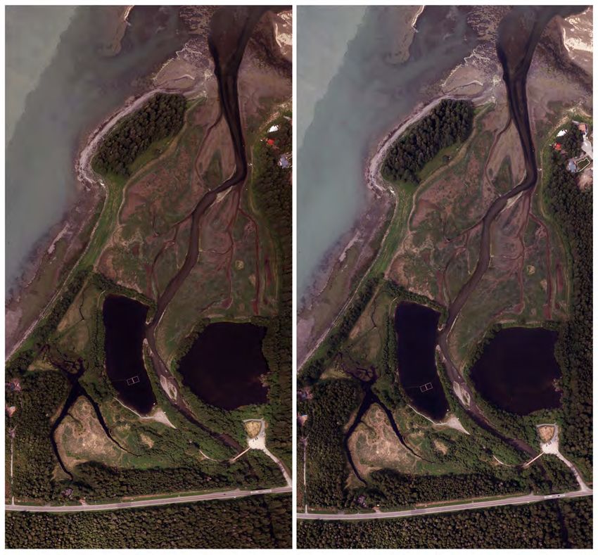
PS: Miller 1975 did not
    augite-bearing basalts in Douglas Island Volcanics formation (135-97 Ma) . . . Mini-                                        show these wave-cut face
    mum age for Gravina strata is from a cross-cutting dike of Treadwell Diorite (91 Ma).                                      symbols, nor do Ford&Brew.
    Along this beach felsic dikes have been intruded between flysch layers.                                                     So where did I get them?!
  Connor (2003) also explained the relationship of Fish Creek fault to the Silver-
bow, which links Sayéik geology (Gravina belt) to that of Taku terrane across the
channel:
    “Ford & Brew (1977) named the geomorphic lineament that defines the Fish Creek
    Valley the Fish Creek thrust. There is no evidence of faulting along this fault to the
    east in road cuts. However, 1 km west of Fish Creek there are 1-2m sections of slightly
    deformed rocks with preserved bedding. . . Intensely asymmetrical folds in foliated
    schistose rocks with slickensides imply a NE over SW shear.
       The Fish Creek fault extends SSE across Douglas and probably continues across
    Stephen’s Passage to Oliver’s Inlet. RD Miller mapped offset in Silverbow fault where
    crossed by Fish Creek fault about 1 mile past Fish Creek bridge along Eaglecrest Road.
    The Silverbow fault is an E-W trending thrust fault that has in turn offset an Eocene
    gold orebody. This structural relationship suggests activity on Fish Creek fault post-
    dates Juneau gold belt ore emplacement in Eocene time. The Fish Creek fault lies sub-
    parallel to the Fairweather, Chatham and Fanshaw faults."
  A local study of metamorphic isograds through the Juneau gold belt (Ford &
Brew, 1973) has considerably more detail than was incorporated into the more
recent Karl 2004 layer. Their map, along with mostly surficial units on right,
shows argillite and slate outcropping at Entrance Point, plus dike and sill-like
bodies of metafelsite at the southern end of that forested knob. Otherwise, there's              Surficial units from
not much bedrock visible on a delta mostly blanketed by marine and alluvial                   Miller (1975); bedrock
sediments, described in the following section.                                                    from Ford&Brew
                                                                                                (1973). Contours 10
Surficial geology                                                                              feet from CBJ's 2001
                                                                                              LiDAR contract. Units
Ancient (early Holocene) marine landforms In 1975, R.D. Miller created an                        traced from these
outstanding map of surficial geologic landforms as part of an earthquake hazards                sources before fine-
study of the Juneau road system (Miller, 1975A). In the course of his work, he                tuning from 2013 bare
became intrigued by the belt of raised glaciomarine terraces surrounding Douglas                   earth, following.

9   •   Fish Creek delta scoping                                                                                        richard.carstensen@gmail.com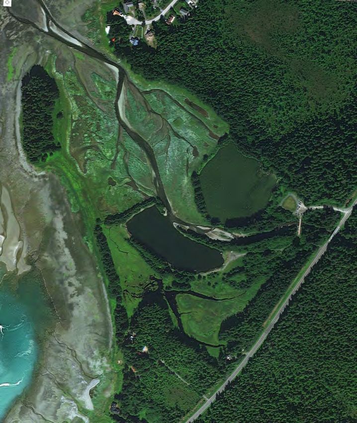
Island, and ended up publishing a paper on what he named the Gastineau                                        tidal deposits (et):
Channel Formation (Miller, 1975B). These are generally fine, poorly drained                                      "cohesive sandy silts with little coarse material . . . surface appears 'swampy' and
sediments laid down 9,000 to 12,000 years ago—after the great ice had                                            when moist, material bends before breaking with subangular or sub conchoidal
                                                                                                                 fractures. [Deposits are] near mouths of streams, [up to] about 30 feet above
melted but while land remained depressed, allowing marine intrusion (green
                                                                                                                 MLLW. . . . Runoff paths form dendritic patterns cut as much as 2 feet into the
on map).                                                                                                         deposits. [overall depth is usually] less than 10 feet thick at most places . . . over
   Marine shells are abundant in these deposits, and their radiocarbon dates                                     younger outwash and deltas.
bracket time period of deposition. 1 Bog and scrub forest on CBJ lands north-                                    While all terrain between 21 and 32 feet is raised former tideland, Miller
west of our project area have developed on these mostly silt-sized sediments.                                 only mapped discontinuous pockets of et at the mouths of larger streams. The
Nothing we currently (202008) envision proposing at Fish Creek delta would                                    patch at Fish Creek on my first tracing (previous page) is about the smallest
take place at the higher elevations of these ancient deposits and landforms                                   he shows. On my revised surf-geo map (next page), I've coded nearly all of
                                                                                                              the 21-to-32-foot belt blue for emergent tidal. In theory, there should be no
Recent (Neoglacial/Little Ice Age) marine landforms Two periods of                                            old-growth trees below maximum Little Ice Age high water.
land depression and subsequent rebound affected deposits on Miller's map.                                        Spit A long, naturally-formed spit on State land connects the Entrance
The first was described above, following the great Wisconsin glaciation; it                                   Point forest to the main island [2020: yellow on my first map; stippled on
involved hundreds of feet of isostatic adjustment. The second corresponded to                                 revised one]. It was built by wave action at peak of the Little Ice Age when
much more recent Little Ice Age adjustments and locally totalled about 11 feet                                relative sea level was higher. Young spruces are slowly colonizing this spit.
of depression and recovery. The land is still rising from that LIA episode, at
                                      2
                                                                                                                 "The largest [spit] deposit is a concentration of pebbles and cobbles that extends
about 0.6 inches per year in this area (Hicks & Shofnos 1968, Larsen et al,                                      outward from the mainland near Fish Creek to Entrance Point, a bedrock prom-
2005). The area coded green on the preceding map, marked raised former                                           ontory. Though mapped as a spit, this deposit forms a barrier beach between the
tideland was intertidal only a few decades ago, but now lies mostly above                                        mainland and point.
extreme high water. [2020: blue et on revised map next page.]                                                        All spits are asymmetrical ridges, generally less than 12 feet high, above mean
   Emergent tidal In his open-file 1972 report, Miller described emergent                                        sea level, that have a steeper landward slope and more gentle seaward slope. Cres-
                                                                                                                 tlines range from a few inches to several feet in width.. . . Thickness of spit deposits
1 My background document for Aak'w, auke-scoping.pdf, has more on these shell collections.                       vary. Some bars on tidal flats are only a few feet thick; others subject to stronger
2 Total post-LIA uplift We arrived at this estimate in 2014 when working with a freshly delivered bare-          currents are larger and thicker. Thickest known— about 16 feet of sandy gravel over
earth hillshade. Throughout CBJ, wave-cut escarpments crest at 32 feet above MLLW (0 ft) according to            bedrock—is in the bar along the south side of Lena Point
fine contours on that model. They were created at time of maximum recent marine intrusion, when the sea              Spits form where tidal shore currents and storm waves move sand and gravel
apparently lingered a bit before retiring, thereby eating away at soft-sand shorelines, most aggressively        laterally alongshore to a jutting point where transfer energy declines, dumping
during gales. I had anticipated these 'intrusion-cookie-cutters' would be slightly higher northward: uplift
rates are faster in Jilkáat Aaní than Áak'w country. But since the 'treads-&-risers' were consistent, we         load. Source is generally streams. Spits erode as well as depositing. Storm waves
used the 32-ft contour to define maximum elevation of raised-tidal wetlands in our mapping for the JWMP.         modify or remove them."
Height above Corps-defined EWHS of 20.8 feet indicates 11 feet of depression (32-21=11), culminating            I'd like to know more about the origins of this spit. Naturalist Greg
probably in the late 1800s.

10     •    Fish Creek delta scoping                                                                                                                               richard.carstensen@gmail.com
Streveler tells me that in Icy Strait there are similar berms that may
have been thrown up during a major storm or storms at peak LIA.
Was this one also formed during a single storm-of-the-century?
Escarpments Annotating my first edition of this map, I
observed (mistakenly?) that Miller's map of showed two small
wave-cut escarpments at Fish Creek estuary with outward pointing
hatchure lines. Although these steep bank, set back a few yards into
young spruce forest, are common features throughout CBJ's more
exposed shorelines, it seemed odd that escarpments should occur
inside the spit-protected inner delta at Fish Creek. I concluded that
these abrupt transitions from former tideland to much older land-
forms could only have been created at a time when the entire delta
11 • Fish Creek delta scoping richard.carstensen@gmail.comwas exposed to wave action, ie, at a time when " . . . are composed of sand and pebbles mixed in varying amounts. [although
the protecting spit did not exist. country rock is metamorphic] granite fragments reflect reworking of upstream
glacial deposits [locally from icefield sources] . . .especially on the fan of
In my 20100917 journal, for pano 16, I
Fish Creek. . . . Almost all fans slope 5o to 10o seaward. . . . Deposits are satu-
searched for a good interpretive station bring- rated below the water table. In deposits of slate fragments, plates or chips lie
ing attention to these escarpments: flat like cards in a deck or are stacked like shingles and inclined against the direc-
" We looked for a station in a 'bathtub-ring' forest, like those so common at Outer tion of flow. Voids between slate fragments are only partially filled by finer material.
Point. Miller maps a wave-cut face in 2 sections of the inner estuary, but on exami- Looseness permits rapid infiltration. 5
nation today they proved not-at-all diagnostic." Streams on alluvial fans are generally confined to a single channel during
Inexplicably, returning to the original Miller map, I can't find these normal flow, but at high discharge channels may shift, be abandoned or flow
hatchured excarpment symbols. So where did I first see them?! 3
through several braids.
Terrace Above the highway, Miller mapped a small polygon of terrace
Alluvial landforms Three alluvial features are shown by Miller in or near deposits, encompassing a 'scarp' symbol similar to my (imaginary?) wave-cut
Fish Creek delta: active channels, fans, and terraces. The first two are recent marine faces.
"Terrace deposits . . .stand above modern alluvium along entrenched channels,
(post Little Ice Age), while terraces were formed in prior millennia of the
lithologically similar but often coarser, and locally rich in granite rocks. . . Those
Holocene. along lower Fish Creek are well-sorted cobble and boulder gravel. Age is late
Channel Miller's map includes narrow yellow strips of active alluvium holocene. . . . Some terrace deposits form 2 or more distinct surfaces separated by
along most of the named streams of Áak'w Aaní. Thanks to 2013 LiDAR bare scarps 1 to 4 feet high. 6
earth model, I was able to trace this channel at much higher resolution. Stream locally are now graded to tidewater. As land rose following the last
Fan About where Fish Creek passes under the highway bridge, it emerges glacial episode, streams cut into their own alluvium.
from former bedrock confinement (now bridge-footing controlled) and Miller was a brilliant geomorphologist, but without access to our LiDAR
spreads out to form an alluvial fan, coded tan on both iterations of my surf- bare earth, couldn't have recognized how extensive and multi-tiered the Fish
geo map. Sorted gravels thus delivered were dredged, as shown in the follow- Creek terrace system has become. On my revised surf-geo map I code these
ing historical series, providing high-quality fill as North Douglas road was
extended. According to RD's 1972 open-file descriptions, fans:
4 material. Ancient (early holocene) raised deltas can provide similar material but these—such as the
foreset beds removed from Home Depo pad and the Costco warehouse district, have mostly been
exhausted, driving the market toward more expensive shot rock, blasted from sites like Stabler's rockpit.
3 Scanning Miller, I see he doesn't use the hatchure symbol at all for relatively small coastal post-LIA
scarps. They're used instead within fairly large ancient (mid-to-early-holocene) alluvial units such as 5 Tallest trees in Áak'w Aaní (aside from colluvial monsters discovered in our LiDAR point cloud) are on
terraces (t), raised deltas (do), and old outwash plains (oo). His only recent landform big enough to earn alluvial fans and floodplains. This is especially true when parent material is Trclt, the goldbelt of limey slate
hatchure step-down lines is Áak'w Táak, inland from little lake (M-word Valley). and phyllite. I've long attributed this to high-carbonate content, but Miller's description of groundwater
(hyporheic) movement is surely also relevant.
4 Due to their high habitat values, it's now mostly illegal to dredge fan or active delta deposits. (SECON
lands up Lemon Creek's 'sacrifice-area' somehow excepted?) But in the 1950s and 60s, as roads and 6 LiDAR bare earth shows these multilevel terraces only in a few places, eg: Fish, Montana and
subdivisions proliferated borough-wide, these were precisely the places targeted for clean, sorted Davies.
12 • Fish Creek delta scoping richard.carstensen@gmail.comwith a mustard color, and mark 4 levels. yin-yangy landforms are typically paired, as when a cross slope
In Appendix 5 of my Supplement to the JWMP (Carstensen, roadbed is cut on the uphill side and filled on the downside.
2016), I've elaborated on biological consequences of alluvial Similarly, as dredge ponds were gouged into Fish Creek
landforms, including these ancient terraces, probably early alluvium, dikes were sidecast to isolate growing pits from
holocene in some cases. On pages 506 and 507, I describe a tidal influence while workers deepened them. Today, these
possible evolutionary pathway for terrace development, using spruce-infested depositional perimeters form a pair of 'spec-
the middle reaches of Fish Creek between Douglas High- tacles' around the northeast and southwest ponds, connected by
way and Eaglecrest Road as case-in-point. In more mature driveways to Douglas Highway. Along with extensions north-
landscapes southward such as the Oregon Coast Ranges, not westward into the tidal marsh, and a 200-foot 'bridging' dike,
'reset-to-zero' by Wisconsin-era glaciation, multi-level terraces fastened to the natural wave-built spit, these built landforms
are the norm in big river valleys. But in heavily reworked are today's lingering culprits in reduced seawater access to Fish
northern Lingít Aaní, they're unusual, restricted to massive Creek delta. Ideas for strategic fill-removal were the initial
raised-deltaic systems that regraded to meet falling sea levels impetus for this SAWC-DSE collaborative study.
through early millennia of the Holocene. Aerials from 1962, below, caught Northeast Pond in the act
of dredging by Joe Smith, a neighbor whom I interviewed while
Built landforms Dating to the early 70s, when "man" was researching the interpretive signs. Joe told me he dug to 50 feet.
a satisfactory stand-in for "person," Miller's map referred to I also learned that Southwest Pond was dredged to 28 feet in
8
anthropogenic features as "manmade." Granted, humans helm- 1972 by Burgess Construction.
ing giant machines were (and remain) predominantly phallus- In the 1984 Thanksgiving day storm, the Southwest Pond
imbued. But a more pc label for the 2020s is simply "built." Terrace evolution. Annotation and dike was breached, and has never since been repaired, in part
Most of RD's mapped "m" features—md, mf, or mw—were commentary in Carstensen (2016). because of the king salmon release-site that was initiated there.
7
depositional, and even these were placed sparingly. Although To some ears (although toads and bats might beg to differ)
published in 1975 when both dredge ponds were present, the Miller map Northeast Pond cries out for a similar undiking.
shows neither. On my revised map, thanks to LiDAR bare earth, it's been
easy to trace both cut and fill—addition and removal—coded brown. These
7 Between the 1972 open-file report and 1975 published map, RD switched mine dump's abbreviation
from md to mm..Small patches were sprinkled from the AJ vomitings upvalley to Perseverance, and at
the Treadwell beachside cave-in. You could think of mms as analogous to the pimply donughts around
a marmot's burrow; ie, no transport farther than a flume can shunt it. RD's mf was reserved for a few
trucked-in surfaces in need of deswampification, such as the Downtown flats and airport runway pads. As 8 Bathymetry so far shows nothing this deep in NE pond. Did Joe's holes gradually (or rapidly) fill in, or
for mw, garbage dumps, I see only: at Lemon, Salmon, and Snowslide Creeks. was his recollection of depth inaccurate?
13 • Fish Creek delta scoping richard.carstensen@gmail.comAir photo historic series
Following vignettes from 16 missions have been georeferenced and presented
1926
on successive pages for toggling in Acrobat (keyboard arrows or mousewheel
US Navy
clicks), while holding a pencil to your monitor at specific points of interest.
1926 US Navy B&W Although I've long used the Navy's 1929 tri-lens air photos
covering much of Southeast Alaska, until recently I assumed the earlier 'pilot-
year' images that happened to include Sayéik had been lost or were gathering
dust, uncataloged, in some federal basement.
John Hudson recently sent me a link to online archives of the 1929 series on
the National Archives. These are grouped into folders by flightline initials A
through Z, and not linked to any photopoint index such as we have for the '29
trilens centerpoints (lavender thumbnail on inset). According to a simple hand-
drawn line index for the prior 1926 mission (lower thumbnail), Sayéik images
were named DI, presumably for "Douglas Island."
On the chance that these 1926 images were tucked alongside the '29s in the
National Archives portal. Cathy suggested I scroll to the bottom of the "D" fold-
ers. Sure enough, there they were, the elusive "DIs." My Historic photo missions
page on JuneauNature links you directly to folders DI-1, DI-2 and DI-3. 1
Comparing this view to 1948, following, shows several changes:
● Building clusters on the '48s were not yet present in '26.
● Dominant channel switched from southern to northern braid. Considerable
migration of secondary channels.
● Small (pre-chainsaw) clearcuts appeared on 2 of the HES parcels
● Crownwidth doubled on 5 stormberm spruces.
3d versions of the
1926 and 1948 aeri-
1 While only 2 of 7 mainland watersheds in the CBJ Natural History Project were covered according to the als are in Human
1929 index, all 3 on Sayéik were captured in the earlier 1926 mission. On this lower flight index for that pilot
history, below.
year, N-S flight lines run across the entire the island. (Other than a few opportunistic obliques, the Navy
extended no farther northwest than M-Valley. Even the glacier is only marginally covered.)
14 • Fish Creek delta scoping richard.carstensen@gmail.com1948 US Navy B&W Tides reached 37 inches higher than today, flooding back
to the outlying spruce. That largest tree with NW-pointing shadow is now the 1948
grove sheltering Discovery's 3-panel interpretive signs. North Douglas Highway
US Navy
had not been built, and access to Fish Creek estuary was only by boat. A mix of
Tlingits and whites was living at Hut Point as reported in Human history, below.
An alluvial fan, or raised delta, distributed sediment from Fish Creek across
the head of the estuary. Distributary channels migrated across its gently convex
surface. Salt tolerant Lyngbye sedges covered the middle reaches of the fan,
grading to bare sand and mudflat about halfway out the estuary. 1
A few spruce saplings were growing rapidly on the wave-built spit, recently
stabilized and now supratidal. On the bedrock knob at Entrance Point, ancient
hemlocks indicate that tide never covered this site, even at peak Little Ice Age
when relative sea level was 11 feet higher.
At estuary's head, below the future road, forest was clearcut sometime since
1926. LiDAR-generated contours indicate slope rises steeply here from 30 to 50
feet. Trees were either yarded down to the estuary and removed at high tide, or
else remained on-site for cabin logs, (several new building clusters since 1926
image) and as firewood for local consumption.
1 I wrote this photo-annotation before acquiring the earlier 1926 aerials. Textural change from salt marsh
down to mudflat is actually easier to detect on the earlier imagery.
15 • Fish Creek delta scoping richard.carstensen@gmail.com1962 USFS B&W Tides reached 28 inches higher than today. This photo shows
a moderately high tide; on extreme high water Fish Creek probably overtopped
1962
its banks and spread into the wetlands on the south side. Fish Creek had been
bridged in 1957.
Joe Smith dredged Northeast Pond to a depth of 50 feet (pers comm: interview
with Laurie Craig). That’s probably his construction camp south of the creek.
Additional dredging took place to the northwest of the pond. It wasn’t apparent
on this high-tide photo, but subsequent shots show this. The 1960s were a time
of rapid development throughout Juneau, with few regulations protecting streams
and coastal habitats. Fish Creek salt marsh was probably buried in new sediment
washed down from dredging activities. 1
Isolated trees separating the southern marsh from raised sphagnum bog were
not naturally dispersed (eg “subforest” responding to natural soil moisture gradi-
ents) but had been selectively logged. The 1948 shot is low-resolution, and it’s
hard to tell if logging had already happened at that time. On my 1948 stereopair
in Human history, below, these scattered survivors can vaguely be detected. This
area can support denser forest, as shown on following aerials from 1984 through
2020.
Several buildings show on private land—HES 119, described in Human
history—south of the wave-built spit. One is right out on the beach—possibly a
boathouse—that was removed by 1979.
1 In several Landmark Trees publications I've written about the dawning realization that, while impacts to
estuaries from logging, dredging and construction may be initially unsightly and even shocking, these systems
are inherently fast-healing. Salt marsh vegetation quickly recolonizes, and overall habitat values, a couple
decades out, may even be higher than they were, pre-disturbance (Example, Fish Creek estuary in Peril
Strait). Problems arise mostly from containment structures such as the Fish Creek dike system, if they isolate
portions of an estuary from saltwater incursion, impede delta-building, or block fish and wildlife access. There
USFS
are winners and losers in all these disturbance-&-recovery scenarios, so our challenge is to prioritize and
weigh predicted outcomes.
16 • Fish Creek delta scoping richard.carstensen@gmail.com1979 NASA This mission covering all of Southeast Alaska was flown from
Lockheed U-2s at 80,000 feet, delivering only coarse resolution for small-area 1979
projects like Fish delta—inch-to-mile on contact prints. But considering that
near-satellite altitude, detail from this flatbed scan is impressive.
Two additional advantages of this imagery:
1) Prints for the CBJ area were acquired at very low tide, probably close to
zero. There appears to be a sudden dropoff about 500 feet out from the enclosing
storm berm. Are these foreset beds at the outer edge of a delta? If so, they'd have
been created at a time before creation of the berm, when a smoothly declining
gradient extended westward from the 'pinchpoint' at today's highway bridge.
2) Color infrared tones, unique to this 1979 NASA mission, picked up differ-
ences in herbaceous communities that are undectectable on true-color images.
Pale pinks here are Lyngbye sedge low-marsh, extending much farther up-delta
than they do today. Even subsequent very high-res CIR acquired by CBJ in 2001
and 2013 fails to capture this important vegetational break—perhaps because
those much lower elevation aerials were flown over a longer period with more
variety of lighting and camera angle.
There was quite a bit of clear water (black in CIR) in the wishbone-shaped
southside sloughs. Comparing to the next image from 1984, water level will be
considerably lower.
NASA
17 • Fish Creek delta scoping richard.carstensen@gmail.com1984 USFS true color Tides reached 15 inches higher than today. The photo
was taken at a moderately high tide. Note the grey, silty water at Entrance Point, 1984
coming not from Fish Creek itself (a non-glacial stream) but back-flushing sedi-
ment into the estuary from Woosh eelʼóox̱ʼu héen, murky river Mendenhall River.
This should remind us that—although local dredging certainly had impacts—the
estuaries of clear-water streams entering Taashuyee (Mendenhall Wetlands) have
always been deluged by “alien sediment,” even more so at times of higher rela-
tive sea level and heavier glacial suspended load.
Southwest Pond was dredged to a depth of 28 feet by Burgess Construction
in 1972. In addition to the dikes containing that pond, a connector dike reached
west to the wave-built spit, effectively isolating the “southern wetlands” from
tidal influence. I haven’t learned why this was done. By the 1984 photo, 12 years
after dredging and dike construction, small alders had begun to colonize distur-
bance sites.
On Thanksgiving Day, 1984, just 3 months after this photo was taken, a severe
storm combined with extreme high tides breached the Southwest Pond containing
dike. It was never repaired.
Residential construction was proceding both north and south of the estuary,
including a pad pushed out into the intertidal at the lower edge of the photo. This
pad still shows clearly on the 2013 LiDAR elevation model. CBJ's parcel layer
has this owned by Dirk Lovig, just south of the Reiswig HES 119 property (side-
bar follows).
Northern fork of the wishbone southside sloughs is almost dry.
USFS
18 • Fish Creek delta scoping richard.carstensen@gmail.com2001 SWCA color infrared Beginning in the late 1990s, Steven W. Carothers
Associates (SWCA, Salt Lake City based) won an Environmental Assessment 2001
contract for Juneau Airport and surroundings. Bob Armstrong and I subcontracted
bird observations, conducted for a year simultaneously with our USFWS refuge-
wide Hotspots study. I trained SWCA's veg-crews and advised on habitat mapping.
They commissioned CBJ's first very high resolution color-infrared photography for
the refuge and adjacent lands. Flown on a bright, high-contrast day, some detail is
lost in tree shadows, but it's otherwise a great resource
PS 2020: When updating my comments under Scoping>Mammals>Beaver,
I became curious about timing and periodicity of occupation in the southside
'Wishbone' sloughs. In the following notes from our maiden wetland surveys, Jour-
nals>20140509, we saw definite active dredging at the east end of north-fork:
"The upper reaches are being deepened by beaver, and the sidecast is very obvious on
both banks." Fresh mud's apparent in panorama 04 from those notes.
I guess I've been assuming that, in addition to canal-deepening, at least some
dam-building was happening, presumably in the area I've marked "control?"
on this 2001 aerial. Flipping through photos in this series, beginning as early as
1979, there are quite a few with fairly wide channels in one or both limbs of the
Wishbone.
But my assumption that channel width was related to degree of beaver mainte-
nance or lack thereof now appears misplaced. On our next visit we need to walk
(or swim?!) the supposed "control" area. I'm guessing we'll find no beaver-towed
branch-dumping here. Contours from the 2013 LiDAR—following with the photo
from that year—don't indicate anything but smoothly north-sloping marsh
SWCA
19 • Fish Creek delta scoping richard.carstensen@gmail.com2005 Google Earth The history slider on Google Earth fills in a few of the gaps
in this series. Every additional photo in a series like this, regardless of how close
2005
it was in time to bracketing images, offers something new. The 2005 imagery
was taken on April 24th at a fairly high tide, and could be used to map the water's
edge contour if we knew precisely what time of day it was taken. Tree shadows
point almost straight north, so it was pretty close to noon.
Spring aerials are revealing of some features that get hidden when herbaceous
and gramminoid meadow rises to full lushness. Along the southside wishbone
sloughs is an olive-green border resembling a wet or greasy 'stain,' seeping into
the fringing peat. My guess is that this pretty clearly delineates the boot-sucking
sphagnum mat that's so tedious to slosh through.
If so, on future tadpole surveys, we should favor the presumably steeper sides
that I've marked with white arrows. Should be easier walking here.
Google Earth
20 • Fish Creek delta scoping richard.carstensen@gmail.com2006 CBJ-commissioned digital mosaic These are the orthoimages I used for
all of the 3-panel interpretive signs commissioned by CBJ Park & Recreation.
2006
Highest tides potentially reached the 20-foot lidar-generated contour. But in 1
reality this rarely occurs in wetlands south of Fish Creek, because of the connec-
tor dike marked on previous 1984 aerial. Sloughs here have minimal salinity and
freeze over in winter. Re-opening this area to full tidal access would enhance its
value to waterfowl in all seasons. 2
On the other hand, the northern half of the estuary is already one of the
highest-value waterbird feeding and loafing areas on the Refuge, year round.
The complex topography with interlacing sloughs and dredged lagoons creates a
diversity of microhabitats, with both low-marsh vegetation and bare sand.
Dikes and former vehicle-disturbed areas are now thoroughly reclaimed by
thickets of mixed alder, willow and spruce, a great addition to the habitat diver-
sity that makes Fish Creek estuary one of the best birding and mammal-tracking
destinations in Juneau. Reforestation also gives cover to black bears accessing
the stream at salmon time.
Northeast Pond had the highest pH we measured (8.8) in hundreds of Juneau-
area ponds during an amphibian study (Carstensen et al 2003). This probably
reflects saltwater influence and fluctuates monthly. What was once a major west-
ern toad spawning site yeilded only sporadic reports at the time of our 2003-05
study. (PS: But it's coming back big-time in 2020!)
1 As previously noted, CBJ commissioned an early LiDAR survey in 2001, when the technology was not yet
so 'seamless' as in the subsequent 2013 mission. For legal purposes, the city's cartography staff considered
this project "provisional," and made little use of it. But I considered it good enough for "naturalist-level
CBJ orthomosaic
handwaving" assessment and description.
2 2020: My thinking on this question of tidal vs supratidal habitat values has changed since the first iteration of
this scoping document in 2009. One factor is toad spawning that now occurs here. This would be eliminated if
tidal access were re-established. Another factor is backwatering of much of the southern wetlands by beaver.
Among many other commensal beneficiaries are huge numbers of mallards, who now have a relatively secure
spring loafing area where dogs can't easily reach them. See Journals>20200425.
21 • Fish Creek delta scoping richard.carstensen@gmail.com2011 Google Earth Here's another view from history slider on Google Earth.
The 2011 imagery was taken mid-day on February 16th, on a falling tide that left
2011
a crisp snowboundary at the 18-foot contour. Table archives predicted a 17.7-
footer at 11:24 AM that day. 1
My notes from the September 2010 walk with Kevin O'Malley describe
the footbridge as "new." Heavy equipment was still on-site at that time (photo
below). Although it looks only partial in this early-2011 aerial, that's just because
the south end is obscured in shadow. Pano 27 in Journal entries>20100917
explains the wide, snow-covered deforested swath on south approach to the
bridge; heavy equipment that bermed up a ramp to this bridge buried brush along
the margins.
Google Earth, 20110216
1 Just found a useful site for
historical tide data that'll be handy for
interpreting historic air photos:
https://tidesandcurrents.noaa.gov/
historic_tide_tables.html
For each year going back to 2008,
you can download a pdf that has tide
station predications for the entire west
2010 coast.
22 • Fish Creek delta scoping richard.carstensen@gmail.com2011 BING This gorgeous imagery has been featured on BING for nearly a
decade; I guess they figure it'd be a shame to replace it with newer stuff. My date
2011
has always been a guess, because BING doesn't provide Y/M/D of acquisition.
It was obviously an autumn view after sedge scenescence—not a a pre-leafing
spring image because alders hadn't dropped their foliage. Scrolling across the
channel into Áak'w Táak, inland from little lake (Mword Valley), cottonwoods
were golden, which I figured would place the photo around late September. Of all
photos in the series, this one had the most crisply delineated sloughs and lagoons.
Boulders had been placed in the parking area, so it was taken after the preced-
ing 20110216 image. On the other hand there's a pile of gravel in that lot, which
had been used up by the June, 2013 ortho, next page. So, either fall 2011 or
2012. . .
After milking Google Earth for historical images, I switched to ESRI's
Wayback app. This is a stand-alone program that doesn't require ArcMap soft-
ware, displaying all orthoimagery that's been used in ArcGIS Online (over popu-
lated areas like the CBJ, AOL updates as often as every 3 years). There's always
a lag between mission-acquisition date and upload to AOL. For example, the
current imagery collected 20190926 was loaded 20200323.
From Wayback I finally learned that this Microsoft imagery was shot on Octo-
ber first, 2011. Resolution is 0.3 meters, with accuracy to 2.72 m of true location.
Microsoft UC-G, 20111001
23 • Fish Creek delta scoping richard.carstensen@gmail.com2013 CBJ-commissioned digital mosaic For our borough-wide wetland assess-
ments beginning in 2014, the city commissioned another aerial mission, acquired
2013
simultaneously with LiDAR described earlier. We received both May (below)
and June (right) imagery, helpful in veg-ID as this spans a significant period in
'green-up phenology.' At 6-inch pixel, these 2013s are by far the most detailed
imagery we currently possess. Of course, a drone mosaic could be still better.
As noted above for the 2001 imagery, the northwestern extent of south-side,
'wishbone' sloughs needs to be investigated for beaver obstructions (and the east-
ern, up-meadow area for bank dens). Below, I've overlaid the May imagery as a
transparency onto bare earth with 2-foot contours. Palest tints are overwintered
thatch from sedges and grasses
2013
contours
2 ft
CBJ, June ortho on bare earth contours
CBJ orthomosaic, June
24 • Fish Creek delta scoping richard.carstensen@gmail.com2013 Digital globe Another one I found on ESRI's Wayback. Taken same year
as our CBJ orthomosaics of May and June, but shot later in the summer at maxi-
2013
mum lushness, July 27th. Resolution 0.5 meter pixel
Interesting 'frosting' effect on the silvery-green Lyngbye sedges is probably
due to the sudden 'layover' phenomenon that you begin to see in the second half
of summer. Swaths of sedges seem to go limp, as if their fibres wilted. Often it
appears as if rogue tidal currents have shoved down patches in random direc-
tions. To me this is emblematic of the 'generosity' of CALY, who 'dissolves' even
before end of growing season, fertilizing its neighboring terrestrial and marine
habitats.
Digital Globe, 20130727.
25 • Fish Creek delta scoping richard.carstensen@gmail.com2016 Google Earth From history slider on Google Earth. The 2016 imagery
was taken on July 16th at a fairly low tide.
2016
Cloud cover made this one hard to adjust aesthetically. But the tidal edge is
crisply defined compared to other images
Google Earth, 20160716
26 • Fish Creek delta scoping richard.carstensen@gmail.com2017-&-18 Digital globe From Esri's Wayback. Spans a seam between two
years. Left-side acquired 20170805; right-side on 20180619. Resolution 0.5
2017
meter pixel and 0.3 meters, respectively.
On the rightside, August 2017 image, there's a distinct 'median strip' running
down both limbs of Wishbone slough that doesn't appear on other aerials (except,
muted, in the previous 2016 view). This is probably the band of floating Sparga-
nium that doesn't reach full cover until well into summer.
Digital Globe, 20170805
27 • Fish Creek delta scoping richard.carstensen@gmail.comYou can also read