RISK CONTROL PRACTICE: EXPOSURE - Falling Aircraft Handbook - JANUARY 2022 - SCOR
←
→
Page content transcription
If your browser does not render page correctly, please read the page content below
JANUARY 2022

RISK CONTROL PRACTICE:
       EXPOSURE
   Falling Aircraft Handbook

         Didier L. SCHÜTZ
   Risk Control Practice Leader,
         SCOR Global P&C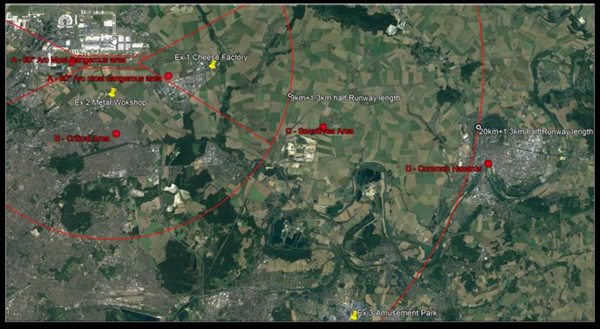
As a founding signatory of the United Nations Environment Programme’s Principles for Sustainable
Insurance, and a member of industry Net-Zero Alliances, SCOR is committed to engaging with
policymakers and other stakeholders to identify and implement the required measures to tackle climate
change. Through the review of our underwriting and investment policies and guidelines and future
targets and commitments under the Net Zero frameworks, we seek to enable and indeed accelerate
society’s shift to a net-zero carbon economy by 2050.

Our conviction is that we have an important role to play in insuring the transition and will actively support
our clients in their own commitments to follow credible transition pathways as they transform their
business model toward net zero.

Disclaimer:

SCOR accepts no responsibility or liability for any use of this handbook by any party to underwrite any
particular risk or to determine an MPL or final loss amount. It is the responsibility of the relevant
underwriter and (re)insurer to independently determine whether to accept, or not, any particular risk
and the contract terms and prices required.

Copyright:

© Copyright SCOR Global P&C SE. All rights reserved. Permission granted to reproduce for personal
and educational use only.
© Google Earth (“copyright fair use”) - Personalized
© Shutterstock: Image(s) used under license from Shutterstock.com
© Didier Schütz - DLS
First edition in 2003.
Client Guidance Note – Falling Aircraft: Support for loss estimate

                                                                        CONTENT
I – EXPOSURE ...............................................................................................................................4

1.      Facts .........................................................................................................................................................4

2.      Airport Types ............................................................................................................................................4

2.1.      Commercial Aviation ...........................................................................................................................4

2.2.      General Aviation ..................................................................................................................................4

2.3.      Military Aviation ...................................................................................................................................5

2.4.      “Mixed” Aviation ..................................................................................................................................5

II – ASSESSMENT ..........................................................................................................................6

1.      Flow Chart ................................................................................................................................................6

2.      Look for nearest airport(s) ........................................................................................................................7

3.      Airport Type & Traffic Pattern ...................................................................................................................7

4.      Airspace Hazard Classes .........................................................................................................................8

5.      Exposure Ranking ....................................................................................................................................9

6.      Relevant MPL Falling aircraft scenario .....................................................................................................9

7.      Airspace B – Critical area inner Airport traffic pattern area ....................................................................10

7.1.      “Extended Primary Surface” around the runway ...........................................................................10

7.2.      Airport flight circuit/pattern extending outside airport perimeters ..............................................11

8.      Risk Management Policy in terms of a Falling Aircraft scenario ............................................................11

8.1.      « First Approach » .............................................................................................................................11

8.2.      “Exposure Ranking” ..........................................................................................................................11

9.      Examples ................................................................................................................................................13

9.1.      Example 1: Cheese factory ...............................................................................................................13

9.2.      Example 2: Metal Workshop .............................................................................................................14

9.3.      Example 3: Amusement park ............................................................................................................15

9.4.      Example 4: Recycling Facility...........................................................................................................15

1.      AIRSPACE..............................................................................................................................................17

1.1.      Special Use Airspace .........................................................................................................................18

2.      Airport traffic Pattern ...............................................................................................................................18

3.      Airport Category .....................................................................................................................................21

                                                                                                                                                                           1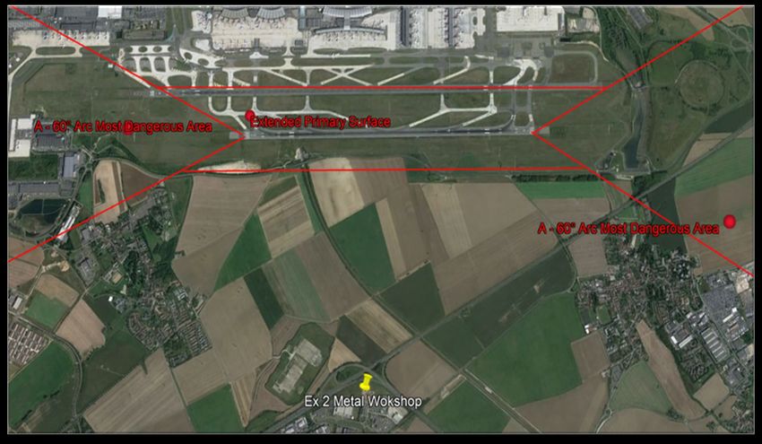
Client Guidance Note – Falling Aircraft: Support for loss estimate

4.      Imaginary Surfaces .................................................................................................................................22

4.1.      Obstacle Limitation Surface (OSL) ..................................................................................................22

4.2.      Missed Approach Surface (MAS) .....................................................................................................24

4.3.      Runway Strip & Runway End Safety Area (RESA) .........................................................................24

5.      “Extended Primary Surface” for MPL purposes:.....................................................................................24

6.      Aircraft Accidents causal Chain ..............................................................................................................25

7.      Most Hazardous Phases of Flights .........................................................................................................26

8.      Mid-Air Collision ......................................................................................................................................26

9.      In-flight Break-up ....................................................................................................................................26

10.     Weak Turbulence ...................................................................................................................................27

11.     Bird Hazard .............................................................................................................................................27

12.     Minimum Safe altitude ............................................................................................................................28

12.1.     General ................................................................................................................................................28

12.2.     Rules for overflying built-up areas ..................................................................................................29

13.     Emergency Landing ................................................................................................................................29

13.1.     Basics..................................................................................................................................................29

13.2.     Accuracy Landings ............................................................................................................................30

13.3.     Emergency Landing Procedures ......................................................................................................30

V – Support for Recommendations ............................................................................................31

VI – Aviation Loss Record ..........................................................................................................32

1.      2007 Domestic airport located in a major city - crash landing................................................................32

2.      2006 Regional Airport – crash on Terminal after take-off ......................................................................32

3.      1999 iNTERNATIONAL aIPORT on seashore – crash landing .............................................................32

4.      2002 - Mid- air collision...........................................................................................................................33

5.      2001 - weak turbulence after take-off .....................................................................................................33

6.      2001 - Terrorist Hijack and deliberate crash into High-Rise buildings ...................................................33

7.      2000 - crash after take-off ......................................................................................................................34

8.      1992 - crash after take-off ......................................................................................................................34

9.      1991 – in-flight break-up .........................................................................................................................35

10.     1989 – Crash landing .............................................................................................................................35

                                                                                                                                                                       2
Client Guidance Note – Falling Aircraft: Support for loss estimate

SCOPE
The purpose of this Handbook | Guidance Note is to provide comprehensive technical support to
underwriters, risk control engineers and Risk Managers when assessing falling aircraft exposure for a
given property risk.
Although this Handbook | Guidance is detailed and deals with a number of perils and potential scenarios,
it is not intended to be a comprehensive analysis of every peril and potential scenario an underwriter may
be requested to provide cover for. Any estimation or projection of an MPL and final loss amount must be
based on reliable, accurate and current values, applicable scenarios, and consideration of the relevant
perils.

This document complements the MPL handbook providing technical data justifying the falling aircraft loss
estimate scenario in case of relevant exposure. Please refer to the MPL handbook for loss estimate rules
and methods.
Only those hazards relating to the standard and emergency operating conditions of aircraft have been
taken into consideration. For deliberate action such as terrorist attacks please refer to the MPL handbook
(Falling aircraft section, terrorism case sub-section).
The first version of this document was released in May 2003 and updated in 2007 and 2012. This 2022
version considers the latest data from air transportation safety information and available loss records when
relevant.

ACKNOWLEDGMENTS
Many thanks to the following people for their invaluable and extensive contributions:

    •    Pilots, air traffic controllers, flight instructors, flight examinators and air safety investigators
    •    Nicole Jamieson, Conference Interpreter (AIIC)
    •    Franck Orset (FPO), Loss Prevention Engineer – drawings and more

                                                                                                                3
Client Guidance Note – Falling Aircraft: Support for loss estimate

I – EXPOSURE
    1. FACTS

Air disasters are relatively rare events.
Falling aircraft impacting a property risk is also a rare event.
People and organizations tend to ignore low frequency, high impact events until they actually happen
(common behavioural risk bias).
The following conclusions issue from accident reports, near miss investigations and statistics regarding air
transportation.
    •    For a given property risk located in a given area, the hazard of falling aircraft can exist.
    •    However, falling aircraft exposure is not the same for all properties.
    •    Exposure is greater within the vicinity of an airport.
    •    Commercial aviation (e.g. airliners) is responsible for high severity property losses.
    •    General aviation (e.g. recreational, corporate) is responsible for relatively low severity property
         losses.
Based on the above let’s focus on critical areas around the airport. This relates to the type of aviation and,
therefore, the aircraft involved as summarized below.

    2. AIRPORT TYPES

     2.1.     Commercial Aviation

The purpose of this Handbook | Guidance Note is to provide comprehensive technical support to
underwriters, risk control engineers and Risk Managers when assessing falling aircraft exposure for a
given property risk.
Commercial aviation mainly involves jet/propeller-driven airliners for passenger and/or freight
transportation as well as certain business/corporate aircraft and government aircraft.
Commercial aviation aircraft are mainly operated on an Instrument Flight Rules basis consisting of
stipulated flight procedures for navigating aircraft by referring to cockpit instruments and radio navigation
aids alone, regardless of visibility. The majority of commercial cruising aircraft are controlled by automatic
pilot. More than 30% of the approaches and landings of commercial aircraft are currently processed
automatically. In the near future, this will increase with the development and installation of modern
navigation systems. Anti-collision systems are also frequently used.
Key points for the proper and safe operation of commercial aviation are:
    •    Aircraft reliability (regular, specialized maintenance, flight systems/engine redundancies);
    •    Adequate flight crew training.
    •    Efficient Air Traffic Control.
    •    Proper maintenance of runway(s) and related critical facilities.
In airline operations today, a single isolated event rarely results in an accident. Rather, a chain of events
develops that changes what may have been an uneventful flight into a disaster. If events had been different
at any one link in the chain, the accident may never have happened.

     2.2.     General Aviation

General aviation mainly involves recreational aircraft as well as certain business/corporate aircraft for
passenger transportation /aerial work and flight instruction aircraft.
Most business/corporate aircraft are equipped with autopilot and instrument navigation systems for flying,
regardless of visibility. In such cases, a flight plan including specific information relating to the intended
flight of an aircraft is completed orally or in writing, with Air Traffic Control.

                                                                                                           4
Client Guidance Note – Falling Aircraft: Support for loss estimate

Recreational aircraft (private pilots, instruction) mainly operate on a Visual Flight Rules basis consisting of
stipulated flight procedures for the visual navigation of aircraft, clear of cloud, in visual meteorological
conditions. The flight itinerary and cruising altitude are not subject to a flight plan (free style flying according
to Visual Flight Rules) except when flying above dangerous or specific areas.
The key points for proper and safe operation of general aviation are:
    •    Aircraft reliability (regularly approved maintenance, single engine reliability, quality of fuel);
    •    Proficient pilot training.
    •    Adequate auto-information between pilots or Air Traffic Control (if any).
    •    Proper maintenance of runway(s) and related critical facilities.
Most general aviation accidents are reportedly the result of human factors (action or inaction on the part
of the pilot-in-command which is normally referred to as “pilot error”). The seasonality of flights plays a
major role. Spring and summertime are known as high season in the northern hemisphere and more flights
and more accidents are usually reported.

     2.3.     Military Aviation

Military aviation involves jet fighters and jet/propeller-driven cargo aircraft for freight and trooper
transportation, refuelers and or civil airplane types used for VIP transportation (e.g. Air Force One).
The potential for falling aircraft around a military airport is similar to that around a commercial airport.
Military cargo aircraft operations are similar to those for commercial aviation, including advanced
navigation instrument systems and anti-collision systems.
Jet fighters normally fly in restricted areas at a sufficient distance from urban areas. Training includes low
altitude and high-speed flights in adverse meteorological conditions. Mid-air collisions with recreational
planes have been recorded. Special attention should be paid to training areas and ground structures used
as visual markers or targets (chimneys, plants, etc.) for jet fighters.
The key points for the safe and proper operation of military aviation are similar to those for commercial
aviation. Consequently, in this document, please refer to commercial aviation operations for an
assessment of exposure in military aviation operations.

     2.4.     “Mixed” Aviation

                                                                              Some airports may include two or
                                                                              more of the above aviation types.
                                                                              In such cases the exposure
                                                                              assessment should be conducted
                                                                              on the basis of the highest
                                                                              exposure (i.e., commercial /
                                                                              military airport).

                                                                                                                 5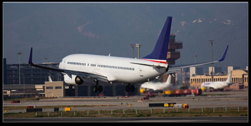
Client Guidance Note – Falling Aircraft: Support for loss estimate

II – ASSESSMENT
    1. FLOW CHART

In this section, a comprehensive methodology is proposed for assessing falling aircraft exposure and
calculating the Falling Aircraft MPL in the case where exposure is relevant. The proposed falling aircraft
assessment methodology is based on air transportation safety information applied to property risks.
However, for easier understanding and in order to ensure the straightforward usage of this tool, special
efforts have been made to use understandable non-specialized aeronautical terms and data for each step
of the assessment process.
The Falling Aircraft exposure assessment process is summarized in the following flow chart. Assessment
should be implemented, step by step:

    .

                                                                                                       6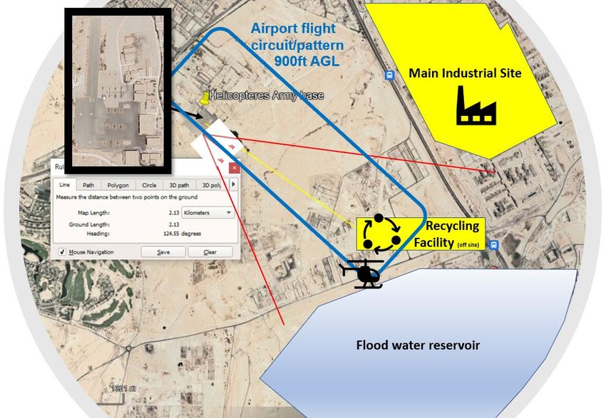
Client Guidance Note – Falling Aircraft: Support for loss estimate

    2. LOOK FOR NEAREST AIRPORT(S)

    •    Look for nearest airport location (flying distance using road atlas, travel guide, geo-software, etc.)
    •    Indicate direction to airport (NE, SE, NNW, etc.,).
    •    Define if plane is overflying the risk (during a visit on-site or in a report) and direction & angle of the
         runway axis.

    3. AIRPORT TYPE & TRAFFIC PATTERN

    •    Define Airport Type as follows:
         - Commercial aviation (international / domestic airport)
         - General aviation (recreational airfield, private jet airstrip)
         For a given airport, consisting of both commercial and general aviation airport activities, consider
         commercial aviation only.
    •    Define runway orientation and length (*) (e.g. using Geographic Information System).
    •    Define air traffic patterns: draw the Inner & Outer Airport Traffic Pattern Circle as follows

                                                                                                                 7
Client Guidance Note – Falling Aircraft: Support for loss estimate

    •    Define traffic patterns: draw the Inner (radius r) and the Outer (radius R) airport Traffic pattern circle
         as follows:
         - For commercial aviation: r = 9km/5.6mi & R = 20km/12.4mi from center of runway + half runway
             length (*)
         - For general aviation: r = 5km/3.1mi & R = 10km/6.2mi from center of runway + half runway
             length (*)
         (*) Half runway length: the “Displaced Portion of Runway” (if any) is excluded from the runway
         length. The displaced portion of the runway shown in black with white arrows below is immediately
         to the left of the threshold marked with eight white blocks in two groups of four. The displaced
         portion of the runway may be used for take-off but not for landing. After landing at the other end,
         the landing aircraft may use the displaced portion of the runway for roll out.
         Displaced Portion of Runway

    •    Please refer to the airspace classes diagram (section 2.4) to locate the risk.

    4. AIRSPACE HAZARD CLASSES

    •    Draw the 60° arc: 30° on both sides of the runway axis starting at the runway end (Displaced Portion
         of Runway excluded – see section 3 bellow) and extending up to the Inner Traffic Pattern area
         circle (in case of multiple runways e.g. Charles de Gaulle Airport, London Heathrow, JFK, this
         should be done for each and every runway).
    •    Plot the Airspace Classes (note that these classes are not official aviation terms. These Airspace
         Classes are Risk Control terms used for Falling Aircraft exposure assessment).

                                                                                                                8
Client Guidance Note – Falling Aircraft: Support for loss estimate
5. EXPOSURE RANKING
• Locate the risk in the following traffic airport airspaces A, B, C and D (section 2.4 above)
• Use the following table for establishing the Exposure Ranking
Airport Traffic Airspace Description Potential Hazard Area Exposure
Pattern Circle & Operations and Consequences Ranking
Most dangerous area -Plane crash due to major
Inner Airport traffic pattern area engine failure and emer-
– 60° arc: gency landing 5- Very High
A ⋅ Take-off / initial climb (Relevant Falling Aircraft
⋅ Final approach / landing ⋅ Or plane break-up due to MPL scenario)
weak turbulence
Critical area 4- High
Inner Airport traffic pattern area: (Relevant Falling Aircraft
⋅ Vertically above & below MPL scenario especially,
B runway but not limited to facilities
⋅ Crash due to major
⋅ Airport circuit inside airport perimeter)
engine failure and
unsuccessful accuracy in
Sensitive area emergency landing
C Outer airport traffic pattern area 3- Moderate
Common hazards area ⋅ Or Disintegration and
Common traffic pattern area: falling debris 2- Light
D ⋅ Airways connection
⋅ Airways 1- Very Light
6. RELEVANT MPL FALLING AIRCRAFT SCENARIO
A falling aircraft MPL scenario, for a risk with an exposure ranking of 5-Very High, is deemed relevant for
the following reasons:
• Exposure ranking 5-Very High means an area where major engine failure, at relatively low altitude,
gives the aircraft crew a very short time in which to react, organize and proceed with an emergency
landing, whilst taking altitude, runway availability, obstruction and a safe landing area within a 60°C
arc ahead of the plane into consideration. The crew must make split-second decisions. Under such
conditions, there is no guarantee that the crew can direct the plane to the spot which may offer the
best chances for an emergency accuracy landing, limiting damage to both aircraft and ground
installations.
• Weak turbulence, due to other planes during take-off, may be responsible for aircraft break-up
when a safe distance between aircraft is not respected. Due to the relatively low altitude in class A
airport airspace, substantial falling debris resulting from aircraft break-up may severely damage
ground installations.
See MPL Handbook section ‘Falling Aircraft’- general case, high rise building case and airport case
depending on aviation type (i.e. general, commercial).
In other areas, with lower exposure ranking from 1 to 4, the following points should be considered in detail:
• Potential for Falling Aircraft cannot be totally excluded. (Zero risk concepts do not apply).
• In the case of major engine failure, the crew has more time to get organized and proceed
accordingly with an emergency accuracy landing in an open area without any obstruction,
mitigating exposure to existing ground structures.
• Aircraft break-up due to weak turbulence is not as common in such areas. However, in the case of
weak turbulence, due to relatively high altitude, the aircraft will break up into relatively small debris
such as an engine. The most likely maximum potential hazard to ground installations may result
from an engine falling onto a given risk.
9Client Guidance Note – Falling Aircraft: Support for loss estimate
• Consequently, for a risk located in lower exposure ranking areas (1 to 4), after applying aggravating
/ mitigating factors when using the Risk Ranking method, the MPL scenario should mainly focus
on inherent hazards, other surrounding exposure or natural perils.
7. AIRSPACE B – CRITICAL AREA INNER AIRPORT TRAFFIC PATTERN AREA
Airspace B includes the following areas where a potential Falling Aircraft scenario should be considered
for a given facility:
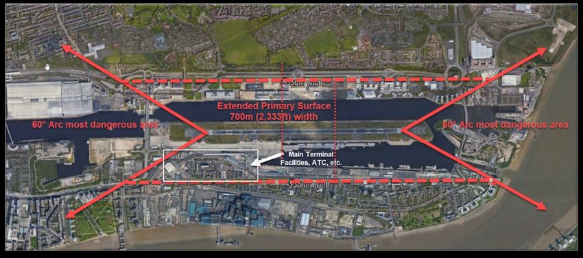
7.1. “Extended Primary Surface” around the runway
• Distance (measure on all sides of runway):
- 350m/1148ft for commercial aviation (international / domestic airport) or military airport with
aircraft of a similar size to commercial aircraft
• 175m/574ft for general aviation (recreational airfield, private jet airstrip)
- extending beyond either end of the runway and connecting with the 60° arc
In the case of multiple runways with different orientations, all the most dangerous areas for all the runways
should be considered.
For terminals, control towers, support buildings (i.e. utilities, maintenance, fuel supply, catering, customs,
luggage handling, ground vehicles, etc.), hangars, parking lots and any third party facility (if any) located
inside this “Extended Primary Surface” (Airspace Class A and B) a plane crash over those structures
should be considered. This is a relevant Falling Aircraft MPL scenario.
The MPL should be calculated as per the MPL Handbook, general case and/or High-rise Building case
(warning: different scenarios for commercial aviation and general aviation # MPL fire).
Example of “Extended Primary Surface” for commercial aviation (international / domestic airport) or military
airport with aircraft of a similar size to commercial aircraft):
• Example below shows an International airport with a single runway for which all critical facilities are
located inside the Extended Primary Surface (thus exposed to a Falling Aircraft scenario inside the
airport perimeter):
Source of background image: Google Earth (“copyright fair use”) - Personalized
See section 3 for more explanation about the origin of the “Extended Primary Surface”.
10Client Guidance Note – Falling Aircraft: Support for loss estimate
7.2. Airport flight circuit/pattern extending outside airport perimeters
• This is on a case-by-case basis.
• A Falling Aircraft scenario should be considered for facilities located outside airport perimeters
located under the airport flight circuit/pattern when known (e.g. New York JFK – AA Airbus, 12 Nov.
2001). Exposure deemed as “High”.
• When the exposure is known and confirmed, the Falling Aircraft MPL scenario should be
calculated. See MPL Handbook section ‘Falling Aircraft’, general case, high rise building case
depending on aviation type (i.e. general, commercial).
• When no exposure is reported (facilities located outside airport perimeters and NOT located under
the airport flight circuit/pattern) the exposure can still be considered and investigated in a Risk
Management policy (e.g. “First Approach” or “Exposure Ranking”).
• See chapter IV for more explanation about airport flight circuit/pattern.
8. RISK MANAGEMENT POLICY IN TERMS OF A FALLING AIRCRAFT SCENARIO
Some Risk Managers consider that all facilities located within a distance of 20km/12.4mi (regardless of
Airspace) of a major commercial airport may be exposed to a plane crash.
As proposed in this handbook a so called “First Approach” or “Exposure Ranking” may be considered for
assessing their exposure based on a Falling Aircraft scenario as follows:
8.1. « First Approach »
As per the Risk Management policy any facilities located within 20km/12.4mi of a major commercial airport
(regardless of Traffic Pattern or Airspace Classes - calculated from runway end + half runway length) is
deemed as potentially exposed to a plane crash.
See MPL Handbook section ‘Falling Aircraft’, general case, high-rise building case and airport case for an
MPL Falling Aircraft scenario depending on aviation type (i.e. general, commercial).
8.2. “Exposure Ranking”
As per the Risk Management policy any facilities located within a distance of 20km/12.4mi (regardless of
Airspace classes) of a major commercial airport AND having an exposure rank of 5 is potentially exposed
to a plane crash.
The basic Area Exposure Ranking of the facility depends on the Traffic Airport Airspace (B, C and D only)
and their corresponding Area Exposure Ranking (i.e. B: 4-High; C: 3 -Moderate; D: 2- Light or 1- Very
Light).
Then potential aggravating and mitigating factors can be considered as follows:
Potential Aggravating Factors:
Dedicated for Airspace B, C and D only.
One or more of the following aggravating factors can be considered as follows:
11Client Guidance Note – Falling Aircraft: Support for loss estimate
Exposure Ranking
Aggravating Factor
Increase
Traffic Path Factor:
For an airport with aircraft (of whichever type), flying over the risk +1
(e.g. relatively low altitude etc.).
And /or
Aircraft Type Factor:
For an airport with heavy carrier long-range jumbo jets (A380, B747,
A340) and regional/domestic airliners carrying 80 or more +1
passengers (B737, A330, MD80)
flying over the risk
And /or
For any other special reported conditions:
Such as a temporary flight path of special cargo above a given risk,
+1, +2, +3 or +4
significant crash history reported, extensive temporary jet fighter
training, military refueler plane, etc.,
Potential Mitigating Factors:
Warning:
• The use of mitigating factors should be restricted to cases where reliable information and data are
available.
• Mitigating factors do not apply for risks located in airspace A areas (most dangerous area – 60° arc
or airspace B without data about runway orientations)
Only one of these mitigating factors can be considered as follows:
Exposure Ranking
Mitigating Factor
Decrease
For risks located in the airspace D (Common traffic area) or
airspace C (Outer airport traffic area):
Risk located in a large open area (rural area with small built-up areas
less than 1,200m/3937ft in mean width) without any obstruction -1
(a lot of fields and small villages) allowing the crew to organize and
proceed accordingly with an accuracy emergency landing.
Or
For risks located within the airspace C (Outer airport traffic area)
or airspace B (Inner airport traffic area):
Risk located in an area where flying over is prohibited unless the
-1
altitude is safe, sufficient for a plane losing power above the city to
glide outside the city limits and prepare for an emergency landing.
Resulting Ranking:
• For a given facility with an exposure ranking of 5: See MPL Handbook section ‘Falling Aircraft’,
general case, high-rise building case and airport case for MPL Falling Aircraft scenario depending
on aviation type (i.e. general, commercial). (same as section 2.6 above)
• For a given facility with an exposure ranking between 1 and 4: No relevant Falling Aircraft scenario
foreseen subject to the risk management policy.
12Client Guidance Note – Falling Aircraft: Support for loss estimate
9. EXAMPLES
All given examples 1, 2 and 3 are located within the Inner and Outer airport traffic pattern circles of an
international commercial airport as shown on the sketch below.
Int’l airport
Ex 1. Cheese Factory
A-Most dangerous area
Ex 2. Metal Workshop
C-Sensitive area
B-Critical area
D-Common hazards area
Ex 3. Amusement Park
Source of background image: Google Earth (“copyright fair use”) – Personalized
9.1. Example 1: Cheese factory
A 60,000m² surface area multi-location cheese factory located east of the airport.
Nearest airport location and direction:
• End of southern runway 26L of the international airport situated 4km/2.5mi to the west.
Airport type and traffic pattern:
• The international airport is used for commercial aircraft (international / domestic).
• Airspace B of 9km/5.6mi + half runway length and Airspace C of 20km/12.4mi + half runway length
to be considered from the center of runway for the international airport southern runway 08R-26L.
Runway orientations for the international airport are indicated on the map. The 60° arcs were drawn
on the map for the southern runway 08R-26L. Planes from the international airport are reportedly
flying right over the risk.
Airspace classes & exposure ranking:
• The risk is located in the airspace A of the international airport (60° most dangerous area).
• The exposure ranking is 5- Very High
MPL Falling Aircraft:
• A relevant Falling Aircraft MPL scenario is considered.
• See MPL Handbook section Falling Aircraft, commercial aviation, general case.
13Client Guidance Note – Falling Aircraft: Support for loss estimate
9.2. Example 2: Metal Workshop
A 45,000m² surface area, 2 stories high (6m/20ft) mono-bloc metal workshop located south of the
international airport.
Nearest airport location and direction:
• Southern runway 26L of the international airport situated 2.2km/1.4mi to the north.
Airport type and traffic pattern:
• The international airport is used for commercial aircraft (international / domestic).
• Airspace B of 9km/5.6mi + half runway length and Airspace C of 20km/12.4mi + half runway length
to be considered from the center of runway for the international airport southern runway 08R-26L.
Runway orientations for the international airport are indicated on the map. The 60° arcs were drawn
on the map for the southern runway 08R-26L.
• Planes from the international airport are reportedly flying right over the risk.
Airspace classes & exposure ranking:
• The risk is located in the airspace B of the international airport.
• The exposure ranking is 4- High
MPL Falling Aircraft:
• A potential Falling Aircraft MPL scenario should be investigated as follows:
• The risk is outside the “Extended primary surface” as shown below:
• Risk facilities are reportedly located outside airport perimeters but located under the airport flight
circuit/pattern.
• As a result, a relevant Falling Aircraft MPL scenario should be calculated. See MPL Handbook
section’ Falling Aircraft’, commercial aviation, general case.
Source of background image: Google Earth (“copyright fair use”) - Personalized
14Client Guidance Note – Falling Aircraft: Support for loss estimate
9.3. Example 3: Amusement park
A multi-location (low-rise and high-rise buildings) complex (3.4km2/340ha) located inside the limit of the
airspace C (20km/12.4mi + half runway length) to the south east of the international airport.
Nearest airport location and direction:
• Southern runway 26L of the international airport situated 20km/12.4mi to the north west
Airport type and traffic pattern:
• The international airport is used for commercial aircraft (international / domestic).
• Airspace B of 9km/5.6mi + half runway length and Airspace C of 20km/12.4mi + half runway length
to be considered from the center of runway for the international airport southern runway 08R-26L.
Runway orientations for the international airport are indicated on the map. The 60° arcs were drawn
on the map for the southern runway 08R-26L.
• Planes from the international airport are reportedly NOT flying over the risk.
Airspace classes & exposure ranking:
• The risk is located in the airspace C of the international airport.
• The exposure ranking is 3- Moderate
MPL Falling Aircraft:
• No relevant falling aircraft worst case scenario foreseen
• However, the exposure can still be considered and investigated in a Risk Management policy as
follows:
“First Approach”: See MPL Handbook section ‘Falling Aircraft’, general case, high rise building
case for commercial aviation.
OR
“Exposure Ranking”:
- No obvious aggravating factor reported
- Mitigating factor (-1) Risk located in a large open area (rural area with small built-up areas
less than 1200m/3937ft in mean width) without any obstruction (a lot of fields and small
villages) allowing the crew to organize and proceed accordingly with an accuracy
emergency landing.
- Resulting Exposure Ranking is 2 – Light
- NO Worst-case Falling Aircraft scenario considered
9.4. Example 4: Recycling Facility
A Recycling Facility (off site – remote from the main site) owned and operated by a large industrial site.
This Recycling Facility is critical for the industrial site - part of its Environmental, Social and Governance
(ESG) commitment - and is occupied for the treatment of process wastes (metal and organic compounds
removal). About USD 60M investment, single location (low-rise, 8m high, chimney stack, reactor, rotary
kiln) located inside the airspace A (most dangerous area) of a military airport.
Nearest airport location and direction:
• Runway 13-31 of a military airport situated 2.13km to the north-west of this recycling facility
Airport type and traffic pattern:
• Army airport mostly used by large military helicopters and some vertical and/or short take-off and
landing (V/STOL) aircrafts (airplanes able to take-off or land vertically or on short runways).
15Client Guidance Note – Falling Aircraft: Support for loss estimate
• Airspace - inner airport traffic pattern area – 60° arc: take-off / initial climb and final approach /
landing. The 60° arc facing the Recycling Facility was drawn on the map for the runway 13.
• Aircrafts from the military airport are reportedly flying over the risk (airport flight circuit/pattern) at
relatively low altitude (i.e. 500ft).
Left hand side: Helicopter launch Flickr - CC Creative Commons license - Attribution 2.0 Generic (CC BY
2.0). Right hand side: V/STOL 0050 Osprey © Evelyn Simak. Geograph Britain and Ireland Attribution -
CC Creative Commons license - ShareAlike 2.0 Generic (CC BY-SA 2.0).
Airspace classes & exposure ranking:
• The risk is located in the airspace A of the military airport and right below the airport flight
circuit/pattern.
• The exposure ranking is 5- Very High
MPL Falling Aircraft:
• Relevant falling aircraft worst case scenario foreseen.
16Client Guidance Note – Falling Aircraft: Support for loss estimate
IV – SUPPORT FOR ASSESSMENT
The purpose of this section is to provide an overview of air traffic operations, related hazards, safeguards
and comprehensive data regarding Falling Aircraft exposure and assessment.
1. AIRSPACE
Airspaces have been created in order to protect IFR flights (Instrument Flight Rules - mostly commercial
airliners operating on autopilot or on manual mode using instrument guiding systems). In these airspaces,
the traffic is controlled by Air Traffic Controllers. These controlled airspaces include airways (AWY-radio
navigation systems), Terminal Areas (TMA – intermediate phase of IFR flight) and Control Terminal
Regions (CTR – approach and departure from airport), as follows:
When policy makers decide to remove life safety and property protection provisions from codes, they have
substituted politics for technical requirements that were determined after extensive input from across the
spectrum of knowledgeable people.
AWY
TMA
CTR (CTR)
AWY: An airway or air route is a defined corridor that connects one specified location to another at a
specified altitude along which an aircraft that meets the requirements of the airway may be flown. Airways
are defined with segments within a specific altitude block and/or corridor width, and between fixed
geographic coordinates for satellite navigation systems or between ground-based Radio transmitter
navigational aids (navaids; such as VORs or NDBs) or the intersection of specific radials of two navaids.
TMA: A terminal control area (TMA, or TCA in the U.S. and Canada), also known as a terminal
maneuvering area (TMA) in Europe, is an aviation term to describe a designated area of controlled
airspace surrounding a major airport where there is a high volume of traffic. TMA airspace is normally
designed in a circular configuration centered on the geographic coordinates of the airport and differs from
a control area in that it includes several levels of increasingly larger areas, creating an "upside-down
wedding cake" shape.
CTR: A control area (CTA) is the volume of controlled airspace that exists in the vicinity of an airport. It
has a specified lower level and a specified upper level. It usually is situated on top of a control zone and
provides protection to aircraft climbing out from the airport by joining the low-level control zone to
the nearest airways. Control areas are particularly useful where there are busy airports located close
together. In this case a single CTA will cover all of the individual airports' CTRs.
17Client Guidance Note – Falling Aircraft: Support for loss estimate
1.1. Special Use Airspace
Other airspace areas include:
Prohibited Area – Prohibited Areas have been established in the interests of national security.
Restricted Area – Entering restricted airspaces without prior permission may be extremely hazardous due
to activities such as aerial gunnery and guided missiles.
Warning Area – A warning area is legally an international airspace (beyond the 5km offshore limit) and may
not be charted as restricted airspace but is equally as dangerous.
Military Operations Area – Prior permission is not required to enter an MOA. However, fast moving aircraft
shall exercise caution and be vigilant.
For current military activity, please contact the Flight Information Center.
Alert Area – An Alert Area indicates an unusual type of aerial activity or high volume of pilot training. All
aircraft, both participating and non-participating, are responsible for collision avoidance.
Military Training Routes – MTRs are charted on sectional charts as light gray lines with an associated VR
or IR number (visual or instrument routes). Routes may be several miles wide. MTRs indicate possible
high-speed military activity, as follows.
2. AIRPORT TRAFFIC PATTERN
An airfield traffic pattern is a standard path followed by aircraft when taking off or landing while maintaining
visual contact with the airfield.
At an airport, the pattern (or circuit) is a standard path for coordinating air traffic. It differs from "straight-in
approaches" and "direct climb-outs" in that aircraft using a traffic pattern remain close to the airport.
Patterns are usually employed at small general aviation (GA) airfields and military airbases. Many large,
controlled airports avoid the system unless there is GA activity as well as commercial flights.
However, some kind of a pattern may be used at airports in some cases such as when an aircraft is
required to circle, but this kind of pattern at controlled airports may be very different in form, shape and
purpose to the standard traffic pattern as used at GA airports.
The use of a pattern at airfields is for aviation safety. By using a consistent flight pattern, pilots will know
from where to expect other air traffic and be able to see and avoid it. Pilots flying under visual flight rules
(VFR) may not be separated by air traffic control so this consistent predictable pattern is a vital way to
keep things orderly. At tower-controlled airports, air traffic control (ATC) may provide traffic advisories for
VFR flights on a workload permitting basis.
Pilots prefer to take off and land facing into the wind. This has the effect of reducing the aircraft's speed
over the ground (for the same, given airspeed), hence reducing the length of runway required to perform
either manoeuvre.
18Client Guidance Note – Falling Aircraft: Support for loss estimate
Runway orientation is determined from historical data of the prevailing winds in the area. This is especially
important for single-runway airports that do not have the option of a second runway pointed in an
alternative direction. A common scenario is to have two runways located at (or close to) 90 degrees to one
another, so that aircraft can always find a suitable runway. Almost all runways are reversible, and aircraft
use whichever runway in whichever direction is best suited to the wind. In light and variable wind
conditions, the direction of the runway in use might change several times during the day.
Traffic patterns can be defined as left-hand or right-hand according to which way the turns in the pattern
are performed. They are usually left-hand turns because most airplanes are piloted from the left seat (or
the senior pilot or pilot-in-command sits in the left seat), and so the pilot has better visibility out the left
window. Right-hand patterns will be set up for parallel runways, for noise abatement, or because of ground
features (such as terrain, towers, etc.).
Propeller-driven aircraft enter the traffic pattern at 1,000 feet above ground level (AGL).
Large and turbine-powered aircraft enter the traffic pattern at an altitude of not less than 1,500 feet AGL
or 500 feet above the established pattern altitude.
Helicopters and light-sport aircraft (LSA or lightweight aircraft that are “simple to fly”) operating in the traffic
pattern may fly a pattern similar to the fixed-wing aircraft pattern, but at a lower altitude (500 AGL) and
closer to the runway. This pattern may be on the opposite side of the runway from fixed-wing traffic when
airspeed requires or for practice power-off landings (autorotation) and if local policy permits.
19Client Guidance Note – Falling Aircraft: Support for loss estimate
Most helicopter pilots sit in the right seat. It does depend of the type of helicopter, and even if there are
some advantages when it comes to the control of the aircraft there is also a historical reason behind it.
When Igor Sikorsky built the world’s first mass-produced helicopter, the R-4, weight was a serious issue.
The R-4 was intended as a trainer but was so underpowered that Sikorsky was looking for any potential
savings, so Igor and his engineers decided to let the instructor and student share a single collective. The
only place to put it then was in the middle between the two seats. Given the coordination and strength
required to manipulate an R-4 cyclic for any length of time, the student always flew from the right.
Airport with multiple runways include dedicated airport traffic pattern o each and every runway:
20Client Guidance Note – Falling Aircraft: Support for loss estimate
3. AIRPORT CATEGORY
There are different systems used around the world. For US airports the category can be given by overall
length and width of aircraft as shown in the table below. Correspondence with international classifications
and the NFPA classification (giving fire protection level requirements) is also indicated.
NFPA: The National Fire Protection Association (NFPA) is an international non-profit organization devoted
to eliminating death, injury, property and economic loss due to fire, electrical and related hazards. In 2018,
the NFPA claimed to have 50,000 members and 9,000 volunteers working with the organization through
its 250 technical committees (of which one is dedicated to aviation).
FAA: The Federal Aviation Administration (FAA) is a governmental body of the United States with powers
to regulate all aspects of civil aviation in that nation as well as over its surrounding international waters. Its
powers include the construction and operation of airports, air traffic management, the certification of
personnel and aircraft and the protection of U.S. assets during the launch or re-entry of commercial space
vehicles. Powers over neighbouring international waters were delegated to the FAA by authority of the
International Civil Aviation Organization.
ICAO: International Civil Aviation Organization (ICAO; French: Organisation de l'Aviation Civile
Internationale; Chinese: 国际民航组织) is a specialized agency of the United Nations.
It changes the principles and techniques of international air navigation and fosters the planning and
development of international air transport to ensure safe and orderly growth. Its headquarters is located in
the Quartier International of Montreal, Quebec, Canada.
The ICAO Council adopts standards and recommended practices concerning air navigation, its
infrastructure, flight inspection, prevention of unlawful interference, and facilitation of border-crossing
procedures for international civil aviation. ICAO defines the protocols for air accident investigation that are
followed by transport safety authorities in countries signatory to the Chicago Convention on International
Civil Aviation.
Overall Length of Aircraft Maximum Exterior Width
Airport Category US
up to but Not Including up to but Not Including
NFPA FAA ICAO ft m ft m
1 A(*) 1 30 9 6.6 2
2 A(*) 2 39 12 6.6 2
3 A(*) 3 59 18 9.8 3
4 A 4 78 24 13.0 4
5 A 5 90 28 13.0 4
6 B 6 126 39 16.4 5
7 C 7 160 49 16.4 5
8 D 8 200 61 23.0 7
9 E 9 250 76 23.0 7
10 E 10 295 90 25.0 8
Legend:
A = Utility runways = aircrafts of less than 5,670kg (12,500lbs)
B = Runways larger than utility = aircrafts of more than 5,670kg (12,500lbs)
C = Visibility Minimums Greater than ¾ Mile
D = Visibility Minimums as low as ¾ Mile
(*) = Precision Instrument Approach Slope is 50:1 for inner 10,000 feet and 40:1 for additional 40,000 feet
21Client Guidance Note – Falling Aircraft: Support for loss estimate
4. IMAGINARY SURFACES
Aerodromes / airports’ designs incorporate various “imaginary surfaces” intending to protect aircraft in
flight from any obstacle such as terminals, control towers, support buildings and hangars as follows:
• Assuming that the aircraft is operating normally
• Providing volumes of airspace around and above an airport for an aircraft in normal flight
4.1. Obstacle Limitation Surface (OSL)
As per Federal Aviation Regulation Part 77, an object constitutes an obstruction to navigation
• If it is 60m/200ft above ground level or 60m/200 ft above the airport elevation (whichever is greater)
up to 5 km/3mi (for runway lengths > 1060m/3200 ft) from the airport.
- This increases 30m/100ft every mile up to 150m/500ft at 10km/6mi from the ARP (airport
reference point)
• If it is 150m/500ft or more above ground level at the object site
• If it penetrates an imaginary surface (a function of the precision of the runway)
• If it penetrates the terminal obstacle clearance area (including initial approach segment)
• If it penetrates the en route obstacle clearance area (including turn and termination areas of
airways)
So-called “Imaginary Surfaces” are drawn around airports for obstruction evaluation. See Graphical
depiction below:
22Client Guidance Note – Falling Aircraft: Support for loss estimate
Dimensions of all FAR 77 imaginary surfaces are given in the following table:
A - UTILITY RUNWAYS
B - RUNWAYS LARGER THAN UTILITY
C - VISIBILITY MINIMUMS GREATER THAN 3/4 MILE
D - VISIBILITY MINIMUMS AS LOW AS 3/4 MILE
* - PRECISION INSTRUMENT APPROACH SLOPE IS 50:1 FOR INNER 10,000 FEET AND 40:1 FOR
AN ADDITIONAL 40,000 FEET
http://www.ngs.noaa.gov/AERO/oisspec.html
23Client Guidance Note – Falling Aircraft: Support for loss estimate
4.2. Missed Approach Surface (MAS)
The “Missed Approach Surface” is a surface longitudinally centered on the extended centerline of the
runway, beginning at 330m/1300ft outboard from the approach runway threshold. The surface width is
700m/2333ft and 7m/22ft above the threshold elevation, the surface extending outward and upward at a
slope of 40:1 (2.5 percent) for a horizontal distance of 2340m/7800ft. The surface width is 700m/2333ft at
the beginning of the missed approach and increases uniformly to a width of 1860m/6200ft at a distance of
2340m/7800ft from the end of the Primary Surface.
Source AREA NAVIGATION APPROACH OIS (ANA OIS, conversion feet to metric on the diagram rounded by authority for convenience– as
per standard 1m#3.28ft)
4.3. Runway Strip & Runway End Safety Area (RESA)
As per Aerodrome Design manual (ICAO):
- No Fixed Objects other than frangible visual aids permitted in Runway Strip within 60m/200ft.
- No objects should be situated in RESA that may endanger planes.
5. “EXTENDED PRIMARY SURFACE” FOR MPL PURPOSES:
The so-called “Extended Primary Surface” is not an official aviation term. This is a Risk Control term used
for Falling Aircraft exposure assessment within an airport area. However, the “Extended Primary Surface”
is based on enhanced “Imaginary Surfaces” used by civil aviation.
24Client Guidance Note – Falling Aircraft: Support for loss estimate
“Imaginary Surfaces” (i.e. OLS, MAS, RESA see above) intend to protect aircraft in flight from any obstacle
such as terminals, control towers, support buildings and hangars as follows:
• Assuming that the aircraft is operating normally
• Providing volumes of airspace around and above an airport for an aircraft in normal flight
As a result of the above, as far as the MPL Falling Aircraft – Airport case is concerned, a critical zone
around the runway - so-called the “Extended Primary Surface”, based on the “imaginary surface” above
but also considering the emergency situation (worst case outside of normal operations) - is defined as
follows:
• Distance (measure on all sides of runway):
- 350m/1148ft for commercial aviation (international / domestic airport) or military airport with
aircraft of a similar size to commercial aircraft
- 175m/574ft for general aviation (recreational airfield, private jet airstrip)
• Extending beyond either end of the runway and connecting with the 60° arc
For commercial aviation:
In the case of multiple runways with different orientations, all the most dangerous areas should be
considered for all runways.
For terminals, control towers, support buildings (i.e. utilities, maintenance, fuel supply, catering, customs,
luggage handling, ground vehicles, etc.), hangars, parking lots and any third party facility (if any) located
inside this “Extended Primary Surface” (Airspace Class A and B), a plane crash occurring over those
structures should be considered. This is a relevant MPL scenario.
The MPL should be calculated as per the MPL Handbook 4.2.2 general case and/or 4.2.3 High-rise
Building case (warning: different scenarios for commercial aviation and general aviation # MPL fire).
6. AIRCRAFT ACCIDENTS CAUSAL CHAIN
After examining several decades of commercial aviation accident data from around the world, researchers
have found that as the severity of accidents increases, so does the number of links in the causal chain. In
other words, the worst accidents provide the greatest opportunities for breaking the accident chain and
are, therefore, the most preventable, at least theoretically.
System failures rarely cause an aircraft accident. Instead, it is the action or inaction of the crew which is
the ultimate precipitator of the majority of aircraft mishaps.
25You can also read