SALEM HISTORIC DISTRICTS SURVEY - MANAGEMENT SUMMARY SALEM, VIRGINIA MAY 2020
←
→
Page content transcription
If your browser does not render page correctly, please read the page content below
SALEM HISTORIC DISTRICTS SURVEY
                 MANAGEMENT SUMMARY
                       SALEM, VIRGINIA

                               MAY 2020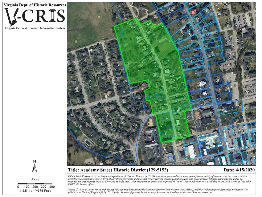
THIS PAGE INTENTIONALLY LEFT BLANK
MANAGEMENT REPORT FOR THE
SALEM HISTORIC DISTRICTS SURVEY

               CITY OF SALEM
                  VIRGINIA

                   By Hill Studio, PC
               120 Campbell Avenue SW
                 Roanoke, VA 24011

 Prepared for the Cost Share Survey & Planning Program
    VIRGINIA DEPARTMENT OF HISTORIC RESOURCES
               2801 KENSINGTON AVENUE
              RICHMOND, VIRGINIA 23221

                   Co-sponsored by:
          CITY OF SALEM PLANNING DIVISION
              21 SOUTH BRUFFEY STREET
                   SALEM, VA 24153

                      MAY 2020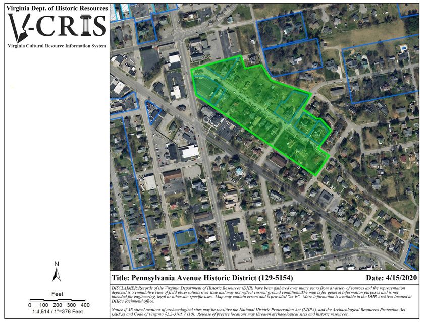
THIS PAGE INTENTIONALLY LEFT BLANK
ACKNOWLEDGEMENTS
Hill Studio would like to thank the following for their support during this project:

Virginia Department of Historic Resources:
Blake McDonald, Architectural Survey & Cost Share Grant Manager
Michael Pulice, Architectural Historian, Western Region Preservation Office

City of Salem
Ben Tripp, City Planner
Mary Ellen Wines, Zoning Administrator
Mary Langhorne Wiley Clarke, Local Historian

Salem Museum:
Fran Ferguson, Executive Director
THIS PAGE INTENTIONALLY LEFT BLANK
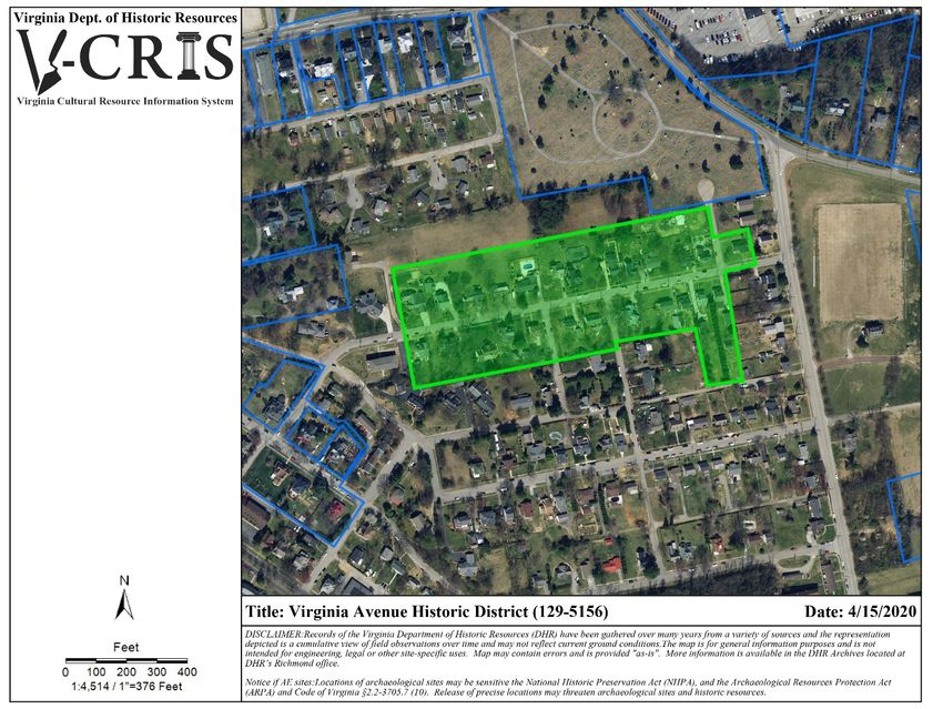
TABLE OF CONTENTS
PROJECT BACKGROUND .................................................................................................................................................. 1
   INTRODUCTION .................................................................................................................................................................. 1
   PROJECT DESCRIPTION ....................................................................................................................................................... 1
   METHODOLOGY .................................................................................................................................................................. 1
   DELIVERABLES..................................................................................................................................................................... 1
HISTORIC CONTEXT ......................................................................................................................................................... 2
ACADEMY STREET HISTORIC DISTRICT............................................................................................................................. 4
   SITE DESCRIPTION ............................................................................................................................................................... 4
   HISTORIC SIGNIFICANCE ..................................................................................................................................................... 4
   ARCHITECTURAL DESCRIPTION ........................................................................................................................................... 4
   ELIGIBILITY RECOMMENDATION ........................................................................................................................................ 5
HIGH STREET HISTORIC DISTRICT .................................................................................................................................... 6
   SITE DESCRIPTION ............................................................................................................................................................... 6
   HISTORIC SIGNIFICANCE ..................................................................................................................................................... 6
   ARCHITECTURAL DESCRIPTION ........................................................................................................................................... 6
   ELIGIBILITY RECOMMENDATION ........................................................................................................................................ 7
LANGHORNE PLACE HISTORIC DISTRICT .......................................................................................................................... 9
   SITE DESCRIPTION ............................................................................................................................................................... 9
   HISTORIC SIGNIFICANCE ..................................................................................................................................................... 9
   ARCHITECTURAL DESCRIPTION ........................................................................................................................................... 9
   ELIGIBILITY RECOMMENDATION ...................................................................................................................................... 10
PENNSYLVANIA AVENUE HISTORIC DISTRICT ................................................................................................................ 11
   SITE DESCRIPTION ............................................................................................................................................................. 11
   HISTORIC SIGNIFICANCE ................................................................................................................................................... 11
   ARCHITECTURAL DESCRIPTION ......................................................................................................................................... 11
   ELIGIBILITY RECOMMENDATION ...................................................................................................................................... 12
SOUTH SALEM HISTORIC DISTRICT ................................................................................................................................ 13
   SITE DESCRIPTION ............................................................................................................................................................. 13
   HISTORIC SIGNIFICANCE ................................................................................................................................................... 13
   ARCHITECTURAL DESCRIPTION ......................................................................................................................................... 13
   ELIGIBILITY RECOMMENDATION ...................................................................................................................................... 14
UNION STREET HISTORIC DISTRICT................................................................................................................................ 16
   SITE DESCRIPTION ............................................................................................................................................................. 16
   HISTORIC SIGNIFICANCE ................................................................................................................................................... 16
   ARCHITECTURAL DESCRIPTION ......................................................................................................................................... 16
   ELIGIBILITY RECOMMENDATION ...................................................................................................................................... 17
VIRGINIA AVENUE HISTORIC DISTRICT .......................................................................................................................... 18
   SITE DESCRIPTION ............................................................................................................................................................. 18
   HISTORIC SIGNIFICANCE ................................................................................................................................................... 18
   ARCHITECTURAL DESCRIPTION ......................................................................................................................................... 18
   ELIGIBILITY RECOMMENDATION ...................................................................................................................................... 19
WATER STREET HISTORIC DISTRICT ............................................................................................................................... 20
SITE DESCRIPTION ................................................................................................................................................................. 20
HISTORIC SIGNIFICANCE ........................................................................................................................................................ 20
ARCHITECTURAL DESCRIPTION ............................................................................................................................................. 20
ELIGIBILITY RECOMMENDATION ........................................................................................................................................... 21
ADDITIONAL RECOMMENDATIONS ............................................................................................................................... 23
BIBLIOGRAPHY .............................................................................................................................................................. 24
THIS PAGE INTENTIONALLY LEFT BLANK
PROJECT BACKGROUND
INTRODUCTION

The City of Salem and Virginia Department of Historic Resources (VDHR) provided funding for the Salem Historic
District Survey project as part of the 2019-2020 VDHR Cost-Share grant program. The purpose of the project was
to identify and document the location and significance of potential historic districts in Salem, all of which are
predominantly residential, to achieve a broad understanding of historic properties in the city and assist in future
preservation-planning efforts. Hill Studio was awarded the project in October 2019.

PROJECT DESCRIPTION

The scope of work included a windshield survey of eight potential historic districts to identify preliminary
boundaries, a preliminary count of properties within each district, and a descriptive summary of their physical
characteristics bolstered by limited research to outline the historical significance of each area. In addition to the
surveys, this management summary provides recommendations on the eligibility of each potential historic
district for listing on the Virginia Landmarks Register and the National Register of Historic Places. This
recommendation includes the identification of applicable National Register Criteria, Area(s) of Significance and
a Period of Significance for each district to be evaluated for register listing. The goal of this identification effort
is to provide broad-based understanding of parts of the City of Salem that have never been surveyed and inform
future preservation planning projects.

METHODOLOGY

All work was planned in accordance with established state and federal standards for documentation of historic
resources. The project was initiated with a kickoff meeting with representatives from Hill Studio, the City of
Salem, and VDHR that included a discussion of available materials in the planning department and a tour of the
proposed districts. Survey tasks included historical research at the Salem Museum, field survey, photography,
and the creation of site plans and base maps. All survey data was entered into Virginia Cultural Resource
Information System (VCRIS). The survey files were completed in accordance with instructions provided by VDHR
in the project scope of work. All survey materials were made in accordance with the Secretary of the Interior’s
Standards and Guidelines for Identification and for Documentation and the VDHR survey manual, “Guidelines for
Conducting Historic Resources Survey in Virginia” (September 2017).

DELIVERABLES

Deliverables included digital and hard copies of the management summary to both VDHR and the City of Salem
as well as completed Virginia Cultural Resource Information System (VCRIS) database entry and survey forms,
one for each identified historic district, with supporting photographic documentation and mapping submitted to
VDHR. In addition, digital copies of these materials was provided to the City of Salem.

                                                          1
HISTORIC CONTEXT
The City of Salem developed on land that was once part of a tract in Botetourt County, conveyed to General
Andrew Lewis from King George III on September 10, 1767. In 1802, James Simpson formally platted the town
of Salem on sixteen acres along the Great Wagon Road. The town included 40 original lots, arranged in a grid
pattern. Early development was oriented along the path of the Great Road, which Simpson named Roanoke
Street (now Main Street). Perpendicular cross streets and alleys separated the blocks. The town grew quickly,
and in 1806, the Virginia General Assembly passed an act formally establishing the Town of Salem.
Throughout the antebellum years, Salem expanded and continued to develop as a commerce and transportation
center. The town was chosen as the terminus for the Roanoke Navigation Company and the Lynchburg and Salem
Turnpike. Both projects were completed in 1836, prompting rapid development. The General Assembly later
authorized additional turnpikes that extended to Salem. The increased traffic resulting from these new transit
patterns led to an expanding population and the construction of various industrial and commercial operations. 1
By 1836, the Virginia legislature formally incorporated the town of Salem and in 1838 Salem became the seat of
the newly formed Roanoke County. A courthouse and several governmental buildings were constructed at the
corner of Main and College Avenue (then Walnut Street) by 1841. Virginia Collegiate Institute—renamed
Roanoke College in 1853—relocated to central Salem from Augusta County in 1847, continuing the
transformation of the town. In 1852, the Virginia and Tennessee Railroad laid down tracks and established a
depot in Salem, increasing the population base and bringing additional economic opportunities. 2 Around this
time, residential streets extending north and south of east-west running Main Street began to develop such as
Academy Street, High Street, and Union Street. In 1868, lots were auctioned off from the recently platted parcels
of the Nathaniel Burwell estate. Many of these lots were purchased by recently freed African Americans.
By 1870, Salem was among the largest communities in Southwest Virginia, with a town population of 1,355. 3 A
period of dramatic growth began in Salem around 1882, when the decision was made to form a connection
between the Norfolk and Western and the Shenandoah Valley railroads near Big Lick, which would later become
the City of Roanoke. The growth of Salem was motivated by the general prosperity brought by the rail lines to
the area. The town’s economic prosperity and escalating population inspired businessmen in the area to form
land companies to develop large parcels of land for commercial, residential and industrial uses. At least twenty-
four land companies were chartered during the late 1880s and early 1890s. Salem’s population grew around the
turn-of-the-century as the most prominent land development companies, including the Salem Improvement
Company, the Salem Development Company, and the South Salem Land Company, promoted the town through
various publications and incentives. In 1889, the Salem Improvement Company formed under the leadership of
Demetrius B. Strouse and J.W.F. Allemong to develop 900 acres of land east of Roanoke Boulevard, including
Pennsylvania Avenue. Virginia Avenue was not part of this plat and developed independently from the mid-1880s
into the mid-1950s. In 1890, the Salem Development Company, chartered by O.L. Stearnes and Alpheus M.
Bowman, platted and sold almost 300 lots in South Salem, which was located south of the Roanoke River and
was not originally within Salem town limits.
The Retail Merchants Association succeeded in bringing a new college to town in 1910, the Roanoke Woman’s
College, a Lutheran-backed school. In 1915, the Elizabeth College and Conservatory of Music at Charlotte, North
Carolina moved to Salem and merged with the Roanoke Woman’s College, becoming the Elizabeth College. A
fire destroyed the main building on campus in 1922 and the school closed.
1
National Register Nomination, “Downtown Salem Historic District.”
2
Ibid
3
“Downtown Salem Historic District”
2Salem’s rising population after World War I led to an increasing need for modern public facilities and the
construction of new buildings during the 1920s. In 1922, Salem hired its first town manager, John Parran Broome,
under whom many civic and street improvements were funded and planned. The appearance of the town
dramatically changed as streets were paved and flanked by curbs, gutters and sidewalks. An extensive system of
street lights was implemented throughout Salem’s residential areas and a water purification plant and
comprehensive sanitary sewerage system were designed. 4 Construction on Main Street extended the
commercial district westward as lots that were formerly developed as residential became commercial. In 1925,
a new neighborhood, Langhorne Place, was platted north of Main Street. This neighborhood featured many
modern conveniences such as street trees, underground electrical work, and a swimming pool.
Although the town was affected by the Great Depression in the 1930s, “a diversified base of governmental,
educational and industrial jobs helped sustain Salem’s economy.” 5 Fortunately for the town, in July 1933, the
Veterans Administration pronounced that it had selected a site in Salem for its new facility. The Neuhoff Meat
Packing Plant (later renamed Valleydale) opened in Salem in 1936 with 75 employees. By 1941, Neuhoff had
expanded to employ over 100 workers. By the end of the decade, a study conducted by the Chamber of
Commerce in 1940 determined that Salem was economically prosperous and stable, with a diversity of business
and industry.
With the end of World War II came a rise in economic prosperity, government activity, and population in Salem.
From 1944-1948, several industries and businesses, including Frigid Freeze Lockers, Jeffreys Laboratories, Ralph
E. Mills Company, Yale and Towne, Woodson Pontiac and two furniture manufacturers, opened in Salem. In
1949-1950, two major industries relocated from Roanoke to Salem: Graham-White Manufacturing Company and
McDowall & Wood Incorporated. 6 The Veterans Administration Hospital constructed new facilities to
accommodate returning soldiers. In 1954, General Electric constructed a multi-million dollar plant that employed
many area residents and contributed to the growth of Salem from the mid-twentieth century through the early
twenty-first century.
The City of Salem currently has three historic districts and a complex listed in the Virginia Landmarks Register
and National Register of Historic Places: the Downtown Salem Historic District (129-0075), the North Broad
Street Historic District (129-5050), the Roanoke Veterans Administration Hospital Historic District (129-0038),
and the Roanoke College Main Campus Complex (129-0005). Salem has also 14 individually listed properties
listed in the Virginia Landmarks Register and National Register.
4
Middleton, 278.
5
“Downtown Salem Historic District”
6
Middleton, 338-339.
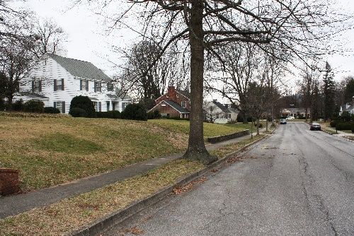
3ACADEMY STREET HISTORIC DISTRICT
SITE DESCRIPTION
Academy Street is located north of Main Street within a larger residential area. The proposed historic district
extends along both sides of the 100-300 blocks of Academy Street, which runs north-south and features public
sidewalks. Academy Street is a wide, residential street that slopes up a large hill to the north. The Academy Street
School anchors the district at the southern end. The 1.4-acre Academy Street Park is located on the east side of
the street within the 300 block. The houses have similar setbacks of approximately 30 feet. Many of the parcels
have detached garages or sheds to the rear of the main houses.
HISTORIC SIGNIFICANCE
The proposed Academy Street Historic District contains a variety of well-preserved middle-class dwellings
constructed in popular architectural styles from the late-nineteenth century into the first quarter of the
twentieth century and therefore appears to be eligible under Criterion C in the area of Architecture. It also
appears to be eligible under Criterion A in the area of Education for its association with the Academy Street
School, Salem’s first public white school. The 1890 Academy Street School (129-0002; NRHP 1981) bounds the
district at the southern end. The street is named for the Academy, highlighting the importance of this resource
to the development of the district. In 1871, the Salem District School Board organized its first public white school
in a pre-Civil War, four-room building that had previously served as a private Presbyterian school for girls known
as Salem Academy. In 1890, the existing school building was erected on the same site as the earlier academy to
accommodate the growing student body. According to the 1981 NRHP nomination, “The construction of the
1890 school on the site of an earlier female academy resulted from an increase in state funding for public
education that coincided with a tremendous construction boom in the Valley caused by the expansion of the
Norfolk and Western Railroad.” The school operated until 1977. The siting of the Academy Street school at the
head of Academy Street indicates the significance of the street within the larger residential area.
ARCHITECTURAL DESCRIPTION
The proposed Academy Street Historic District comprises the 100-300 blocks of Academy Street. As currently
bounded, the district contains approximately 38 primary resources. All resources are residential in character with
the exception of the historic school building. The houses represent popular architectural styles over the 88-year
period of significance, such as Folk Victorian, Queen Anne, Colonial Revival, and Craftsman. Predominant forms
include I-Houses, Four Squares, and Bungalows. Development began at the south end of the street with the
Academy Street School and continued north. Overall, integrity within the district is good with some
contemporary infill, additions, and modifications. The houses north of the 300 block are less historic in character
due to contemporary modifications and additions, a decline in the quality of design, and late dates of
construction, and therefore are not included in the proposed district boundary.
4ELIGIBILITY RECOMMENDATION
The proposed Academy Street Historic District occupies three blocks of a residential street in the larger Salem
residential area north of Main Street. The boundary may need to be modified after further investigation. The
Academy Street Historic District appears eligible as a singular district with its collection of late-nineteenth and
early-twentieth century houses and the presence of the Academy Street School. Further research on the
relationship between the school and the residences built on Academy Street would strengthen the district’s
historic context and inform a National Register of Historic Places nomination. The proposed district appears to
be eligible under Criterion A in the area of Education and Criterion C in the area of Architecture. The
recommended period of significance extends from ca. 1880, when residential construction began on Academy
Street, to ca. 1930, approximately when the last house retaining sufficient historic integrity was constructed.
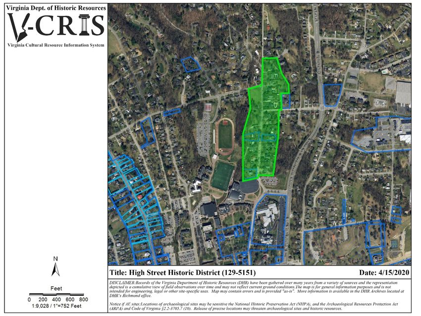
5HIGH STREET HISTORIC DISTRICT
SITE DESCRIPTION
High Street is located north of the Roanoke College campus and west of Thompson Memorial Drive (Route 311).
The proposed historic district extends along both sides of the 300-600 blocks of High Street. High Street is a wide,
relatively flat, residential street that runs north-south. Public sidewalks extend along both sides of the street
within the 300-400 blocks. Stone retaining walls front the parcels on the west side of the street within the 400
block. Iron fences enclose several of the front yards at the south end of the district. The houses at the north end
of the district in the 500-600 blocks are set back farther from the public sidewalk than the houses at the south
end of the street. Many of the parcels have detached garages or sheds to the rear of the main houses.
HISTORIC SIGNIFICANCE
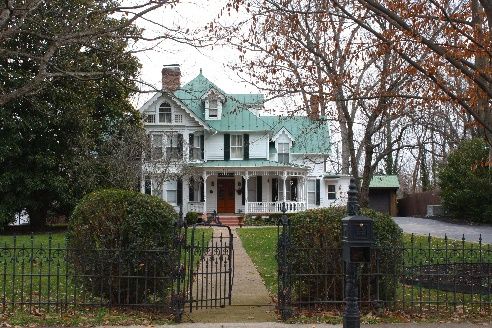
The proposed High Street Historic District contains a variety of both high-style and vernacular historic dwellings
constructed in popular architectural styles from the mid-nineteenth to mid-twentieth century. According to
Sanborn Fire Insurance maps and the 1883 O.W. Gray & Son map, High Street developed as one of the earliest
residential streets in Salem. The boundaries may need to be modified upon further survey and research, but the
district as currently proposed appears to be eligible under Criterion C in the area of Architecture. At the south
end of the street, 335 High Street (129-0058), is one of the earliest houses in the district. Constructed ca. 1855,
this brick house displays the influence of several popular styles of the time: Greek Revival, Italianate, and
Carpenter Gothic, with its low-pitch hipped roof, shouldered architrave window trim, Greek columns, decorative
roof brackets, and jig-sawn ornament. Built by Zebulon Boon, the house remained in the prominent Stearnes
family for about a century. The house at 342 High Street, built ca. 1854 by S. Carson Wells, is another early house
in the district. This house demonstrates the Greek Revival style with its entrance portico, symmetrical façade,
low-pitch hipped roof, and boxed cornice. Wells originally moved to Salem in 1847 as one of six students who
came from the Virginia Collegiate Institute in Augusta County when it moved to Salem to become Roanoke
College. Wells went on to become a prominent member of the Roanoke College faculty and built his house in
close proximity to the college. According to the 1883 Gray map, the Roanoke College president, Julius D. Dreher
lived on High Street, where Roanoke College’s Olin Theater currently stands. Per the 1900 U.S. Census, several
college professors, a land company president, and a physician lived on High Street. Roanoke College maintains a
presence on the residential portion of the street, north of the campus, with its garden located on the west side
of High Street within the 500 block. The district also appears to be eligible under Criterion A for Community
Planning and Development as it represents residential development driven by private investment of local leaders
from the mid-nineteenth century into the present.
6ARCHITECTURAL DESCRIPTION
The proposed High Street Historic District comprises the 300-600 blocks of High Street. As currently bounded,
the district contains approximately 24 primary resources. All resources are residential in character. The district
comprises a significant concentration of high-style and vernacular houses that remain in excellent condition. The
houses represent popular architectural styles from the nineteenth and twentieth centuries, such as Greek
Revival, Italianate, Queen Anne, Colonial Revival, and Tudor Revival. Predominant forms include Four Squares
and I-houses; many of the Queen Anne and Tudor Revival houses are complex in form. Development first
occurred at the southern end of the street near Main Street and continued north over the first half of the
twentieth century. Overall, integrity within the district is excellent with some contemporary infill, additions and
modifications. The houses north of the 600-block post-date the recommended period of significance.
ELIGIBILITY RECOMMENDATION
The proposed High Street Historic District occupies four blocks of one of the earliest residential streets in Salem.
The boundary may need to be modified after further investigation. The High Street Historic District appears
eligible as a singular district with its sophisticated houses and its proximity to Roanoke College. Further research
on the relationship between Roanoke College and the residences built on High Street would strengthen the
district’s historic context and inform a National Register of Historic Places nomination. The general development
pattern, with its lower density and larger setbacks, is different from the other north-south residential streets
surrounding Main Street. The proposed district appears to be eligible under Criterion A in the area of Community
Planning and Development and Criterion C in the area of Architecture. The recommended period of significance
extends from ca. 1855, approximately the earliest date of construction, to ca. 1957, when the last house retaining
sufficient historic integrity was constructed.
78
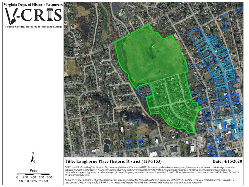
LANGHORNE PLACE HISTORIC DISTRICT

SITE DESCRIPTION

The boundaries of the proposed Langhorne Place Historic District correspond with the 1925 Langhorne Place
plat map. Streets within the district include James Street, Taylor Avenue, Lewis Avenue and Locust Avenue. The
Salem Municipal Golf Course, located within the district, anchors the district at the north end. A community
swimming pool, built for residents of Langhorne Place by the Wiley family, is located behind Lewis Avenue along
Dry Branch Alley. The Glenmary Apartments, located within the district, anchor the district at the south end.
Public sidewalks are extant throughout the relatively flat district. The houses are generally setback about 30 feet
from the public sidewalks. Many of the parcels have detached garages or sheds to the side and rear of the main
houses.

HISTORIC SIGNIFICANCE

The proposed Langhorne Place Historic District encompasses the parcels associated with the Langhorne Place
housing development, which was platted in 1925. The district appears to be eligible under Criteria A and C in the
areas of Community Planning and Development and Architecture. Langhorne Place was platted and developed
by Frank C. and Annie Langhorne Wiley on the Langhorne family’s land north of Main Street. The Wileys and the
Langhornes were two of Salem’s prominent families. Members of the Wiley family were renowned doctors,
businessmen, and civic leaders in the community. James Langhorne, a bank officer, served on Salem’s town
council in the early-twentieth century and owned prosperous roller mills. The Wileys named the streets after
various Langhorne and Wiley family members, planted trees throughout the neighborhood and laid all the
underground electrical work. They built the neighborhood swimming pool when the first houses were under
construction. The Wileys also constructed the Glenmary Apartments in the early 1930s as part of the
neighborhood. Around 1925, the Wileys built the first house in the neighborhood at 106 Lewis Avenue on
speculation. Judge Thurston Keister originally purchased this Colonial Revival house. William Wolfenden built the
second house in the neighborhood at 112 Lewis Avenue. Wolfenden was a pioneer electrical engineer and
contractor in the Roanoke Valley. Other early homeowners in the neighborhood included Roanoke College
professors, a Roanoke College dean, and a clerk of the circuit court. In 1929 the golf course opened to residents
of Langhorne Place. Development boomed after World War II as men returning from war erected houses on
undeveloped lots generally on the north side of James Street.

ARCHITECTURAL DESCRIPTION

The proposed Langhorne Place Historic District corresponds to the original boundaries of the January 1925
Langhorne Place plat map. As currently bounded, the district contains approximately 70 primary resources. All
resources are residential in character. The houses represent popular architectural styles over the 35-year period

                                                        9
of significance, such as Colonial Revival, Tudor Revival, and Minimal Traditional. Overall, integrity within the
district is good with some contemporary infill, additions, and modifications.
ELIGIBILITY RECOMMENDATION
The proposed Langhorne Place Historic District encompasses the neighborhood laid out in 1925. This district has
merit under both Criterion A: Community Planning & Development as it represents the development of a
planned neighborhood by members of two of Salem’s prominent families in the second quarter of the twentieth
century and Criterion C for its collection of intact historic houses. Langhorne Place is a definable geographic area
that can be distinguished from surrounding properties by changes such as density, scale, type, age, style of
buildings, and differences in development pattens. The recommended period of significance extends from 1925,
when the Town Council approved the development of the Langhorne Place subdivision to ca. 1960 when
subdivision lots were substantially built out.
10PENNSYLVANIA AVENUE HISTORIC DISTRICT
SITE DESCRIPTION
Pennsylvania Avenue is located east of South College Avenue (Route 11) within a larger residential area. The
proposed historic district extends along both sides of the 300-400 blocks of Pennsylvania Avenue, terminating at
Walnut Avenue. Pennsylvania Avenue is a flat, wide, residential street. Public sidewalks extend along both sides
of the street. Handsome iron fences enclose many of the front yards throughout the district. The houses retain
a similar setback of approximately 30 feet from the public sidewalk. Many of the parcels have detached garages
or sheds to the side and rear of the main houses.
HISTORIC SIGNIFICANCE
The proposed Pennsylvania Avenue Historic District comprises a distinguished concentration of well-preserved
historic houses constructed around the turn of the twentieth century. The district appears to be eligible under
Criterion A and Criterion C in the areas of Community Planning and Development and Architecture. Extending
from College Avenue, one of the busiest thoroughfares in Salem, Pennsylvania Avenue was a popular place for
the town’s leaders and prominent businessmen to build homes for their families. One of the most notable early
residents on Pennsylvania Avenue was J.W.F. Allemong, president of the Salem Improvement Company.
Allemong built two grand Queen Anne houses on the north side of Pennsylvania Avenue for himself (405
Pennsylvania Avenue) and for his son (415 Pennsylvania Avenue). Dr. Julius C. Darden, physician-chairman of the
board of health in Salem, built his home at 360 Pennsylvania Avenue in 1907.
ARCHITECTURAL DESCRIPTION
The proposed Pennsylvania Avenue Historic District comprises the 300-400 blocks of Pennsylvania Avenue. As
currently bounded, the district contains approximately 21 primary resources. All resources are residential in
character. Although construction began ca. 1880 in the district, the sizable houses represent popular
architectural styles around the turn of the twentieth century, such as Folk Victorian, Queen Anne, and Colonial
Revival. Overall, integrity within the district is excellent as all houses date from the late-nineteenth to the early-
twentieth century and retain much of their original forms and materials. The district terminates at Walnut
Avenue as the topography, density of development, quality of architectural design and prevalence of
contemporary infill and modifications significantly changes.
11ELIGIBILITY RECOMMENDATION
The proposed Pennsylvania Avenue Historic District occupies two blocks of an early residential street in Salem.
This district is recommended eligible as a standalone district due to the quality of architectural design and
materials as well as the significance of the early residents on Pennsylvania Avenue to the City of Salem. It appears
to have strong eligibility potential under Criterion A in the area of Community Planning and Development and
Criterion C in the area of Architecture. The recommended period of significance extends from ca. 1880,
approximately the earliest date of construction, to ca. 1924, approximately the last date of construction.
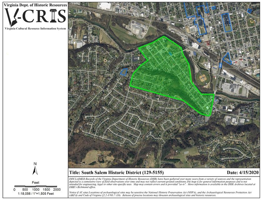
12SOUTH SALEM HISTORIC DISTRICT
SITE DESCRIPTION
The boundaries of the South Salem Historic District generally correspond with the Salem Development
Company’s 1890 plat map. Additionally, a windshield survey of extant resources and historic Sanborn Fire
Insurance maps were used to refine the boundaries. Generally, the district is bounded by the Roanoke River to
the north, Colorado Street to the east, Kimball Avenue to the south and Roanoke River/Mulberry Street to the
west. The main streets with the district are Eddy Avenue, Front Avenue, Bowman Avenue, Central Avenue,
Oakview Drive, Palmer Avenue, Kimball Avenue, and Mulberry Street. The topography is relatively flat
throughout the north half of the district. Built into a steep hillside, Prospect Park and the streets south of the
park are contoured to the sloping topography. Public sidewalks are extant in the north end of the district. The
houses are set close to the public sidewalk. Many of the parcels have detached sheds to the side and rear of the
main houses.
HISTORIC SIGNIFICANCE
The proposed South Salem Historic District generally corresponds to the parcels platted by the Salem
Development Company in 1890 and the development of those parcels as confirmed by a series of historic
Sanborn Fire Insurance maps. The district appears to be eligible under Criterion A and Criterion C in the areas of
Community Planning and Development and Architecture. O. L. Stearnes developed South Salem after purchasing
the 856-acre Shanks Farm to the south of the Roanoke River in Roanoke County. He chartered the Salem
Development Company with Alpheus M. Bowman in January 1890. The company sold almost 300 lots during that
year. The Salem Development Company also provided a water works and several sites for industries including
the Holstein Woolen Mills, the Chadwick Two-Wheeler Works, the Salem Brick Works, and the Salem Gas Heater
Company. Parcels were popular due to their proximity to the various industries as well as the proposed junction
of the Roanoke & Southern Railroad and the Norfolk & Western Railroad, which was ultimately built in Roanoke
rather than Salem. The housing within South Salem is predominantly working-class, as most of the residents of
the neighborhood worked in the nearby industrial outfits. In January 1905, Salem purchased South Salem’s water
system from the Salem Development Company, who had gone into receivership. In 1911, a school was
constructed on Central Avenue for the children in South Salem. In 1914, a group of doctors established Mt. Regis
Sanatorium within the district towards the southern boundary. It remained open until 2016 when it was
destroyed by a fire and was rebuilt elsewhere in Salem. Throughout the first half of the twentieth century South
Salem remained outside of Salem’s city limits, not receiving any services except water from the city. Although
residents of South Salem considered incorporation in the early 1950s, the City of Salem annexed all of South
Salem in 1953. South Salem remains a large working-class neighborhood, although many of the historic industries
once present are now gone.
13ARCHITECTURAL DESCRIPTION
The proposed South Salem Historic District corresponds to the land platted by the Salem Development Company
at the end of the nineteenth century. As currently bounded, the district contains approximately 400 primary
resources. Most of the resources are residential in character with a few commercial buildings and churches
throughout the district. The vernacular houses draw influence from the Folk Victorian, Colonial Revival, and
Craftsman styles. Typical of working-class neighborhoods, rows of identical houses constructed by the same
builder on speculation are found throughout the district. The majority of the houses are 1 to 1.5 stories in height
and of frame construction clad with various siding materials. Prominent forms include the gable-front-and-wing,
the gable-front, bungalow, ranch, and one-story pyramidal cottages, although examples of the I-house and
American Four-Square are scattered throughout the district. Overall, integrity within the district is fair with some
contemporary infill, additions, and modifications. Additionally, many of the houses exhibit signs of disrepair and
deterioration. Within the district, post-1970 construction is concentrated along Kimball Avenue and Palmer
Avenue.
ELIGIBILITY RECOMMENDATION
The proposed South Salem Historic District captures the working-class neighborhood developed by the Salem
Development Company in 1890 on land south of the Roanoke River. This district appears to possess strong
eligibility under Criterion A: Community Planning & Development for its historical planned development as a
working-class neighborhood and under Criterion C: Architecture as collectively the vernacular buildings visually
communicate the historical significance of the district as a working-class neighborhood with strong ties to nearby
industries. The recommended period of significance extends from 1890 when the Salem Development Company
platted the Shanks Farm land, to 1970, the fifty-year cut-off.
1415
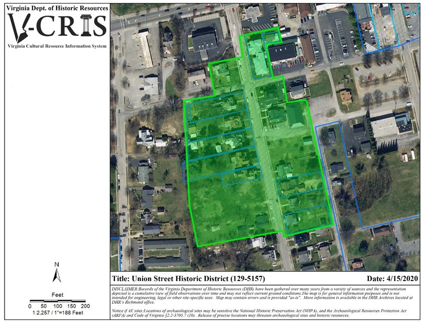
UNION STREET HISTORIC DISTRICT

SITE DESCRIPTION

Union Street is located south of Main Street within a larger residential area. The proposed historic district
generally extends along both sides of the first three blocks of Union Street, which runs north-south and features
public sidewalks. Union Street is a wide, relatively flat, residential street. The houses retain an average setback
of about 25 feet. Many of the parcels have detached garages or sheds to the rear of the main houses.

HISTORIC SIGNIFICANCE

The proposed Union Street Historic District contains a collection of high-style Victorian era dwellings constructed
from the mid-nineteenth century to the early-twentieth century. The district appears to be eligible under
Criterion A and Criterion C in the areas of Community Planning and Development and Architecture. During the
second half of the nineteenth century, local civic and economic leaders took up residence on Union Street.
Newcastle (12 Union Street), one of the earliest houses on Union Street, was constructed in the mid-nineteenth
century, likely by local Deyerle-family builders. In 1878, Judge Wingfield and Claudia Griffin bought the house.
Judge Griffin served as Judge of the County Court from 1874-1891. In 1944, North Cross School, a private school
presently located in Roanoke County, was founded in this house by Mrs. Howard Butts and Mrs. Billy Northcross
Ellis. Another early house, 224 Union Street, was constructed ca. 1880 by James C. Deyerle, a prominent builder
and brick maker in the region. According to Sanborn maps, Deyerle’s brickyard was located roughly across the
street on the west side of Union. The ca. 1890 house at 103 Union Street was occupied by M.G. McClung, a
lawyer and the editor of the Salem Sentinel, in the early-twentieth century.

ARCHITECTURAL DESCRIPTION

The proposed Union Street Historic District encompasses approximately the first three blocks of Union Street
from 12 Union Street to 225 Union Street. As currently bounded, the district contains approximately 14 primary
resources. All resources are residential in character. The houses represent popular architectural styles over the
60-year period of significance (ca. 1850-ca. 1910), such as Greek Revival, Folk Victorian, and Queen Anne. The
house at 12 Union Street exemplifies the Greek Revival style with its symmetrical facade, low-pitched hipped
roof, and rectangular transom and sidelights surrounding the front entrance. The house at 115 Union Street is
an excellent example of a high-style Queen Anne with its irregular massing, fishtail-shingled slate roof, finials,
roof brackets and cresting, and a wraparound porch supported by turned posts and a spindled frieze. Overall,
integrity within the district is good with some additions and modifications. The houses south of 225 Union Street
are less historic in character due to the lower quality of architectural design, contemporary modifications and
additions, and later dates of construction.

                                                        16
ELIGIBILITY RECOMMENDATION
The proposed Union Street Historic District occupies approximately three blocks of a residential street within the
larger residential area south of Main Street in Salem. The boundary may need to be modified after further
investigation. This district is recommended eligible as a standalone district due to the quality of architectural
design and materials as well as the significance of the early residents on Union Street to the City of Salem.
Presently, it appears to be potentially eligible under Criterion A for Community Planning and Development and
Criterion C for Architecture. The recommended period of significance extends from ca. 1850, the earliest date
of construction, to ca. 1910 to capture the construction of the most architecturally distinguished and historically
significant houses along Union Street.
17VIRGINIA AVENUE HISTORIC DISTRICT
SITE DESCRIPTION
Virginia Avenue is located west of Idaho Street and the Roanoke College Elizabeth Campus. The street is part of
a larger residential area south of E. Main Street. The proposed historic district extends along both sides of the
700-800 blocks of Virginia Avenue, a wide, sloping, residential street that runs east-west. Public sidewalks extend
along both sides of the street. Masonry retaining walls front the parcels on the north side of the street. Wood
fences enclose several of the front yards at the east end of the district. The houses are generally set back 30 feet
from the public sidewalks. Many of the parcels have detached garages or sheds to the rear of the main houses.
HISTORIC SIGNIFICANCE
The proposed Virginia Avenue Historic District contains a variety of middle-class dwellings constructed in popular
architectural styles from the late-nineteenth to mid-twentieth century. The district appears to be eligible under
Criterion A and Criterion C in the areas of Community Planning and Development and Architecture. While the
development pattern and architectural styles of the houses on Virginia Avenue are similar to those of the
surrounding neighborhood, the proposed district represents an intact example of this broad period of residential
development in Salem with a relatively high level of integrity and stylistic diversity. Beginning around 1880,
Virginia Avenue developed gradually over the course of approximately 70 years. Virginia Avenue was not part of
a land company plat, which resulted in slower growth that reflects a broader period of time. Development largely
occurred in the early twentieth century, prior to World War I, and in the late 1940s through 1960s, immediately
before and after World War II as it parallels the growth of Salem. According to U.S. Census data, many of the
residents of Virginia Avenue held middle-class jobs such as clerks, teachers, tradesmen, mechanics, and
salesmen.
ARCHITECTURAL DESCRIPTION
The proposed Virginia Avenue Historic District comprises both sides of the 700-800 blocks of Virginia Avenue. As
currently bounded, the district contains approximately 23 primary resources. All resources are residential in
character. The houses represent popular architectural styles over the 72-year period of significance (ca. 1885 –
ca. 1957), such as Colonial Revival, Folk Victorian, and Queen Anne. Predominant forms include Bungalows,
Ranches, and Cape Cods. Overall, integrity within the district is good with some contemporary infill, additions,
and modifications. The houses south of the 700 block are less historic in character due to their contemporary
modifications and additions and late dates of construction and are therefore not included in the proposed
historic district boundary. The house at 728 Virginia Avenue is an excellent example of a high-style Queen Anne
with its irregular massing, scroll-sawn ornament, spindled porch supports, polygonal bay windows, and
ornamented central tower. The bungalow at 826 Virginia Avenue exemplifies the Craftsman style with its 4/1
wood-sash windows with vertical muntins, squared porch supports on brick piers, and extended eave overhangs.
18ELIGIBILITY RECOMMENDATION
The proposed Virginia Avenue Historic District occupies two blocks of a residential street in the larger Salem
residential area east of College Avenue. The boundary may need to be modified after further investigation.
Presently, it appears to be potentially eligible under Criterion A for Community Planning and Development and
Criterion C for Architecture. This area differs from the surrounding area as it was not developed specifically by a
land company or as a platted subdivision and features a broader range of architectural styles and forms. The
recommended period of significance extends from ca. 1885, the earliest date of construction, to ca. 1957, when
most of the district had been developed.
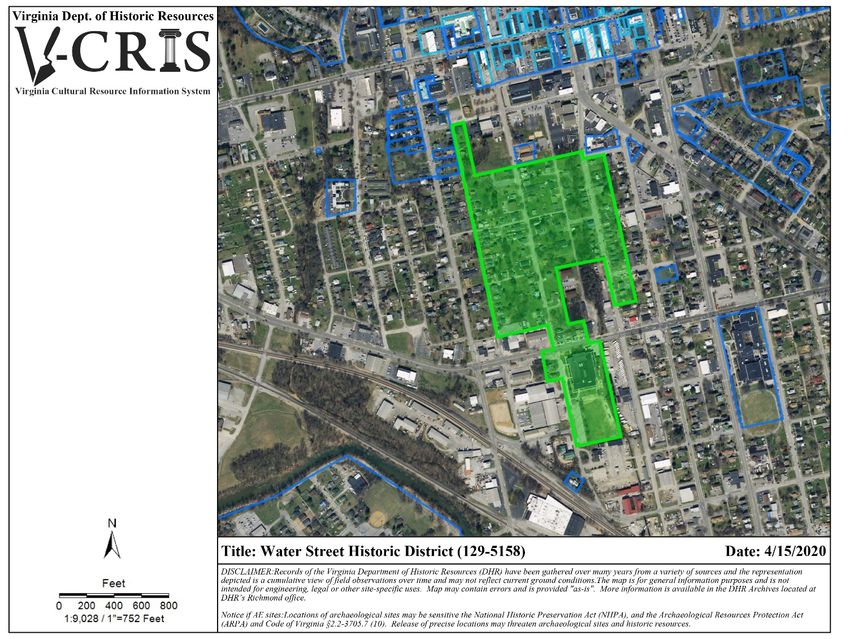
19WATER STREET HISTORIC DISTRICT
SITE DESCRIPTION
The Water Street district encompasses approximately three blocks along South Broad Street (formerly Water
Street), four blocks along Chapman Street, two blocks along White Oak Street and three blocks along South
Market (formerly Alabama Street) Street. The district is generally bounded by Burwell Street to the north, South
Market Street to the east, 4th Street to the south and Chapman Street to the west. The topography is relatively
flat throughout the district. Public sidewalks are extant in the north end of the district. The parcels are fairly
small, and the houses are set close to the public sidewalk. Some of the parcels have detached sheds to the side
and rear of the main houses.
HISTORIC SIGNIFICANCE
The proposed Water Street Historic District generally corresponds to the earliest African American neighborhood
south of Main Street. The district appears to be eligible under Criterion A in the area of Ethnic Heritage: Black.
The first African Americans to settle in the neighborhood purchased lots at a public auction arranged by Charles
Burwell who laid out the streets and parcels from the estate of his father, Nathaniel Burwell, after his death.
Many recently freed African Americans purchased these small, comparatively affordable lots near the railroad
at the June 1868 auction. These early lots were located along Water (now South Broad) Street and Chapman
Street. The members of the African American community not only built their houses on these lots, but churches,
businesses and a public school as well. The first public school, School No. 2/ Salem Colored, was located on the
northwest corner of Chapman Street and served the community from 1872 to 1890. In 1890, a new school,
named the Roanoke County Training School, was constructed on the corner of Water Street and School Alley. It
offered vocational as well as academic classes for African American students. Black-owned businesses on Water
Street included restaurants, ice cream parlors, barber shops, drugstores, dry cleaners, and various other
businesses. In November 1913, an ordinance was adopted by the town that created Segregation District No. 1,
the African American district. This district was bounded by Calhoun Street, White Oak Alley, 5th Street, and
Chapman Street. In 1914 district was modified to extend to Alabama (currently South Market) Street rather than
White Oak Alley to the East. Based on the 1962 Poll Tax Register for Roanoke County and the 1961 City Directory,
many African Americans continued to live on Alabama, Water and Chapman Streets. In 1940, the George
Washington Carver school opened at the SE corner of 4th Street and S. Broad Street. Theron N. Williams, principal
of the Roanoke County Training School, and Roland C. Cook, the County School Superintendent, advocated for
this new school due to the inadequate facilities at the Roanoke County Training School. The location of the Carver
school was controversial as the initial site choice was along Main Street to the west of town. However, many
white residents pushed back against this site. The current location along Fourth Street was chosen as it was
adjacent to the Water Street community even though it was a smaller site and had a stream running through it.
Most of the remaining historic resources are small- to mid-size vernacular houses. Most of the historic churches,
20schools, and commercial buildings have since been demolished, although the George Washington Carver School
still stands and continues to function as a school.
ARCHITECTURAL DESCRIPTION
The proposed Water Street Historic District corresponds to the historic African American neighborhood
developed after the Civil War. As currently bounded, the district contains approximately 100 primary resources.
Most of the resources are residential in character with a few commercial buildings and churches throughout the
district. The vernacular houses feature motifs of popular architectural styles from the 106-year period of
significance. Overall, integrity within the district is poor with a significant amount of contemporary infill,
additions, and modifications. Additionally, many of the houses exhibit signs of disrepair and deterioration.
ELIGIBILITY RECOMMENDATION
The proposed Water Street Historic District captures the African American neighborhood that developed after
the Civil War and remained predominantly African American over the next century. The individual resources in
the proposed district lack architectural and historical significance; however, the district as a whole has strong
eligibility potential under Criterion A in the area of Ethnic Heritage: Black. Due to the demolition and alterations
of properties along these streets, the grouping as a whole does not have strong eligibility potential under
Criterion C: Architecture. The recommended period of significance extends from 1868 when the first lots were
purchased, to 1970, the fifty-year cut-off. Additionally, other names for this historic district should be explored
as Water Street no longer exists and the district encompasses multiple streets. Naming it the Water Street
Community Historic District would incorporate the historic importance of this area as a neighborhood rather
than a single street which has since been renamed.
2122
ADDITIONAL RECOMMENDATIONS
In addition to the eight potential historic districts identified during the project, the following districts and
individual properties warrant further investigation and potentially evaluation for listing in the Virginia Landmarks
Register and the National Register:
Potential Historic Districts:
    1.   Lake Spring Park/ W. Main St. Residential
    2.   Elizabeth Campus (129-5028), surveyed 2012, recommended potentially eligible
    3.   E. Main St./Longwood Park HD (129-5046), determined potentially eligible in 2011
    4.   Wiley Court (129-5049), determined eligible 2015
    5.   Downtown Salem Historic District (expansion)

Potential Individually Eligible Properties (outside of potential historic districts)
    1.   Salem N&W RR Passenger Station (129-5024), surveyed 2008
    2.   East Hill Cemetery (129-0077), surveyed 2011
    3.   Railroad House, 729 S. Broad St. (129-5053), surveyed 2013
    4.   Thaden-Jordan Furniture Plant (129-5052), surveyed 2013
    5.   Virginia Baptist Children’s Home (129-5013), determined eligible in 2000; potentially eligible in 2014

Hill Studio recommends that the City of Salem consider the above potential historic districts and properties in
future preservation planning efforts. The City should seek funding to pursue register nominations for those
resources previously determined eligible for register listing. For properties not previously evaluated, more
thorough survey documentation, investigation and assessment should be conducted to determine the historic
and architectural significance and integrity of these properties.

                                                          23
BIBLIOGRAPHY
1962 Capitation (Poll) Tax Register for Roanoke County. On File at the Salem Museum.
Clarke, Mary Langhorne Wiley. Interview with Mary Langhorne Wiley Clarke. Interview by Kate Kronau, February
24, 2020.
“Langhorne Place is 70.” Historic Salem. Summer 1997.
“Langhorne Place to be Featured in Homes Tour.” Historic Salem, Winter 1997-1998.
Middleton, Norwood C. Salem: A Virginia Chronicle. Salem, VA: Salem Historical Society Inc., 1986.
National Register Nomination, “Academy Street School,” Virginia Department of Historic Resources Archives File
129-0002, Richmond.
National Register Nomination, “Downtown Salem Historic District,” Virginia Department of Historic Resources
Archives File 129-0075, Richmond.
National Register Nomination, “North Broad Street Historic District,” Virginia Department of Historic Resources
Archives File 129-5050, Richmond.
“Pennsylvania Avenue is Homes Tour Site.” Historic Salem, Winter 1996-1997.
“Public Auction Started Water Street.” Historic Salem, Spring 2001.
Roanoke, Salem, and Vinton (Roanoke County, Va.) City Directory. Richmond, Va.: Hill Directory Co.
“Salem Has Its Own Historic Registry.” On file at the Salem Museum.
“The Salem Museum’s 1996 Holiday Homes Tour.” Brochure. On File at the Salem Museum.
24You can also read