Send Neighbourhood Development Plan 2019 2034 - Referendum Version October 2020
←
→
Page content transcription
If your browser does not render page correctly, please read the page content below
Send Neighbourhood Development Plan – Referendum Version

Send Neighbourhood Development Plan
            2019 – 2034

           Referendum Version
                       October 2020

                                                                 Page | 0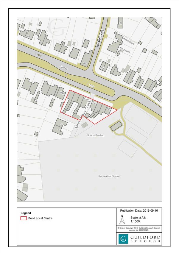
Send Neighbourhood Development Plan – Referendum Version

                                     Foreword

Fellow Residents,

Welcome to the Send Neighbourhood Development Plan (SNDP) covering the three
settlement areas of Send, Send Marsh and Burnt Common,

Since being designated a Neighbourhood Area in mid-2015, residents, business
owners, local workers, parish councillors and professional advisers have contributed
to the making of this plan. On behalf of Send Parish Council I want to extend my
thanks for all the support they have provided.

Our Neighbourhood Development Plan must align with national legislation and with
the Adopted Guildford Borough Local Plan in order to be accepted by the external
examiner and incorporated into the statutory development plan. The Local Plan
includes allocations for Send which are significant in scale when measured against
the existing dwellings, employment and infrastructure. These allocations are planned
to meet the development needs of the borough up to 2034, and as such, the SNDP
does not allocate further development but seeks, via its policies, to influence the
type, style, tenure and design of the allocated developments, and to secure the
best outcomes for our parish.

 The plan includes non-statutory community aspirations which are not finite, but will
inform an action plan that together with the policies will guide residents and other
stakeholders on how the community seeks to plan for and deliver its objectives.

Having an adopted neighbourhood development plan will ensure that, in addition
to Section 106 contributions, at least a quarter of the Community Infrastructure Levy
(CIL) collected for chargeable development in Send will be re-invested in the parish.
The Guildford CIL is expected to be put to consultation in late 2021.

I believe the Send Neighbourhood Development Plan is a positive contribution to
sustainable development in our parish and the borough.

Guida Esteves

Chairman Send Parish Council Neighbourhood Development Plan Working Group
                 _______________________________________________________
                    Send Parish Council, 28 Send Road Send Woking GU23 7ET

                         01483 479312 clerk@sendparishcouncil.gov.uk

                                                                                Page | 0
Send Neighbourhood Development Plan – Referendum Version

Contents                                                                      Page
      Non-Technical Summary                                                          2-8

1.0   How to Read and Use the Send Neighbourhood Development Plan                   9-10

2.0   Neighbourhood Planning: Legislative and Planning Policy Context                11

             - National Planning Policy Framework                                    11

             - Local Planning Context                                                11

             - The Link Between Development and Infrastructure                       12

             - Strategic Environmental Assessment and Habitats Regulations Assessment 12

             - The Plan Preparation Process                                          13

             - The Examination Process                                               13

             - The Approval Process                                                  14

3.0   Community Consultation                                                      15-17

4.0   The Parish of Send                                                          18-19

5.0   Vision & Objectives                                                           20

6.0   Planning Policies                                                          21-45

7.0   Non-Statutory Community Aspirations                                        46-48

8.0   Delivery Plan                                                                 49

             - Introduction                                                         49

             -Development Management                                                49

             - Infrastructure Projects                                              49

             - Monitoring and Review of the Neighbourhood Development Plan          49

Appendices

      A)     Policies Maps                                                       50-54

      B)     List of Infrastructure Projects                                        55

      C)     Map of the Wey and Godalming Navigations Conservation Area and
             Corridor of the River Wey (extent within Send Parish)       56

                                                                                  Page | 1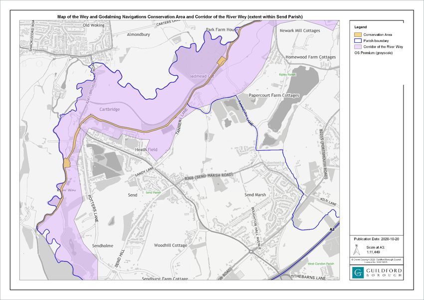
Send Neighbourhood Development Plan – Referendum Version

 Non-Technical Summary

In May 2015, Send Parish Council              which was adopted in April 2019. The
considered whether to prepare a               Local Plan includes housing and
Neighbourhood Development Plan                employment allocations for Send. The
and announced its intentions on its           Send Neighbourhood Development
stand at the Annual May Fair. On 2nd          Plan cannot override these
July 2015, Guildford Borough Council          allocations. Because these allocations
designated a Neighbourhood Area for           are of a significant scale and planned
the whole of the Parish of Send to            to meet the development needs for
enable Send Parish Council to prepare         the Borough up to 2034, the Send
the Send Neighbourhood                        Neighbourhood Development Plan
Development Plan. Working Groups              does not allocate further development
were formed to look at the issues and         but rather seeks to influence the type,
a series of community engagement              style, tenure and design of these
events carried out from 2016, including       allocated developments and any
a public survey in 2018.                      other future windfall developments.

The Send Neighbourhood                        The Send Neighbourhood
Development Plan is required to be in         Development Plan includes the
general conformity with the strategic         following Planning Policies and
policies of the Guildford Local Plan,         Community Aspirations:

 Planning Policies

 Policy Send 1 - Design

High quality and sustainable design is expected in Send and shall conserve and
enhance its heritage and environmental assets including the Wey & Godalming
Navigations Conservation Area and its setting. All development proposals will be
expected to demonstrate how they promote and reinforce the local distinctiveness
and high quality built and natural environment of Send with reference to the Send
Neighbourhood Development Plan Character Assessment. Proposals should seek to
ensure that development does not result in significant adverse effects on the key
views identified in the maps on pages 25 to 32 and respects and retains key natural
landscape assets. In particular, in the following Character Areas:

A)    Wey Navigation and River Wey – proposals must conserve and enhance the
      Wey & Godalming Navigations Conservation Area;

B)    A247 and Sanger Drive – proposals must retain its open green feel with wide
      verges and trees, stretches of hedging and swathes of wild-flowers and
      daffodils;

                                                                                Page | 2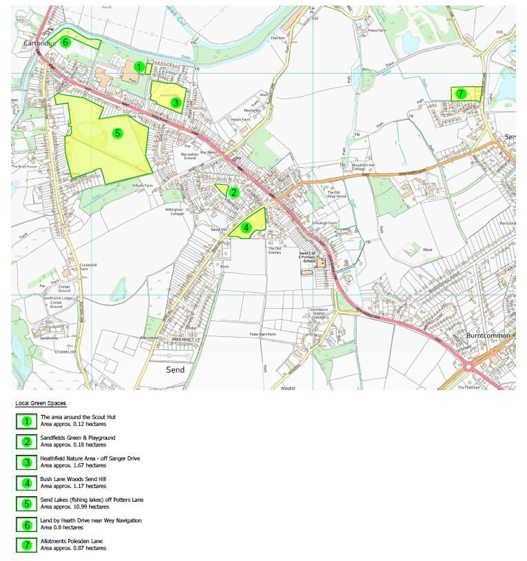
Send Neighbourhood Development Plan – Referendum Version

C)   Church Lane, Vicarage Lane and Woodhill – proposals must retain and
     respect the very attractive buildings, the beautiful and ancient church and
     graveyard, and the stud farm;

D)   Potters Lane and Fishing Lakes – proposals must reflect its rural and unspoilt
     character with many trees and beautiful lakes and very little light pollution;

E)   Send Hill – proposals must reflect its very green and rural character as a result
     of many mature trees and hedges;

F)   Tannery Lane – proposals must retain its narrow country lane character and
     rights of way through farmland linking to Send Marsh Road and beyond;

G)   Polesden Lane, Send Marsh Green and Send Marsh Road (west) – proposals
     must demonstrate how they have been designed to conserve, or where
     possible enhance, the significance of the oldest surviving buildings in Send,
     many of which are listed, and the oldest part of the village at Send Marsh
     Green;

H)   Send Marsh Road (south) and Send Marsh Estate – proposals must reflect the
     variety of two storey dwelling types in this area;

I)   The area from the stream by the Villages Medical Centre along Send Barns
     Lane including the roads to the left and Boughton Hall Avenue - Proposals
     must include retaining the open and green appearance of the roads leading
     off Send Barns Lane where the majority of the front gardens are open plan
     with the rest having low hedges in a setting of mature trees. Proposals must
     include the retention of grass verges along Send Barns Lane and along the
     roads leading off it except where highways improvement schemes may be
     required. Boughton Hall Avenue proposals must retain the generous number
     of mature trees along both sides of the road and in private gardens with the
     low-level density character of trees, hedges and large gardens in the area;

J)   Portsmouth Road, Burnt Common (south) and Clandon Road – outside of the
     Local Plan strategic housing allocation, proposals should reflect the variety of
     styles in this area, and in the whole of area J) the aim should be to retain the
     healthy mature trees along the roads;

K)   Fell Hill and Potters Lane South – proposals must reflect its rural character of
     farmland and woodland with scattered development;

L)   London Road – proposals must retain the trees and hedges along both sides
     of the road;

M)   Sandfields – proposals must retain the green character and open space,
     particularly the Upper Sandfields Green.

                                                                                 Page | 3
Send Neighbourhood Development Plan – Referendum Version

 Policy Send 2 – Housing Development

Housing development in Send Parish will be supported provided that:
a)    It is on site allocated in the Local Plan or other subsequent Development Plan
      Documents which complies with the development guidelines or briefs
      adopted by Guildford Borough Council; or
b)    Within the settlements of Send, Send Marsh and Burnt Common inset from the
      Green Belt it comprises development that reflects the character and
      settlement pattern of the surrounding area and avoids or mitigates increased
      pressure on community or transport infrastructure in the area; or
c)    Within the Green Belt it comprises development that complies with the
      exceptions set out in paragraphs 145 and 146 of the NPPF; or
d)    It is a rural exception site which complies with Policy H3 of the Guildford Local
      Plan.

 Policy Send 3 – Supporting the local economy

In addition to the Strategic Employment Sites in Guildford Local Plan, proposals for
new business or retail development of under 100sqm (gross) within the settlements of
Send, Send Marsh or Burnt Common will be supported provided that:
a)     the site is suitably located in terms of its impact on the environment, levels of
       traffic movement, its accessibility to public transport and its link with the
       infrastructure, its impact on the amenity of the area or adjoining occupiers;
       and
b)     if the site is within or adjacent to Send Local Centre, as defined on the Policies
       Map, it supports the existing uses within that Centre and its role as a
       community hub.

 Policy Send 4 – Green and Blue Infrastructure

Proposals for development within Send Parish that comply with other Development
Plan policies will be supported provided that:
a)     they protect the countryside setting of the settlements of Send, Send Marsh
       and Burnt Common;
b)     wherever possible they include the provision and enhancement of green and
       blue infrastructure within Send Parish, including wildlife habitats and corridors,
       proportionate to the scale of development; and
c)     they seek to achieve net biodiversity gain proportionate to the scale of
       development and, where appropriate, they contribute to meeting the
       objectives of the River Wey Biodiversity Opportunity Area.
Proposals to promote greater use of the River Wey or Wey Navigation as a leisure
and recreational resource, and other development proposals within the vicinity of
either watercourse, will only be supported if they do not harm local biodiversity or
water quality.

                                                                                  Page | 4
Send Neighbourhood Development Plan – Referendum Version

 Policy Send 5 – Local Green Space

The following locations are allocated as Local Green Spaces, as shown on the
Policies Map:
1.      The area around the Scout Hut off Sanger Drive
2.      Sandfields Green & Playground
3.      Heathfield Nature Area - off Sanger Drive
4.      Bush Lane Woods, Send Hill
5.      Send Lakes (fishing lakes) off Potters Lane
6.      Land by Heath Drive near Wey Navigation
7.      Allotments Polesden Lane.

Development in the designated Local Green Spaces should be managed in a
manner compatible with their designation.

 Policy Send 6 – Supporting Community Facilities

Proposals for the provision of new community facilities that provide for everyday
needs within Send Parish will be supported. Proposals that would result in the loss of
existing community facilities will only be acceptable if evidence is provided that the
facility is no longer needed by the community or it would be replaced by equivalent
or better provision in terms of quantity and quality in a suitable location, or if
evidence is provided that the current facility is unviable and there has been an
active and comprehensive marketing of the site for its current use for a continuous
period of at least 12 months prior to submission of a planning application.

The following community facilities are of particular importance to Send and are
identified on the Proposals Map:
1.      Send Evangelical Church
2.      The New Inn
3.      Lancaster Hall
4.      Scout Hut
5.      Fishing Lakes
6.      Church Rooms
7.      Recreation Grounds
8.      Pavilion on the recreation ground
9.      Send Primary School
10.     The Villages Medical Centre
11.     The Saddlers Arms
12.     St Marys C of E Church
13.     Cemetery
14.     Send Ex-servicemen’s and Social Club
15.     Wey Navigation, Broadmeads and Footpaths
16.     Sandmore Hall
17.     Cricket Ground at Sendholme
18.     St Bedes (Old School Site)

                                                                               Page | 5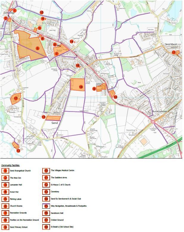
Send Neighbourhood Development Plan – Referendum Version

 Policy Send 7 – Supporting sustainable transport

Proposals that enhance sustainable and accessible transport opportunities and help
address the transport issues within Send Parish will be supported. Examples of these
could include:
a)     The provision or improvement of public transport facilities;
b)     The provision or improvement of public footpaths and cycleways;
c)     The provision of electric charging points at publicly accessible locations or
       within developments; and
d)     The provision of park and ride facilities for local stations.

 Policy Send 8 – Car parking provision

Proposals will only be supported where they provide off-street vehicle parking such
that the level of any resulting parking on the public highway does not adversely
impact road safety or the movement of other road users. This provision will apply the
standards set out in the Surrey County Council ‘Vehicular and Cycle Parking
Guidance’ as a minimum.

 Community Aspirations

 Community Aspiration 1 – Community Led Housing

To support the investigation of options for Community Led Housing in consultation
with the Borough Council’s housing team, including the option of setting up a
Community Land Trust.

 Community Aspiration 2 – Improvements to transport in Send

The Parish Council will seek to represent residents’ concerns about transport issues in
Send by doing the following:
   • lobbying the County Council and train and bus providers for the retention
      and provision of good public transport services and facilities;
   • lobbying the Local Transport Authority to provide improved facilities for
      pedestrians and cyclists;
   • lobbying the Local Transport Authority for measures to reduce traffic speed
      and congestion; and
   • engaging with the Council’s transport planners to see whether there are
      opportunities to identify further sustainable transport and air quality schemes.

                                                                                Page | 6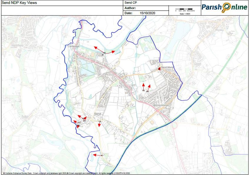
Send Neighbourhood Development Plan – Referendum Version

 Community Aspiration 3 – Voluntary involvement in maintaining green and blue
 spaces

To encourage local volunteer groups to assist with the maintenance of the natural
green and blue spaces and corridors including litter picking.

 Community Aspiration 4 – Registering Assets of Community Value

To submit applications to Guildford Borough Council to register the facilities listed in
Policy Send 6 as Assets of Community Value where they meet the qualifying criteria.

 Community Aspiration 5 – Local Heritage

To encourage local community groups with an interest in heritage to draw up an
inventory of historic buildings and other structures that may be worthy of either
national listing or local listing, and to submit this inventory to Historic England and/or
Guildford Borough Council as appropriate for assessment..

                                                                                   Page | 7
Send Neighbourhood Development Plan – Referendum Version

                                                           Page | 8
Send Neighbourhood Development Plan – Referendum Version
1.0 How to Read and Use the Send Neighbourhood Development
Plan
1.1 Neighbourhood Development Plans are a new type of document that enable
local people, who know and love the area, to write planning policies for their
area. A neighbourhood development plan cannot override national or local
authority policies; however, it becomes part of the legal planning framework
and works alongside national and local authority policies in determining
planning applications. Neighbourhood Development Plans are therefore
powerful documents.
1.2 The Send Neighbourhood Development Plan sets out a vision and the
objectives for the future of Send up to 2034 (time period in line with that of the
new Guildford Local Plan).
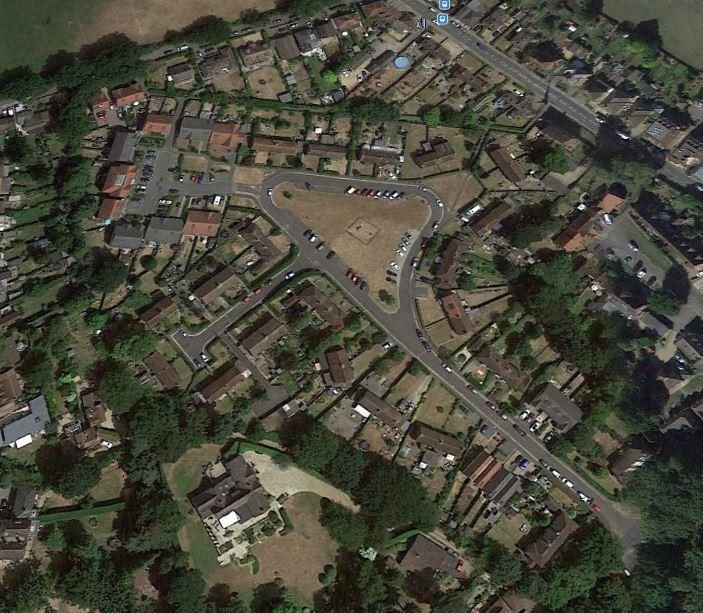
1.3 On 2nd July 2015, Guildford Borough Council designated a Neighbourhood
Area for the whole of the Parish of Send to enable Send Parish Council to
prepare the Send Neighbourhood Development Plan. The designated area is
shown below:
Send Neighbourhood Development Plan designated area
Page | 9Send Neighbourhood Development Plan – Referendum Version
1.4 A Non-Technical Summary has been inserted at the front of the Plan to
provide the reader with a quick summary of the planning policies and other
recommendations. The rest of the Plan has been set out as follows:
1. How to Read and Use the Send Neighbourhood Development Plan
2. Neighbourhood Planning: Legislative and Planning Policy Context
3. Community Consultation
4. The Parish of Send
5. Vision & Objectives
6. Planning Policies
7. Non-Statutory Community Aspirations
8. Delivery Plan
9. Appendices
1.5 This Plan, and its associated maps and policies should be used by residents,
local authorities, developers and other stakeholders to understand how the
local community wishes future development to occur. Attention should be
paid to the aspirations and objectives set out within this document, whether
or not the development requires planning permission. For applications that
require planning permission, whether proposing a scheme or assessing the
acceptability of a scheme, the policies contained within this document are
key. For a planning application to be considered favourably, all relevant
policies contained within this plan should be considered and complied with.
Page | 10Send Neighbourhood Development Plan – Referendum Version
2.0 Neighbourhood Planning: Legislation and Planning Policy
Context
2.1 The legislation and planning framework described below need to be seen
within the context of Government policy which in essence seeks to:
• Delegate decisions on planning as close as possible to local people;
and
• Address the severe shortage of homes to rent and to buy.
2.2 The Send Neighbourhood Development Plan must be in general conformity
with both national and local strategic planning policies. Neighbourhood
Development Plans are influenced by various higher-level plans, policies and
guidance. The legal basis for the preparation of Neighbourhood
Development Plans is provided by:
• the Localism Act 2011
• Neighbourhood Planning (General) Regulations 2012
• Planning and Compulsory Purchase Act 2004
• Directive 2001/42/EC on the assessment of the effects of certain plans
and programmes on the environment (SEA Directive) and
• the Town and Country Planning Act 1990.
2.3 The following is a summary of the key planning policy context for the Send
Neighbourhood Development Plan.
National Planning Policy the strategic elements of the
Framework Local Plan; and
• identify opportunities to
2.4 The National Planning Policy enable developments that
Framework (NPPF) 2019 sets out are consistent with their
the Government’s planning neighbourhood plan to
policies for England and how proceed.
they are expected to be
applied. At its heart is a Local Planning Context
presumption in favour of
sustainable development. The 2.5 The ambition of the
application of the presumption Neighbourhood Development
has implications for how Plan should be aligned with the
communities should engage in strategic needs and priorities of
neighbourhood planning. the wider local area.
Critically, it means that Neighbourhood plans must be
neighbourhoods should: in general conformity with the
• develop plans that support strategic policies of the local
the strategic development planning authorities. The key
needs set out in Local Plans, documents are:
including policies for housing
and economic • Guildford Local Plan 2003
development; (saved policies)
• plan positively to support • Guildford Local Plan to 2034.
local development, shaping
and directing development 2.6 The Guildford Local Plan to 2034
in their area that is outside was adopted on 25 April 2019
Page | 11Send Neighbourhood Development Plan – Referendum Version
prior to the examination of the progressing the adoption of a
Send Neighbourhood Charging Schedule for
Development Plan, and Community Infrastructure Levy.
therefore is the most critical This is a planning charge,
document in terms of introduced by the Planning Act
demonstrating general 2008 as a tool for local
conformity with the strategic authorities in England and
policies. It includes housing and Wales to help deliver
employment allocations for community infrastructure to
Send which are detailed in support the development of
Chapter 6. The Send their area. On-site infrastructure
Neighbourhood Development and affordable housing will
Plan cannot override these continue to be delivered
allocations. Because these through Section 106
allocations are of a significant agreements. Communities with
scale and planned to meet the a made neighbourhood
development needs for the development plan will receive
Borough up to 2034, the Send at least 25% of the Community
Neighbourhood Development Infrastructure Levy to spend on
Plan does not allocate further infrastructure in their areas.
development but rather seeks
to influence the type, style, Strategic Environmental
tenure and design of these Assessment and Habitats
allocated developments and Regulations Assessment
any other future windfall
developments1. 2.8 Guildford Borough Council has
screened the scope of the Send
Neighbourhood Development
The Link between Development Plan and determined that it
and Infrastructure does not require a Strategic
Environmental Assessment
2.7 Currently provision and
under the EU Directive 2001/42.
contributions towards
However, it will require a
infrastructure and affordable
Habitats Regulations
housing are secured via legal
Assessment because the parish
agreements known as Section
is within the zone of influence of
106 agreements which are
the Thames Basin Heaths
negotiated at the planning
Special Protection Area and
application stage. These can
therefore mitigation for
include financial contributions
development will be required.
towards local infrastructure
This assessment process will be
such as schools and libraries
undertaken by Guildford
and physical works such as
Borough Council before the
highway improvements. It is
Send Neighbourhood
understood that Guildford
Development Plan is submitted
Borough Council will be
for examination.
1
Mainly infill developments that comply with
policies in the Guildford Local Plan and the Send
Neighbourhood Development Plan.
Page | 12Send Neighbourhood Development Plan – Referendum Version
The Plan Preparation Process Purchase Act 2004. They are
that:
2.9 The process of preparing the
Send Neighbourhood 1. “Having regard to national
Development Plan is set out in policies and advice
the Neighbourhood Planning contained in guidance
(General) Regulations 2012. This issued by the Secretary of
comprises: State it is appropriate to
• Undertaking background make the neighbourhood
research and evidence plan;
baseline work, and informal 2. The making of the
public and stakeholder neighbourhood plan
consultation; contributes to the
• Publishing a Pre-Submission achievement of sustainable
Plan for a statutory six-week development;
public consultation period; 3. The making of the
• Revising the draft Plan neighbourhood plan is in
where appropriate in line general conformity with the
with consultee responses; strategic policies contained
• Submission of the Plan to in the development plan for
Guildford Borough Council the area of the authority.
for a legal check; 4. The making of the
• Publication of the neighbourhood plan does
Neighbourhood not breach, and is otherwise
Development Plan for a compatible with, EU
further 6 weeks by Guildford obligations.
Borough Council; 5. Prescribed conditions are
• Examination by an met in relation to the
independent Examiner neighbourhood plan and
appointed by the local prescribed matters have
planning authorities in been complied with in
consultation with Send Parish connection with the
Council (see section below). proposal for the plan”.
The Examination Process 2.11 With regard to Basic Condition 5
above, this includes that “The
2.10 The independent Examiner must making of the neighbourhood
consider whether the development plan does not
Neighbourhood Development breach the requirements of
Plan meets the ‘Basic Chapter 8 of Part 6 of the
Conditions’. The Basic Conservation of Habitats and
Conditions are set out in Species Regulations 2017(3)2.”
paragraph 8(2) of Schedule 4B This means that, if the
to the Town and Country neighbourhood development
Planning Act 1990 as applied to plan is likely to have a
neighbourhood development significant effect on a European
plans by section 38A of the protected site, such as Thames
Planning and Compulsory Basin Heaths Special Protection
2
The Conservation of Habitats and Species and Neighbourhood Planning (General) Regulations
Planning (Various Amendments) (England and 2012(1).
Wales) Regulations 2018 which amends The
Page | 13Send Neighbourhood Development Plan – Referendum Version
Area (SPA), even if that effect modified to make it
could be mitigated, a full compliant).
Habitats Regulations
Assessment of the plan needs to 2.14 If the examination is successful
be undertaken. then Guildford Borough Council
in consultation with Send Parish
2.12 The Examiner must also consider Council will consider making
whether other legislative any modifications
requirements are met namely: recommended by the
• “The Neighbourhood Plan Examiner. Guildford Borough
meets the requirements of Council will then make
Section 38B of the Planning arrangements for a referendum
and Compulsory Purchase of all the electorate in Send
Act 2004 (the Plan must Parish on whether the
specify the period to which Neighbourhood Development
it has effect, must not Plan should be used to help
include provisions relating to make decisions on planning
‘excluded development’, applications. If the referendum
and must not relate to more result is more than 50% ‘Yes’
than one Neighbourhood then Guildford Borough Council
Area) and will make the Send
• The policies relate to the Neighbourhood Development
development and use of Plan part of the statutory
land for a designated Development Plan for the area.
Neighbourhood Area in line
with the requirements of the
Planning and Compulsory
Purchase Act 2004 Section
38A”.
The Approval Process
2.13 The Examiner must recommend
one of three things:
• That the Neighbourhood
Development Plan goes
forward to referendum
unchanged;
• That the Neighbourhood
Development Plan be
modified and then goes
forward to referendum;
• That the Neighbourhood
Development Plan
should not go forward to
referendum (because it
does not meet the
legislative requirements
above and cannot be
Page | 14Send Neighbourhood Development Plan – Referendum Version
3.0 Community Consultation
3.1 The Send Neighbourhood Development Plan Working Group consists of parish
councillors and residents. The working group has identified 5 key areas: Design
and Development, Transport and Travel, Local Economy, Environment and
Facilities. Focus Groups were set up to gather information and evidence on
these areas to support emerging issues and concerns raised by residents.
3.2 As part of the plan making process, the Working Group and Focus Groups
have undertaken a number of public events as part of their consultation
activities. These open days were advertised to the residents through flyers,
websites, notice boards and local publications.
3.3 In May 2015, Send Parish Council considered whether to prepare a
Neighbourhood Development Plan and announced its intentions on its stand
at the Annual May Fair. Once the decision to go ahead with the Plan was
taken, a launch event was organised in September 2015. The event
comprised displays of the key aspects of the proposed Plan and sought
attendees’ views.
3.4 In Autumn 2016, consultants (Tibbalds and Action in rural Sussex) were
appointed to support the Parish Council and its working groups to prepare
the plan and in late November 2016 there was a walkabout to familiarise
Tibbalds with the Parish.
3.5 The preparation of the Neighbourhood Development Plan, the Consultation
Process and the timing and location of events have been advertised via a
number of varied methods in the hope of reaching as many different groups
of residents and individual residents as possible. These methods include but
are not limited to a website, regular newsletters, Parish noticeboards, updates
at Parish Council meetings, use of local social websites, village Facebook
Page, word of mouth and parish wide surveys.
3.6 Consultations were designed to ask open questions of the community
regarding their likes and dislikes regarding the Parish, identify areas where
they thought the Parish could be improved and ask them what their vision of
Send was in 15-20 years’ time.
3.7 Presentations and appeals for volunteers using story boards as a backdrop
were made to the Send Amateur Dramatic Society attended by more than
200 people over its three performances. Presentations were also made to
some local Clubs & Societies including the Ripley and District Horticultural
Society and the local Rotary Club, many of whose members live in Send or
use its facilities. There was a manned neighbourhood planning stand at the
Clean-up Day organised by the Parish Council including display boards briefly
describing the Plan process and visitors to the stand were asked to indicate
where there lived and to comment on what they liked or disliked in the Parish
as well as what they would like to see improved in the Parish. They were also
given opportunities to comment on the proposed vision for Send.
Page | 15Send Neighbourhood Development Plan – Referendum Version
3.8 The Plan was re-launched at the Send Parish Council’s Annual Parish Meeting
which took place in early April 2017. Boards were displayed at the rear of the
Hall showing the scope and topics to be covered by the Plan and appealing
for volunteers for sign up to assist with the plan preparation. A presentation on
neighbourhood planning was delivered by Action in rural Sussex. A total of 75
people attended the meeting.
3.9 The Plan was also publicised at the Send May Fair held on Send Recreation
Ground on 2017 May Day Bank Holiday. There were opportunities for children
to enter a balloon painting competition whilst parents viewed the stands. At
least 70 members of the public visited the stand. There was a similar stand at
the Fair at the Send School in June 2017. The event was publicised by the
School, which advertised it to all parents and displayed a banner outside the
School. The stand was visited by approximately 30 adults. Members of the
Working Groups also attended the ‘Gone Country’ Music Festival held at the
Saddlers Arms in June 2017 to raise awareness about the Plan.
3.10 In spring 2018 a survey was developed and undertaken by Action in rural
Sussex working in conjunction with the Working Group. The survey was
conducted using a questionnaire consisting of both closed and open-ended
questions. This mix allows questions to focus on obtaining specific pieces of
information tailored at responding to certain issues or themes (closed
questions), whilst allowing a degree of freedom in the responses which
people provide (open questions).
3.11 A total of 1665 paper survey forms were distributed by post on the 23rd April
2018 to each household in Send Parish including pre-paid envelopes for
returns. There was also an option to complete the survey online via Survey
Monkey. Residents were asked to complete and return their forms by the 23rd
May 2018 (which was later extended to 31st May 2018) so that the results
Page | 16Send Neighbourhood Development Plan – Referendum Version
could be analysed. The same deadlines applied to those who aimed to
complete the survey online.
3.12 A total of 353 responses were received to the survey of which 294 were
returned by post and 59 completed online. This provides the survey with a
response rate of 21.2%.
3.13 In the summer of 2018 the Working Group in collaboration with Send Church
of England Primary School undertook a short and simple questionnaire with
pupils of 6-11 years. 16 completed forms were returned. An online survey with
businesses was also carried out aimed at businesses operating from and
within Send Parish as well as those working from home. The purpose was to
gather further evidence from this target group to help draw up policies about
local business in the Parish. 5 businesses responded to the survey of which 2
had been in operation for over 21 years, 2 had been operating between 10-
12 years and 1 had been operating between 6 months and 3 years so fairly
new.
3.14 The outcomes of the consultation activities referred to above are detailed in
the Consultation Statement published alongside this Neighbourhood
Development Plan. They have been used to inform the vision and objectives
set out in Chapter 5 of the Plan and the policies and community aspirations
set out in Chapters 6 and 7.
3.15 In the spring of 2019 a draft Send Neighbourhood Development Plan was
published for public consultation for 6 weeks between 8th April and 28th May
2019. The responses received informed the final version of the Plan submitted
for examination as detailed in the Consultation Statement.
Page | 17Send Neighbourhood Development Plan – Referendum Version
4.0 The Parish of Send
4.1 The Civil Parish of Send higher proportion of people
comprises the three settlements over 65, a lower proportion of
of Send, Send Marsh and Burnt those aged 16-64 and a lower
Common together with proportion of 20-44 year olds.
surrounding countryside. It is
located in the north-west corner 4.5 The population live in 1,700
of Guildford Borough in the dwellings, nearly 83% of which
centre of Surrey. Primarily a rural are owner-occupied.
area, the settlements are Compared to the rest of
bordered by both green belt Guildford Borough it has lower
and sections of the River Wey levels of social rented, private
which separate it from adjacent rented and shared ownership
settlements. It has a long history properties. A significantly higher
and was first recorded in the proportion of households
Doomsday Book of 1086 as occupy detached housing
Sande. (54.8%) when compared to the
rest of the Borough (33.6%). A
4.2 The Parish is adjacent to the significantly lower proportion of
main A3 road which runs north households occupy terraced
east to south west and forms its housing (5.3% compared to
entire southern border. This road 13.9%) and flats (7.0%
provides connectivity to compared to 19.3%) than the
Portsmouth via Petersfield and rest of the Borough.
Guildford (located
approximately 5 miles to the 4.6 The Census showed that
south west) and to the M25 economic activity rates of those
London Circular located aged 16-74 were slightly higher
approximately 5 miles to the in Send Parish than the Borough
north east. In addition, there are average and it had a slightly
A and B road links to nearby lower proportion of those who
villages and the towns of are full-time employees.
Guildford and Woking. Unemployment rates were
marginally lower than those for
4.3 Send has no train station of its the Borough. There were a
own, but the Parish is located higher proportion of people in
relatively close to Guildford, higher paid occupations
Woking, Worplesdon and West compared to the Borough
Clandon stations, which offer average. A survey carried out in
(stopping, semi-fast and fast) Send in 2018 found that nearly
main line rail services to London 76% of respondents travel
and to south coast destinations outside of Send to work, and
including Portsmouth and nearly 42% work from home for
Southampton. at least some of the time. Less
than 6% work at a business
4.4 The population of Send Parish premises within Send.
was 4,245 people at the time of
the 2011 Census. Compared to 4.7 According to the Census motor
the average for Guildford vehicle ownership in Send is
Borough, Send Parish had a high in comparison to the
Page | 18Send Neighbourhood Development Plan – Referendum Version
Borough average. Health levels
were similar to the average for
Guildford Borough.
4.8 Send is served by a range of
amenities and services. This
includes a Medical Centre, a
Primary School (The Village
Medical Centre and the Primary
School serve all three
settlements and a wider
geographical area of
neighbouring villages), a Post
Office, 2 Public Houses, 2
churches, meeting rooms, social
club, a recreation ground, two
well-equipped play areas and a
few retailers and eateries. In
addition to the amenities, the
community has a number of
active sports clubs and
community societies, including
a football club and cricket club.
4.9 There are two Sites of Special
Scientific Interest in Send, some
areas identified by Natural
England as Priority Habitats and
21 Grade II and two Grade II*
listed buildings. The parish is
within the zone of influence of
the Thames Basin Heaths
Special Protection Area (SPA),
which is a network of heathland
sites that covers 8,274 hectares
of Berkshire, Hampshire and
Surrey. The SPA provides a
habitat for three internationally
important bird species;
woodlark, nightjar and Dartford
warbler. The SPA is protected
from adverse effects under
European and UK law.
Page | 19Send Neighbourhood Development Plan – Referendum Version
5.0 Vision & Objectives
The Send Neighbourhood Development Plan Working Group has developed a vision
and a set of objectives for the plan. The vision and objectives came about as a
result of public consultation activities
Vision
By 2034, Send Parish will be vibrant and sustainable with a distinct
character, good facilities, a strong sense of community and retain a rural
village feel. Send will have an enhanced local centre and provide a mix of
housing types for all, whilst retaining the character, environmental and
heritage assets of the parish and separate identities of the various
settlements, which have not merged into surrounding towns and villages.
Objectives
1. Design and Development
a. Support the provision of a mix of dwelling types including in particular
smaller dwellings for young families or those downsizing, and encourage a
proportion of development which enables people to live independently
within their home.
b. Encourage and support sensitive design standards that reflect the rural
character of the Parish.
2. Transport and Travel
a. Support improvements to transport links and create measures to promote
and improve access for pedestrians and cyclists.
b. Provide more parking facilities (preferably on-drive/off road) within all new
developments and reduce traffic speed and congestion on our roads.
3. Local Economy
a. Support and promote the growth of our local centre and encourage new
business start-p premises and facilities within the centre.
4. Environment
a. Protect and enhance the natural and built environment in particular our
blue and green corridors, listed buildings, conservation areas and other
non-designated heritage assets.
LAYOUTSupport the conservation objectives of the designated habitats affected
b.
by development and activities within the Parish.
5. Facilities
a. Retain and improve existing facilities and support initiatives that meet the
changing needs of the Parish.
Page | 20Send Neighbourhood Development Plan – Referendum Version
6.0 Planning Policies
Introduction
6.1 This chapter sets out the planning policies that will be applied to applications
for planning permission. Some of the issues are also addressed in the
following chapter, which sets out aspirations for those matters which cannot
be addressed through the planning system.
6.2 As set out in Chapter 2, the Send Neighbourhood Development Plan must
have regard to national planning policy and be in general conformity with
the Guildford Local Plan. It does not need to duplicate matters already
covered by these existing policies but rather complements them by providing
local detail and clarifying how they should be applied in the specific
circumstances of Send Parish. Each policy is preceded by explanatory text
which refers to the national and Local Plan context and clarifies the intent of
the policy to aid decision-makers.
Design
6.3 The National Planning Policy Framework states in paragraph 124 that “The
creation of high-quality buildings and places is fundamental to what the
planning and development process should achieve. Good design is a key
aspect of sustainable development, creates better places in which to live
and work and helps make development acceptable to communities. Being
clear about design expectations and how these will be tested is essential for
achieving this. So too is effective engagement between applicants,
communities, local planning authorities and other interests throughout the
process”. In paragraph 125 it says “Plans should, at the most appropriate
level, set out a clear design vision and expectations, so that applicants have
as much certainty as possible about what is likely to be acceptable. Design
policies should be developed with local communities so they reflect local
aspirations and are grounded in an understanding and evaluation of each
area’s defining characteristics. Neighbourhood plans can play an important
role in identifying the special qualities of each area and explaining how this
should be reflected in development”.
6.4 The Guildford Local Plan includes Policy D1: ‘Place shaping’, which includes
the requirement that “All new developments will be required to achieve high
quality design that responds to distinctive local character (including
landscape character) of the area in which it is set” and that “Proposals will
take account of local design guidance contained within conservation area
appraisals, DPDs, neighbourhood plans and SPDs”.
6.5 In order to assist the appropriate application of the above policy in Send, a
Character Assessment has been produced which describes the distinct
appearance and feel of Send and communicates the key physical features
and characteristics that combine to give Send its local distinctiveness and
unique identity. This assessment has been carried out using a combination of
approaches in the 2004 Natural England guidance “An Approach to
Landscape Character Assessment” and Planning Aid England’s “Character
Page | 21Send Neighbourhood Development Plan – Referendum Version
assessment – Putting the pieces together”. It drew on the results of the 2018
public survey, which asked people to identify what they valued about Send
and was carried out by a group of residents who surveyed the area and
identified the key characteristics. This work was assisted by Action in rural
Sussex, who pulled the information together into the published assessment.
This work was then verified by Guildford Borough Council to ensure that it was
accurate, clear and user-friendly for developers and decision-makers.
Representations made during the Regulation 14 public consultation also
informed the Character Assessment.
Policy Send 1 – Design
High quality and sustainable design is expected in Send and shall conserve and
enhance its heritage and environmental assets including the Wey & Godalming
Navigations Conservation Area and its setting. All development proposals will be
expected to demonstrate how they promote and reinforce the local
distinctiveness and high quality built and natural environment of Send with
reference to the Send Neighbourhood Development Plan Character Assessment.
Proposals should seek to ensure that development does not result in significant
adverse effects on the key views identified in the maps on pages 25 to 32 and
respects and retains key natural landscape assets. In particular, in the following
Character Areas:
A) Wey Navigation and River Wey – proposals must conserve and enhance the
Wey & Godalming Navigations Conservation Area;
B) A247 and Sanger Drive – proposals must retain its open green feel with wide
verges and trees, stretches of hedging and swathes of wild-flowers and daffodils;
C) Church Lane, Vicarage Lane and Woodhill – proposals must retain and
respect the very attractive buildings, the beautiful and ancient church and
graveyard, and the stud farm;
D) Potters Lane and Fishing Lakes – proposals must reflect its rural and unspoilt
character with many trees and beautiful lakes and very little light pollution;
E) Send Hill – proposals must reflect its very green and rural character as a result
of many mature trees and hedges;
F) Tannery Lane – proposals must retain its country lane character and rights of
way through farmland linking to Send Marsh Road and beyond;
G) Polesden Lane, Send Marsh Green and Send Marsh Road (west) – proposals
must demonstrate how they have been designed to conserve, or where possible
enhance, the significance of the oldest surviving buildings in Send, many of
which are listed, and the oldest part of the village at Send Marsh Green;
H) Send Marsh Road (south) and Send Marsh Estate – proposals must reflect the
variety of two storey dwelling types in this area;
Page | 22Send Neighbourhood Development Plan – Referendum Version
I) The area from the stream by the Villages Medical Centre along Send Barns
Lane including the roads to the left and Boughton Hall Avenue - proposals must
include retaining the open and green appearance of the roads leading off Send
Barns Lane where the majority of the front gardens are open-plan with the rest
having low hedges in a setting of mature trees. Proposals must include the
retention of grass verges along Send Barns Lane and along the roads leading off
it except where highways improvement schemes may be required. Boughton
Hall Avenue proposals must retain the generous number of mature trees along
both sides of the road and in private gardens with the low level density
character of trees, hedges and large gardens in the area;
J) Portsmouth Road, Burnt Common (south)and Clandon Road – outside of the
Local Plan strategic housing allocation, proposals should reflect the variety of
styles in this area, and in the whole of area J) the aim should be to retain the
healthy mature trees along the roads;
K) Fell Hill and Potters Lane South – proposals must reflect its rural character of
farmland and woodland with scattered development;
L) London Road – proposals must retain the trees and hedges along both sides of
the road;
M) Sandfields – proposals must retain the green character and open space,
particularly the Upper Sandfields Green.
Page | 23Send Neighbourhood Development Plan – Referendum Version
Send NDP Character Areas map
Page | 24Send Neighbourhood Development Plan – Referendum Version
Page | 25Send Neighbourhood Development Plan – Referendum Version
G1, G2 and G3
A1 and A2
C5, D1, D2, D4 and D5 K1
Page | 26Send Neighbourhood Development Plan – Referendum Version
Area A –Justification – The views A1 and A2 illustrate the function of the Wey Navigation as they demonstrate the varied nature of the environment. The
Broadmeads is a flood plain and here the Wey Navigation is higher than the River Wey and historically protects land and associated traditional buildings
such as the Tannery on the south side of the canal.
A1 - Looking over Wey Navigation towards the Tannery from
Highbridge (View A1)- From High Bridge, in Winter, you can see
toward the historic ruins of Woking Palace
A2 - Looking over Wey Navigation from Highbridge over Broadmeads
towards Old Woking (View A2)
Justification – The views from the Navigation are peaceful with a wide range of wildlife on an ever-changing landscape. There is grazing land for
cattle and this area often floods in winter.
Page | 27Send Neighbourhood Development Plan – Referendum Version
Area C - Justification – C5 Beautiful views are across open farm land with varied crops during the seasons.
C5 - Views from Vicarage Lane looking towards Surrey Hills from footpath
(FP 62)
Page | 28Send Neighbourhood Development Plan – Referendum Version
Area D - Surrounded by farmland and beautiful countryside views with many trees and hedgerows from Footpath 61 (in Area C) across fields in (Area D
D1 - Views from St Mary the Virgin churchyard looking across fields D2 - Looking across water meadows towards Wey navigation from
footpath (FP 61)
Justification D1 and D2 – There are lovely countryside views across the river valley, open fields and water meadows to the Surrey Hills
beyond.
Page | 29Send Neighbourhood Development Plan – Referendum Version
D4 - Church Lane looking towards Potters Lane Send Hill from FP 61 -
Justification – This open outlook is across the meadows and up to hill
with a variety of vegetation
D5 – A typical view towards the Surrey Hills from St Mary’s churchyard.
Page | 30Send Neighbourhood Development Plan – Referendum Version
Area G – A very rural view with features showing the historical moated site, Manor House and the Green. Justification – G2 G3 These countryside views
from a public footpath (F42) with open fields, hedgerows, trees and ancient moated site provide a peaceful outlook.
G3 - Views over Send Marsh (with trees marking
G2 - Views over Send Marsh (with trees marking Moat location) towards Aldertons from Moat location) towards Woking from FP42
FP42
Page | 31Send Neighbourhood Development Plan – Referendum Version
G1 - The Manor House and Green - Justification – A lovely open aspect across a village
green in one of the oldest parts of Send and includes a number of listed buildings on its
perimeter which are an important part of the character of this area
Area K - From Three Fords views over the fields toward the Wey Navigation
K1 - Potters Lane /near three
fords Looking west towards the
Wey
Justification – The open views
across farm land, grazing areas
and water meadows towards
the River Wey provide an
attractive backdrop to the busy
roads surrounding.
Page | 32Send Neighbourhood Development Plan – Referendum Version
Housing
6.6 The Guildford Local Plan includes the following housing allocations within
Send Parish:
• A40 Clockbarn Nursery, Tannery Lane, Send – 60 C3 homes;
• A41 Land at Garlick's Arch, Send Marsh Burnt Common and Ripley
Send and Lovelace - 550 C3 homes and Travelling Showpeople plots;
and
• A43 Land west of Winds Ridge and Send Hill 40 C3 homes; and 2
Travellers plots.
6.7 Guildford Local Plan Policy H2: Affordable homes says that the Borough
Council will seek affordable homes on sites providing 11 or more homes
(gross), or where dwellings would have a combined gross internal floor space
of more than 1,000 square metres. The Council will seek that at least 40% of
the homes on these sites be affordable homes, with a tenure split of at least
70% Affordable Rent, with the remainder being other forms of affordable
housing.
6.8 Previously, the whole of Send Parish was within the Metropolitan Green Belt,
where development will not be permitted unless very special circumstances
can be demonstrated. However, the new Guildford Local Plan ‘inset’ (or
removed) the settlements of Send, Send Marsh and Burnt Common from the
Green Belt. The map below shows the revised boundary of the Green Belt
around Send. Windfall development can come forward on sites within the
inset areas subject to the design and other detailed policies of the Local Plan.
As at July 2019 planning applications for 59 additional homes had been
submitted in these areas over and above those allocated in the Local Plan.
Such windfall development may erode the character of the village and
place strain on local services and infrastructure.
6.8A Within the Green Belt the NPPF makes it clear that the construction of new
buildings is generally inappropriate. However, exceptions to this include
limited infilling in villages; limited affordable housing for local community
needs; and the partial or complete redevelopment of previously developed
land (NPPF paragraph 145). Policy P2 of the Local Plan allows ‘limited infilling’
“where it can be demonstrated that the site should be considered to be
within the village”. Limited infilling is defined as “the development of a small
gap in an otherwise continuous built-up frontage, or the small-scale
redevelopment of existing properties within such a frontage. It also includes
infilling of small gaps within built development”.
Page | 33Send Neighbourhood Development Plan – Referendum Version
Boundary of the Greenbelt around Send settlements
6.9 Guildford Local Plan Policy H1: ‘Homes for all’ requires new residential
development to deliver a wide choice of homes to meet a range of
accommodation needs as set out in the latest Strategic Housing Market
Assessment. New development should provide a mix of housing tenures, types
and sizes appropriate to the site size, characteristics and location. The policy
includes requirements for certain types of specialist housing but does not set
specific targets for unit sizes. However, in Send there is evidence from the
Census 2011 that the existing proportion of housing stock that is smaller and
more affordable units is significantly below the Borough average.
6.10 The West Surrey Strategic Housing Market Assessment (SHMA) 2015 and
Addendum Report 2017 identifies a need for the following types of dwellings:
• Affordable homes - 40% one bedroom, 30% two bedroom, 25% three
bedroom and 5% four bedroom; and
• Open market homes - 10% one bedroom, 30% two bedroom, 40% three
bedroom and 20% four bedroom.
6.10a Guildford Local Plan Policy H3: ‘Rural exception homes’ allows for small scale
affordable housing developments in the Green Belt, to meet identified local
affordable housing needs subject to a number of criteria including that the
affordable homes are all secured in perpetuity. Because Send is not
categorised as a ‘rural area’ under the (Designated Rural Areas in the South
East) Order 1997, affordable housing in this parish is not exempt from the right
to acquire or right to enfranchise, and therefore cannot automatically be
Page | 34Send Neighbourhood Development Plan – Referendum Version
secured in perpetuity through the legislation. In order for a rural exception
scheme to be granted planning approval in Send, the housing provider will
have to demonstrate that mechanisms are in place to ensure that the
properties remain as affordable housing in perpetuity, for example being held
in a Community Land Trust and let on terms which would not allow the
freehold to be acquired by the resident and/or sold on the open market.
Policy Send 2 – Housing Development
Housing development in Send Parish will be supported provided that:
a) It is on site allocated in the Local Plan or other subsequent Development
Plan Documents which complies with the development guidelines or briefs
adopted by Guildford Borough Council; or
b) Within the settlements of Send, Send Marsh and Burnt Common inset from
the Green Belt it comprises development that reflects the character and
settlement pattern of the surrounding area and avoids or mitigates
increased pressure on community or transport infrastructure in the area; or
c) Within the Green Belt it comprises development that complies with the
exceptions set out in paragraphs 145 and 146 of the NPPF; or
d) It is a rural exception site which complies with Policy H3 of the Guildford
Local Plan.
Page | 35Send Neighbourhood Development Plan – Referendum Version
Local Economy
6.11 The Guildford Local Plan includes the following employment allocation within
Send Parish:
• Policy A45: Land around Burnt Common warehouse, London Road, Send -
for a minimum of 14,800sq m of either or a mix of light industrial (B1c),
general industrial (B2) and storage and distribution (B8) over the Plan
period with the potential for further industrial floor space etc. to meet
future borough needs, as identified through subsequent updates to the
Employment Land Needs Assessment (ELNA).
6.12 The Guildford Local Plan E3: ‘Maintaining employment capacity and
improving employment floorspace’ also identifies a ‘Strategic Employment
Site’ at Send Business Centre/Tannery Studios Tannery Lane, Send and
confirms that, once developed, the new employment land at Burnt Common,
together with the existing employment floorspace, will be treated as an
Industrial Strategic Employment Site. It also protects such areas and says that
their loss will be strongly resisted subject to robust evidence of marketing. This
policy also protects other existing employment uses from redevelopment to
non-employment uses unless the land or premises is unsuitably located in
terms of its impact on the environment, levels of traffic movement, its
accessibility to public transport and its link with the infrastructure, and its
impact on the amenity of the area or adjoining occupiers.
6.13 The local shopping centre in Send is also an important part of the local
economy, providing retail and other economic activity alongside community
facilities. Guildford Local Plan Policy E9: ‘Local Centres and isolated retail
units’ recognises Send as having a ‘rural Local Centre’ where proposals for
retail and other main town centre uses consistent with the scale and function
of that centre will be supported and changes of use are controlled (where
these require planning permission).
Policy Send 3 – Supporting the local economy
In addition to the Strategic Employment Sites in Guildford Local Plan, proposals for
new business or retail development of under 100sqm (gross) within the settlements
of Send, Send Marsh or Burnt Common will be supported provided that:
a) the site is suitably located in terms of its impact on the environment, levels
of traffic movement, its accessibility to public transport and its link with the
infrastructure, its impact on the amenity of the area or adjoining occupiers;
and
b) if the site is within or adjacent to Send Local Centre, as defined on the
Policies Map, it supports the existing uses within that Centre and its role as a
community hub.
Page | 36You can also read