SOCIO-ECONOMIC AND ENVIRONMENTAL IMPLICATIONS OF GOLD PANNING ACTIVITIES IN NORTHERN PALAWAN, PHILIPPINES
←
→
Page content transcription
If your browser does not render page correctly, please read the page content below

BIMP-EAGA Conference 2012

     SOCIO-ECONOMIC AND ENVIRONMENTAL IMPLICATIONS OF
       GOLD PANNING ACTIVITIES IN NORTHERN PALAWAN,
                        PHILIPPINES
  Maria Rosario Aynon A. Gonzales, Agustin R. Miraflores, Jr., Rhoda Roque, Alejandro Bernardo, Jr.,
 Honesto R. Teves, Mariane Faith M. Perez, Glenda M. Cadigal, Cherry Lyn S. Jalover, Ramon Docto,
                                          Jeter S. Sespeñe
                    Palawan State University, Puerto Princesa City, PHILIPPINES
                                 (email: ayna_agustin@yahoo.com)

                                               ABSTRACT

        This study assessed the “unregulated” small-scale gold panning activities of the Northern
        Palawan Gold Panners Multi-Purpose Cooperative (NORPAGOP-MC) in Roxas,
        Palawan, Philippines. The project site was formerly an agricultural area before its
        conversion into a mining area. Such conversion was largely financially-driven: the site
        price of gold dust was recorded at US$ 29.71/gram, making the average household
        monthly income at US$ 327.50, which is much higher than the income derived from
        farming. Methodologically, rapid environmental appraisal was conducted. This was
        complemented by key informant interviews and focused group discussions to assess the
        income of the members. Those who were engaged in gold panning activities included
        NORPAGOP-MC household members as young as six years old. Negative impacts to the
        environment include the continuous depletion of topsoil, which makes the area less
        suitable for agricultural crops and the siltation of Iraan River. The silt eventually drains
        into the coastal area that physically smoother some of the coral reef areas. The mined-out
        areas pose danger to the resident population and livestock. Apparently, the absence of
        mitigating measures - such as reforestation program and siltation ponds -has transformed
        the gold panning activities into an unsustainable development endeavour.

        KEY WORDS: Gold Panning, Cooperative, Roxas Palawan

 1.0 INTRODUCTION

Palawan hosts to some of the biggest mining companies in the Philippines because of its richness in
mineral resources such as nickel, chromite, manganese, gold and others. Mining activities require the
clearing of large areas of land. The process of extracting metals and minerals from the earth would change
the land formation and affects the biodiversity of some species of plants and animals.

Section 4 of R.A. 7176, known as the People’s Small-scale Mining Act of 1991, establishes a People’s
Small-scale Mining Program “designed to achieve an orderly systematic and rational scheme for the
small-scale development and utilization of mineral resources in certain mineral areas in order to address
the social, economic, technical, and environmental problems connected with small-scale mining
activities” (DENR, Republic Act 7176, 1991).

One of the small-scale gold panning activities in Palawan is situated within the municipality of Roxas,
Palawan. The municipality of Roxas is located in the north-eastern part of the province. It is
geographically located at 10º19’30” North, 119º20’44” East. The area presents a variety of land cover.

                                                                                                        1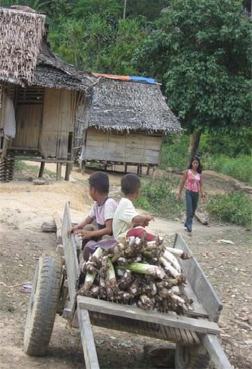
BIMP-EAGA Conference 2012

The moderately flat to rolling terrain accommodates a diverse species of plant varieties. The low-lying
areas are typically suited to agriculture while rolling hills favour some fruit-bearing trees like cashew
(Anacardium occidentale)and citrus(Citrus mitis)family trees. Coconut (Cocos nucifera) trees in some
areas evidently thrive well. It is home to second growth and patches of forest cover in the upside portion
of the project site and abounds with conventional forest trees and herbs to fruit bearing trees planted by
the early inhabitants of the area. The forest cover provides the thin cover of the watershed which supplies
the water demand of all the stakeholders including that of plants and animal species. The river displays
relatively wide distance between banks indicative of greater amount of water that flows during rainy
season.

Based on the existing Environmentally Critical Areas Network (ECAN) policy of the Palawan Council for
Sustainable Development (PCSD), mining activities may be allowed in at least the controlled Use Area.
For Multiple Use Zone, the uses that may be allowed, though not limited therein, are “timber extraction
with community-based forest management, grazing and pastures, agriculture, infrastructure and
industrial development, recreation, education, research and other sustainable human activities. However,
certain development endeavors maybe subject to the EIA system and to other pertinent laws and rules”
(PCSD, 2010).

This study focused on the assessment of the socio-economic and environmental implications of the
“unregulated”small-scale gold panning activities within a ten-hectare parcel of land in Sitio Iraan,
Magara, Roxas, Palawan. It was conducted from April to June 2010. This small-scale gold panning is one
of the economic activities of the people in barangay Magara and managed by the Northern Palawan Gold
Panners Multi Purpose Cooperative (NORPAGOP-MPC). The members include economically
marginalized men and women and even children as young as six years old. The “unregulated” gold
panning activities existed for almost 20 years at the time of the conduct of the study.

      1.1.       Objective of the Study

 The study aimed to determine the socio-economic effects of the ‘unregulated” gold panning activities in
 Sitio Iraan, Magara, Roxas, Palawan, Philippines. Specifically, it aimed to:

             1. evaluate the impacts to soil and land cover where the gold panning activities is located,
             2. identify the present condition of the flora and the fauna in the mined sites,
             3. determine the present condition of the river that extends up to the Marine Protected Area
                in the adjacent village, and
             4. determine the socio-economic impact of the gold panning activity.

      1.2.       Conceptual Framework

On the basis of evaluating the socio-economic and environmental implications of the unregulated gold
panning activities in Northern, Palawan, the researchers used the framework illustrated below.

                                                                                                         2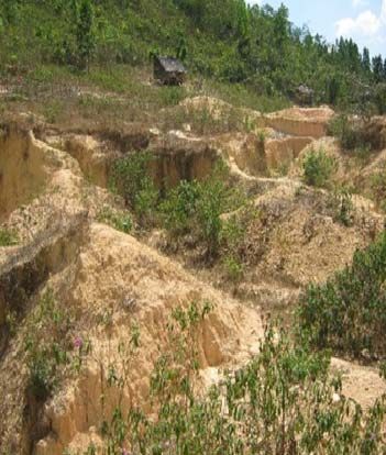
BIMP-EAGA Conference 2012

 2.0 METHODOLOGY

Rapid environmental appraisal was used in the conduct of the study to determine the current state of the
immediate environment of the project site. This form of assessment is undertaken by gathering
information from a variety of sources, by completing a series of short descriptions and checklists, and by
analysing, discussing and synthesising the findings. This was complemented by key informant interviews
and focused group discussions in accordance with the guidelines in the DENR Administrative Order
(DAO) No. 03-30, Revised Procedural Manual to assess the previous state of the environment prior to the
gold panning activities as well as the income of the members(DENR, 2003). Secondary data from PCSD
and Provincial offices were used to validate the previous status of the study area.

        2.1. Site Description

The municipality of Roxas, Palawan is geographically located at 10º19’30” North and 119º20’44” East
shown. Figure 2 illustrates the map of Palawan where the municipality of Roxas in the province of
Palawan is located. Barangay Magara, the study site, has a total land area of 4,157 hectares representing
3.5% of the total municipal land area. About 66% of its total land area is forest while 32% are considered
agricultural (Roxas Municipal Profile, 2009). The rest are built-up areas, open and idle lands. The mining
site is a ten hectare parcel of land formerly agricultural before its conversion to a small-scale mining area.
Large portion of the panning site is a coconut plantation mixed with various kind of vegetation. In the
upper portion of the area, almaciga (Agathis philippinensis) are being collected by the residents as other
means of livelihood. There are also agricultural lands at the lower portion of gold panning activity.

                                                                                                            3
BIMP-EAGA Conference 2012

        2.2. Respondents Profile of the study

The respondents of the study are from barangay Magara in the municipality of Roxas, province of
Palawan. It has a total population of 1,881 and composed of 406 households of which 347 (85.46%)
households are below the regional poverty threshold of the Philippines (CBMS, 2008). They are also
members of Northern Palawan Gold Panners Multi-Purpose Cooperative composed of 319 members of
which 220 are engaged in the gold panning activities while the rest are into different livelihood projects
like, sari-sari (variety) store, piggery, gardening and others. The members are marginalized that include
52% (165) men and 48% (154) women and even children as young as six years old. The people in the
community are from various ethnic groups such as Ilonggo, Ilocano, Cebuano, Cuyunon,Tagalog and
Tagbanua and most of them are tenured migrants.

        2.3 Research Design and Data Collection

A descriptive-survey design was used in this study. Rapid environmental appraisal with key informant
interview (KII) and focused group discussion (FGD) were used in data collection. In addition to the
survey questionnaires, relevant literature and/or copies of other documentary materials were secured from
the respective local government offices. Secondary data collection started on April 2010. This was
followed by a reconnaissance survey on May to June 2010.

A 1 km transect walk was
done to determine the flora
species present in the area.
Data collection on the
faunal species was made
using 1 km transect walk
whereby birds and other
wildlife were counted based
on sightings, calls, or
vocalization    of    birds,
evidences such as droppings
and foot tracks. Interviews
with local people were also
made based on their past
experiences.

Measurements       of   pH,
dissolved oxygen, total
dissolved solids, salinity,
conductivity            and
temperature were done on
site using the YSI 556
multiprobe meter. Samples
collected were analyzed at
the PCSD Environmental
Laboratory for parameters
such as total suspended
solids,    turbidity,   and
chromium         hexavalent.
Figure 3 shows the map of
the sampling stations.

                                                                                                        4
BIMP-EAGA Conference 2012

 3.0 RESULTS AND DISCUSSION

The results of this study are divided into 5 components. The following identified impacts threaten the
steady flow of ecosystem goods and services/functions of the land, river, coasts and the socio-economic
status of the resident population in the study area.

         3.1 Impact to Soil Stability and Land Forms

The extraction of soil altered the ground conditions that entailed the
loss of vegetation. The natural and aesthetic characteristics of the area
were changed. The system of operation of the gold panning activities
is mostly manual in nature. It involves direct extraction of gold dust
from the soil using shovels, pick mattock, digging bars, wooden pan,
bolo and water pump with engine used for washing the aggregates
                                           and pumping out of water
                                           from the excavation.

                                            Open pits as deep as 8
                                           meters below the natural
                                           grade line were observed to
                                           have no retaining walls that
                                           resulted to the collapse of
                                           walls and soil erosion
                                           during rainy season. The effect is minimal during dry season.
                                           The excavated materials were piled on the side of the
                                           excavation and are laid with canvas. The washing of the piled
                                            mixture of soil, gravel, and sand was done inside the
                                            excavation area to separate the sand particles from soil. The
                                            remaining sand particles were subjected to panning done
                                            outside the pit by continuous washing to ultimately separate
                                            the gold dust from the sand particles that will settle at the
                                            bottom of the pan as shown in figure 4. There were also
                                            operations adjacent to rivers noted that caused change in the
                                            direction and velocity of the stream as shown in figure 5. The
                                            mined out areas as shown in figure 6 left open pits that poses
                                            danger to human and animal lives. Likewise, the manner of
                                            extraction and leaving the mined out areas open also resulted
                                            to unable to plant crops. Laterite contamination of the
                                            farmlands at the lower portion of the mine area was also noted.
                                            The mining activity evidently altered the forest landscape that
                                            caused destruction of forest vegetation cover.

                                            3.2. Present Condition of the Flora

The survey site is moderately flat to rolling terrain which has second growth vegetation. Observed
vegetation in the area is illustrated in Table 1 with their scientific names based from the book Guide to
Philippine Flora and Fauna (Alcala, 1986).

TABLE 1. List of Flora Present in the Area

                                                                                                         5
BIMP-EAGA Conference 2012

  Common Name        Scientific Name              Common Name                Scientific Name
  1. Acacia          Acacia haloservicea A. Cunn. 13. Langka                 Artocarpusheterophyllus
  2. Alagao          PremnaOdorata                 14. Malacatmon            Tetracerascadens
  3. Arrow root      Marantaarundinacea            15. Mangium               Acacia mangium
  4. Auri            Acacia auricoliformes         16. Marang                Artocarpusodoratissimus
  5. Balete          FicusbaleteMerr.              17. Pandan                Pandanustectorius
  6. Banaba          Lagerstroemia Speciosa        18. Rattan                Calamus sp.
  7. Calamansi       Citrus microcarpa             19. Robusta Coffee        Coffeacanephora
  8. Coconut         Cocosnucifera                 20. Saging                Musa acuminata
  9. Dalupaan        VaccinumirigaenseMerr.        21. Saging-Saging         Aegicerascomiculatum (L.)
  10. Ferns          Sticheruslaevigata            22. Sambong               Blumeabalsamifera
  11. Guava          PsidiumGuajava                23. Tagbak                Alpiniaelegans
  12. Kandis         Garciniabinucao               24. Tree fern             Cyathea spp.

The different species shown in the table are scattered across the fragmented patches of second growth
forest across the area. The decrease in plant vegetation along the rivers and its immediate periphery
reduced the abundance, diversity and richness of flora in the area.

        3.3 Present Condition of the Fauna

Fragmentation in the area due to the small scale gold panning activities displaced some of the wildlife and
lost their habitats. Table 2 below shows the faunal species found to be present in the study area after its
conversion to a mining area. The pollution of the river led to the loss of aquatic organisms including
fishes and endemic wildlife. It is worth noting that the wildlife has moved to a more critical area driven
by the gold panning activities.

TABLE 2. List of Observed Fauna in the Area
  Common Name            Scientific Name              Common Name             Scientific Name
                                                      20. Pygmy
       AVIAN                                              Flower        Dicaeumpygmaeum
                                                          Pecker
 1. Asian Glossy                                      21. Rufous Tailed
                        Aplonispanayensis                               Orthotomussericeus
     Starling                                             Tailorbird
 2. Black Headed                                      22. Slender
                        Pycnonotusatriceps                              Corvusenca
     Bulbul                                               Billed Crow
 3. Blue Headed
                        Prioniturusplatenae           23. Spotted Dove     Streptopeliachinensis
     Racquet Tail
 4. Blue Naped                                        24. Striped Tit
                        Tanygnathuslucionensis                             Macronousgularis
     Parrot                                               Babbler
 5. Brown Backed                                      25. Reddish
                        Hirundapusgiganteus                                Macropygiaphasianella
     Needletail                                           Cuckoo Dove
 6. Common
                        Chalcophapsindica                 MAMMALS
     Emerald Dove
 7. Greater
                        Chrysocolapteslucidus         1. Bearded Pig       Sus barbatusahoenobarbus
     Flameback
 8. Green Imperial                                    2. Common
                        Duculaaenea                                        Paradoxurushermaphroditus
     Pigeon                                              Palm Civet
 9. Grey cheeked                                      3. Long Tailed       Macacafascicularisphilippine
                        Crinigerbres
     Bulbul                                              Macaque           nsis
 10. Hill Myna          Graculareligiosapalawan       4. Malay Civet       Viverratangalunga

                                                                                                          6
BIMP-EAGA Conference 2012

   Common Name               Scientific Name          Common Name                Scientific Name
                        ensis
                                                     5. Palawan
 11. Hooded Pitta       Pitta sordida                                     Arctictis binturong whitei
                                                        Bearcat
                                                     6. Palawan
 12. Jungle Fowl        Gallus gallus                                     Manisculionensis
                                                        Pangolin
                                                     7. Palawan
 13. Little Egret       Egrettagarzetta                                   Hystrixpumila
                                                        Porcupine
 14. Little Spider
                        Arachnotheralongirostra      8. Stink Badger      Mydausmarchei
     Hunter
 15. Olive Backed
                        Nectariniajugularis              REPTILES
     Sunbird
 16. Olive Winged                                    1. Box Pond
                        Pycnonotusplumosus                                Couraamboinensis
     Bulbul                                             Turtle
 17. Palawan Flower                                  2. Monitor
                        Prionochilusplateni                               Varanussalvator
     Pecker                                             Lizard
 18. Palawan
                                                     3. Palawan
     Peacock            Polyplectronemphanum                              Siebenrockiellaleytensis
                                                        Forest Turtle
     Pheasant
 19. Pink Necked                                     4. Reticulated
                        Treronvernans                                     Python reticulatus
     Green Pigeon                                       Python

        3.4 Present Condition of the Water Quality in Busay Creek and Iraan River

Grab samples of river water that were collected from 2 sampling stations (Figure 3) are presented in Table
3. Table 4 showed results of the water quality analysis of the river.

TABLE 3.Water Quality Sampling Stations
Station     Sample Source                                 Description
1       Busay Creek           End of PVC pipe that conveys water from the Busay Creek to the
                              community. Approximately 500 m.
2       Iraan River           Part of Iraan River, adjacent to the gold panning area

TABLE 4. Summary of Water Quality Data
                             Station 1
                                                            Station 2               WQ Criteria
Parameter                    (PVC Pipe from
                                                            (Iraan River)           (DAO 34/Class A)
                             Busay Spring)
Ph                           6.58                           6.58                    6.5 – 8.5
              0
Temperature, C               35.25                          36.11
Dissolved Oxygen, mg/L       2.46                           5.06                    5
Total Suspended Solids, mg/L
BIMP-EAGA Conference 2012
All water quality parameters measured and analyzed are within the DENR AO 34- Water Quality Criteria
for Class A except for the concentrations of TSS and Color from Station 2. These concentrations indicate
that the Iraan River is highly silted (Figure 5), already unfit for domestic purposes.
The gold panning activity which involved thorough washing of soil aggregates go directly to the river
affected as far as the marine protected area of the nearby barangay (village) and the surrounding shore
environment reduced the quantity, quality, and health of marine habitats and resources therein. Absence
of siltation ponds or any other measures to mitigate river pollution have been observed.
3.5 Socio-Economic Impact of the Gold Panning Activity
There were about 220 members who are directly engaged in gold
panning activities during the conduct of the study. Women and
children (aging at least 6 years old) are doing panning to support
their daily consumptions and allowance of children in going to
school. Based on the interview, an average of 5 members of the
household are performing the gold panning activities making an
average household monthly income of US$ 327.50, compared to
farming wherein revenues were derived from coconut, harvest of
grains, livestock and vegetables only amounted to an average
household monthly income of US$176.74. The respondents also
revealed that coconuts have smaller nuts that resulted to lower
average yield of 1.2 tons per hectare as compared to the national
average yield of 4.3 tons per hectare. Based from their accounts,
coconut trees do not produce comparatively than those planted at the
coastal areas hence for them it is better to mine the areas than to
plant coconuts and other crops.
Data on housing revealed 1 out of 40 households were living in
makeshift houses. The gold panners are staying in temporary
shanties made of coconut shingles whenever they perform the
panning operation. The survey further revealed that 31 households
have no access to improved water supply. The spring served as the
main source of water for bathing and drinking purposes due to the
fact that the river could no longer supply safe water for household
consumption as reflected in the water quality assessment (Table 4).
Forty four households were noted to have no sanitary facilities while
20 households were also reported to have malnourished children
aged 0-5. The communities never experienced being visited by
government and non-government organizations. Hence, diarrhea is
the major cause of mortality in all the areas, followed by urinary
tract infection and pulmonary diseases. Gastro-intestinal and skin
diseases have also been observed and may continue to exist if poor
environmental conditions persist.
The survey results further showed that 43 children aged from 6-12
are not attending elementary education and 46 children aged 13-16
were also noted to have not attended high school. The elementary
school is 4 to 5 kilometers away from the study area.
8BIMP-EAGA Conference 2012
4.0 CONCLUSION
The project site was formerly an agricultural area before its conversion into an “unregulated” mining area.
The mining activity evidently altered the forest landscape that caused destruction of forest vegetation
cover. The mined-out areas left open pits that pose danger to human and livestock. The decrease in plant
vegetation along the rivers and its immediate periphery reduced the abundance, diversity and richness of
flora in the area. The pollution of the river led to the loss of aquatic organisms including fishes and
endemic wildlife reaching as far as the marine protected area of the nearby barangay (village) and the
surrounding shore environment and some of them has been moved to a more critically area driven by the
gold panning activities.
The gold panning activity was largely financially-driven. It promises instant cash after a substantial
harvest of gold dust that supports their daily consumptions. Likewise it attracts more workers than
farming. The common reason for the commission of these adverse activities by the gold panners is
poverty. At present, majority of the residents shifted their livelihood from farming to gold panning
activities.
On the other hand, very clearly, the ecosystems carried the “unregulated” manner of operations resulting
to the alarming level of destruction to the outlying ecosystem impairing the food security of the people.
The future generations' chances of benefiting the environment has doomed to traps of poverty.
5.0 RECOMMENDATIONS
On basis of the conclusion of the study, the following recommendations are made: (1) immediate
backfilling and reforestation of the mined-out areas (2 ) reforestation of the watershed areas (3) provision
of siltation ponds and dams to mitigate the effect of soil transport to the river during rainy season (4)
digging and panning activities must be restricted on or along the edge of the rivers and creeks(5)
introduce appropriate and viable livelihood technologies with the involvement of the local government
units of Palawan (6) conduct aggressive information and educational (IEC) campaign on environmental
conservation (7) adherence to different environmental rules and regulations like observance of legally
buffer zone of rivers.
.
ACKNOWLEDGEMENT
My sincerest thanks to Dr. Michael D. Pido and Dr. Patrick A. Regoniel who patiently helped me in
editing my paper; stakeholders of the gold panning activities who served as my inspiration in pursuing
the conduct of this study, to my family who gave time and support for the completion of this research
work and lastly to God almighty for the wisdom I needed.
References:
Buzzle.com. (2012). Retrieved March 13, 2012, from htpp://www.buzzle.com/articles/how-does-mining-
affect-the-environment.html
Alcala, A. C. (1986). Guide to Philippine Flora and Fauna. Natural Resources Management Center,
Ministry of Natural Resources and University of the Philippines.
9BIMP-EAGA Conference 2012
CBMS. (2006). Community Based Monitoring System Report-The Many Faces of Poverty-Palawan-
Volume 2. Palawan: Provincial Planning and Development Office.
CBMS. (2008). Community Based Monitoring System Report. Palawan: Provincial Planning &
Development Office.
DENR. (1990). Department Administrative Order. Retrieved May 18, 2010, from EMB Web Site:
http://emb.gov.ph/laws/water%20quality%20management/dao90-34.pdf
DENR. (1991). Republic Act 7176- People's Small-scale Mining Act of 1991. Retrieved May 20, 2010,
from Chan Robles Web Site: http://www.chanrobles.com/republicactno7076.html
DENR. (2003). Department Administrative Order 03-30. Retrieved April 18, 2010, from DENR Web
site: http:/www.denr.gov.ph/policy/2003/dao2003-30.pdf
PCSD. (1992). Republic Act 7671- Strategic Environmental Plan for Palawan. Retrieved May 18, 2010,
from Palawan Council for Sustainable Development: http://www.pcsd.ph/sep_law/ra7611.html
PCSD. (2010). Palawan Council for Sustainable Development. Retrieved May 15, 2010, from
http://no2mininginpalawan.com/2011/04/08/palawan-%E2%80%93state-of-the-environment-
2009-updates
Rojo, J. P. (1999). Revised LEXICON of the Philippine Trees. DOST College Laguna: Forest Products
Research and Development Institute.
2009 Municipal Profile of Roxas, Palawan, Philippines
10You can also read