SPACE TECHNOLOGY FOR EARLY WARNING PREPAREDNESS & RESPONSE - Session 2
←
→
Page content transcription
If your browser does not render page correctly, please read the page content below
Session 2

   SPACE TECHNOLOGY
          FOR
     EARLY WARNING
PREPAREDNESS & RESPONSE
Speaker
                                                ❖   Presently posted as Advisor Cyber& Aerospace Security& Chief
                                                    Strategic Officer(CSO) with BECIL, in the core domain of
                                                    Defense & Paramilitary.
                                                ❖   Worked as an Advisor- (Cyber Security) for TCIL, India.
                                                ❖   Was associated with Diplomatic Mission as a Principal
                                                    Advisor ,Republic of Sudan.
                                                ❖   Current Eminent Faculty with Para Military Forces in India in the
                                                    field of Cyber Security & Counter Terrorism.
Dr (Prof) Nishakant Ojha                        ❖   Honorary Advisor- (West Asia & Middle East) International
                                                    Solar Alliance Secretariat, formed under Paris Convention
Ph.D., Post-Doc, CISO, CISA, CTIF, LLB
                                                    Treaty.
Certified Cyber Lead Auditor (ISO27001-2013)
                                                ❖   Member IT-Support Group, International Solar Alliance
Expert in Cyber & Counter Terrorism Issues,         Secretariat.
National Security Strategies &Cyber Policies.   ❖   Member Global Advisory Committee, International Solar Alliance.
Early Warning
• The term 'early warning' is used in many fields to describe the provision of
  information on an emerging dangerous circumstances where that
  information can enable action in advance to reduce the risks involved.
• An Early Warning System (EWS) can be defined as a set of capacities
  needed to generate and disseminate timely and meaningful warning
  information of the possible extreme events or disasters (e.g. floods,
  drought, fire, earthquake and tsunamis) that threatens people„s lives.
• The purpose of this information is to enable individuals, communities and
  organizations threatened to prepare and act appropriately and in sufficient
  time to reduce the possibility of harm, loss or risk.

Elements of Early warning
• Risk Knowledge: Risk assessment provides essential information to set
    priorities for mitigation and prevention strategies and designing early warning
    systems.
• Monitoring and Predicting: Systems with monitoring and predicting
    capabilities provide timely estimates of the potential risk faced by communities,
    economies and the environment.
• Disseminating Information: Communication systems are needed for
    delivering warning messages to the potentially affected locations to alert local
    and regional governmental agencies. The messages need to be reliable, synthetic
    and simple to be understood by authorities and public.
•   Response: Coordination, good governance and appropriate action plans are a key point in effective early
    warning. Likewise, public awareness and education are critical aspects of disaster mitigation.
Space Technologies for Early Warning
• UAV Aerial Photographs
     • Extent and impact of environmental disasters like landslides and erosion hazards
•   Earth-Observing Satellite Images
     • Assessment and monitoring processes of deforestation, desertification, droughts, floods
•   Meteorological Satellites
     • Weather forecasting
     • Assessment, prediction and monitoring of drought, flood and large-scale fires hazards
•   Satellite Radar
     • Accurate sea surface temperature measurements
     • Rapid changes in ice configuration
•   Satellite Laser Ranging
     • Monitoring and recording earthquakes and volcanic activity
Economic and Social Commission for Asia and the Pacific
                       (ESCAP)
         efforts related to space applications
      • Asia Pacific Gateway for disaster risk reduction
      • Regional cooperation
          •   Sharing of information, communications and space technology
              infrastructure and resources through Regional Space Applications
              Programme (RESAP) in cooperation with similar regional organizations
              to strengthening/developing regional cooperative mechanisms and to
              ensure that DRR and CCA are integrated with development
          •   Enhance disaster preparedness and early warning at community level,
              improving connectivity including through communication satellites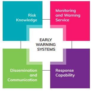
Regional/International Initiatives
•   Regional Cooperation Initiatives
     •  Sentinel-Asia -- Asia-Pacific Regional Space Agency Forum
     •  Satellite constellation for disaster monitoring -- Asia-Pacific Multilateral
        Cooperation on Space Technology and Applications

•   International Initiatives
     •   UN Platform for Space-based Information for Disaster Management
         and Emergency Response (UN SPIDER)
     •   ESCAP partners with UNOOSA to promote regional component of
         UN SPIDER
     •   International Charter on Space and Major Disasters
India‟s Supportive Role • Under the framework of Asia-Pacific Regional Space Agency Forum (APRSAF) initiative Sentinel Asia, ISRO supports the disaster management activities in Asia-Pacific region. • ISRO as the signatory of International Charter “Space and Major Disasters” supports various Authorized Users (AUs) of the Charter during major disasters. • ISRO also supports the Disaster Management activities of UNESCAP under regional co-operation.
India‟s Platform Initiatives
• ISRO disseminates relevant information from various sources (space
  technology, ground sensor technology, crowd source etc,.) in to an
  interactive geo-spatial domain through various geoportals under Disaster
  Management Support (DMS) Programme:
    • Bhuvan, National Database for Emergency Management
    • Meteorological & Oceanographic Satellite Data Archival Centre
       (MOSDAC) for the administrators to better understand the impact
       and for improved decision support.
India‟s Early Warning Preparedness & Response for Flood from Cyclones Preparedness With large coast line, India is susceptible for cyclones. So, understanding the impacts of cyclone, with respect to its earlier footprints, low lying areas, etc, can be achieved through satellite imagery. Using historical satellite data and Digital surface models, these inputs can be derived Early Warning System’s ISRO uses geo-stationary and low earth orbit satellites for providing experimental inputs on cyclogenesis, cyclone track, cyclone intensity. INSAT series of satellites with frequent imaging provide the cyclone parameters for near real time analysis using early warning system‟s Response Near real time information on inundation due to cyclones derived using optical and microwave SAR data is provided to the concerned departments for public announcement www.isro.gov.in/cyclones
Case Study I
Cyclone: „Yaas‟
Location: Odisha, India
Satellite Data:
• SENTINAL – 1A SAR
   (10/02/2021 & 29/05/2021)
• RADARSAT -2 SAR
   (27/05/2021 & 29/05/2021)

                      www.bhuvan.nrsc.gov.in
Case Study II
Cyclone: „Tauktae‟
Location: Gujarat, India
Satellite Data:
• SENTINAL – 1A SAR
(02/05/2021)
• RCM -1 SAR
(18/05/2021)
www.bhuvan.nrsc.gov.inIndia‟s Early Warning Preparedness & Response for Floods
Preparedness
Based on integration of historic satellite datasets acquired during major floods in different States, flood
hazard map layers were prepared for entire country
Early Warning System’s
Using hydrological modelling of satellite and ground based hydro-meteorological inputs and digital
elevation models, experimental spatial flood early warning systems are established for selected flood
prone rivers like Brahmaputra (Assam)
Response
Near real time information on flood inundation derived using optical and microwave SAR data is
provided to the concerned departments for public announcement
www.isro.gov.in/floodsCase Study III Flood Early Warning System (FLEWS) in Assam, India www.asdma.gov.in
Roadmap
            Preparedness & Response -    Improve Awareness on
                  Collaboration         Preparedness & Response
               Network Expansion            of Early Warning

Existing Policies &        Real-Time Data Sources    Incorporating Deep Learning
      Systems                Network Expansion         AI Early Warning Systems
References • https://www.un-spider.org/space-application/satellite-technology • https://www.un-spider.org/space-application/emergency-mechanisms • https://nidm.gov.in/easindia2014/err/pdf/themes_issue/technology/early_warnings.pdf • https://www.geospatialworld.net/blogs/space-technology-for-locust-early-warning- systems/ • https://www.unescap.org/sites/default/files/TechPaper-SoundPractices-in- SpaceApplications.pdf • https://www.mosdac.gov.in/ • https://bhuvan.nrsc.gov.in/home/index.php
You can also read