ASTRONAUT PHOTOGRAPHY OF THE EARTH: A LONG- TERM DATASET FOR EARTH SYSTEM RESEARCH
←
→
Page content transcription
If your browser does not render page correctly, please read the page content below
ASTRONAUT PHOTOGRAPHY OF THE EARTH: A LONG-
        TERM DATASET FOR EARTH SYSTEM RESEARCH,
              APPLICATIONS, AND EDUCATION
     Astronaut Photography of the Earth: A Long-Term Dataset for Earth System Research,
                                  Applications, and Education

                                            William L. Stefanov
                              International Space Station Program Science Office; and
                             Astromaterials Research and Exploration Science Division
                                   Exploration Integration and Science Directorate
                                            NASA Johnson Space Center
                                             Houston, Texas 77058 USA
                                             william.l.stefanov@nasa.gov

ISRSE 37, 09May2017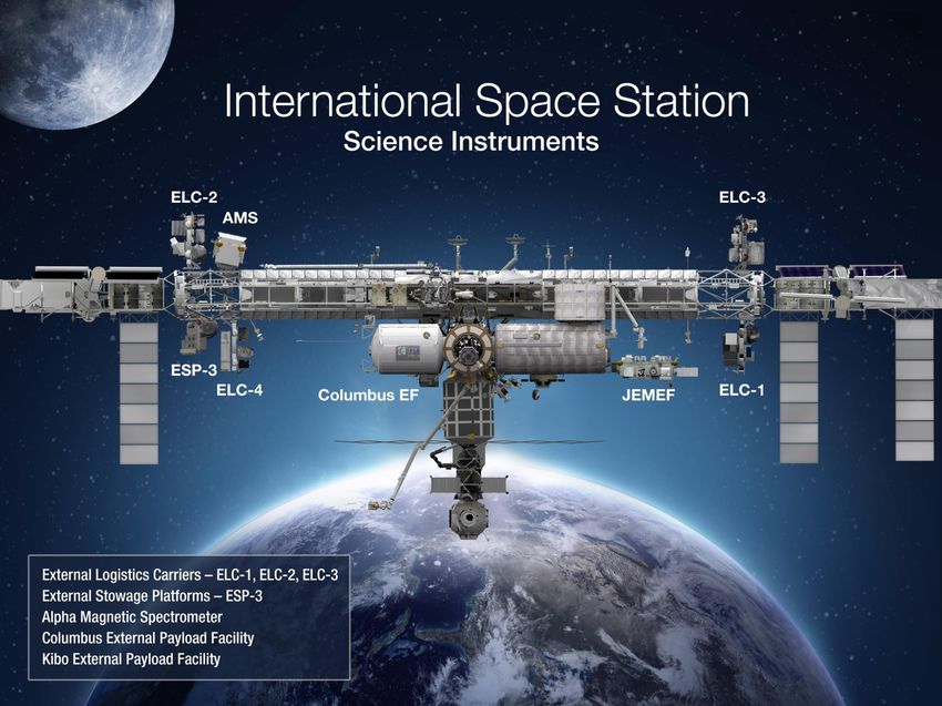
Source: http://www.mgmtdesign.com/MEDIA/PDF/MGMT_spacetravel.jpg

ISRSE 37, 09May2017
Polar orbit
                      • Sun-synchronous – designed for long
                        term repeatability of data

                      • Typically nadir viewing, crosses every
                        point on Earth ~ 12-14 days near local
                        solar noon/local midnight

                      • Landsat series collecting data since 1972

                      • Pointing capability, satellite constellations

                      Inclined Equatorial Orbit: ISS
                      • Sun-asynchronous – similar illumination
                      3-4 days every 90 days

                      • Nadir to highly oblique imagery possible
                      from hand-held cameras, WORF, external
                      sensors

                      • Provides opportunity to collect unique
                      datasets for scientific study, disaster
                      response

                      • Data is complementary to polar-orbiting
                      satellite data

ISRSE 37, 09May2017
Earth                                                   TSIS (2017 - 2022)
                                Information as of March 2017 – subject to change

                                                         LIS (2017 - 2019)
                                                         CLARREO (2020-2023)

    SAGE III (2017  )                                  EarthKAM (2001   )
    MUSES Platform (2017    )                          METEOR (2016-2018)
                                                       CEO (2000    ) CATS (2015-2019)
                                                                      NREP Platform (2017   )
                                          ASIM (2017-2020)            ECOSTRESS (2018-2020)
                                          HDEV (2014-2018)            GEDI LIDAR (2019-2021)
                                          GEROS (2019-2020)           OCO-3 (2018-2021)
                                                                      HISUI (2019-2022)
ISRSE 37, 09May2017                                                   HDTV (2017-2020)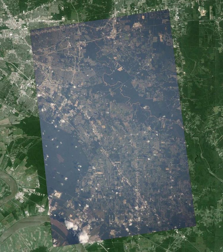
Sensor: Crew Earth Observations (CEO)
Location: internal, Station windows
Sponsor/Funding: ISSP; “task-listed” activity
Prime Mission: collection of Earth imagery in support of
disaster response, and dynamic events with other ISS
sensor systems. Also supports education/outreach and
focused short-term science objectives.
ISS Timeframe: 2000-2024
Principal Investigator: William L. Stefanov, JSC
Pointing capability: variable, dependent on window and lens
Geometric resolution: variable, depends on lens
< 3 m/pixel with 1000 mm lens to > 30 m/pixel with 110 mm
and shorter lenses
Spectral sensitivity: visible RGB, poorly constrained
Bandpasses (potential for NIR imagery using modified
camera)
Scene Size: variable, depends on lens, ISS altitude
Data take to availability time: ~ 24 hours for full resolution
data, may be possible to expedite; full georeferencing adds
24+ hrs depending on # of frames and difficulty
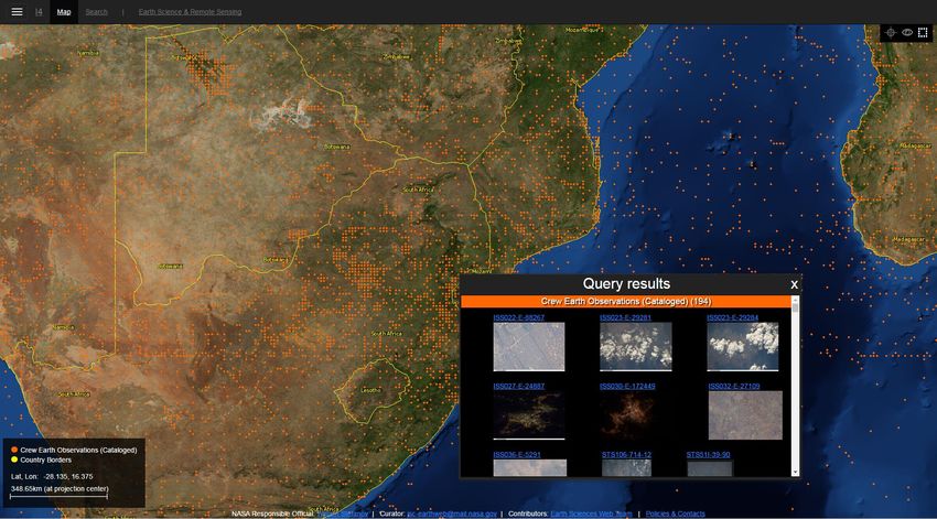
Data availability: Public; http://eol.jsc.nasa.gov
ISRSE 37, 09May2017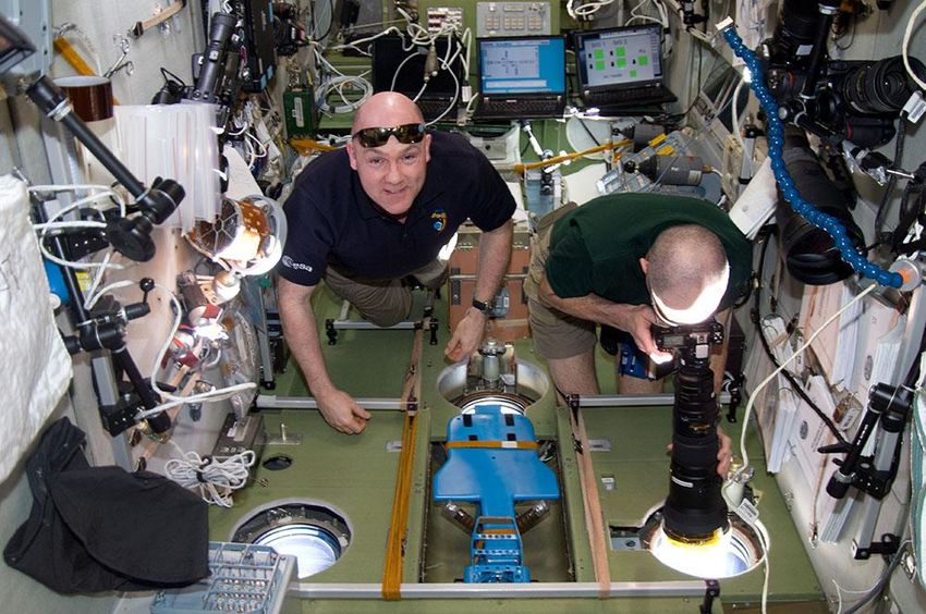
Description of crew training

Kyba, C.C.M, Garz, S., Kuechly, H., Sánchez de Miquel, A., Zamorano, J., Fischer, J., & Hölker, F.
(2015). High-resolution imagery of the Earth at night: New sources, opportunities and
challenges. Remote Sensing 7: 7-23.

Stefanov, W.L., and Evans, C.A. (2015) Data collection for disaster response from the
International Space Station. The International Archives of the Photogrammetry, Remote
Sensing, and Spatial Information Sciences 40, 7/W3, pp. 851-855.

Jehl, A., Farges, T., & Blanc, E. (2013). Color pictures of sprites from non-dedicated observations
on board the International Space Station. Journal of Geophysical Research, Space Physics 118:
1-8.

Jackson, C.R., & Alpers, W. (2010). The role of the critical angle in brightness reversals on
sunglint images of the sea surface. Journal of Geophysical Research, Oceans 115: C09019,
10.1029/2009JC006037
ISRSE 37, 09May2017

Still Imagery Downlink

 Still Camera                 ISS Laptop                                   TDRSS

      White Sands     MCC-H                  Johnson Space Center         Earth Science and
                                           Imagery Processing Facility   Remote Sensing Unit
                                               (NASA ID assigned)         (Image cataloging
                                                                         and georeferencing)

ISRSE 37, 09May2017
ISRSE 37, 09May2017

ISRSE 37, 09May2017
http://issearthserv.jsc.nasa.gov

ISRSE 37, 09May2017
GeoCam Space System – mid to late 2017
GeoSens Hardware
Pointing Calibration Targets mounted in cupola
Ideally, semi-permanent mounting to avoid recurring
setup time
During photography, ensure some calibration target is
occasionally in view of secondary camera
(Example: In view for at least 1 second every 5 minutes)
Given proper target placement, this may happen without
SECONDARY explicit astronaut attention
CAMERA Sensor package can use an audible tone to indicate
(left and rare cases when astronaut attention is needed
bottom- POINTING Trade-off: More targets vs. higher chance calibration
facing) CALIBRATION activity is needed
TARGET IN ISS
INTERIOR
LG Nexus 5
ISRSE 37, 09May2017Gateway to Astronaut Photography of Earth - https://eol.jsc.nasa.gov Earth Science and Remote Sensing Unit – https://esrs.jsc.nasa.gov
NASA Earth Observatory – https://earthobservatory.nasa.gov NASA Google Earth Layer
ISRSE 37, 09May2017International Disaster Charter Response (CEO)
IDC activation received
ISS orbit track No official target
from USGS, other
predictions (24 hr) No called out, but
information sources
reviewed for IDC target crew notified of
opportunities IDC event
Yes
Initial notification
IDC target time of orbit track
sent to NASA ISS
intersection and ground
sensor teams
position sent to crew; if data
acquired, placed in “IDC”
folder for immediate downlink Data delivered to
USGS for posting on
Targeting “nugget” Hazards Data
produced, and sent Distribution System
to NASA ISS sensor Downlinked data reviewed for and archiving on
teams QA/QC, and fully georeferenced GAPE; notification
using GeoRef software (manual sent to NASA Disaster
processing). Geocam system Coordinators Group
expected to semi- to fully
automate georeferencing
Since late April/early May 2012, ISS has received 198 IDC activations; data collected for
55 events and delivered to USGS (ISSAC, CEO, HICO, ISERV)
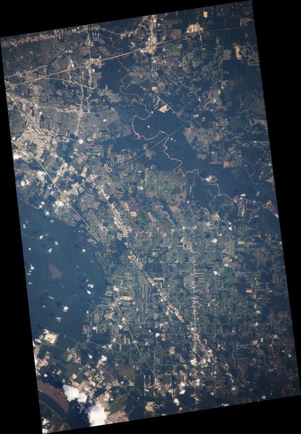
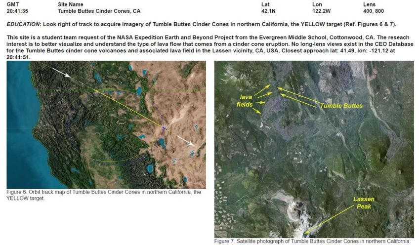
ISRSE 37, 09May2017• ISS USOS crew acquired imagery of flooding
area on Aug 16, 17, 23 in response to target
Baton Rouge, LA requests from JSC Crew Earth Observations
ops team (example of targeting information
lower right)
• Downlinked imagery reviewed and manually
georeferenced prior to delivery to USGS HDDS
Amite R. team
• Data potentially useful for validation of SAR and
flood extent model products
ISS048-E-65146
Acquired 08.23.16
500 mm lens
ISRSE 37, 09May2017Summary
o Astronaut photography online database includes images from 1961 to present (variable spatial and
temporal density): https://eol.jsc.nasa.gov
o Images are primarily visible RGB of low spectral quality but high spatial quality, amenable to
advanced analysis techniques such as Object Based Image Analysis
o
GEOBIA slide from Amy/Andi
Multiple image resolutions, look angles possible; day and night imaging capability
o Entire database searchable using a variety of keyword and graphical search interfaces; images
free for download and use with crediting back to NASA
o Both science and education Principal Investigator requests accepted (with acknowledgement of
caveats on crew imaging)
o New automated to semi-automated georeferencing system on schedule for delivery to ISS in late
2017
ISS Researcher’s Guide to Earth Observations -
https://www.nasa.gov/connect/ebooks/researchers_guide_earth_observations_detail.html
Reference Guide to the International Space Station -
https://www.nasa.gov/sites/default/files/atoms/files/np-2015-05-022-jsc-iss-guide-2015-update-111015-
508c.pdf
External Payloads Proposer’s Guide to the International Space Station -
https://explorers.larc.nasa.gov/HPSMEX/MO/pdf_files/ISS-External-Payload-Proposers-Guide.pdf
ISRSE 37, 09May2017Questions or Comments?
ISS042-E-24903: Sunrise over Indian Ocean
Acknowledgement to the NASA JSC ESRS team - P. Graff, J. Heydorn, M. Higgins, A. Hollier, A. Jagge, L. Mayer, S. Runco, M. Trenchard, L. Vanderbloemen, and M.J.
Wilkinson; mission operations teams; and special thanks to the astronauts whose Earth observation efforts created and sustain this valuable dataset.
ISRSE 37, 09May2017ISRSE 37, 09May2017
You can also read