Spatial Analytics Learning in GIS and Deep - Coordinates
←
→
Page content transcription
If your browser does not render page correctly, please read the page content below
RNI: DELENG/2005/15153                                                              No: DL(E)-01/5079/20-22
                 Publication: 15th of every month                    Licensed to post without pre-payment    U(E) 28/2020-22
                 Posting: 19th/20th of every month at NDPSO                                                           Rs.150
ISSN 0973-2136

                 Volume XVI, Issue 2, February 2020           THE MONTHLY MAGAZINE ON POSITIONING, NAVIGATION AND BEYOND

                                                     Spatial Analytics
                                                        and Deep
                                                      Learning in GIS

                            Technology trends-Opportunities and Challenges
RIEGL AIRBORNE LASER
 SCANNERS & SYSTEMS
 RIEGL WAVEFORM LIDAR TECHNOLOGY for TOPOGRAPHY
 CHOOSE THE SCANNER EXACTLY RIGHT FOR YOUR SPECIFIC SURVEYING MISSION!

                                              VISIT US AT
                                   March 23 - 25, 2020
                                   Washington, DC
                                   RIEGL booth 401

                                                                                                                                     58° FOV
                                                                                                                               forward/backward
                                                                                                                                 and nadir look
                                                                                                                                  2.66 MHz eff.
                                                                                                                                   pulse rate
                                                                                                        60° FOV
                                                                                                     1.33 MHz eff.
                                                                                                       pulse rate                    dual channel
                                                                            75° FOV                                                 turnkey system
                                                                                                                                   for high altitude,
                                                                         1.25 MHz eff.                                                large scale
                                                                           pulse rate                     for                          mapping
                                                                                                     customized
                                          75° FOV                                                      system
                                       1.25 MHz eff.                       especially               configurations
     75° FOV                             pulse rate                        for snowy
   1.5 MHz eff.                                                             and icy
    pulse rate                           for small                           terrain
     for UAVs                            planes or
    and small                           helicopters
     aircraft

     VUX-240                             VQ-480 II                         VQ-580 II                    VQ-780 II                     VQ-1560 II
  for surveying at low flight altitudes                      for surveying at mid flight altitudes           for surveying at high flight altitudes
      e.g. powerline, rail track and                        e.g. corridor mapping, city modeling,              e.g. ultra-wide area mapping of
           pipeline inspection                                            and forestry                              complex environments

Also explore RIEGL‘s proven LiDAR sensors
for UAVs and for BATHYMETRY     www.riegl.com
                       newsroom.riegl.international
       Scan this QR
       code to watch
       the     RIEGL
       videos     on
       our YouTube
       Channel.
                       RIEGL LMS GmbH, Austria              |   RIEGL USA Inc.   |   RIEGL Japan Ltd.   |   RIEGL China Ltd.   |    RIEGL Australia Pty Ltd.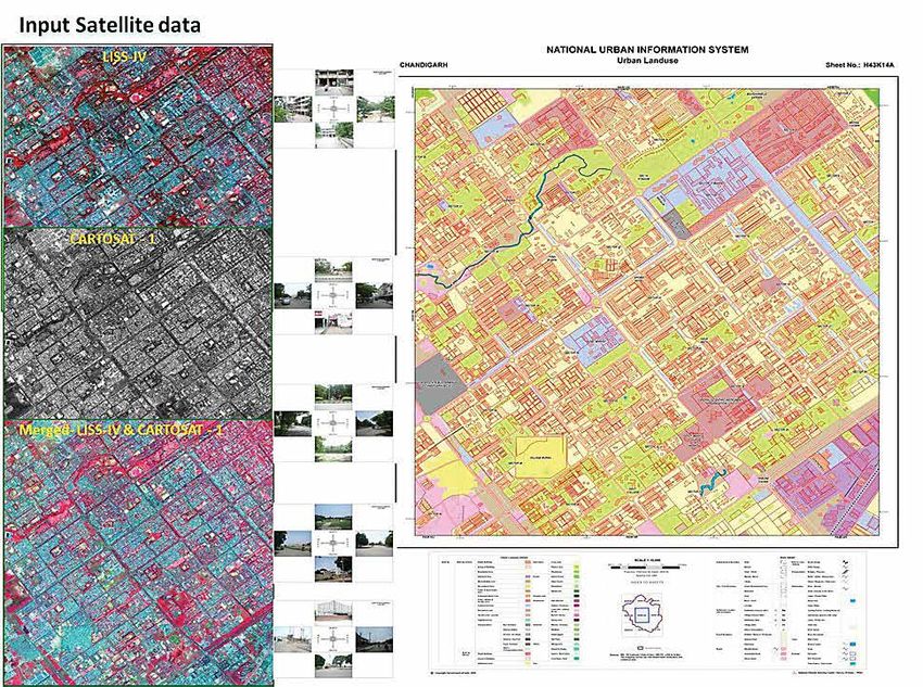
Coordinates February 2020 | 3

COLOPHON AND CONTENTS

 In this issue
 Coordinates Volume              16, Issue 2, February 2020

 Articles
 Geographic coverage expands as imaging technology matures Alexander Wiechert 6 Emerging PNT and
 GNSS Technology Trends: Creating Resilient, Wireless Connected Systems John Fischer 8 Challenges
 for 3D mapping Graham hunter 10 Application of GIS and remote sensing in urban planning Mohd. Monis
 Khan 12 Identifying GNSS market in Indonesia before and the future Heri Andreas and Sandy Noveriansyah 14
 Spatial Analytics and Deep Learning in GIS Dr K Kasturirangan 29

 Columns
 My Coordinates Editorial 5 Old Coordinates 20 Conference Workshop on Advanced Spatial Analytics and Deep Learning
 for Geospatial Applications His Coordinates 33 Mukund Kadursrinivas Rao 35 News GIS 37 LBS & AI 38 GNSS 40 Imaging 42

 UAV 43 Industry 44 Mark your calendar March 2020 to December 2020 46
 This issue has been made possible by the support and good wishes of the following individuals and companies
 Alexander Wiechert, Graham hunter, K Kasturirangan, Heri Andreas, John Fischer, Mohd. Monis Khan, Mukund
 Kadursrinivas Rao and Sandy Noveriansyah; Javad, Labsat, Vexcel, Riegl, SBG System, and many others

 Mailing Address                                    Coordinates is an initiative of CMPL that aims to broaden the        Printed and published by Sanjay Malaviya on behalf of
 A 002, Mansara Apartments                          scope of positioning, navigation and related technologies.           Coordinates Media Pvt Ltd
 C 9, Vasundhara Enclave                            CMPL does not neccesarily subscribe to the views expressed           Published at A 002 Mansara Apartments, Vasundhara
 Delhi 110 096, India.                              by the authors in this magazine and may not be held liable for       Enclave, Delhi 110096, India.
 Phones +91 11 42153861, 98102 33422, 98107 24567   any losses caused directly or indirectly due to the information      Printed at Thomson Press (India) Ltd, Mathura Road,
                                                    provided herein. © CMPL, 2020. Reprinting with permission is         Faridabad, India
 Email                                              encouraged; contact the editor for details.
 [information] talktous@mycoordinates.org                                                                                Editor Bal Krishna
 [editorial] bal@mycoordinates.org                  Annual subscription (12 issues)                                      Owner Coordinates Media Pvt Ltd (CMPL)
 [advertising] sam@mycoordinates.org                [India] Rs.1,800 [Overseas] US$100
 [subscriptions] iwant@mycoordinates.org
 Web www.mycoordinates.org                                                                                            This issue of Coordinates is of 48 pages, including cover.

4 | Coordinates February 2020
MYCOORDINATES

                                                   Quarantined
                                                   As the official figure of deaths

                                                   Due to novel corona virus (Covid-19) surges to over 1,100,

                                                   The situation is frightening.

                                                   When thousands of the victims are being quarantined and treated,

                                                   The challenge is to trace the many, who might have been infected,

                                                   And how to curtail its further spread.

                                                   The World Health Organization recognizes the threat

                                                   As grave and global.

                                                   The world grapples to figure out ways to deal with the situation

                                                   Which is not only medically challenging

                                                   But also emotionally and socially traumatic.

                                                   The likely devastating fallouts on economy

                                                   Are yet to be assessed.

                                                   The virus is a threat to the humankind.

                                                   It also has put on test

                                                   The humanity per se.

                                                                                                               Bal Krishna, Editor
                                                                                                           bal@mycoordinates.org

  ADVISORS Naser El-Sheimy PEng, CRC Professor, Department of Geomatics Engineering, The University of Calgary Canada, George
  Cho Professor in GIS and the Law, University of Canberra, Australia, Professor Abbas Rajabifard Director, Centre for SDI and Land
  Administration, University of Melbourne, Australia, Luiz Paulo Souto Fortes PhD Associate Professor, University of State of Rio Janeiro
  (UERJ), Brazil, John Hannah Professor, School of Surveying, University of Otago, New Zealand

                                                                                                                Coordinates February 2020 | 5
PERSPECTIVE

 Geographic Coverage
 Expands as Imaging
 Technology Matures
 Vexcel Imaging will continue to develop advanced
 hardware and software for the benefit of its commercial
 customers and for VDP with a focus on optimizing
 efficiency and quality.
 By Alexander Wiechert, Vexcel Imaging GmbH

 R  emote sensing relies on hardware, software and
    workflow processes to deliver consistent and useful
 imaging products for a broad range of applications. When
                                                                focusing on more subtle evolutionary hardware changes.
                                                                We are making modifications that increase efficiency and
                                                                enable improved quality. For example, with faster frame
 the industry was in its infancy, a great deal of attention     rates and new camera electronics, airplanes can fly at
 was focused on improving the hardware to collect a much        higher speeds and collect data with a greater forward
 higher quality of data. Now we must fine-tune the software     overlap, which leads to better image quality and more
 and workflow processes to fully leverage the tremendous        efficiency.
 amount of data that is being generated. After a hectic
 period marked by significant advances in collection and        To continue delivering improvements to our customers,
 processing capabilities, we have reached a more stable         Vexcel Imaging is developing a completely new camera
 point with development cycles becoming longer and              design. We are changing everything — lenses, sensors,
 incremental benefits to the customer.                          electronics, storage, and housing. This 4th generation
                                                                UltraCam camera is based on the latest CMOS sensors
 Hardware First                                                 instead of CCD, which boosts efficiency to the next level.
 Hardware became the first “battleground” as industry           The newest CMOS technology, for example, supports
 leaders continued to experiment with different approaches.     an increased pixel count in the imagery and provides
 Eventually imaging technology made the revolutionary           radiometric advantages and better image dynamics without
 leap from analog to digital, which resulted in significant     the downsides present in previous generations of CMOS.
 performance improvements and created many new
 opportunities.                                                 The entire suite of UltraCam cameras will benefit from
                                                                the new design, with the expected efficiency gain to be
 Now that a digital format is accepted as the most effective    between 15‒40%, depending on the camera model. The
 technology for mapping, the aerial imaging industry is         updated UltraCam Osprey will be released first, in spring
                                                                             2020, with a wider nadir footprint and an
                                                                             almost doubled oblique collection capability.
                                                                             Next in line for release is the UltraCam Condor,
                                                                             scheduled in 2021, which will also offer a
                                                                             significantly larger footprint and faster frame
                                                                             rate. A new version of the UltraCam Eagle will
                                                                             follow at a later stage.

                                                                             Handling the Data
                                                                             Since imaging hardware has achieved such
                                                                             high performance levels, next the industry
                                                                             has to focus on software development and
                                                                             workflow processing. The volume of data
                                                                             collected by advanced aerial and satellite
 UltraCam Osprey Mark 3 Premium. The next generation UltraCam                imaging resources has increased exponentially,
 Osprey model will be released later this year.                              so software products must handle larger

6 | Coordinates February 2020
data streams. Workflow processes are being streamlined           annual coverage of the entire US and several European
to handle the increased volume of data. As a result, the         countries at 20 cm GSD, with major metro areas collected
industry continues innovating by adding automation and           at a higher resolution of 7.5 cm GSD. More recently survey-
updated workflows to keep pace with the hardware and to          grade (metric/calibrated) oblique data to facilitate 3D
meet the demand for faster turnaround of end products            modeling of buildings is also being collected.
and analysis.
                                                                 The second category is “gray sky” collections, which take
Vexcel Imaging is committed to investing in further              place in disaster areas, immediately after floods, fires,
development of UltraMap, our photogrammetric post-               hurricanes, earthquakes, etc. Vexcel’s highly automated
processing software that provides highly automated               processing capability makes images accessible online within
processing capabilities. We just launched Version 4.5 in         24 hours after data collection to all government agencies
November 2019, featuring real Oblique AT, and 5.0 is on the      and other emergency personnel. This access is provided
horizon, which will add a rich feature set to further improve    through GIC/NICB and has substantially improved the
efficiency and 3D capabilities. Vexcel has learned many          situational awareness of organizations trying to deliver
lessons while processing our own huge datasets and that          services in devastated areas.
experience goes into UltraMap
to benefit our commercial
customers.

International Flying
Programs
Another factor driving
improvements in hardware,
software and workflows is the
creation of large flying programs
that focus on high-resolution
mapping of entire countries
on a regular revisit schedule.
Several flying programs started
by global companies are
applying the lessons learned
from decades of hardware
manufacturing and software
development to improve their
own collection and processing
efforts and make up-to-date
imagery available to meet the
growing demand for high-
resolution maps.                             Philadelphia, PA, USA. Blue sky imagery captured for the Vexcel Data Program.

The Vexcel Data Program (VDP) is a cloud-based imagery           Demand for imagery is increasing around the world.
service, founded in 2018 with the insurance industry as an       The geographic priorities of Vexcel’s global partners are
anchor customer. Vexcel’s exclusive partner, the Geospatial      influencing the selection of overseas targets. In 2020, with
Intelligence Center (GIC), was initiated by the National         the UltraCam Condor collecting nadir imagery, geographic
Insurance Crime Bureau (NICB) that represents over 1,000         coverage will grow in Europe and potentially areas in the
insurers in the US. The consortium of insurers shares the        Asia Pacific region. The UltraCam Osprey is also collecting
GIC program costs in return for access to current aerial         high resolution urban oblique imagery of major areas in the
imagery before and after natural disasters. Insurers benefit     United States, and the program is expanding to Australia,
from the expedited process where agents can review               New Zealand and other Asian locations.
imagery to assess damage instead of traveling to the site
and deliver value to their customers with more accurate          Large flying programs are the way of the future as they
claim evaluations and faster payments.                           allow up-to-date imagery of entire countries to be
                                                                 available at lower cost. Vexcel Imaging will continue to
VDP has a two-pronged approach to data collection. “Blue         develop advanced hardware and software for the benefit
sky” refers to the scheduled collection of priority areas to     of its commercial customers and for VDP with a focus on
complete large-area datasets. Initially the plan called for      optimizing efficiency and quality.

                                                                                                        Coordinates February 2020 | 7
TECHNOLOGY TRENDS

 Emerging PNT and GNSS
 technology trends
 Creating resilient, wireless connected systems

                      John Fischer
                      Leading industry authority
                      in PNT and GNSS
                                                   A     s Coordinates readers, you appreciate
                                                         the value of knowing where you are
                                                   and what time it is, along with the best
                                                                                                 through along the way. On a personal level,
                                                                                                 getting the wrong PNT data could mean that
                                                                                                 you run out of gas, get lost or wind up in a
                      technologies, and serves     route to your destination. Whether you’re     dangerous area. For critical infrastructure
                      as the VP of Advanced        on your way to an important business          and defense programs, it can bring far worse
                      R&D for Orolia, the world    meeting at an office you’ve never visited,    consequences. Add to that the fact that rogue
                      leader in Resilient PNT      or you need to find the safest route          actors are getting more sophisticated in
                                                   through dangerous environments, you           spoofing and jamming, and the risk of PNT
                                                   need reliable, continuous Positioning,        data disruption and loss grow exponentially.
                                                   Timing and Navigation (PNT) data.
                                                                                                 Next to PNT data, one of the most
                                                   No matter how sophisticated our               important tools for the latest technology
                                                   technology environment becomes and            innovations is access to GPS/GNSS
                                                   how much further we evolve into a more        signals. After all, most PNT data is
                                                   digital and mobile world, we should           delivered through these signals and we use
                                                   be mindful that for many of our most          GNSS signals for so many critical needs.
                                                   essential tasks, it all comes down to the     We rely on having a signal wherever we
                                                   availability of essential resources like      go, and we aren’t particularly opinionated
                                                   PNT data and GPS/GNSS signals. When           about it as long as it works and we can get
                                                   we look at emerging technology trends,        things done. Like turning on a light switch,
                                                   these common denominators are having          we hardly ever think about it but we expect
                                                   a greater impact on industry’s ability        it to be immediately available 24/7.
                                                   to deliver reliable new technologies
                                                   that are immune to emerging threats.
                                                                                                 Why will emerging
                                                   Most of us use PNT data every day without     technology continue to
                                                   even thinking about it. We check our route    rely on PNT and GNSS?
                                                   options for morning traffic and, on hectic
                                                   days, we might need to find the nearest       Wireless connections are becoming
                                                   gas station or a coffee shop with a drive-    required as the minimum starting point for
                                                                                                 any new technology. If we no longer need
                                                                                                 wired connections because our wireless
   As PNT industry leaders, we need to establish,                                                connections are seamless, new technology
                                                                                                 can transcend geographic, environmental
   continuously improve, and adapt our technology with                                           and other barrier limits that exist today.

   features that guarantee PNT data integrity in every                                           Data speed and capacity are also essential.
                                                                                                 Transmission rates must continue to get
   environment. By the way, it’s not just PNT data that we                                       faster to keep up with our requirements for
                                                                                                 instant results. Newer technologies often
   need to protect. We also need to ensure continuous                                            involve much larger file and data packet
                                                                                                 sizes, so data capacity also has to keep
   access to resilient GNSS signals to transmit the data                                         expanding in line with increasing demand.

   that PNT-reliant systems need in order to operate                                             What will these next-gen technology

8 | Coordinates February 2020
features do for us? With failsafe wireless       It’s also important to realize that a single upgrade
connections, lightning fast data speeds
and extensive data capacity, we can              won’t be enough. Continuous system testing
enable connected systems, wireless
networks and hive technology to converge         through simulation, developing new solutions to
our resources into a collective “brain”
and manage everything at once. When              defeat new threats, and Interference Detection and
we no longer have to build tethered
data connections, we can achieve                 Mitigation (IDM) technologies are needed to close
exponentially superior automatic systems
that are not only efficient, but operate         the loop and maintain system integrity over time
harmoniously with infinite inputs.
                                                Looking ahead                                 been compromised. Today’s adversaries
                                                                                              are developing more sophisticated
What do these technology                        Weighing the risks and benefits of            GNSS jamming and spoofing methods,
trends mean for the                             emerging technology trends, it’s better       and they can be so subtle that you’d
PNT industry?                                   to embrace new technologies and the           never know they were there.
                                                benefits they offer, rather than clinging
As PNT industry leaders, we need to             to archaic ideas. New technologies are        While resilient technologies and testing
establish, continuously improve, and adapt      being developed faster than ever, and as      through simulation can provide confidence
our technology with features that guarantee     PNT leaders we need to offer access to        that your system will overcome certain
PNT data integrity in every environment.        these features right away, not years from     known threats, there are always new
By the way, it’s not just PNT data that we      now. Bolt-on and retrofit PNT and GNSS        threats that we can’t test for today. As a
need to protect. We also need to ensure         solutions are available now that can not      result, alerting systems that can detect
continuous access to resilient GNSS             only future-proof existing systems, but       and inform you when you’re under attack
signals to transmit the data that PNT-reliant   also protect them from the latest threats.    are fundamental for critical systems.
systems need in order to operate. Our
contributions to emerging technologies can      With new digital technology, we can           The PNT kit of the future will need to
provide the assurance of PNT data integrity     solve problems and increase efficiency        ensure continuous, reliable PNT data and
and GNSS signal access as building blocks       in ways that would take decades or more       access to GNSS signals, while protecting
for tomorrow’s wireless connected systems.      for humans to do on their own. At the         against emerging threats. It also needs to
                                                same time, we shouldn’t rely too much         provide high data transfer capacity and hub
We also need to respond to the growing          on machines to make our decisions.            technology to integrate data from multiple
demand for multiple data inputs by              It’s important to maintain human in the       remote sources. These needs are immediate,
providing data hub and integration              loop technology so that we can make a         and bolt-on solutions can provide the
technologies to facilitate connected            human decision based on better facts.         fastest route to a system upgrade.
systems. By converging data points from
multiple sources, we can enable higher          The need for wireless, global, continuous     It’s also important to realize that a single
order data analysis and processing for          and unimpeded data and communications         upgrade won’t be enough. Continuous
more intelligent, informed digital decision-    signals will continue to grow. For PNT        system testing through simulation,
making based on countless data points.          reliant systems, the data and signals are     developing new solutions to defeat
                                                essential, and our role as industry experts   new threats, and Interference Detection
                                                to protect them is more critical than ever.   and Mitigation (IDM) technologies
 Critical systems require                                                                     are needed to close the loop and
                                                Critical systems require extensive            maintain system integrity over time.
 extensive testing, that                        testing, that will increasingly require
                                                sophisticated simulation to assess real       With these emerging technologies to
 will increasingly require                      world performance for missions that           look forward to, it’s an exciting time
                                                cannot afford to fail. For consumer           for our industry, global businesses and
 sophisticated simulation                       technologies, simulation helps ensure         consumers. With Resilient PNT and GNSS
                                                that we can rely on our personal devices      systems, along with better data integration
 to assess real world                           and trust them to perform as promised.        and processing, we can trust this new
                                                                                              technology to tell us the truth and keep
 performance for missions                       While testing, simulation and Resilient       us safe, while enabling us to reach for the
                                                PNT technologies can keep us online,          stars and understand our world in ways that
 that cannot afford to fail.                    we also need to know when our data has        we’ve never been able to do before.

                                                                                                                Coordinates February 2020 | 9
TECHNOLOGY TRENDS

 Challenges for 3D mapping
 From controlling project timeframes and cost consumption, to sustainability
 and overcrowding, SLAM (Simultaneous Localization And Mapping) technology
 has become a powerhouse for progression in developing economies

                     Graham Hunter
                     GEOSLAM Founder   A     lthough awareness of SLAM
                                             (Simultaneous Localization And
                                       Mapping) technology is at a very nascent
                                                                                       enormous infrastructure development
                                                                                       works in order to meet the demand of the
                                                                                       rising population. The scale of the country
                                       state in some countries such as India,          means it also has the second largest railway
                                       mapping technology itself has been              network in the world, and the government
                                       particularly influential in the decision-       is working to electrify the entire network
                                       making process and management of various        in order to bring the benefits of the latest
                                       built environments. From controlling            technological innovations to the economy.
                                       project timeframes and cost consumption,
                                       to sustainability and overcrowding, this        Implementing these changes however
                                       technology has become a powerhouse for          is a challenge in itself, because of the
                                       progression in developing economies.            country’s diverse and challenging physical
                                                                                       geography, which spans 3,287km2
                                                                                       across a broad range of terrains. Much
                                       Mapping a challenging                           of the country’s existing infrastructure
                                       landscape                                       including bridges and roads, which
                                                                                       were built during the nineteenth
                                       Among other factors, the biggest hurdle         century, are no longer fit for purpose.
                                       for leaders of developing economies is
                                       to complete projects within promised
                                       deadlines and budgets. While this is a          Overcoming skills shortages
                                       frequent obstacle for most countries around
                                       the world, the implications of under-           India Today recently reported that over
                                       budgeting and forecasting an unachievable       80 per cent of Indian engineers are
                                       timeline in a developing economy could be       unemployable, citing a lack of new-
                                       significantly detrimental, wasting materials,   age technology skills and an absence of
                                       labour and, in some cases, bringing projects    fundamental training. It also stated that
                                       to a complete halt. As India’s government       only three per cent of engineers have
                                       seeks to improve its population’s standard      skills and knowledge in areas that are
                                       of living, the country is undergoing            booming, including AI, machine learning,
                                                                                       data science and mobile development.

   the biggest hurdle for leaders of developing economies                              Combatting these skills shortages,
                                                                                       GeoSLAM’s method of data collection
   is to complete projects within promised deadlines                                   can be performed by anyone, from
                                                                                       inexperienced junior staff to senior
   and budgets. While this is a frequent obstacle for                                  construction workers through its easy-
                                                                                       to-use mapping solution. Individuals
   most countries around the world, the implications                                   do not require any additional skills
                                                                                       to operate the devices, enabling the
   of under-budgeting and forecasting an unachievable                                  project to continue with no hold ups.

   timeline in a developing economy could be significantly
                                                                                       Pushing a ‘mega city’
   detrimental, wasting materials, labour and, in some                                 to its limits
   cases, bringing projects to a complete halt                                         The overcrowded city of Mumbai for

10 | Coordinates February 2020
example, which houses roughly 22 million what we’re doing is democratising to the world the
people, is the fourth most populated city
in the world, coined India’s largest ‘mega ability to have 3D information at your fingertips.
city’. Pushed to its limits through poor
city planning, its residents are suffering This data is no longer in the domain of surveyors or
at cramped railway stations, office
buildings and roadsides. The situation companies selling expensive high-end equipment
became so bad, that in 2013 the state
minister for housing backed calls for - it’s there for anyone to access. The real challenge
another new city to be constructed 50
miles away in Uran, to spread the load. though, is how to interpret and manage that data
Several versatile devices capable of managed and maintained carefully in citizens across the world would experience
being used as a handheld device as well order to properly cater to the masses. the benefits that come with these systems.
as being mounted onto a vehicle and an
UAV, will enable city planners to access a Costa Rica, a country, which has recently
clear, aerial view of the ground beneath, witnessed steady economic growth, has Democratising 3D information
providing an indication of severely also turned to the latest technology to
overcrowded areas of a city or locations assist with rising population rates and I would predict that we are going to
of interest for future infrastructure, in the increase in deforestation. Monitoring see more rapid data capture. We live
order to avoid future mismanagement. systems have been used by city planners in a ‘3D plus’ society that historically
and non-governmental organisations has proven hard to capture.
To tackle the housing crisis, GeoSLAM to map areas of the country’s built
teams visited India in 2016 to environment to locate where people have For us, what we’re doing is
help support the redevelopment of built illegal properties, and as a way to democratising to the world the ability
slum housing, as part of the Prime monitor sustainable forest management. to have 3D information at your
Minister Housing Scheme (Pradhan fingertips. This data is no longer in
Mantri Aawas Yojna PMAY). This technology will enable governments the domain of surveyors or companies
and city planners to enforce planning selling expensive high-end equipment
The scheme, which aimed to build 20 models into cities, ensuring dangerous - it’s there for anyone to access.
million low-cost homes by 2022, involved situations such as these don’t occur The real challenge though, is how
demolishing collapsing slums and again. This might include mapping to interpret and manage that data.
setting out plans to create new homes, areas for potential development of
which were better fit for purpose. businesses and apartments; reducing the With the demand for capturing data on
rate of deforestation and organising new the rise, more devices are entering the
networks for a streamlined transport market with a focus on accessibility
Managing the built system and installing fibre-optic cables and ease-of-use. As more data is
environment so that everyone is fully connected. created, the need for managing that
information and providing useful insights
Unlike the UK, bridges in India are quicker, will be on the increase.
not inspected every year and so many UAVs flying high
problems with infrastructure go unnoticed. Data is also being shared more
Mounted onto an UAV or simple backpack From delivering life-saving medicine, frequently too, from construction sites
solution, the Horizon for example can map to mapping and monitoring sites for to head offices across the world, putting
the current state, movement and predicted refugee camps, UAVs have huge potential more emphasis on the importance of
decline of a structure, as well as rapidly for helping developing economies. managing results so that that data can
demonstrating where improvements be interpreted in a meaningful way.
are needed to ensure stability. Although their benefits are proven, their
reputation for causing disruption in the air New workflow software’s are being
We’re also working with more other precedes them. However in my opinion, developed that will be able to manage the
Asian countries like Singapore and the effect of drone-captured data and a vast amounts of data that will be generated,
Malaysia, as they drive to become ‘smart’, drone’s ability to deliver drugs to remote then to automate the processing and
and, like India, tackle the increasing or hard-to-access areas, far outweigh communication of that data. It will also
number of people moving to ‘mega any concerns that people may have. If be a platform for data to be backed up and
cities’ in search of a better way of life. restrictions on drone technology were stored in the right place, so that it can be
Mega cities need to be mapped out, relaxed, then perhaps more countries and accessed from anywhere in the world.
Coordinates February 2020 | 11URBAN PLANNING
Application of GIS and remote
sensing in urban planning
Initiatives of Ministry of Housing and Urban Affairs, Government of India
Mohd.Monis Khan
Town & Country Planner,
Head, Urban and
T he Ministry of Housing and Urban
Affairs (MoHUA) is engaged in the
development and promotion of State-of-
Central and State level so as to enable
updating of the maps in a revision cycle.
Regional Information Art Technologies such as Geographic In the first phase, 25 towns from six States
System (URIS) Division, Informat ion System and Remote Sensing, were selected on priority basis for coverage
Town & Country Planning Aerial Photography etc. since 1990’s. The under this scheme and in the Second phase
Organisation, Ministry Ministry has handled several projects and 28 towns from 19 State were taken. The
of Housing and Urban schemes such as Urban Mapping Scheme, work of aerial photography and mapping
Affairs Govt. of India, National Urban Information System, Sub- was assigned to NRSC for all 53 towns.
New Delhi, India Scheme of formulation of GIS based All the maps generated under the Scheme
Master Plan for 500 AMRUT cities. have been sent to respective State Town
Planning Departments for their use.
Urban Mapping Scheme
National Urban
The Ministry has launched a pilot scheme Information System
for preparing large-scale urban maps
using aerial photography for 53 towns The Ministry has launched National Urban
in order to meet the requirement of base Information System (NUIS) Scheme in
maps for towns and cities, was taken up March, 2006 to develop GIS databases
during the Eighth Five Year Plan. The for 152 towns/ cities in two scales i.e.,
budget allocation for the Scheme was 1:10,000 and 1:2000. Apart from spatial
20.39 Crores. The project envisaged data, the Scheme had other components i.e.
development of technical capabilities National Urban Data Bank and Indicators
of the town planning organisations at (NUDBI), Capacity Building, HW/SW
and Application Development. The total
outlay of the scheme was Rs. 66.28 Crores
of which 75% was borne by the Central
Govt. and the remaining 25% by the State.
The work of spatial data was undertaken
by the Survey of India, Dehradun. The
spatial and attribute databases thus
generated were used for preparation
of Master/ Development plans, town
planning schemes etc. serves as decision
support for e-governance purposes.
The scheme is has been successfully
completed in 31st March, 2018.
Sub-Scheme on formulation
of GIS-based Master
Plans for AMRUT Cities
Line Map and digital map generated under Urban Mapping Scheme Formulation of GIS-based Master
12 | Coordinates February 2020Maps generated under NUIS Scheme
Plans for 500 AMRUT Cities is one
of the important reforms under the
AMRUT Mission. It has three major
components i.e. Geo-database Creation,
GIS based Master Plan Formulation and
Capacity Building. As on date 34.
States/UT with 456 towns are covered
under the Sub-Scheme. The total
budget allocation for the Sub-Scheme
is Rs.515 Crores and sum of Rs. 97.31
Crores has been released to States.
An MoU has been signed between
National Remote Sensing Centre (NRSC), Draft GIS based Master Plan formulated under AMRUT GIS Sub Scheme
Department of Space and Ministry
for Geo-database creation, but State State Resources/ consultants. NRSC has Under the Sub-Scheme, as on date 226
Governments can opt NRSC or private established well equipped GIS Lab facility cities have prepared the Draft base Maps,
consultancies for Geo-database creation with 150 systems at their Jeedimetla 24 cities have prepared and submitted
Campus in Hyderabad and about 300 the Draft Master Plans and 1297 officials
Accordingly, 21 States/UTs (242 towns/ man hour works is being done daily to from various State Governments have
Cities) are with NRSC and 13 States/ accomplish the task of Geo-database been trained in 43 training programmes
UTs are creating Geo-database with creation under the Sub-Scheme. under Capacity Building.
Coordinates February 2020 | 13GNSS
Identifying GNSS market in
Indonesia before and the future
This paper will highlight the GNSS market in Indonesia before and the future.
We found that within ten to fifteen years the GNSS market in Indonesia will
be the biggest around South East Asia and probably in Asia Pacific
Heri Andreas
Geodesy Research
Division, Faculty of Earth
G lobal Navigation Satellite System
(GNSS) is one of the best finding of
the twenty century world technologies.
Indonesia will be the biggest around South
East Asia and probably in Asia Pacific.
Science and Technology, It is satellite base positioning and timing
Institute of Technology system. A millimeter accuracy of 4D Introduction
Bandung, Indonesia positions can be provided by this GNSS
system, allowed us to measure the The revolution in world scale positioning
geodynamic with millimeter per year signal has begun as the satellite technology
Sandy Noveriansyah only, measure small deformation and even invented in the beginning of year 70.
Universitas Komputer the change of pole of earth rotation. Not Global Navigation Satellite System
(UNIKOM), Indonesia to mention the GNSS for navigation and (GNSS) has been played as remarkable
transportation system, it helps a lot in such tool for positioning and mapping with high
traffic management, tracking, controlling, accuracy can be achieved in the easiest
etc. GNSS market
has contributed huge
amount of dollars in
world’s economy.
Japan and America
are two country
of among others
for biggest GNSS
market so far. As for
Indonesia, it is only
part of 4% of Asia
market in the early
2000. With such
similar characteristic
between Indonesia Fig. 1. Illustration of positioning using GNSS technology.
and Japan, especially
relating to fast
growing nation and
the ring of fire, in
this case market of
GNSS in the future
can be promising
in Indonesia. This
paper will highlight
the GNSS market
in Indonesia before
and the future. We
found that within
ten to fifteen years Fig.2. Illustration of multiuse of GNSS (GPS
the GNSS market in and GLONASS) in variety of fields.
14 | Coordinates February 2020way (Seeber [1], Abidin [2-3], Leick [4], Hofmann et. al. [5]). market has contributed huge amount of dollars in world’s
In everywhere and in anytime worldwide when signals from the economy. Japan and America are two country of among others
satellites received by the receivers, in these cases the position in for biggest GNSS market so far. As for Indonesia, it is only part of
3D or even 4D can be determined precisely (figure 1) and even 4% of Asia market in the early 2000 (DOC [6]). With such similar
with precision in the order of millimeter. Not to mention, the characteristic between Indonesia and Japan, especially relating
position can be also precisely determined “real-time” in the order to fast growing nation and the ring of fire, in this case market of
of few centimeter by Real Time Kinematik (RTK) Method. The GNSS in the future can be promising in Indonesia. This paper will
GNSS become a revolution in positioning on the 20th century. highlight the GNSS market in Indonesia before and the future.
Global Positioning System (GPS) and Globalnaya navigatsionnaya
sputnikovaya sistema (GLONASS) are GNSS product by US World GNSS market
and Russia. For more than two decade they give all kind of
services on positioning and timing. In the case of positioning With such tremendous contribution to the world in context
they allowed us to measure the geodynamic with millimeter per of application of positioning and timing (e.g. Navigation,
year signal only, measure small deformation and even the change transportation, survey and mapping etc. as mentioned) the GNSS
of pole of earth rotation. Not to mentioned their positioning market has given huge amount of dollar in world’s economy
services for survey and mapping and geodetic engineering. like previously mentioned. The value of the world GNSS
In the context of navigation, they helps a lot in such traffic technology business in 2002 reached $ 9 billion with an annual
management, tracking, controlling, etc. Figure 2 shows many increase of around $ 1 billion. This means that currently the
multiuse of GNSS GPS GLONASS in variety of fields. value of the GNSS technology business is estimated linearly in
more than $24 billion. On the other hand an estimation of $ 96
In the recent years, the GNSS is expanding when the BEIDOU billion is given by GNSS market for present years (GPS World
or COMPAS has been launched by the China, the GALIEO by [7]). Global GNSS GPS receiver market by geography shows
European Union, QZSS (Quasi Zenith Satellite System) by the America and Asia Pacific (but mostly Japan) are the biggest
Japan, etc. So, today it is not only GPS and GLONASS who market until today. It is 31.02% and 42.11%. Meanwhile 26.87%
existed and give services in positioning and timing, we have more. credit for Europe and Middle East (Businesswire.com [8]).
The additional satellite system is theoretically adding the value
to others GNSS System since more satellite can be observed. In 2016, the GPS receiver market in Asia Pacific (APAC) was
Also with combination of geostationary and original prograde valued at $1.52 billion. In the same year the GPS receiver market
satellite of 12 hour period, the positioning will be more robust. in Europe and Middle East (EMEA) is growing at a CAGR of
10.25%. The GPS Receiver market in Americas is expected
With such remarkable services in positioning and timing, GNSS to reach $2.26 billion by 2021 (Businesswire.com [8]).
Fig.3. Map of world transaction on GNSS GPS Receiver by 2016. APAC own 42.11%, EMEA own 26.87% and AMERICAS own 31.02%.
The future prediction conclude APAC will be the biggest market in the world [8]
Coordinates February 2020 | 15Do not forget that we just talking about GPS receivers only. As etc. If we included this segment into economic value,
explained above, In the recent years, the GNSS is expanding in this case more billions dollar should be added.
when the BEIDOU or COMPAS has been launched by the China,
the GALIEO by European Union, QZSS (Quasi Zenith Satellite China market and economic value of GNSS is still underestimated
System) by the Japan, etc. Market of receiver is even more huge. by calculation. It should be very huge in sales as well as the
Production of Receiver with has BEIDOU channel is growing economic value. GNSS factories are growing rapidly in China.
rapidly. Previously we only familiar with TRIMBLE, LEICA, With such big country, the china market of GNSS in their own
ASTECH, MAGELLAND and TOPCON, but now we have country will be the same or even bigger than Japan market.
various brand like SOUTH, HI-TARGET, CHC, NAVCOM, We mentioned again that Japan own 44% of world market
COMNAV, STONEX, HEMISPHERE, UNISTRONG, etc. in the early 2000. GNSS from China is now enter Africa
and South America. We can easily found SOUTH Receiver,
Low cost GNSS receiver is also growing quite rapidly, and CHC, HI-TARGET in those continent and sub-continent.
not to mentioned the handy type like Garmin, Magelland,
GNSS market in Indonesia
GNSS market in Indonesia is still relatively small. Fields
that are using GNSS technology such as navigation and LBS,
transportation, survey and mapping and geodynamic study.
Indonesia has only 200-300 CGNSS (Continous GNSS) while
Japan has more than 1600. First GNSS receiver come to Indonesia
was in 1989 and growing market started since 1994. Slowly but
sure the market is growing toward positive direction. Roughly
note the vendors have sold for more than 5000 geodetic type
Fig.4. Distribution of benchmark belong to primary and secondary receiver so far (Geoprima Solution [9], Wisesa Berkah Bumi
Indonesia Network Frame for survei and mapping (BIG [12]) [10], and Asaba [11]). This is good news for the market.
First let’s talk in detail the beginning the receiver come to
Indonesia. It was demo in 1989. After demo the Government
realize that GNSS is right tool to help problems of positioning
in Indonesia. In 1994 a National Program creating Network
Frame for Survey and Mapping executed with GPS. All
Benchmark belong to primary and secondary of Network
Frame measured by the geodetic type dual frequency
receiver. Figure 4 show distribution of Benchmark.
After benchmark being established, another big project being
Fig.5. Tectonic motion of Indonesia regions derived established and indeed even earlier and that is high scale
from GNSS GPS measurements. The movement mapping. We used photogrammetry and remote sensing
indicated by vector displacement (BIG [12]) surveys beside conventional tachymetry survey. In order to
accomplish the project, help from GPS is crucial. The ground
control point for Photogrammetric and High Resolution
Satellite Image Data comes from GPS measurements. Fix
points of tachymetry is also comes from GPS. In this moment,
purchasing of GPS receiver was quite remarkable. Figure
6 shows activities of GPS measurements in the fields.
Since Indonesia is very active tectonically, therefore GPS
measurement for geodynamic and deformation is demanding and it
started after 2004 Tsunami Earthquake in Aceh. The Government
install CGNSS in many places. Approximately we have 200-
300 CGNSS. The receiver put it on the stable benchmark. There
are also CGNSS on tide gauge stations, on Buoy, etc. Figure 5
shows tectonic motion of Indonesia. This information is very
Fig.6. Activities of GPS measurement in the field to much useful for earthquake and tsunami mitigation program and
support survey and mapping and others. also for definition of semi dynamic datum. Today Indonesia has
16 | Coordinates February 2020SRGI 2013 semi dynamic datum, replace DGN95 static datum. Phone also capable on observing GPS satellite. Now we have
many applications that is based on positioning and navigation and
Another market of GNSS is on navigation and LBS using GPS or LBS such as Google Map, WAZE, GOJEK, GRAB, UBER,
handheld receiver, Integration of GPS with GIS (Geographic etc. Other LBS (Location Base Services) is also available. Off
Information System) and also with the Smart City. Today the Smart course those all things adding the value of GNSS economy. Below
is table 1 summarize the GNSS market in Indonesia until today.
Table 1. Summary of GNSS market in Indonesia until today
High precision positioning Geodynamic and deformation monitoring,
disaster mitigation, early warning
Future GNSS in Indonesia
Survey and Mapping Survey Network, Ground Control Point, Fix
Trend of future GNSS applications in the world as well as in
Points, etc.
Indonesia can be seen in figure 7 below (gsa.europe.eu [13]).
Navigation and LBS Tracking System, Google Map, WAZE, GOJEK,
Indonesia becomes one of the fastest growing nations and
GRAB, etc.
quicker adaptation to the world’s changing. The economic value
Maritime Batimetry, vessel navigation, etc.
of GNSS in the market will be tremendous. GNSS is expected
Aviation Flight Navigation, UAV positioning, etc. to service many more fields in the future than today. The trend
Others Military, GPS time transfer, agriculture, sport, will be to LBS, Road and others (Surveying, Drones, Maritime,
recreation, etc. Aviation, Timing and Synchronization and Agriculture). The
highest trend will be LBS. For countries with such disaster
like Indonesia, the GNSS application for monitoring and
disaster mitigation will also be future trend to accelerate.
With such similar characteristic between Indonesia and Japan,
especially related to fast growing nation and the ring of fire,
Indonesia will be one of the biggest market around South East
Asia and even in Asia Pacific. Indeed the future prediction
conclude APAC will be the biggest market in the world while
Indonesia is belong to APAC. In another word Indonesia is
also belong to the potential market for some reasons.
Fig.7. Trend of future GNSS application in the world [12] Indonesia is spatially bigger than Japan. If Indonesia applies
GNSS in many fields, it is not impossible to defeat Japan and
other countries. As noted earlier, Indonesia is still a 4.7% market
share in South East Asia. This means that if Japan has reached
44%, then the deviation value is still very large as an opportunity.
The mandate of the Geospatial Information Act No. 4 of
2011 has opened up opportunities for surveys and mapping
to high accuracy, which requires GNSS technology. The
Indonesia Geospatial Agency (BIG) as a trustee institution
must produce 1: 1000 maps of the entire territory of Indonesia,
Fig.8. Fields to be survey for high scale high accuracy including the mapping of 80,000 villages (figure 8).
map in Indonesia including villages.
Disaster-laden Indonesia needs GNSS technology for disaster
monitoring and mitigation. Indonesia is full of earthquakes,
tsunamis, landslides, floods, etc. GNSS technology can be
used as a module in modeling disaster phenomena, which
in turn becomes an input for disaster mitigation models.
Estimation of CGNSS for geodynamic study to be installed
in Indonesia is 6000 (base on figuring 1600 at Japan).
Not to mentioned for natural deformation purpose.
If we talking man made deformation (e.g. deformation on
buildings, bridges, road, railways, platform oil and gas, DAM,
Fig.9. Indonesia is accelerating in development. etc.), prospect of GNSS to monitor man made deformation is
Huge infrastructure is being developed. very bright. Huge infrastructures is being developed today in
Coordinates February 2020 | 17all over Indonesia (figure 9). Today only few programs have world. Indonesia has the same future figure. As mentioned
been set up to monitor some bridges, platform oil and gas and earlier in Indonesia now we have many applications that
DAM. Probably no program yet on monitoring building, road is based on positioning, navigation and LBS such as
and railways. So, we can imagine the prospect in the future. Google Map, WAZE, GOJEK, GRAB, UBER, etc.
Indonesia is one of the biggest archipelago country in the Based on research on literature, interviewed and questionary
world. Located in the equator regions Indonesia is rich for the Goverment, the Experts, Academia, the Vendors, the
natural resources such as forest (figure 10), fishing ground, variety of users, we found that within ten to fifteen years
farmland, mining, etc. Managing all resources need position the GNSS market in Indonesia will be the biggest around
as one basic parameters. So, we can imagine another prospect South East Asia and probably in Asia Pacific. Below is table
in the future for GNSS in Indonesia. One finest example 2 summarizing the future GNSS market in Indonesia.
in the future is precise farming. The others are delineation
of forest boundary, calculate size of mining area, etc. Table 2. Summary of GNSS future market in Indonesia
High precision positioning Geodynamic and deformation monitoring,
Land parcel in Indonesia consist of about 140 millions unit. Until Infrastructure monitoring, disaster mitigation,
today only 50 million is well define (e.g. certified). The rest we early warning
still need measurements. For about couple years ago, the RTK Survey and Mapping Survey Network, Ground Control Point, Fix
multi GNSS plays an important role in measuring land parcel in Points, etc.
Indonesia. This RTK can speed up the measurement (Andreas Navigation and LBS Tracking, Fleet Management System, Google
[14]). Base on record from vendors (Geoprima Solution [9], Wisesa Map, WAZE, GOJEK, GRAB, etc.
Berkah Bumi [10], and Asaba [11]), GNSS receiver selling reached Maritime Batimetry, vessel navigation, surveillance, etc.
more than 2000 unit in order to support land parcel measurements. Aviation Flight Navigation
In the future they estimate there will be more millions to
Agriculture Precise farming, Forrest management, etc.
sell. Land parcel certification expected to finish by 2025.
Others Military, GPS time transfer, agriculture, sport,
recreation, etc.
As for fleet managements system, navigation, tracking and
controlling system, figure 11 show future of them in the
Closing remarks
In everywhere and in anytime worldwide when signals from
the GNSS satellites received by the receivers, in these cases the
position in 3D or even 4D can be determined precisely and even
with precision in the order of millimeter. Not to mention, the
position can be also precisely determined “real-time” in the order
of few centimeter by Real Time Kinematik (RTK) Method. The
GNSS become a revolution in positioning on the 20th century.
Fig.10. Map of forest (natural and peatland) in Indonesia For more than two decade the GNSS give all kind of services
on positioning and time. In the case of positioning they
allowed us to measure the geodynamic with millimeter per
year signal only, measure small deformation and even the
change of pole of earth rotation. Not to mentioned their
positioning services for survey and mapping and geodetic
engineering. In the context of navigation, they helps a lot
in such traffic management, tracking, controlling, etc.
With such tremendous contribution to the world in context of
application of positioning and timing, the GNSS market has given
huge amount of dollar in world’s economy. Global GNSS GPS
receiver market by geography shows America and Asia Pacific
(but mostly Japan) are the biggest market until today. It is 31.02%
and 42.11%. Meanwhile 26.87% credit for Europe and Middle
East. China market and economic value of GNSS in this country
is still underestimated by calculation. It should be very huge in
Fig.11. GNSS infrastructures for fleet management sales and in the economic value. GNSS factories are growing
system, navigation, controlling and LSB system. rapidly in China. With such big country, the china market of
18 | Coordinates February 2020GNSS in their own country will be the 2. Abidin, H.Z., Penentuan Posisi 10. Wisesa Berkah Bumi Ltd.
same or even bigger than Japan market. dengan GPS dan Aplikasinya (PT. Interview and Questioner
Pradnya Paramita, Jakarta, 1999) 2018 (2018)
GNSS market in Indonesia is still relatively
small as for today, nevertheless slowly but 3. Abidin, H.Z., Geodesi Satelit 11. Asaba Indonesia Ltd. Interview
sure the market is growing toward positive (Departemen Teknik Geodesi ITB, and Questioner 2018 (2018)
direction. Based on research on literature, PT. Pradnya Paramita, Jakarta, 2001)
interviewed and questioner, we found that 12. BIG (Badan Informasi
within ten to fifteen years the GNSS market 4. Leick A. GPS satellite surveying, Geospasial). Presentation on
in Indonesia will be the biggest around 3rd edn Wiley, New York (2004) the seminar Establishing New
South East Asia and even in Asia Pacific. References System for Indonesia
5. Hofmann-Wellenhof, B., (SRGI 2013), Jakarta (2012)
Lichtenegger, H. and Walse, E., GNSS
Acknowledgements Global Navigation Satellite Systems: 13. Gsa.europe.eu, Internet
GPS, GLONASS, Galileo, and More. access May 2018 (2018)
Many thanks to students and surveyors who (Springer Verlag, Wien, 2007)
help us in distributing the questioner. Thanks 14. Andreas, H., 2017, Percepatan
also to people (expert, Academia, Government 6. DOC, Sales Reporton the Pemetaan Persil Menggunakan
and bussinessman) who willing to interviewed. GPS Market (2008) Teknologi Mobile Base Station
(MOBS) RTK MULTI GNSS
7. GPS World, News Report (2015) dan RTPPP, Conference
References Proceeding FIT ISI CGISE
8. Businesswire.com. Internet Jogjakarta, Indonesia (2016).
1. Seeber, G., Satellite Geodesy: access May 2018 (2016)
foundation, method, and The paper was presented at ISGNSS
applications, Walter de Gruyter, 9. Geoprima Solution Ltd. Interview 2018 E3S Web of Conferences
Berlin-New York, C7 (1993) and Questioner 2018 (2018) 94, 03010 (2019)OLD COORDINATES
In Coordinates
10 years before…
Defining civil PNT requirements
To support the expanding demands for PNT services into the future, civil PNT
requirements need to be identified. Civil agencies and departments can do this by
supporting a standardized set of terms for PNT services, and state their needs without
regard to how they will be implemented. This method worked well for the US
military in developing and fielding GPS, and it will work well for civil departments
and agencies in fostering the next generation of PNT services in years to come. The
efforts being made by the United States to define PNT requirements can be adopted by
other countries as well to support a universal statement of civil PNT requirements.
John W Lavrakas
President, Advanced Research
mycoordinates.org/vol-6-issue-2-February -10
Corporation, Newport, Oregon, USA
GNSS support to
Canine search and
Fuzzy strong tracking unscented rescue
Kalman filter osmografo® is an innovative technological
aid for search and rescue teams using
An alternative state estimation technique called the fuzzy strong tracking unscented rescue dogs. It does not substitute
Kalman filter has good potential as the GPS/INS navigation state estimation technique but provides added value to expert
rescuers in their operation and decision
making process. The system is fit to
Dah-Jing Jwo Fong-Chi Chung Shih-Yao Lai user requirements, not just technical,
Professor and Department of Universal Microelectronics, but operationally. Particular fit to dog
Chairman Department Communications, Co., Ltd. characteristics with a safe detachable
of Communications, Navigation and Control collar of right size and weight.
Navigation and Control Engineering National
Engineering National Taiwan Ocean University José Caro Manuel Prieto
Taiwan Ocean University Head of GNSS Advanced GNSS Engineer at
Systems Division (GMV) GMV, Madrid
MISSION 2020 but is ‘acceptable’ to all, especially rural people. A brand new
project always generates need for training, research, standards and
India needs the Land Titling project ‘yesterday’! not tomorrow or reference. Letthese be started on a sound footing. The research
day after. We need to make a good beginning through a Steering action can even be started now, ahead of titling project. The
Committee, as mentioned, who will identify the main ‘pillars’ State Departments of Land Surveys have all the knowledge and
and the ‘milestones’ of the project. This is a mega-project which wisdom. These must be utilized. There is no of a fresh technology.
is expected to bring major change. Therefore all the principles of
management of change will be applicable to this project also. Prof P Misra
Consultant, Land
The project should be evolved in such a way that is not only ‘right’ Information Technologies
20 | Coordinates February 2020SPATIAL ANALYTICS
Spatial analytics and
deep learning in GIS
The future will be of Spatial Analytics - based on principles of Data Science,
Artificial Intelligence and Deep Learning. Spatial data is voluminously available
for human activity – triggered by the Big Data and cloud technology
T oday, information is key to the success
of a citizen, society, governments and
humanity as a whole. Our government’s
also started in early 1970s as a unique way
of building applications by involving user
departments – called the Joint Experiments
vision is to bring a new paradigm for Programme (JEP) which creating a rich
governance and development with experience of applications and user service
emphasis on participatory approach orientation. Way back in 1980s, we started
from communities and citizens; enable the GIS activities and initiated the concept
a scientific mapping of the resources, of Natural Resources Information System
examine needs and aspirations of citizen (NRIS) – a spatial system demonstrating
beneficiaries and society; support support for decision-making process
sustainable development and spatial through many pilot-projects, particularly
planning; assist quick and reliable focussing on natural resources as well as
monitoring of plan implementation and planning and development . Over the years,
status of development; enable transparent India has developed successful activities
systems for inclusivity of society and in Imaging (series of IRS satellites, aerial
support real-time mapping of feed-back platforms), Mapping (topographic and
and redressal systems. Spatial Analytics thematic), positioning and surveying
Dr K Kasturirangan can play an important role and support and GIS (databases and applications)
Former Chairman, many aspects of national economic – both in government and commercial
Indian Space Research development and governance process. domain. GIS technology is widely used
Organization (ISRO), India and a good knowledge-base has been
Geospatial technology has made created over the years. In fact, India has
spectacular advances over the past half been at the forefront at some unique
a century since the early 1970s when the systems – the National Natural Resources
computerisation of maps using primitive Management System (NNRMS); the NRIS
manual coding and card-punching gave and Integrated Mission on Sustainable
rise to “store and print maps” at will. At the Development (IMSD); the National Spatial
same time, the satellite images from ERTS Data Infrastructure (NSDI); National Urban
(Landsat) gave details and perspectives Information System (NUIS); Bhuvan
of every part of the Earth as never seen and more recently National GIS – these
before. India’s tryst with remote sensing were all unique India-centric systems that
would have brought scientific decision-
making and benefits to governance and
Some of the initiatives have certainly been successful to citizens in a significant way. While these
systems definition were successful, I see
prove GIS application potentials in a “project mode” but that the systems implementation has been
not that successful and we have a lot of
GIS is yet to get a “service orientation” and get assimilated catching up to do now. However, GIS
based initiatives (or projects) of the various
to become a part of the work-process of governance, departments of the Government; efforts
at modernization of land records; various
planning and nation-building in a significant manner City-GISs; GIS initiatives of the states
Coordinates February 2020 | 29You can also read