Stapleford Draft Conservation Area Appraisal and Management Plan - January 2021 1 - Greater ...
←
→
Page content transcription
If your browser does not render page correctly, please read the page content below
Stapleford
Draft Conservation Area Appraisal
and Management Plan

January 2021

                                    1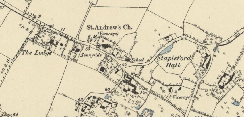
Contents

1.   Introduction                      3    5.   Management, enhancement
                                                 and new development         13
2.   Statement of Community
                                                 5.1   General Advice        13
     Involvement                       3         5.2   New Development       13
3.   History and development           5         5.3   Trees                 14
                                                 5.4   Enhancement           14
     3.1   Location and Setting        5
     3.2   Historic Development        5    6.   Heritage assets and
4.   Character                         7         positive structures         17
     4.1   Summary Description         7
     4.2   Key Characteristics         8
                                            7.   Proposed boundary changes   17
     4.3   Architectural Character     9    8.   References                  19
     4.4   Spatial Character           10
     4.5   Key Views and Landmarks     10
     4.6   Landscape and Open Spaces   12
     4.7   Archaeology                 12

                                                                                  2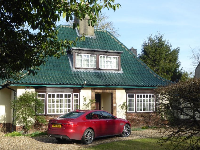
2. Statement of Community
1.Introduction
                                                               Involvement
  Conservation Areas are defined as ‘areas of special
  architectural or historic interest, the character or         The Statement of Community Involvement section will be
  appearance of which it is desirable to preserve or           completed after any comments from the community have
  enhance’1.                                                   been considered and a final version of this draft appraisal is
                                                               put forward for adoption.
  This document sets out the special architectural and
  historic interest of the Stapleford Conservation Area and
  aims to fulfil the District Council’s duty to ‘draw up and
  publish proposals for the preservation and enhancement’
  of its conservation areas as required by the Planning
  (Listed Buildings and Conservation Areas) Act 1990.
  This document covers all the aspects set out by Historic
  England on conservation area appraisals and
  management plans, including an analysis of the special
  character of the conservation area and recommended
  actions for the management of the area in order to
  preserve and enhance its character.

                                                                                                                                3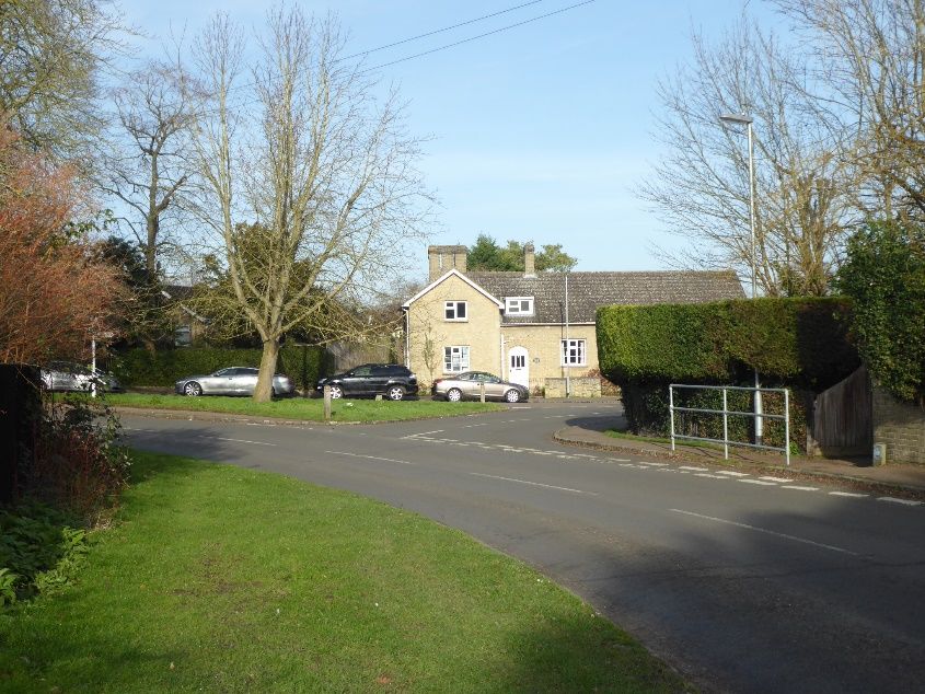
.
Stapleford Conservation Area Map

                                   4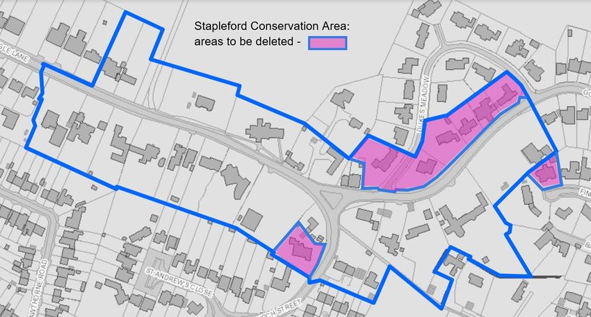
3. History and development
                                                                        Here one of the Icknield Way tracks crossed the
                                                                        riverside route from Great Shelford to Babraham. Small
3.1 Location and setting                                                early Saxon settlements are likely to have been dotted
3.1.1 Stapleford lies on the alluvial and river gravels around          around the crossroads; in 970 the manor is listed as
      the bed of the River Granta. It is within the Chalkland           one of the endowments of the monastery of Ely.
      Landscape Character Area as identified in the District            Named Stapleforde (‘ford marked by a post’) in
      Design Guide SPD. To the north-east the land rises to             Domesday Book, it is recorded as having 27
      the chalk downs of the Gog Magog hills.                           households.

3.1.2 Although Stapleford is close to major road and rail         3.2.2 The village grew around a large green on the site
      routes, the village retains the appearance of a quiet             where Mingle Lane, Church Street and Gog Magog
      rural settlement. This is especially true of the                  Way meet, and the population reached 62 adults by
      conservation area, which is focussed around the early             1377. The Bishop of Ely built a moated manor house a
      medieval parish church and the historic buildings which           short distance to the south (Stapleford Bury), and a
      cluster round it.                                                 parish church was built across the old Icknield Way
                                                                        track to Cherry Hinton. Houses were built on the roads
3.1.3 The surrounding landscape to the south, east and north            which ran around the manor house and alongside the
      is agricultural, primarily large arable fields. There are         church.
      long views over the rising ground to the north of Mingle
      Lane. To the west, the village merges into Great            3.2.3 Stapleford remained a small settlement in late medieval
      Shelford.                                                         times. It expanded eastwards, but its population was
                                                                        only 140 adults by the end of the 17th century. The
                                                                        majority of land around the village was arable. There
                                                                        was also grazing of sheep, especially on heathland in
3.2 Historic development                                                the north of the parish, and in the 17th and 18th
                                                                        centuries, smaller landowners also raised cattle. In
3.2.1 The origins of the village are probably close to the ford         1740, there were 9 farmhouses, 10 other houses, and
      across the Granta to the south of the current village.            14 cottages in the village.

                                                                                                                             5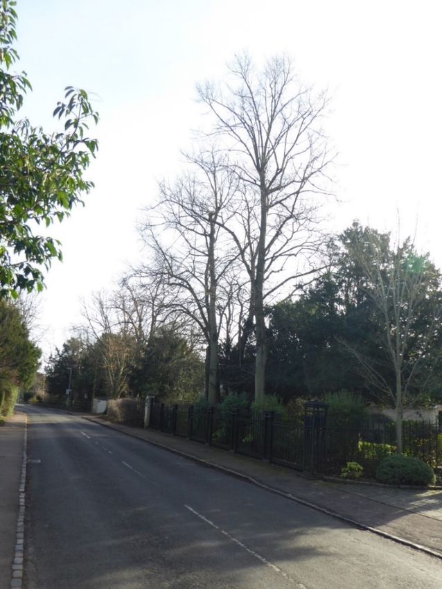
3.2.4 Agricultural innovation was taking place by 1800. A         3.2.5 The popularity of the village as a new residential area
      windmill was constructed in 1804. After enclosure in              continued into the 20th century. Edwardian mansions
      1812 the number of farmers was reduced A National                 were built on Haverhill Road. By 1961 the village had
      School was opened in the old vicarage in 1845. By the             over 490 houses. By the 1980’s many new culs-de-sac
      end of the 19th century, there were just four substantial         had been created, and most of the ancient closes of
      farms. The railway reached nearby Shelford in 1847.               the village were filled with new houses set closely
      This brought a new influx of residents, and there was             together. As a result of this, Stapleford effectively
      much additional building in the area, including large             merged with the neighbouring village of Great Shelford.
      detached houses close to the church on Mingle Lane.
      The population fell again, however, during the
      agricultural depression of the late nineteenth century.

                                                                                                         Northern part of
                                                                                                         Stapleford: Ordnance
                                                                                                         Survey Six-inch Series
                                                                                                         1886
                                                                                                         Reproduced with the
                                                                                                         permission of the National
                                                                                                         Library of Scotland

                                                                                                                              6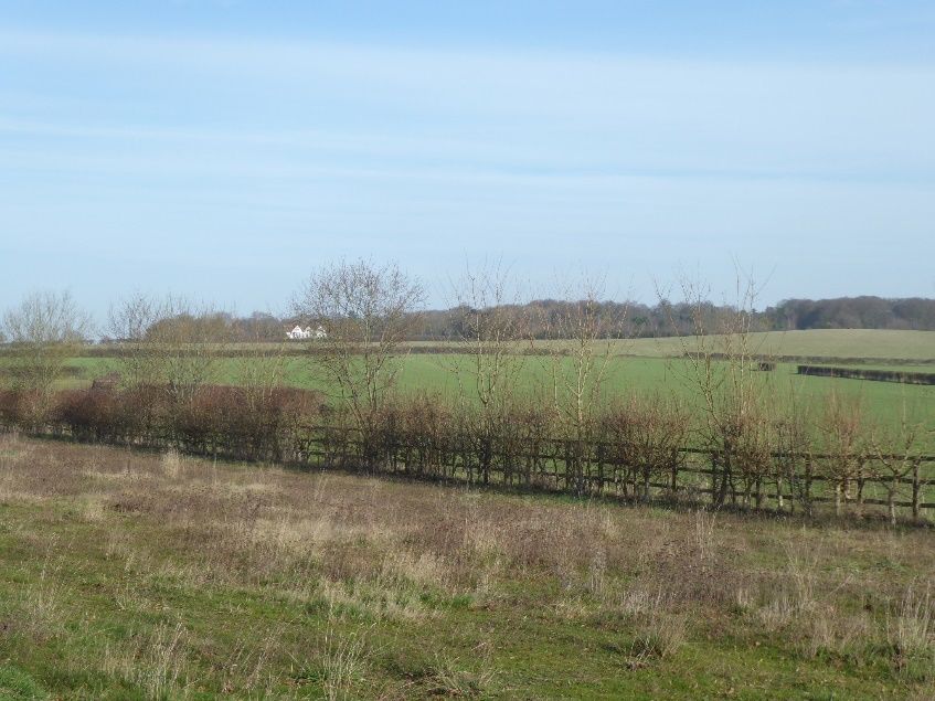
4. Character

4.1 Summary description

4.1.1 Stapleford village has a long history, but in the modern
      era it has become part of the larger settlement of
      Shelford. The conservation area surrounds the historic
      core of Stapleford village, and includes the medieval
      parish church and two of the seven other listed
      buildings in the village.
4.1.2 The triangular green where Mingle Lane meets Church
      Street and Gog Magog Way was the centre of medieval
      Stapleford, but apart from the church and the
      neighbouring White House, few clues to this history
      remain. The conservation area is quiet and sylvan, and
      its character is that of a nineteenth and twentieth-
      century residential area, with glimpses of the
      surrounding countryside, through gaps between
      houses.

      Right: Detached houses from the nineteenth and early
      twentieth century predominate in the conservation
      area, but there is considerable variety in architectural
      character

                                                                 7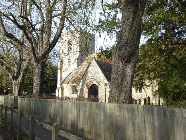
4.2 Key characteristics

    •   Medieval church and triangular green, indicating
        the original village site
    •   Substantial and distinctive detached houses, set
        well back from the street in large plots with
        significant spaces between buildings, mainly from
        the nineteenth and early twentieth centuries, but
        with some modern houses
    •   Sense of enclosure created by curving streets, tall
        hedgerows and substantial areas of mature
        trees
    •   Semi-rural quality of streets arising from grass
        verges, many trees, kerbs of traditional materials,
        and central green at the junction
    •   Long views from the churchyard, and through
        spaces between houses, across the rising chalk
        downs to the north
    •   Retention of small heritage assets in, and
        adjacent to, the public realm, including traditional
        signpost, village sign, post box and railings

    Right above: View north across the rising chalk downs
    Right below: Curving streets and substantial trees; the
    old vicarage/National School building in the centre

                                                               8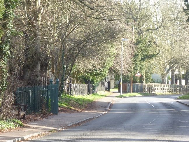
4.3 Architectural characteristics
                  Generally two storeys; some one-and-a-half
                  Mostly substantial detached houses
 Scale and form   Just one timber-framed house, otherwise mostly traditional masonry construction
                  Architecturally varied; C20 buildings include emulation of earlier periods and assertively modern forms
                  Mostly buff brick
     Walls
                  Some white-painted brickwork, some render

     Roofs        Varied, including slate, clay tiles, concrete tiles, pantiles and green glazed tiles
                  Very varied, including timber sashes with both large and small panes, some unorthodox glazing bar patterns,
   Windows        timber casements, mid-twentieth-century steel casements, modern emulations of Victorian timber sashes,
                  uPVC replacements, and modern powder-coated metal.
                  Many substantial hedges
    Boundary      Limited number of low and mid-height brick walls
   treatments     Railings and vertical boarded timber fences used occasionally – mostly recent additions

                                                                       Left: distinctive glazing patterns at 32 and 28 Mingle Lane

                                                                                                                                     9
4.4 Spatial characteristics
4.4.1 The conservation area encloses the meeting point of 4.4.3 The church is set in a substantial churchyard scattered
three roads (Mingle Lane, Gog Magog Way, and with mature trees and some gravestones. There are
Church Street), which was the historic village centre. clear views across the fields to the north.
All three roads curve as they approach the junction, so
4.4.4 The conservation area has a more strongly rural
that views are gradually revealed of the prominent
character than the remainder of Stapleford. This
buildings around the junction, such as 25 Church
character rests mainly on the plentiful trees and
Street, 45 Mingle Lane, 1 Gog Magog Way, and the
hedges, the spacious plots and generous set-back of
church.
buildings, and the glimpses of open countryside to the
4.4.2 Almost all of the buildings in the conservation area are north.
set well back from the street, and in large plots,
although some sub-division of plots has taken place,
most recently to facilitate the construction of two new
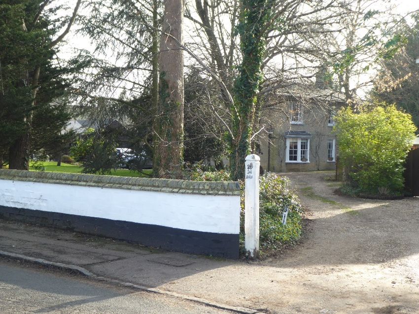
houses at 34 and 34a Mingle Lane. The only buildings
4.5 Key views and landmarks
hard up against the street frontage are the White
House (45 Mingle Lane), a fifteenth-century building 4.5.1 The curving streets, substantial mature trees and high
which may possibly have been a church or a guildhall hedges in the conservation area mean there are few
before its mid-seventeenth century alteration, and 1 landmarks. The only exceptions are the church, and
Gog Magog Way, which dates from the first half of the the two buildings which form a backdrop to the
nineteenth century, and originally contained the triangular green: 25 Church Street, and the old
vicarage and the National School, opened around vicarage / National School at 1 Gog Magog Way. Key
1845. views and landmark buildings are identified on the
conservation area map, and some are shown below.
10Stapleford Conservation Area: landmark buildings and key views
St Andrew’s Church Johnson Memorial Hall 25 Church Street
View east past the church View west along Mingle Lane View towards the green from Gog
Magog Way
114.6 Landscape and open spaces 4.6.5 The churchyard, with its views north to the downs is an
important open space within the conservation area, as
4.6.1 Trees and hedges are very significant to the character
is the triangular green in the centre of the conservation
of the conservation area. They screen many of the
area, which echoes the character of another green to
buildings from public view, either partly or wholly, and
the east, just outside the conservation area in front of
are hence a dominant characteristic of the three
Stapleford Hall. The informal and rural character of the
streets. Trees and hedges also form a backdrop to
green is enhanced by the traditional materials of the
many of the buildings which are visible from the street,
carriageway edging and limited footway paving, the
define spaces and views, and give this part of the
design and materials of the buildings which face it, and
village its shaded and private qualities.
the brick boundary wall of the old vicarage / National
4.6.2 Hedges form the majority of the street boundaries in School building.
Mingle Lane and Gog Magog Way. At the east end of
the conservation area they are mostly above eye- 4.7 Archaeology
height, and more formal. In the centre and east of the 4.7.1 Archaeological work during recent development on the
conservation area there are more mixed heights and southern fringe of Cambridge has shown that the area
greater informality in hedging. Many hedges here are was a densely-settled agricultural area in Romano-
also above eye-height, however. Laurel is a prominent British times; it is probable that Stapleford, only 3km
hedging plant, but many other species are used. south, had a similar pattern of activity in that era.
However, most of the archaeological record around
4.6.3 Groups or areas of trees are especially important to the
Stapleford is focussed on Wandlebury, to the north
character of the conservation area:
east, where there is an Iron Age hill-fort, and Roman
• around the church and the vicarage remains have also been found.
• along the south side of Mingle Lane 4.7.2 Test pit excavations were carried out in the village
• in front of 6, 8 and 8a Gog Magog Way during 2013 to 2017 The sites included several
• behind 25 Church Street gardens within the conservation area: the Vicarage, 38
4.6.4 Individual trees and smaller groups, such as those in Church Street,1 Dukes Meadow and 40 Mingle Lane.
front of 4 Gog Magog Way and in front of 47 Mingle Pottery from a number of different eras was
Lane are also important to the character of the discovered. The latter site at 40 Mingle Lane, close to
conservation area. the green, yielded some Romano-British pottery.
125. Management, enhancement, and new development
5.1 General advice to protect and existing buildings, and on taking opportunities for
enhancement.
enhance the character of the
conservation area 5.2 New development
5.2.1 Beyond domestic extensions, proposals for new
5.1.1 Guidance to promote enhancement of the conservation
development in the conservation area are likely to be
area is provided in the Council’s District Design Guide
either for the subdivision of existing large plots, or for the
SPD and in the Development in Conservation Areas
replacement of existing houses by new ones. Any such
SPD. These two documents were adopted by the
new development should:
Council to support previously adopted Development Plan
Documents that have now been superseded by the • be set well back from the street,
South Cambridgeshire Local Plan 2018. The two • adhere to the scale of existing development, which is
documents are still material considerations when making generally only two storeys,
planning decisions, with the weight in decision making to • contribute to the strongly sylvan quality of the
be determined on a case by case basis having regard to conservation area, by retaining existing trees and
consistency with national planning guidance and the hedgerows and planting new large trees and
adopted South Cambridgeshire Local Plan 2018.Bearing hedgerows.
in mind this proviso, new development should have due • Replicate the characteristic street frontages of the
regard to the two SPD documents, which are available conservation area, using walls and especially
on the Council’s website. hedges,
5.1.2 Sustaining the character of the conservation area into • Avoid designs and layouts which erode the visual
the future will depend on proper management of the character created by single houses in large secluded
existing heritage assets, on care in the design of new plots.
development, including alterations and additions to • Avoid unsympathetic addition of micro-generation
technologies such as solar panels.
135.2.2 Subdivision of plots will be a particularly sensitive issue The replacement of existing forest-scale trees by smaller
in the conservation area in the future. The Mingle Lane species should be resisted, and appropriate new planting of
frontages are especially vulnerable, as there are a larger tree species and Hedges in new development, on
number of very wide plots. Without very careful handling existing plots, and on highway land should be encouraged.
of space and proportion, and imaginative site planning
which maintains the appearance of the existing plots and
avoids radical loss of existing hedges, shrubs and trees, Below: Trees in Mingle Lane, south side
one of the core qualities of this conservation area could
be lost.
5.2.3 Detailed design and materials selection in new
development should take the opportunity to enhance the
character of the area. There is no clear template for new
development in terms of materials or massing, but the
scale, proportions, positioning, orientation, boundary
treatments and landscaping of the existing buildings
provide pointers which will help to avoid harm.
Restrained material palettes for new buildings and the
use of high-quality materials and high-level craft in their
application will also help to enhance the character of the
conservation area.
5.3 Trees
5.3.1 Long-term management of trees is essential to the
character of the conservation area. Such management
needs to both ensure the continued welfare of the existing
trees and plan for enhancement and replenishment.
145.4 Enhancement
5.4.1 The table below sets out detracting elements and
opportunities for enhancement in the conservation area.
Opportunities for Description Management proposal
enhancement
Hardstanding Large, leafy gardens in front of houses are an New hard-surfaced car parking in front of and
important characteristic of the conservation area. alongside buildings facing the street should be
There is little pressure for additional off-street carefully designed. Schemes which include new
parking at present, as most of the houses have trees and hedging plants along the street
substantial driveways, but further sub-division of frontage are positive, and should be
plots is possible. Further extensive paving of the encouraged, but even behind such a screen,
present front garden areas, already evident in large unsoftened areas of paved car parking
Mingle Lane could erode the sylvan character of space should be discouraged.
the conservation area.
Highway engineering Carriageways in the western part of the Encourage the retention of this engineering
conservation area are mostly edged with short approach, especially if new footway crossings
granite kerbstones. The footways are set very are created. Discourage further urbanization of
close to carriageway level. This contributes to the the street surfaces.
rural character of the area.
Boundary treatments Boundary treatments, especially on the street Resist planning applications for inappropriate
frontage, are especially important to the boundary treatments such as close-boarded
conservation area. Hedges are particularly fences or unduly ornate railings, or the removal
important, but there are walls and railings which of existing positive boundaries. Where
also contribute positively. permission is not required for removals,
encourage retention by informal
communication.
15Trees Large trees are of immense importance to the Ensure conservation area controls over tree
character of the conservation area. The trees are works are used to protect existing tall trees, and
located in both public and private spaces. encourage succession planting.
Windows There has been limited replacement of older Promote guidance on traditional windows,
windows in the conservation area, and few outlining their positive contribution to the
instances of such change significantly harming character of a conservation area. When
the character of the area. Nonetheless, the planning permission is required, the loss of
traditional, and in some cases intricate glazing traditional windows should be resisted, and the
patterns are a positive feature of the conservation use of suitable modern windows supported
area. where appropriate. Historic England guidance
is extensive, e.g.: https://historicengland.org.
uk/images-books/publications/traditional-
windows-care-repair-upgrading/
Extensions and alterations Many buildings in the conservation area have Alterations to buildings in the conservation
been substantially extended. Further proposals of area, whether those buildings are identified as
this sort can be expected. making a positive contribution or not, should
respond carefully both to the original character
of the existing building and that of the
conservation area as a whole. Alterations which
eliminate or ameliorate recent poor design, or
restore elements of original character to
buildings should be encouraged.
Signage and lighting Most existing signage in the conservation area is Nonetheless, retention of existing traditional
muted, and of traditional design. There are no signs should be encouraged, and the
commercial premises in the conservation area, introduction of any brash or assertively modern
and the pressure for new signage is likely to be signage and lighting resisted.
minimal
166.2.2 These buildings or structures make a valuable
6. Heritage assets and positive contribution and should be viewed as key elements of
structures the overall character and significance of the relevant
conservation area. Alterations to, or the loss of, these
assets can have a lasting impact on the special
character of the area in which they lie. These structures
6.1 Designated Heritage Assets have been identified as positive buildings on the
6.1.1 There are three listed buildings within the Stapleford conservation area maps.
conservation area boundary: St Andrew’s Church, the
adjacent White House, and Dove Cottage, 4 Gog
Magog Way. 7. Proposed Boundary Changes
6.1.2 Each listed building or structure is identified on the
Conservation Area map, and full details of their listing The proposed boundary changes are listed below and
can be found on the Historic England website at illustrated on the Conservation Area Boundary
www.historicengland.org.uk/listing. Changes Map on page 18.
Proposed deletions to the conservation area:
• Entirety of land belonging to 23 Church Street
6.2 Positive Buildings & Structures • Entirety of land belonging to 5 Finch’s Close
• Entirety of land belonging to 1 and 2a Dukes Meadow,
6.2.1 In addition to the above, there are also about a dozen and the highway between them
buildings or structures which are not nationally • Entirety of land belonging to 7,9,11 and 13 Gog Magog
designated and are unlikely to meet the criteria for Way
consideration as a non-designated heritage asset, but
nonetheless do contribute positively to the character
and appearance of the conservation areas.
17Proposed Conservation Area Boundary Changes
© Crown copyright and database right 2020.
188. References
South Cambridgeshire District Council South Cambridgeshire Local Plan 2018
South Cambridgeshire District Council District Design Guide SPD 2010
South Cambridgeshire District Council Development Affecting Conservation Areas SPD 2009
University of Cambridge / Archaeological Test Pit Excavations in Stapleford, 2013-201 2019
Access Cambridge Archaeology /
Stapleford History Society
19You can also read