Structural Forecasting for Tropical Cyclone Intensity Prediction: Providing Insight with Deep Learning
←
→
Page content transcription
If your browser does not render page correctly, please read the page content below
Structural Forecasting for Tropical Cyclone Intensity
Prediction: Providing Insight with Deep Learning
Trey McNeely1 Niccolò Dalmasso1 Kimberly M. Wood 2 Ann B. Lee 1
1
Department of Statistics & Data Science, Carnegie Mellon University
arXiv:2010.05783v2 [cs.LG] 15 Oct 2020
2
Department of Geosciences, Mississippi State University
imcneely@stat.cmu.edu
Abstract
Tropical cyclone (TC) intensity forecasts are ultimately issued by human forecasters. The human in-the-loop
pipeline requires that any forecasting guidance must be easily digestible by TC experts if it is to be adopted at
operational centers like the National Hurricane Center. Our proposed framework leverages deep learning to
provide forecasters with something neither end-to-end prediction models nor traditional intensity guidance
does: a powerful tool for monitoring high-dimensional time series of key physically relevant predictors and the
means to understand how the predictors relate to one another and to short-term intensity changes.
1 Introduction
Tropical cyclones (TCs) are powerful, highly organized storm systems that help transfer energy from the upper
levels of the world’s oceans to the atmosphere. Increasing coastal populations, concurrent with rising ocean
temperatures due to climate change, increase the dangers (such as storm surge and damaging winds) posed by
TCs. Thus, accurate prediction of TC trajectories and intensities becomes an ever more critical component
of disaster preparation and response. Track forecasting has made great strides since the 1990s, but intensity
forecasting, especially in the short-term 12-h and 24-h windows, have seen less pronounced improvements
[5, 3]. Cases of rapid intensity change (30-knot intensity changes in 24 hours), in particular, have proved
difficult to predict [12, 13, 28].
TC prediction and science rely in part on the relationships between the external environment, internal structure,
and behavior of these storms. For example, vertical wind shear (an external factor) and TC convective patterns
(an internal factor) are both known to relate to TC intensities [6, 13, 11]. Forecasters can access a wide array
of real-time TC observations of both types, but new public forecasts must be issued every six hours by expert
human forecasters. This human-in-the-loop pipeline requires that any forecasting guidance must be easily
understood by TC experts. If the output of a method cannot be digested by scientists in a handful of minutes, it
will not be adopted by stakeholders at operational centers such as the National Hurricane Center (NHC).
The NHC and other operational forecast centers use both physics-based models (dynamical models) and
data-driven models (statistical models) [3]. The Statistical Hurricane Intensity Prediction Scheme (SHIPS [4])
is a particularly successful statistical-dynamical model which largely relates area averages of environmental
fields (such as vertical wind shear) and cloud-top temperatures from infrared (IR) imagery to future TC
intensity change. This IR imagery is available at high spatial and temporal resolutions from satellites like the
Geostationary Operational Environmental Satellites (GOES1 [26, 15]). Structure in IR imagery has long been
known to relate to TC intensity (see the Dvorak technique [6, 20]), but the area-averaged values commonly
used in statistical models discard critical spatial information. The evolution of spatial structure in such fields
correlates with intensity change, but unlocking this rich source of information in IR imagery without sacrificing
interpretability remains an open problem.
We propose a framework to incorporate evolving spatial information into intensity forecasts by utilizing deep
learning (DL) in the high-dimensional time series setting while remaining cognizant of the needs of the end
users: forecasters and scientists. While our end goal is the prediction of short-term intensity changes, our
framework will offer something neither end-to-end models (black-box prediction of intensity directly from IR
imagery) nor existing operational forecasts can: structural summaries or interpretable quantification of the
1
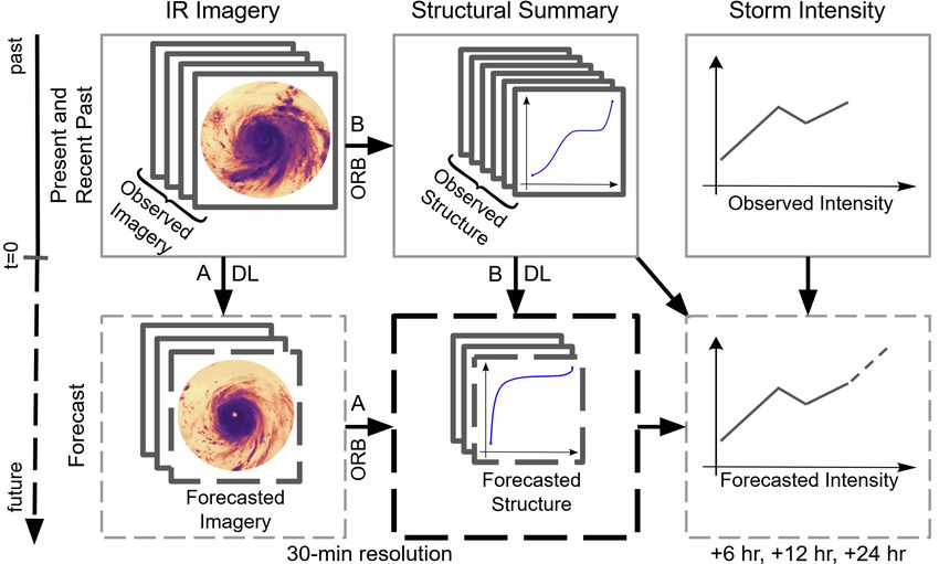
https://www.star.nesdis.noaa.gov/goes/Figure 1: Framework for
combining deep learning
(DL) with structural fea-
tures (ORB) to provide
a structural forecast via
two pathways. Final fore-
casts of intensity (bottom-
right) are based on both
the observed intensity (top-
right) and the observed
and forecasted structure
(center). The interme-
diate structural forecast
is the key contrast with
traditional end-to-end DL
methods.
convective structure of TCs in the form of one-dimensional functions, together with structural forecasts of
the dynamic evolution of these summaries. This new setup will provide forecasters with a powerful tool for
monitoring high-dimensional time series of key physically relevant predictors (like the eye-eyewall structure
and symmetry of deep convection relative to the TC center) with the means to understanding how the predictors
relate to one another and to TC intensity change.
Figure 1 describes our approach. In this figure, the top row indicates observed information, while the bottom
row indicates forecasts; the final intensity forecast (bottom-right) depends on the past intensity (top-right) and
a “structural forecast” (bottom-center) — the predicted short-term evolution of TC structure itself. We obtain
structural forecasts via two paths (A and B). Each approach extracts a set of interpretable features and uses DL
to propagate the structural state of the TC into the near future. These parallel pathways allow forecasters to
check the structural forecasts for agreement via quantitative error metrics in addition to checking them for
physical plausibility directly examining both forecasted imagery and structure. Path A evolves the original IR
imagery via DL and then computes structural features on the forecasted imagery. Path B instead computes
structural features first then evolves them directly via DL. Traditional end-to-end DL approaches step directly
from the observed IR imagery and intensity history to an intensity forecast; our framework’s inclusion of
interpretable structural forecasts as an intermediary step sets it apart from these traditional machine learning
applications.
2 Data
Geostationary satellite observations, including the Geostationary Operational Environmental Satellites (GOES),
provide high spatial (≤4 km) and temporal (≤30 min) resolution imagery of the Atlantic and Pacific TC basins.
Such observations are consistently available, unlike aircraft reconnaissance or land-based instruments such as
radar. We will focus on longwave infrared (∼10.7 µm), which provides estimates of cloud-top temperature.
Because temperature generally decreases with height in the troposphere, low cloud-top temperatures typically
indicate regions of stronger thunderstorms and thus deeper convection. The data collected consist of ∼200,000
IR images (∼400x400 pixels) from 656 unique TCs in the North Atlantic and eastern North Pacific between
2000 and 2019. Storm location and intensity are drawn from the NHC’s HURDAT2 database [17].
3 Providing Insight to TCs via Deep Learning and Forecasted Structure
The ultimate goal of this work is to leverage evolving spatial structures in TCs to better understand storm
behavior, specifically short-term storm intensity change (6- to 24-hour time frame). We would like to answer
the question “Can we predict short-term intensity change using interpretable features from GOES-IR?"
Preliminary Work. In prior work [19], we have shown that a set of interpretable structural features drawn
from GOES-IR imagery can nowcast (that is, predict ongoing) rapid intensity changes as well as SHIPS
environmental predictors. Our approach extracted a set of ORB functions summarizing the Organization,
Radial structure, and Bulk morphology of a TC image as continuous functions (of, e.g., the radius r from
the TC center or the threshold c of level sets). The ORB functions were then compressed via a principal
component analysis (PCA), and the PC coefficients served as inputs to logistic lasso models which classified
2the storms as rapidly changing in intensity or not. The (generalized) linear model allowed the user to directly
relate the probability of a rapid TC intensity change to changes in key physical predictors like the eye-eyewall
structure and symmetry of deep convection in the storm core. Our initial ORB suite performed as well as a
subset of area-averaged SHIPS environmental predictors, while the combination of the two sets outperformed
SHIPS alone. For reliable intensity forecasting, however, we need a richer suite of ORB functions, as well as a
tool for projecting high-dimensional ORB functions Xt ∈ Rd (where d is very large) into the future without a
prior dimension reduction.
Structural Summaries. In the proposed work, we will develop a richer suite of structural summary functions
that also includes center-independent structural features, measures of the spatial structure of vector fields, and
additional satellite observations such as water vapor (∼ 6.5µm) imagery. Crucially, we will compare our final
intensity forecasts based on these structural features with intensity forecasts resulting from end-to-end DL
models; in this way, we can assess the richness of the feature suite and quantify information lost in compression
w.r.t. the root mean squared (RMS) intensity prediction errors. Instead of focusing on exhaustive feature
design, we will predominantly explore new classes of features to improve the range of physical structures
quantified by ORB.
Structural Forecasting. In lieu of an end-to-end deep learning model, we will project our structural summaries
of the TC 6, 12, and 24 hours into the future via DL; instead of only answering “How strong will the TC be in
6/12/24 hours?” we will also model “What will the TC look like in 6/12/24 hours?” This approach will provide
the critical next step in the prediction pipeline, which enables forecasters to examine the structural forecast
before relying on the intensity model. Since they can compare the forecast to the original satellite imagery,
this improves stakeholder trust in the model, providing additional clues to the emergence of unrealistic TC
structures or trajectories. Furthermore, this framework mimics the utilization of numerical weather models
by statistical-dynamical intensity guidance; such models use physical laws rather than statistical learning to
forecast the state of the atmosphere, but the final intensity guidance (e.g., SHIPS) still draws on summaries of
this atmospheric forecast in the same way we will draw on a structural forecast.
We will generate structural forecasts via two pathways. The first of these (in Figure 1, pathway A) steps the
TC imagery forward in time, then computes ORB functions at each time step. This could be achieved using
convolutional neural network architectures used in frame-to-frame prediction (as in [1, 8]; see [21] for an
exhaustive review). As video prediction tasks can be challenging, a modified version of this pathway could
have deep convolutional architectures forecast intensity directly [23, 14, 9]; i.e., an end-to-end model going
straight from the top left to the bottom right of Figure 1. The second route (in Figure 1, pathway B) will
directly step the ORB features forward in time, thus optimizing for the outcome of interest (TC structure).
While linear auto-regressive models such as ARIMA [2] are appropriate, we plan on leveraging recurrent
neural networks [7], which have been shown to be successful in multivariate time series prediction tasks
[29, 22, 16, 24] (see [18] for a recent review). Comparing the output of pathways A and B will allow us to
compare the impact of using interpretable structural features on the accuracy of structural forecasts against
those automatically extracted by deep learning models.
From Structure to Intensity. Traditional linear models have historically been attractive to forecasters and
scientists for reasons of interpretability and good performance in low sample size settings. However, linear
models often struggle to capture the complex, time-varying processes which drive these storms. We here
propose an approach that leverages DL to handle the high-dimensional structural forecasting problem, while the
relationship between structure and intensity is handled by additive models (generalized additive models [10],
sparse additive models [25], etc.). Additive models are attractive due to their combination of high-capacity,
ease of interpretation, and straightforward visualizations. Importantly, these additive models have access to a
structural forecast; the heavy lifting of high-dimensional time series prediction is handled by the deep learning
models. In addition to this regression problem, comparison of trajectories via spectral clustering will be used
to identify modes of evolution [27]. Such identification of similar trajectories in historical TCs can provide
forecasters and scientists alike with analogous TCs against which to compare the evolution of new storms.
Evaluation Metrics. We will have two quantitative metrics for the performance of this framework. First,
we will compare the resultant RMS intensity errors and bias at 6, 12, and 24 hours to both end-to-end DL
and to the official NHC forecasts for those times. Second, we will compare the L2 -distance between the
resultant structural forecasts from the two pathways (to assess “sufficiency” of tracking only ORB features)
as well as distance from the ground truth structural features. We acknowledge that a model based solely on
satellite imagery with limited atmospheric and oceanographic data will not outperform state-of-the-art intensity
prediction schemes on its own. However, a successful model which relates structural evolution to intensity
change will be an invaluable addition to the toolbox utilized by forecasters and scientists analyzing TCs.
3References
[1] Mohammad Babaeizadeh, Chelsea Finn, Dumitru Erhan, Roy H. Campbell, and Sergey Levine. Stochastic
variational video prediction. arXiv e-prints, page arXiv:1710.11252, October 2017.
[2] George.E.P. Box and Gwilym M. Jenkins. Time Series Analysis: Forecasting and Control. Holden-Day,
1976.
[3] John P. Cangialosi, Eric Blake, Mark DeMaria, Andrew Penny, Andrew Latto, Edward Rappaport, and
Vijay Tallapragada. Recent Progress in Tropical Cyclone Intensity Forecasting at the National Hurricane
Center. Weather and Forecasting, 35(5):1913–1922, 08 2020.
[4] Mark DeMaria and John Kaplan. An updated statistical hurricane intensity prediction scheme (SHIPS)
for the Atlantic and Eastern North Pacific basins. Weather and Forecasting, 14(3):326–337, 1999.
[5] Mark DeMaria, Charles R. Sampson, John A. Knaff, and Kate D. Musgrave. Is tropical cyclone intensity
guidance improving? Bulletin of the American Meteorological Society, 95(3):387–398, 2014.
[6] Vernon F. Dvorak. Tropical cyclone intensity analysis and forecasting from satellite imagery. Monthly
Weather Review, 103(5):420–430, 1975.
[7] Jeffrey L. Elman. Finding structure in time. Cognitive Science, 14(2):179–211, 1990.
[8] Jean-Yves Franceschi, Edouard Delasalles, Mickaël Chen, Sylvain Lamprier, and Patrick Gallinari.
Stochastic latent residual video prediction. Proceedings of the International Conference on Machine
Learning, 2020.
[9] Sophie Giffard-Roisin, Mo Yang, Guillaume Charpiat, Christina Kumler Bonfanti, Balázs Kágl, and
Claire Monteleoni. Tropical cyclone track forecasting using fused deep learning from aligned reanalysis
data. Frontiers in Big Data, 3:1, 2020.
[10] Trevor J Hastie and Robert J Tibshirani. Generalized additive models, volume 43. CRC press, 1990.
[11] Liang Hu, Elizabeth A Ritchie, and J Scott Tyo. Short-term tropical cyclone intensity forecasting
from satellite imagery based on the deviation angle variance technique. Weather and Forecasting,
35(1):285–298, 2020.
[12] John Kaplan, Mark DeMaria, and John A. Knaff. A revised tropical cyclone rapid intensification index
for the Atlantic and Eastern North Pacific basins. Weather and Forecasting, 25(1):220–241, 2010.
[13] John Kaplan, Christopher M Rozoff, Mark DeMaria, Charles R Sampson, James P Kossin, Christopher S
Velden, Joseph J Cione, Jason P Dunion, John A Knaff, Jun A Zhang, et al. Evaluating environmental
impacts on tropical cyclone rapid intensification predictability utilizing statistical models. Weather and
Forecasting, 30(5):1374–1396, 2015.
[14] S. Kim, H. Kim, J. Lee, S. Yoon, S. E. Kahou, K. Kashinath, and M. Prabhat. Deep-hurricane-tracker:
Tracking and forecasting extreme climate events. In 2019 IEEE Winter Conference on Applications of
Computer Vision (WACV), pages 1761–1769, 2019.
[15] K. R. Knapp and S. L. Wilkins. Gridded satellite (GridSat) GOES and CONUS data. Earth System
Science Data, 10(3):1417–1425, 2018.
[16] Guokun Lai, Wei-Cheng Chang, Yiming Yang, and Hanxiao Liu. Modeling long- and short-term temporal
patterns with deep neural networks. In The 41st International ACM SIGIR Conference on Research &
Development in Information Retrieval, SIGIR ’18, page 95–104, New York, NY, USA, 2018. Association
for Computing Machinery.
[17] Christopher W. Landsea and James L. Franklin. Atlantic hurricane database uncertainty and presentation
of a new database format. Monthly Weather Review, 141(10):3576–3592, 2013.
[18] Bryan Lim and Stefan Zohren. Time series forecasting with deep learning: A survey. arXiv preprint
arXiv:2004.13408, 2020.
[19] Trey McNeely, Ann B. Lee, Kimberly M. Wood, and Dorit Hammerling. Unlocking goes: A statistical
framework for quantifying the evolution of convective structure in tropical cyclones. arXiv preprint
arXiv:1911.11089, 2020.
[20] Timothy L Olander and Christopher S Velden. The advanced dvorak technique (adt) for estimating
tropical cyclone intensity: Update and new capabilities. Weather and Forecasting, 34(4):905–922, 2019.
[21] Sergiu Oprea, Pablo Martinez-Gonzalez, Alberto Garcia-Garcia, John Alejandro Castro-Vargas, Sergio
Orts-Escolano, Jose Garcia-Rodriguez, and Antonis Argyros. A review on deep learning techniques for
video prediction. arXiv e-prints, page arXiv:2004.05214, April 2020.
[22] Yao Qin, Dongjin Song, Haifeng Cheng, Wei Cheng, Guofei Jiang, and Garrison W. Cottrell. A dual-
stage attention-based recurrent neural network for time series prediction. In Proceedings of the 26th
International Joint Conference on Artificial Intelligence, IJCAI’17, page 2627–2633. AAAI Press, 2017.
4[23] Evan Racah, Christopher Beckham, Tegan Maharaj, Samira Ebrahimi Kahou, Mr. Prabhat, and Chris
Pal. Extremeweather: A large-scale climate dataset for semi-supervised detection, localization, and
understanding of extreme weather events. In I. Guyon, U. V. Luxburg, S. Bengio, H. Wallach, R. Fergus,
S. Vishwanathan, and R. Garnett, editors, Advances in Neural Information Processing Systems 30, pages
3402–3413. Curran Associates, Inc., 2017.
[24] Syama Sundar Rangapuram, Matthias W Seeger, Jan Gasthaus, Lorenzo Stella, Yuyang Wang, and
Tim Januschowski. Deep state space models for time series forecasting. In S. Bengio, H. Wallach,
H. Larochelle, K. Grauman, N. Cesa-Bianchi, and R. Garnett, editors, Advances in Neural Information
Processing Systems 31, pages 7785–7794. Curran Associates, Inc., 2018.
[25] Pradeep Ravikumar, John Lafferty, Han Liu, and Larry Wasserman. Sparse additive models. Journal of
the Royal Statistical Society: Series B (Statistical Methodology), 71(5):1009–1030, 2009.
[26] Timothy J Schmit, Paul Griffith, Mathew M Gunshor, Jaime M Daniels, Steven J Goodman, and William J
Lebair. A closer look at the ABI on the GOES-R series. Bulletin of the American Meteorological Society,
98(4):681–698, 2017.
[27] Ulrike Von Luxburg. A tutorial on spectral clustering. Statistics and computing, 17(4):395–416, 2007.
[28] Kimberly M Wood and Elizabeth A Ritchie. A definition for rapid weakening of North Atlantic and
Eastern North Pacific tropical cyclones. Geophysical Research Letters, 42(22):10–091, 2015.
[29] Rose Yu, Stephan Zheng, Anima Anandkumar, and Yisong Yue. Long-term forecasting using higher
order tensor RNNs. arXiv e-prints, page arXiv:1711.00073, October 2017.
5You can also read