Switch On! How utilities use Google Maps to keep service flowing - Maps for Business
←
→
Page content transcription
If your browser does not render page correctly, please read the page content below
Maps for Business

Switch On!
How utilities use Google Maps
to keep service flowing
Maps for Business

Editorial

Empowering today’s utility industry with Google Maps
for Business
Utility companies have a lot of information and assets to manage. From water to electric power, demand
for clean, reliable energy is at an all-time high. This puts even more pressure on the industry to find the
best solution for improving operations, whether it’s integrating simple asset management, investing in
visualization tools or integrating real-time communications with customers.

Google Maps for Business brings the power of Google Maps and Google Earth to an organization improving
decision making, optimizing operations and creating engaging applications. Its scalable, familiar technology
offers a diverse set of map applications, APIs and cloud-enabled tools that are fully customizable. When
applied to utilities companies, Google’s enterprise mapping solutions can let organizations see their data
layered on a Google Map and securely share this information with employees, key stakeholders and the
public.

In this little booklet, you will read stories from companies around the globe in the utilities space who have
opted for easy-to-use mapping technologies as a way to optimize operations.

By adopting Google Maps for Business, these companies are changing the way they manage jobs,
streamline and consolidate processes and better engage with their customers.

I hope you will find it useful and if you want to know more, please check our web site www.maps.google.
com/utilities

Tarun Bhatnagar, Director, Google Maps for Business
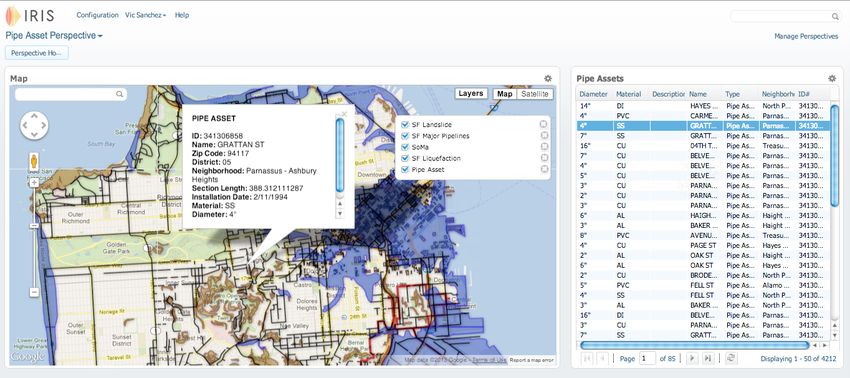
Table of Content

• GeoDigital keeps power flowing and improve vegetation
  management

• GrDF makes dynamic use of maps for customers and
 employees

• Powercor drives innovation and enhances customer service

• Sutton & East Surrey Water improves operations &
  productivity of meter fitting and repair teams

• Florida Power & Light keeps customers out of the dark

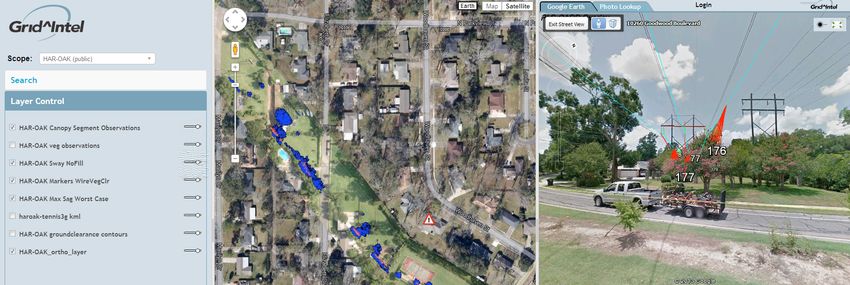
Maps for Business

GeoDigital helps keep power flowing with Google Maps Engine
Next time you switch on a lamp or a TV, you may have a company named GeoDigital—along with Google
Maps for Business—to thank for it. Why? Because more and more electric utilities are using their combined
technologies to keep the power flowing.
A single failure in an electrical transmission network—say, a tree falling onto an electrical conductor— can
trigger a chain reaction of automatic shutdowns and additions failures, resulting in massive outages that can
last days. So utilities must constantly monitor for existing and potential threats to transmission lines and towers,
transformers, substations and other equipment.
GeoDigital helps utilities address the fast growing and heavily regulated aspects of engineering and vegetation
management in both transmission and distribution markets, with solutions incorporating LiDAR (3-D laser
mapping), digital imaging, and visualization technologies.
Google Maps Engine and Google Earth give end users a familiar and intuitive way to plan routine maintenance—
think tree trimming and grass mowing—and to manage response activities. By providing a visual, geographic
context for asset and threat data, Google Earth enables utility personnel to remotely visit and inspect locations—
without leaving their offices.
Field personnel can access the same, map-based information using mobile devices, making it easy for people
in the office to coordinate with remote teams. Office personnel can assign work packages to field teams, with
remote users receiving these alerts on their smartphones and tablets. They can then use a familiar, intuitive
app interface to retrieve information and coordinate with the office.
Thanks to these GeoDigital, Google, and a lot of dedicated utility workers, the trees stay trimmed—and the
power stays on.

Geospatial Solution Provider: GeoDigital
Challenge
 • Help utilities monitor and manage widespread networks for existing and potential threats
Solution
 • LiDAR 3D laser mapping, digital imaging, and geographic visualization for vegetation management using
   Google Maps Engine and Google Earth
Results
 • Familiar, intuitive app lets workers virtually visit and inspect remote locations without leaving the office
 • Improved coordination and communication with field personnel with smartphone- and tablet-based access
 • More efficient network maintenance; more effective emergency response

Maps for Business

IRIS Maps helps utilities better manage right of way
With miles and miles of underground pipeline and transmission lines to manage, utilities must quickly locate
and track their assets. Envista, provider of cloud-based right-of-way coordination solutions, created its IRIS
solution to meet this specific need.
This cloud-based, Platform-as-a-Service (PaaS) technology enables utilities to create custom map applications,
with no need for complex coding. By incorporating a utility’s asset and location data into a single platform,
IRIS lets end users quickly and easily access the information they need, in geographical context, to efficiently
maintain critical assets in the field.
The secret behind IRIS technology? Google Maps Engine, which brings three key benefits to utilities. First, its
large-scale information and image-processing power easily manages the high-volume, high-resolution maps,
layers and geospatial data required.
• Scale: Large-scale information and image-processing power easily handles the high-volume, high-resolution
  maps, layers and geospatial data required to readily serve busy utility staff.
• Familiarity: IRIS apps users can see their data a Google Map. The simple user interface and detailed Google
  Earth imagery lets users understand what they see on a map, with very little training.
• Mobility: The Google Maps Engine cloud platform allows IRIS maps to be used in almost any environment —
  mobile, remote or offline.
“Map-based asset management is critically important in the utility industry,” says Envista CEO Mark Prestipino. “To
make sure our customers have a solution they can rely on, Google Maps Engine is the clear choice for Envista.”

Cloud Right-of-way Solution: IRIS Maps
Challenge
 • Help utilities track and manage distribution networks with asset and location data in a usable format
Solution
 • Cloud-based PaaS for creating customized, map-based applications, featuring Google Maps high-res maps,
   layers and imagery
Results
 • Users require little to no training
 • Mobile, remote or offline users all have access to easily understood data
 • New map-based apps can be created quickly and easily
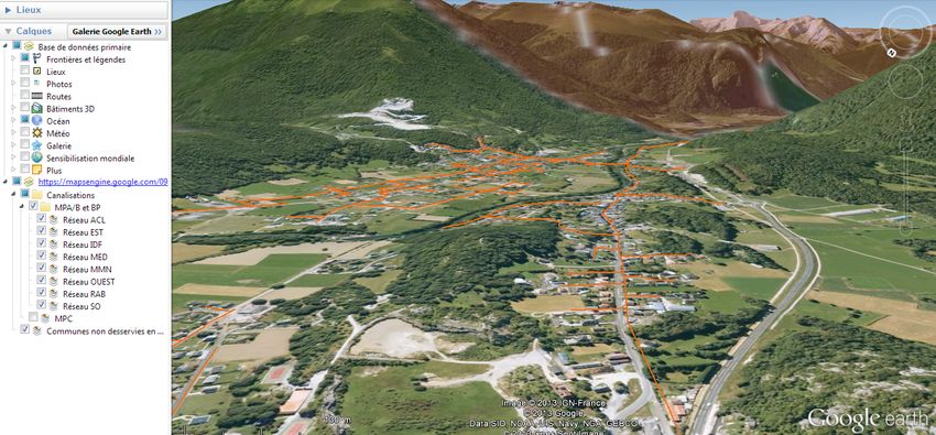
Maps for Business

GrDF makes dynamic use of maps for customers and employees
When you move to a new location in France, Google may very well help you get your furnace running, your stove
cooking and your water heating.
That’s because GrDF — a natural gas utility serving 11 million customers across France—uses Google mapping
technology to help manage its network of more than 194,600 km of pipeline and a workforce of more than 12,000.
To more efficiently help its customers, GrDF created Gazm@ps Raccordabilité, a web-based geographic search
service that lets people use map, satellite and street views to specify addresses where they want gas service.
Users can also provide their contact and requirements information, which is forwarded via email to a GrDF
customer advisor. The advisor—with the help of the same maps and street views—makes final arrangements
with the new customers.
Combining the utility’s extensive Smallworld GIS database with the familiar Google Maps user interface, Gazm@
ps Raccordabilité now helps customers locate over 10,000 addresses monthly. “The solution was implemented
very rapidly, with little need for infrastructure,” says Pascale Bernal, Director of GrDF Information Systems. “Because
moving to the web is so important for us, our return on investment is significant.”
Following this success, the GrDF IT unit has created additional mapping-centric solutions for use by its internal
sales, technical and management teams. Now, more than 1,000 employees use the same mapping tools they
use in their daily lives to view customer relationship, location, and technical information.
One more win: costs are lower. The Gazm@ps Dev application, which serves sales teams, operates at 60%
lower costs than the older system it replaced.

Natural gas utility: GrDF
Goals
 • Streamline processes, shift customer support online, cut costs
Solution
 • Web-based mapping “app” for requesting service
 • Internal map-based apps for sales, tech & management teams
Results
 • 10,000 service inquiries monthly moved from phone to more cost-effective web
 • 60% lower system costs
 • Improved customer service
Maps for Business

Powercor drives innovation and enhances customer service
Powercor distributes and delivers electricity to homes and businesses in Melbourne, Australia and widespread
surrounding areas. Key to this work is managing assets—poles, wires, meters, power stations and more—in
order to optimize cost, reliability and safety. Powercor also works to prevent or respond to equipment faults,
outages, bush fires and other issues.
To achieve these goals, Powercor staff needs to “see” relevant asset data—along with more information from
a range of third-party sources—in the context of a given outage or other incident. But the company’s existing
geographic information system was overly complex and training-intensive. The IT team, also seeking a better
way to visualize data housed in its SAP Enterprise Asset Management software, sought an alternative solution.
“We chose Google Earth Enterprise,” explains Powercor Distribution Network IT Manager Tony Matheson, “for
its powerful 3D visualization technology that anyone can use—without the need for training. We also liked the low
investment involved, and the fact that we could see benefits right away.”
Matheson’s team used the Google Earth API to create a customized “virtual globe,” securely housed in an onsite
server behind the company’s firewall. They also built a data warehouse that stores the status of roughly 600,000
power poles, customer information, asset and maintenance images and other data.
“Now we can quickly create maps and share them, so everyone has a consistent and familiar experience,” says
Matheson. The IT team can often deliver a new, mapped data layer on the same day a new business need
arises.
With Google Earth in place, Powercor delivers better, faster, more efficient service to customers, and responds
more quickly and effectively when situations occur. “Now, we’re more innovative,” says Matheson. “And we’re more
agile.”

Electric utility: Powercor
Goals
 • Optimize network reliability, safety and costs
Solution
 • “Virtual Globe” solution incorporating Google Earth Enterprise
 • Map-based views of SAP-housed asset and customer info
Results
 • Improved, faster, and more efficient service to customers
 • Faster, more effective responses to outages
Maps for Business

Sutton & East Surrey Water improves operations & productivity
of meter fitting and repair teams with Google Maps Coordinate
Sutton & East Surrey Water, a water utility serving 655,000 consumers in southeast England, wanted greater
efficiency in maintaining its water network, and in its large-scale program to replace 24,000 aging meters.
To assign installation and maintenance work each day, the company printed hundreds of work orders, hand-
sorted them into rough geographical batches, and handed them off to installers who planned their own routes
using maps and local knowledge. Installers documented each completed job on a paper form, handing it in
the following day for entry into a billing system. Maintenance and repair work involved additional paperwork
around permits, technical documentation, health and safety.
Efficiency suffered--and the delays involved meant customer service teams often had outdated information
when assisting customers. Some delays resulted in penalty charges assessed by local governments.
Today, Sutton and East Surrey Water uses Google Maps Coordinate to visually track employees in the field in
real-time. Job information from the company’s in-house job control system is plotted onto a Google Map that
remote workers can view on 3G-enabled, seven-inch tablets. Workers can then use the same app to record job
data that’s fed automatically back to headquarters.
The results? Productivity in the field is up 17%, while customer service reps can provide swift, detailed answers

to customers. Annual operational costs are £16,000 lower, and government penalty charges are down 58%.
“We’ve seen tremendous benefits since using Google Maps Coordinate, and see huge potential for improving our
working practices even further,” says Jeremy Heath, the utility’s Network Manager. “When you look at all the savings,
from fuel to printing to parking, we’ve seen an annual ROI of 500%, which is very impressive.”

Water utility: Sutton & East Surrey Water
Challenge
 • Simplify processes, boost
   productivity and efficiency
Solution
 • Google Maps Coordinate,
   deployed on tablets for use by
   installation and maintenance
   teams
Results
 • 17% increase in operational
   efficiency
 • £25K/$39K annual savings in
   administration time
 • Improved customer service
 • 58% reduction in delay-related
   government penalties
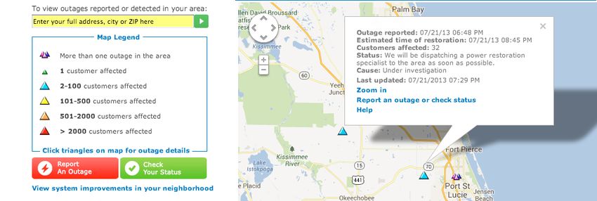
Maps for Business

Florida Power & Light Company uses Google Maps
to help keep customers out of the dark
Florida Power & Light is the largest electric utility in Florida, serving more than 4.6 million customers. Keeping
the lights on requires the utility’s Customer Service, Distribution and Transmissions teams to have quick access
to more than a million points of data, covering everything from meters and physical assets to work orders,
crews and trucks—even eagle nests, conservation areas and weather.
With Florida’s occasionally extreme weather, power outages are common—and customers want to know when
service will resume, while utility crews need to determine how to effect repairs. In both cases, making the
information easily accessible and digestible can save time, reduce costs and help customers cope.
FP&L makes extensive use of Google Maps for Business to meet these needs. One solution, Restoration Spatial
View, displays severe weather, trouble tickets, crews, trucks and the power status of meters—all on the familiar
Google Maps satellite map. Crews can use an intuitive, visual interface—on truck-based laptops or more than
300 go-anywhere tablets—to get the information they need to locate and repair problems. The result? Average
per-customer outages are a full 20% shorter in duration, and record-high reliability.
A second, web-based solution, FPL Power Tracker, lets customers search for and report outages on a web
page. Customers can click to see an outage’s cause, expected repair time and more. A Storm Mode option lets
customers retrieve county-by-county outage information.
“Florida’s storms are powerful,” says FP&L Distribution Business Systems Manger Kirk Suscella. “Thanks to Google
Maps for Business and its flexible APIs, FPL crews have powerful tools for keeping our customers’ lights on.”

Electric utility: Florida Power & Light
Challenge
 • Extreme weather, widespread network, extensive data and dependent customers
Solution
 • Restoration Spatial View app: displays critical data on Google satellite map, helps crews locate & repair
   trouble
 • FPL Power Tracker app: web-based geo search tool helps customers report & track outages
Results
 • Per-customer outage duration cut by 20%
 • Well-informed customers can plan for return to normal activities
You can also read