The Danish Slave Cadaster on St Croix, US Virgin Island
←
→
Page content transcription
If your browser does not render page correctly, please read the page content below
The Danish Slave Cadaster on St Croix, US Virgin Island

         Camilla KNUDSEN, Terese THODE and Esben Munk SØRENSEN, Denmark

   Key words: Cadaster, Slaves, St. Croix,

   SUMMARY

   St. Croix was under danish territory from 1733 to 1917, and in that period the Danes
   colonized the island to produce sucker. When the Danes bought the island in 1733, the island
   was impassable due to the overgrown terrain, which made it very hard to survey the island
   and make plantations, who could be used for sucker production. With hard work, the danish
   surveyors managed to form properties for plantations. To survey the plantations and to
   produce sucker, the danish surveyors and plantation owners used slaves. In the 18th century
   on St. Croix, the slaves were seen as a property. The slaves were therefore registered in the
   cadastral system on St. Croix, which isn't seen in the danish cadastral in the 18th century. The
   differences between the cadastral system on St. Croix and the cadastral system in Denmark
   has created a wonder of, how the systems are different from each other, and what significance
   the cadastral system on St. Croix has had both on the island, but also in Denmark and maybe
   the rest of the world. The master-study, therefore, investigate the difference between, what is
   registered in the cadastral system and how the surveyors surveyed the properties on St. Croix,
   unlike how it was done and registered in Denmark.
   The results of this master-study document shows that the difference between the danish
   cadastral and the cadastral on St. Croix was not how they used the cadastral but how they
   perceived the properties. The surveying was also different from each other. In Denmark, there
   were already existing boundaries from agriculture when the land was surveyed for the
   cadastral. There were only a few inhabitants on St. Croix when the danish surveyors surveyed
   the island and therefore there were no exiting boundaries. The method, that the surveyors
   used, was first to survey a centerline, which could be used as a baseline to survey the
   plantations. St. Croix was then surveyed in a rectangular grid and this surveying method is to
   be identical to the method, that they used to survey the mainland in the USA. Hugh
   Williamson and Thomas Jefferson claim to be the ones, who came up with the surveying
   method in 1784, and apparently, the method is not used earlier according to multiple sources.
   But St. Croix is surveyed in 1733, which is about 50 years earlier than the USA, so our thesis
   is that the danish surveyors might be the first with the idea and maybe they are the founders of
   the surveying method, that is used in the USA.

The Danish Slave Cadaster on St Croix, US Virgin Island (11146)
Camilla Knudsen, Terese Thode and Esben Munk Sørensen (Denmark)
FIG e-Working Week 2021
Smart Surveyors for Land and Water Management - Challenges in a New Reality
Virtually in the Netherlands, 21–25 June 2021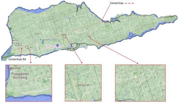
The Danish Slave Cadaster on St Croix, US Virgin Island

         Camilla KNUDSEN, Terese THODE and Esben Munk SØRENSEN, Denmark

       1. Introduction

   The Danish chapter in the history of the West Indies started when the Danish king Christian
   the 5th sent a ship to the West Indies in 1672, where the purpose was that he wanted a share in
   the foreign sugar business. In the same year, Christian the 5th conquered St. Thomas. Earlier,
   in 1658, his father, king the Frederik 3rd's soldiers, had conquered the fort Carolusborg on the
   African Gold Coast. These conquests and the establishment of sugar plantations at St. Thomas
   started a greatness in the Danish colonial history, where Denmark was a part of the triangle
   trade with the export of weapons and gunpowder to Carolusborg on the Gold Coast in
   exchange for slaves, who were transported to the West Indies. Here, Danish merchants
   received exotic goods such as cotton, tobacco, sugar, and coffee in exchange, which were
   sailed home to Denmark and benefited the Danish economy through property tax.
   (Sundstrøm, 2017)
   46 years later in 1718, the Danish colonies territory increased, when king Frederik the 4th
   conquered St. John. The Danish colony increased once again in 1733 when the West Indies-
   Guinea Company bought St. Croix. The West Indies-Guinea Company consisted of king
   Christian the 6th and several nobles in Denmark1. (Brimnes, 2020)
   How St. Croix became a part of the Danish territory, was different from the other two islands
   because the West Indies-Guinea Company bought the island from the French minister
   Maurepas instead of a military conquest (Christiansen, 1982). The West Indies-Guinea
   Company was interested in buying St. Croix because there was no more land to cultivate on
   the remaining two islands. Also, the land was depleted of many years of cultivation of the
   same crops. The reason for the choice of St. Croix was its location close to Puerto Rico as
   well as the fact that the land was not already cultivated. This allowed the West Indies-Guinea
   Company to organize the sugar plantations as they wished. (Bro-Jørgensen, 1953)
   This is where the story of Danish mapping and surveying started in St. Croix as the king and
   the West Indies-Guinea Company needed to create an infrastructure to ensure the formation of
   property and tax revenues, and that’s where the cadastre plays an important role.
   The West Indies-Guinea Company had a major task in exploiting land that was dominated by
   wild nature and in how king Christian the 6th could collect taxes so that economic gain could
   be obtained for royal power. The directors of the West Indies-Guinea Company in
   Copenhagen had an idea of how the surveying of St. Croix was to take place. Instructions on
   these surveying methods were sent to Governor Frederik Moth of St. Croix through some
   general letters containing notices, information, inquiries, etc., but also detailed instructions,

   1
    The West Indies-Guinea Company existed from 1671 to 1754, and was a trading company granted by the king,
   and had the exclusive right to sail to the West Indies and occupy and build the islands. They also had a
   monopoly on sailing and extracting raw sugar in Denmark and Norway. The West Indies-Guinea Company also
   had all the privileges in Africa (Guinea), which makes up the name. (Brimnes, 2012)

The Danish Slave Cadaster on St Croix, US Virgin Island (11146)
Camilla Knudsen, Terese Thode and Esben Munk Sørensen (Denmark)
FIG e-Working Week 2021
Smart Surveyors for Land and Water Management - Challenges in a New Reality
Virtually in the Netherlands, 21–25 June 2021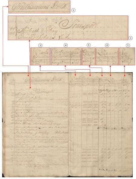
recommendations, or orders as to how the surveying should be conducted. (Christiansen,
   1982) Even though the detailed instructions intended to subdivide St. Croix, the directors of
   the West Indies-Guinea Company had not expected that the island was overgrown with
   tropical forests and the island had very steep hills, which was very different from what the flat
   Danish terrain looked like. (Bro-Jørgensen, 1953) There was therefore a challenge because
   the directors of the West Indies-Guinea Company had planned to measure St. Croix with
   some comparable methods who was used Denmark, as Denmark had been measured at the
   end of the 17th century. But it was not possible to use the same methods on St. Croix as in
   Denmark, and therefore there was a need to find another solution for surveying St. Croix.
   Therefore, the question and the wonder in this study are concerning how different the property
   registration on St. Croix was in relation to the Danish when you consider that the cadastral
   narrative has not previously described the slave cadaster.

       2. Registration of the cadaster on St. Croix

   To get the cultivation started on St. Croix, there was made an initiative that consisted of
   everyone who began their cultivation of sugar was being exempted from paying taxes for
   seven years. These years were called the years of freedom. Furthermore, they could wait six
   years to pay for the property they had bought, but they had to pay six percent interest rate for
   each year. At the same time, a three-year duty-free regime was introduced for goods to be
   included in the cultivation of plantations. After the years of freedom, taxes had to be paid, and
   customs freedom stopped in 1735.
   Over the years, various lists were made that registered who and what the plantation owners
   owned. The first list, the Mandtalslisten, was used on St. Croix from 1736-1755, so that the
   West Indies-Guinea Company in Denmark knew the exact information about how many
   plantation owners, inhabitants and slaves there were on St. Croix that year, as well as how
   many properties there had been created. Mandtalslisten was made to keep track of
   immigration on St. Croix and was completed the period during the colonization of St. Croix
   from the properties were assigned and to the West Indies-Guinea Company were disbanded.
   Mandtalslisten was made based on the inhabitants' information, and the list is not completely
   identical from year to year. (Christiansen, 1982) According to the original Mandtalsliste, the
   list contains mainly information about: The name of the plantation owners and their family,
   blank2 (in addition to plantation owners, ie masters and other white people who are not plant
   owners or family), slaves including capable3, manquerons4 and children, the plant species
   (which was grown on the plantations, concerning whether it was sugar plantations, cotton
   planters or small plots). The length, width and number of the plantation, the date (for when
   the letter of indebtedness was made) as well as the date (for when they were to repay the debt)
   and the amount (which the plantation owner owed) were also registered. (Rigsarkivet, n.d.)

   2
     People with a white skin color during slavery was called Blank.
   3
     Capable was slaves, who could work.
   4
     Manquerons was slaves, who was sick or old and therefore could not work.

The Danish Slave Cadaster on St Croix, US Virgin Island (11146)
Camilla Knudsen, Terese Thode and Esben Munk Sørensen (Denmark)
FIG e-Working Week 2021
Smart Surveyors for Land and Water Management - Challenges in a New Reality
Virtually in the Netherlands, 21–25 June 2021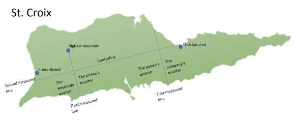
In the year 1742, the Landslisten was used for the first time to keep track of tax for properties.
   The Landlisten was made from the Mandtalslisten (Christiansen, 1982) The Landslisten
   contains information about: the name of the plant owners, the plant species (which was grown
   on the plantations, concerning whether it was sugar plantations, cotton plantations or small
   plots), and the length, width and number of the plantation, (which formed the basis for
   calculation of the land tax), Slaves including capable, manquerons and children. In the years
   1745 to 1747 the
   children were
   registered by sex, and
   in the years 1748 to
   1755 the children
   were registered by
   whether they were
   over or under an
   unknown age. The
   registration of slaves
   constituted the Kop
   tax. The Landslisten
   also contained the
   sum of how much tax
   the plantation owners
   must pay.
   (Rigsarkivet, n.d.)
   The Landslisterne did
   not appear until six
   years after the
   Mandtalslisten, which
   is due to the years
   where the plantation
   owners did not have to
   pay tax. The
   Landsliste formed the
   land register and were
   used until the West
   Indies-Guinea
   Company disbanded
   in 1754. A year later,
   the Danish
   government over the
   administration of the
   islands (Christiansen,     Figure 1 A section of the cadaster from St. Croix in 1763 p. 35 og 36, where it is written (1)
                              Østenden kvarteret Lit. A. (2) Transport, nr. 44 45 Michael Schay, Edmond Schays Fuka. (3)
   1982). The difference      Blanke familier, Mænd, Kvinder, Børn, Tjener. (4) Plantagenes størrelse, Længde, Brede,
   between the                Grund mål, Fod. (5) Grund skat, Rigsdaler. (6) Slaver, Capable, Manquerons, Børn mellem
   Mandtalslisten and the 12, 16 og børn under 12. (7) Kopskat, Rigsdaler. (Rigsarkivet, n.d.)

The Danish Slave Cadaster on St Croix, US Virgin Island (11146)
Camilla Knudsen, Terese Thode and Esben Munk Sørensen (Denmark)
FIG e-Working Week 2021
Smart Surveyors for Land and Water Management - Challenges in a New Reality
Virtually in the Netherlands, 21–25 June 2021
Landslisten was that blank was registered in the Mandtalslisten, which is not registred in the
   Landslisten, as it was used for tax and the Mandtalslisten was used so that the West Indies-
   Guinea Company could follow the development of colonization.
   In 1758 came a new list that registered taxes on St. Croix, named "the cadaster". At the time
   when the Vestindisk-Guinean Company owned St. Croix, the tax payment was registered in
   the Landslisten. When the Danish government took over the island, the tax payment was no
   longer registered in the Landslisten but in the cadaster. The cadastre was also used in
   Denmark at that time and therefore the cadastre was introduced on St. Croix. The difference
   between the Landslisten and the cadastre was that the Landslisten registers lengths and widths
   of the individual properties, where the cadastre registers plot sizes, so clarification is made of
   what kind of property of the object is being registered. The cadaster at St. Croix was used
   until two years before Denmark sold the West Indies to the United States in 1917. The
   cadaster has developed over the years and registered various conditions. In the period 1748-
   1853 the cadaster registered: Plant owners' names and families, blank (which was divided into
   four further categories), men, women, children and servants, land size, the sum of land tax,
   slaves comprising capable, manquerons, children between 12 and 16 and children under 12
   and the sum of Kop tax. (Rigsarkivet, n.d.)
   According to the original cadastre from St. Croix, the property tax was calculated based on
   the same conditions as it had been done in the Landslisten. Here it was further assessed
   whether slave children were under 12 years of age or between 12 and 16 years of age. If the
   slave children were between 12 and 16 years old, a half Rigsdaler was paid for them in tax,
   and if they were over 16 years old, they were considered an adult slave.
   In 1772, free slaves were registered in the cadaster, including whether they were born, died,
   and lived together. In 1793, adult slaves who could not work were registered, and slaves
   between the ages of 12 and 16 were called half-adults. (Rigsarkivet, n.d.) Through a royal
   decree, it was decided on March 16, 1792, that the transatlantic slave trade should not take
   place after 1803, and there should be more focus on the slaves reproducing themselves by
   giving birth to children. This did not result in slavery stopping. The slaves were still registered
   in the cadaster and included as a tax. (Brimnes, 2020)
   In 1840 there was a change in the registration procedure in the cadaster. Slaves were no
   longer written in the cadastre, but slaves were still registered by calling the slaves free and
   unfree.
   In 1847 it was decreed that by 1859 all newborn children of slaves should be born free. This
   created unrest among the slaves, and the following year, in 1848, Governor-General Peter
   Von Scholten announced that all slaves were free to avoid a slave revolt without the authority
   of the king. (Brimnes, 2020)
   Negotiations were held as to whether the plant owners should receive compensation for the
   release of the slaves, as the plant owners had lost part of their property and labor. This
   negotiation lasted for five years and ended in 1853, which is also the year where the slaves
   were no longer registered in the cadaster, which means there is a connection between the
   negotiation and the registration of slaves, as the year 1853 are five years after the slaves were
   released. It was decided that the plantation owners would receive $ 50 per. Slave, which was
   paid in government bonds as compensation. (Brimnes, 2020), (Rigsarkivet, n.d.)

The Danish Slave Cadaster on St Croix, US Virgin Island (11146)
Camilla Knudsen, Terese Thode and Esben Munk Sørensen (Denmark)
FIG e-Working Week 2021
Smart Surveyors for Land and Water Management - Challenges in a New Reality
Virtually in the Netherlands, 21–25 June 2021
The years when the cadastre has been valid on St. Croix was very different from year to year
   whether land tax was entered together with tax, or whether it was two lists that were
   registered separately but in the same book. However, both property tax and tax for the slaves
   were included in the cadaster. In 1805, the buildings value and tax assessment were registered
   in the cadaster. The building tax was calculated in measurements based on the acre. In 1865
   the cadaster was extended to also record taxes on leased land and buildings. (Rigsarkivet,
   n.d.)

       3. The shaping of the cadastre at St. Croix

   Frederik Moth was elected in 1733 by the management of the West Indies-Guinea Company
   as governor of St. Croix and it became his task to colonize the island (Brøndsted, 1966).
   The West Indies-Guinea Company had an interest in acquiring the products such as sugar and
   cotton that could be grown on St. Croix so that they could sell the goods and make a profit
   from them. The West Indies-Guinea Company would like to determine how St. Croix was to
   be colonized and therefore they sent letters to Frederik Moth with instructions on how to
   handle the colonization. The directors of the West Indies-Guinea Company sent instructions
   that St. Croix was to be divided into neighborhoods5 and the plantations were to be measured
   in certain sizes for the sake of the sugar mill's capacity. The governor of St. Thomas, Thomas
   Gardelin, mentions in a letter to the management that a reason for the survey is that with clear
   and visible property boundaries, disputes can be avoided. (Christiansen, 1982)
   The West Indies-Guinea Company had many plans for how St. Croix had to be surveyed even
   though they had no idea how big the island was or what it looked like. Among other things,
   they thought that the neighborhoods and plantations should be regular and that there could be
   600 plantations on St. Croix, but this assumption is not based on rational information.
   (Hopkins, 1992)
   Governor Frederik Moth had his own plan for how he would survey the island and he started
   by carving out and surveying a mainline. (Hopkins, 1987), (Christiansen, 1982)
   Next, he would survey the neighborhoods in squares and then survey 10-12 plantations in
   each neighborhood. When the lottery for the properties is over, the plantations will have to be
   divided into smaller properties. Frederik Moth estimated that there could be 2000 plantations
   on the island, respectively 1000 sugar plantations and 1000 cotton plantations. Although
   Frederik Moth wanted to follow the directors of the West Indies-Guinea Company's
   instructions, he criticized the method, realizing that it would take longer than intended to
   survey the island and form properties. Over time, the lines that have been carved would be
   overgrown by nature and therefore the surveyors would have to survey the lines again, which
   would provide double work. (Hopkins, 1987)

   5
    It was no stranger to the surveyors that St. Croix was to be surveyed in neighborhoods, as the idea probably
   originated in Copenhagen's neighborhoods. In 1633, Copenhagen was divided into eight districts and these have
   developed in step with the city's development. Today, the neighborhoods have been replaced by Ejerlav.
   (Københavns Stadsarkiv, n.d.)

The Danish Slave Cadaster on St Croix, US Virgin Island (11146)
Camilla Knudsen, Terese Thode and Esben Munk Sørensen (Denmark)
FIG e-Working Week 2021
Smart Surveyors for Land and Water Management - Challenges in a New Reality
Virtually in the Netherlands, 21–25 June 2021
The directors' instructions and Frederik Moth's expectations are not entirely the same, as they did not agree on how many plantations could be established on St. Croix, and at the same time, Frederik Moth was critical of the method to be used to survey the island. Despite the disagreements, Frederik Moth sails to St. Croix in 1734. Frederik Moth and the rest of the crew first arrive at Frederiksted, which lies at the western end of the island, which is a multifarious area with lots of fruit trees. Here he decided to build a plantation called La Grand from ancient ruins of former buildings left behind by the French. However, Frederiksted is very unprotected from pirates and other hijackers, and therefore Frederik Moth sought further inland to Christiansted, where a harbor could be built, which would be more protected. In Christiansted, there were also ruins of an old fort, which the French had also left behind, and it was around this fort that Frederik Moth wanted to build the town. Frederik Moth had plans for the city to be regular and look like Oslo. (Brøndsted, 1966) The survey of St. Croix then begins and in August 1735 Frederik Moth reports that a line has now been surveyed across the country from E.N.E to W.S.W, which is probably the centerline. There has also been surveyed a line N.N.W. to S.S.E. At the west end of the island there has also been surveyed a line from N.N.W. to S.S.E., which runs from the coast in the south to the highest mountain in the north, that is, a line lying between the West End neighborhood and the Prince's neighborhood. In addition, about 70 plantations have already been surveyed around the lines and Moth estimates that 200 more plantations can be surveyed quickly. The boundaries between the plantations and the lines were marked by the surveyors and their slaves carving out the vegetation, thus creating paths which are the mainstay of St. Croix road system. (Hopkins, 1987) The first lines surveyed are illustrated in Figure 2. Figure 2 The figure shows the first lines that were surveyed on St. Croix. The lines are shown in blue and Christianssted, the highest mountain, and the neighborhoods are indicated in the figure. The figure is for illustration only and therefore not measurable. Frederik Moth first surveyed the line that was placed between the Queen's and Company's quarters, which is placed N.N.W to S.S.E., and then he established the centerline. The centerline is placed across the island from Christiansted, which lies N.N.W to the coast in The Danish Slave Cadaster on St Croix, US Virgin Island (11146) Camilla Knudsen, Terese Thode and Esben Munk Sørensen (Denmark) FIG e-Working Week 2021 Smart Surveyors for Land and Water Management - Challenges in a New Reality Virtually in the Netherlands, 21–25 June 2021
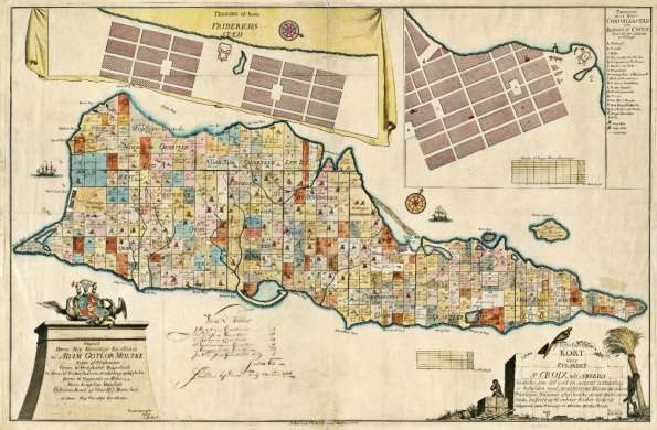
S.S.E, and served as a baseline for the other lines. The other lines surveyed from the
   centerline were to help survey the neighborhoods. (Hopkins, 1987)
   The surveys of the plantations often took longer than expected. So even though Frederik Moth
   reports that the surveyors were to map the last surveys in the East End in 1741, the
   neighborhood was not completed until 1743. (Hopkins, 1987)

   The survey of St. Croix took over 20 years (Hopkins, 1992). Figure 3 shows a map of St.
   Croix from 1766 and it shows that St. Croix was divided into 9 neighborhoods, where each
   plantation was assigned a number so that the plantation could be known by neighborhood and
   number. Also, it is seen that the plantation La Grand, owned by the West Indies-Guinea
   Company, was established at Frederiksted. In the Northside quarter in 1766 there were still
   some properties that were not included in the cadaster. In the Ost Ende neighborhood, the
   grounds are not regular like the other neighborhoods. This is because cotton was primarily
   grown in this neighborhood, and that there was a demand here that the plantations should be
   smaller (Christiansen, 1982). Even though the survey was a long time in the making, the
   format of the cadaster was fulfilled in 1766 with the directors' instructions that St. Croix were
   to be surveyed in neighborhoods with regular plantations.

   Figure 3 This figure shows the map Tilforladelig kort over eylandet St. Croix udi America saaledes som det ved en acurat
   udmaaling er besunden med qvarterernes navne og enhver plantagies nummer efter hvilke de udi matriculen findes indförte
   og til enhver kiöber cederet beliggende paa 17 grader 38 minuter norder brede. Drawed by I. M. Beck and O. H. De Lode. in
   1766. (Library of Congress, n.d.)

The Danish Slave Cadaster on St Croix, US Virgin Island (11146)
Camilla Knudsen, Terese Thode and Esben Munk Sørensen (Denmark)
FIG e-Working Week 2021
Smart Surveyors for Land and Water Management - Challenges in a New Reality
Virtually in the Netherlands, 21–25 June 2021
4. The imprint of the slave cadaster during the slave era in the United States

   The survey method which has been used on St. Croix, has not been seen used on the other
   islands in the Danish West Indies, which means it is special for the island (Hornby, 1980).
   The survey method that is used on St. Croix , which is based on baselines that is used to
   survey properties and form the property system, is used later in 1784 on the American
   mainland.
   In 1776, the United
   States signed the
   Declaration of
   Independence, which
   meant that the
   colonies along the
   east coast of the
   United States were
   given the right to
   survey the
   uncolonized land to
   the northwest. The
                           Figure 4 Map illustrating geographers’ line and the lines that were measured to form the first
   method that should      the seven ranges. East of the Ohio River, the land was already colonized by the colonies and
   be used where up for with the Declaration of Independence, it was now a matter of getting colonized west of the
   debate. In 1784,        Ohio River. (Kain & Baigent, 1992) This figure is developed with inspiration from (Kain &
                           Baigent, 1992).
   Thomas Jefferson
   and Hugh
   Williamson got the idea that the uncolonized land should be divided into hundreds of small
   plots, which all should have the same measurement. The format of properties should be based
   on a baseline that runs from west to east, also called the geographers' line. From geographers’
   line, perpendicular lines were to be measured, which would form areas called ranges. In these
   ranges, the properties were to be surveyed. Geographers' line was measured in 1785, and then
   the guidelines where measured. After two years the surveyors had measured both the
   guidelines and the properties in four ranges, cf. Figure 4. (Kain & Baigent, 1992)
   In the United States, the Congress sought a surveying method, so that it would no longer be
   possible for pioneers to choose only the good land and exclude the bad, and they would like
   more peace so that disagreements over property boundaries would not be created, and that
   was exactly what this survey method could. These justifications are also some of the reasons
   why the method is a basis for the survey at St. Croix. (Kain & Baigent, 1992)
   This survey method has been the starting point for a new regular real estate system in the
   USA. (Kain & Baigent, 1992) On St. Croix, a similar survey method has colonized the island
   in a rectangular structure and created rectangular property boundaries like in the USA. The
   survey method in the USA is, as mentioned, developed by Thomas Jefferson and Hugh

The Danish Slave Cadaster on St Croix, US Virgin Island (11146)
Camilla Knudsen, Terese Thode and Esben Munk Sørensen (Denmark)
FIG e-Working Week 2021
Smart Surveyors for Land and Water Management - Challenges in a New Reality
Virtually in the Netherlands, 21–25 June 2021
Williamson, but it was not until 1784 that they developed the method, whereas the similar
survey method at St. Croix was used in 1733.
A question can therefore be asked as to whether the surveying method was developed by
Thomas Jefferson and Hugh Williamson or whether it is Danish surveyors, the West Indies-
Guinea company, and Frederik Moth who have been the first with the idea of this method.
This deserves to be investigated in new research work.
5. The significance of the slave cadaster for the address system
Previously, the address system was based on the name and a number of the property. The
number is based on the original numbers that each plantation received when St. Croix was
colonized in 1733. After the establishment of the planters in the 18th century, many new
properties have been created, and the new properties have been given new numbers, which
were the next number in a row. Therefore, there was no logical number system, but random
how the numbers are distributed geographically on each road. (Lieutenant Governor of the
United States Virgin Islands, 2019)
The slave register has served as a starting point for the address system that has been at St.
Croix before 2013. In doing so, the slave register has had a major impact on how new
properties were identified.
6. Timeline
This chapter is a summary of the previous chapters in the form of a timeline of St. Croix
history, seen in Figure 5, where all the years of events are set up in chronological order. On
the timeline under the West Indies, there is a single text in red, which is because this incident
has taken place in the United States but relates to the survey method at St. Croix.
The Danish Slave Cadaster on St Croix, US Virgin Island (11146)
Camilla Knudsen, Terese Thode and Esben Munk Sørensen (Denmark)
FIG e-Working Week 2021
Smart Surveyors for Land and Water Management - Challenges in a New Reality
Virtually in the Netherlands, 21–25 June 2021Figure 5 Timeline of the events highlighted in the previous chapters. The Danish Slave Cadaster on St Croix, US Virgin Island (11146) Camilla Knudsen, Terese Thode and Esben Munk Sørensen (Denmark) FIG e-Working Week 2021 Smart Surveyors for Land and Water Management - Challenges in a New Reality Virtually in the Netherlands, 21–25 June 2021
7. Conclusion

   In a cadastral narrative and in the way the surveyor's profession is told, nothing has ever been
   written about the slave cadaster on St. Croix, not even in the Danish textbooks on cadastral
   registration. This role of the cadastre has been known to the historians who has written about
   the slave conditions at St. Croix, but the slaves and the cadastre have never been linked in the
   surveyor's profession. Through the study of the cadaster at St. Croix, a new understanding has
   been created and it can be concluded that the purpose of the cadastre is no different at St.
   Croix in relation to the cadastre known in Denmark. The purpose of the cadaster is to tax
   property, which has been the purpose both in Denmark and on St. Croix. But the concept of
   property for the two places is not the same. In Denmark, properties, land and buildings were
   registered, and on St. Croix they registered properties and land, but also the value of slaves as
   labor on the individual properties. Between 1742 and 1853, the Danes, therefore, saw slaves
   as property, as slaves were bought as labor belonging to the property, and therefore slaves
   were registered in the cadaster. It is therefore the property concept that is different from
   Denmark to St. Croix and not the purpose of the cadastre.

   When St. Croix had to be surveyed, the island was impassable and uninhabited except for a
   few Englishmen. Also, the climate, nature, and landscape were different from Denmark to St.
   Croix. It was therefore not easy for the surveyors to survey St. Croix despite the very detailed
   instructions sent from Copenhagen by the directors of the West Indies-Guinea Company. The
   directors of the West Indies-Guinea Company were equally unaware of how St. Croix terrain
   were as they bought the island in addition to a few descriptions. As the travel time from one
   place in the world to another was long in the 18th century, none of the directors knew
   anything about the landscape other than the landscape in the Nordic countries, and therefore
   they didn’t know that it wasn’t comparable to the landscape on St. Croix. The planning of
   how St. Croix had to be surveyed was, therefore, made based on the narrow knowledge they
   had, which resulted in the directors of the West Indies-Guinea Company sending instructions
   that were difficult and at some points impossible to oblige. This meant that Governor Frederik
   Moth had to think of other methods in the survey of St. Croix. As was written, Denmark was
   measured based on existing boundaries and roads, where St. Croix was measured from the
   centerline that was placed through the island, where nine neighborhoods were to be surveyed
   from. Subsequently, each neighborhood was measured in squares that were to contain 10 to
   12 plantations that were equal in size. Furthermore, it can be seen from the time frame that it
   has been more complicated to survey St. Croix, as it took 20 years to survey the island.

   The surveying method, that is used on St. Croix, is very comparable to the method used to
   survey the mainland of the United States as the methods both take place in a baseline and
   some guidelines who forms the property system. The interesting thing about this is that it is
   claimed that Thomas Jefferson and Hugh Williamson were the first to come up with the idea
   of surveying land using this method. But the mainland of the United States was first surveyed
   in 1785 when St. Croix was measured by a comparable method 50 years earlier. It can
   therefore be hypothesized that Thomas Jefferson and Hugh Williamson were not the first to

The Danish Slave Cadaster on St Croix, US Virgin Island (11146)
Camilla Knudsen, Terese Thode and Esben Munk Sørensen (Denmark)
FIG e-Working Week 2021
Smart Surveyors for Land and Water Management - Challenges in a New Reality
Virtually in the Netherlands, 21–25 June 2021
come up with the idea of surveying land based on a baseline, but that Danish surveyors were
   the first to devise and carry out this method on St. Croix.

   On St. Croix there is still traces of the Danish slave cadaster. It is still possible to see a
   connection from when Danish surveyors surveyed and registered St. Croix to how St. Croix
   looks today. Since the first properties were surveyed, the properties have been merged and
   divided many times, but it is still possible to see that the old cadastral map forms the basis for
   how the properties, roads, and cities are today. Figure 6 shows a contemporary orthophoto
   compared to a map from 1754. The map shows that many of the paths that were carved and
   surveyed between the plantations lay in the same place as today's roads. The centerline, which
   was carved when St. Croix was surveyed is an existing road today where the street name,
   Centerline Road, is also named after the centerline. It can thus be seen that the slave cadaster
   has been the foundation of today's infrastructure. Likewise, it is also only in recent times that
   the address system was redesigned so that it is no longer based on the slave register, even
   though it created many problems. The address system may have created consequences for the
   residents of St. Croix.

   Figure 6 The figure shows a comparison between a map drawn by I. M. Beck and O. H. De Lode in 1754 and a map of St.
   Croix from Google Maps (Library of Congress, out) and (Google, 2020) The white lines illustrate roads from Google Maps
   that is the contemporary roads, and the black lines show where the plantations went in 1754. The dotted red line is the
   centerline from 1754. Centerline Road is also shown in the figure.

   The slave register at St. Croix is an untold story that may not be remembered. But it is not a
   part of the history that we can omit if the whole context is to be told, neither as a historian, the
   cadastral narrative nor within the Danish land surveyor profession. The Danish surveyors has
   created a property register that registered people as property, but they have also surveyed St.

The Danish Slave Cadaster on St Croix, US Virgin Island (11146)
Camilla Knudsen, Terese Thode and Esben Munk Sørensen (Denmark)
FIG e-Working Week 2021
Smart Surveyors for Land and Water Management - Challenges in a New Reality
Virtually in the Netherlands, 21–25 June 2021
Croix with a surveying method who has since been used elsewhere in the world. The purpose
   of the property registration was no different on St. Croix compared to in Denmark, but the
   concept of property was different.

     8.
   REFERENCES

   Brimnes, N. (2012). Vestindisk-Guineisk Kompagni, 1671-1754. Retrieved from
           https://danmarkshistorien.dk/leksikon-og-kilder/vis/materiale/vestindisk-guineisk-
           kompagni/
   Brimnes, N. (2020). De Vestindiske Øer, 1672-1917. Retrieved from
           https://danmarkshistorien.dk/leksikon-og-kilder/vis/materiale/de-vestindiske-oeer-
           dansk-vestindien/
   Bro-Jørgensen, J. O. (1953). Dansk Vestindien indtil 1755. P. 135. Samfundslitteratur.
   Brøndsted, J. (1966). Vore gamle tropekolonier. P. 244-245. Fremad.
   Christiansen, H. B. (1982). Det Vestindisk-guineiske Kompagnis kolonisation af St. Croix
           1732 - 51. P. 20-78. Samfundslitteratur.
   Hopkins, D. (1987). The Danish cadastral survey of St. Croix, 1733-1754. P. 96-98, 246, 304-
           311. B. A., Tulane University of Louisiana.
   Hopkins, D. (1992). An early map and the cadastral survey of St. Croix, Danish West
           Indies/A cartographic cul-de-sac. Cartographica, pp. 1-19.
   Hornby, O. (1980). Kolonierne i Vestindien. P. 98. Politikens forlag.
   Kain, R. J., & Baigent, E. (1992). The Cadastral map in the Service of the State. P.289-292.
           The University of Chicago.
   Københavns Stadsarkiv. (n.d.). Københavns kvarterer. Retrieved from
           https://kbharkiv.dk/brug-samlingerne/vejledninger/koebenhavns-kvarterer/
   Library of Congress. (n.d.). Tilforladelig kort over eylandet St. Croix udi America saaledes
           som det ved en acurat udmaaling er besunden med qvarterernes navne og enhver
           plantagies nummer efter hvilke de udi matriculen findes indförte og til enhver kiöber
           cederet beliggende paa 17 gr. Retrieved from
           https://www.loc.gov/resource/g5012s.ct000319/?r=0.005,0.015,1.055,0.617,0
   Lieutenant Governor of the United States Virgin Islands. (2013). U.S Virgin Islands Street
           Addressing Initiative. Retrieved from
           https://docs.google.com/viewer?a=v&pid=sites&srcid=ZGVmYXVsdGRvbWFpbnx1
           c3ZpYWRkcmVzc2luZ2luaXRpYXRpdmV8Z3g6MzIzMmYzNjI4NjI2Zjc2Yw
   Lieutenant Governor of the United States Virgin Islands. (2019). Street Addressing Initiative.
           Retrieved from https://ltg.gov.vi/departments/street-addressing-initiative/
   Rigsarkivet. (n.d.). Christian 5.s matrikel, Rentekammeret: Christian 5.s matrikel.
           Matrikelbøger (1688 - 1691). Retrieved from https://www.sa.dk/ao-
           soegesider/da/other/index-creator/43/6754/21658914
   Rigsarkivet. (n.d.). Matrikler. Retrieved from https://www.sa.dk/ao-soegesider/da/other/other-
           collection/76

The Danish Slave Cadaster on St Croix, US Virgin Island (11146)
Camilla Knudsen, Terese Thode and Esben Munk Sørensen (Denmark)
FIG e-Working Week 2021
Smart Surveyors for Land and Water Management - Challenges in a New Reality
Virtually in the Netherlands, 21–25 June 2021
Rigsarkivet. (n.d.). Reviderede Regnskaber, Vestindiske Regnskaber. Retrieved from
https://www.sa.dk/ao-soegesider/da/billedviser?epid=17226869#206936,39298935
Rigsarkivet. (n.d.). Vestindisk-Guineisk Kompagni, Bogholderen på St. Croix. Retrieved from
https://www.sa.dk/ao-soegesider/da/billedviser?epid=17226850#206886,39286096
Rigsarkivet. (n.d.). Vestindisk-Guineisk Kompagni, Bogholderen på St. Croix. Retrieved from
https://www.sa.dk/ao-soegesider/da/billedviser?epid=17226860#206891,39288197
Sundstrøm, M. (Director). (2017). Historien om Danmark: Enevælde og oplysningstid
[Motion Picture].
BIOGRAPHICAL NOTES
CONTACTS
Camilla Knudsen
B.Sc.(Surveying, Mapping and Cadastral Science), Master Student.
Aalborg University
Toldbodgade 30, 2., lejl. 1
9000 Aalborg
Denmark
+45 2212 7633
Email: cknud16@student.aau.dk
Terese Thode
B.Sc.(Surveying, Mapping and Cadastral Science), Master Student.
Aalborg University
Toldbodgade 30, 6., lejl. 8
9000 Aalborg
Denmark
+45 4072 7875
Email: tthode15@student.aau.dk
Esben Munk Sørensen
Chartered Surveyor, M.Sc. PhD. Professor (GI and Land Management).
Aalborg University
9000 Aalborg
Denmark
+45 9940 8347
Email: ems@plan.aau.dk
The Danish Slave Cadaster on St Croix, US Virgin Island (11146)
Camilla Knudsen, Terese Thode and Esben Munk Sørensen (Denmark)
FIG e-Working Week 2021
Smart Surveyors for Land and Water Management - Challenges in a New Reality
Virtually in the Netherlands, 21–25 June 2021You can also read