The development of the - E3S Web of Conferences
←
→
Page content transcription
If your browser does not render page correctly, please read the page content below
E3S Web of Conferences 168, 00010 (2020)                                 https://doi.org/10.1051/e3sconf/202016800010
RMGET 2020

       Current trends in the development of
       automation    surveying support in the
       construction of subways
       Abduboki Khakimov 1,*, Gullola Kutumova1, and Zamira Mirzaeva2
       1
        Tashkent State Technical University, 100095, Tashkent, University Str., 2, Republic of Uzbekistan
       2
        Tashkent Institute of Engineers of Railway transport, 100067, Tashkent, Adilkhodjaev Str., 1,
       Republic of Uzbekistan

                     Abstract: The article discusses the basic principles and conditions for the
                     use of the latest underground navigation system. An example is given of
                     the second new Yunusabad line of the Tashkent Subway using the shield
                     method. For the first time in the Republic of Uzbekistan, in the
                     construction of the Tashkent metro stations by underground, the Tunneling
                     Mechanized Complex (TMC) was used - a movable prefabricated metal
                     structure manufactured in Germany by the company HERRENKNECHT,
                     which is the leading company in the world and produces machines for the
                     construction of tunnels of any diameter in the range from 0.10 to 19 m in
                     any engineering-geological conditions. The disadvantages and advantages
                     of the underground navigation system are indicated; conclusions are drawn
                     about the prospects for its application. The patterns of development of
                     technical aspects of the automation of surveying concerning general
                     historical trends are examined.

       1 Introduction. The development of the surveying support system in
       the construction of the Subway
       One of the most important directions in the development of the mine surveying support
       system is the creation of a technical base that would make it possible to fully utilize the
       capabilities of electron-optical and computer technology, economic and mathematical
       methods, and information technology to increase the efficiency of accounting and control of
       mining operations and the validity of decisions made. An integrated approach to solving the
       problems of surveying and the use of accurate quantitative methods and computer
       technology in the production of surveying operations are the main components of the
       process of automating surveying support for mining and create entirely new conditions for
       its implementation [4]. Automation in surveying is not only an instrument of self-
       improvement, but also raises all mining production to a higher level. Many years of
       experience in introducing and operating new surveying technologies using electron-optical
       and gyroscopic systems gives enough reason to conclude that their use, especially when
       working in hard-to-reach mountain regions of Uzbekistan, in urban conditions, is not only

       *Corresponding author: alyanizamova@umal.uz

© The Authors, published by EDP Sciences. This is an open access article distributed under the terms of the Creative Commons
Attribution License 4.0 (http://creativecommons.org/licenses/by/4.0/).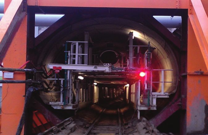
E3S Web of Conferences 168, 00010 (2020)                       https://doi.org/10.1051/e3sconf/202016800010
RMGET 2020

      economically justified, but often it is the only a possible mean of quick execution of work
      with the least expenditure of physical labor [8]. During design and construction, the
      structure of the massif, the physicomechanical properties of rocks, their change in time, the
      seismicity of the region, maximum loads, etc., are taken into account. Tunnels are an
      essential link in the construction of underground engineering structures related to the
      growth and development of the national economy. In this regard, surveying works are
      widely used in tunneling. Geodetic surveying work is a responsible process at all stages of
      the construction of subways [10]. The quality, timing and operational effect of the use of
      facilities under construction largely depend on the timely and high-quality implementation
      of geodetic-surveying work. Research in this area helps to achieve higher accuracy, both in
      observation and in calculations. New developments allow us to automate the work in the
      tunnel and contribute to reducing the time spent on measuring angles and distances [5].
      During the construction of the subway tunnels, after the installation of the tunnel rings,
      various kinds of deformation arise. To ensure a trouble-free operation of the subway, it is
      necessary to conduct constant and high-precision geodetic observations of the Development
      of deformations of underground metro structures. A significant point for ensuring
      integrated safety in mining is to control the stability of the earth's surface, buildings, and
      structures located in areas affected by mine workings, sides of quarries, and predicting their
      behavior. Today, deformational monitoring of the state of natural objects and artificial
      structures is a necessity and an integral part of an integrated security system [6].
          The level of modern equipment, the latest communication tools, powerful computing
      systems, and software products allow to design and create Automated Deformation
      Monitoring Systems (ADMS). Depending on the construction scheme adopted in severe
      geological conditions, the excavation of the workings of a broadcross-section can be carried
      out by continuous slaughter or in parts when mining works are carried out at different
      horizons. The task of the surveying service, in this case, is to ensure the exact closure of the
      lining elements, erected simultaneously in different parts of the structure. Therefore, the task
      of directions during the excavation of mine workings in the horizontal and vertical planes is
      combined with the simultaneous execution of a set of alignment works both during the hole
      and the erection of the lining. Besides, when cutting underground chambers of broad cross-
      section, there is also a need for monitoring the stability of temporary filling and subsurface
      structures. The highest requirements for the accuracy of the alignment work are imposed
      during the installation of sophisticated underground energy, transport, and other equipment.
      Modern high-speed mining methods for underground mining require the use of new, more
      advanced methods of surveying control, providing high performance and accuracy of
      measurements. On extensive use of modern laser mine-surveying instruments at all stages of
      civil engineering and surveying so that because giving the necessary support to install and
      installation of process equipment in current conditions is possible only through the use of
      laser methods. Based on the preceding, it can be concluded that improving the methods of
      surveying in underground construction using laser devices is an urgent task [9].

      2 Methods

      2.1 Modern methods and means of mine surveying during the construction of
      a new line "Tashkent subway" using the shield method
     In the design, construction, and operation of tunnels, it is necessary to solve complex
     scientific, engineering, and environmental problems using the latest achievements of
     science and technology. The art of modern tunneling is precisely to use and correctly
     combine the necessary developments that exist in the world. In engineering works related to

                                                    2
E3S Web of Conferences 168, 00010 (2020) https://doi.org/10.1051/e3sconf/202016800010
RMGET 2020
the installation and construction of tunnels, new technologies and materials are widely
used. The use of new high-performance equipment allows them to be performed in a shorter
period, which helps to reduce the time of commissioning of facilities. The most illustrative
example of the Development of innovative technologies is the use of advanced high-
performance mining equipment. For the first time in the Republic of Uzbekistan in the
construction of the subway stations of the Tashkent underground methods applied
Tunneling Mechanized Complex (TMC) - movement prefabricated metal structure, made in
Germany, "Companies HERRENKNECHT" AG. Concern "HERRENKNECHT" AG
recognized world leader in the field of mechanized tunneling equipment. This is the
world's leading company that produces machines for the construction of tunnels of any
diameter in the range from 0.10 to 19 m. Subway builders had at their disposal a pickaxe, a
shovel, and a trolley. Today, builders have the most advanced technology in their
arsenal. Tunnels are laid by individual machines - tunneling mechanized complexes or
shields. Tunnel construction has always been an extremely complex engineering challenge.
Hard rocky soils, soft clays, and loose sands, aquifers that can flood the space underground
in a matter of minutes, are waiting for the walkers. Solid not only dig underground passage
but also reinforce it, leaving a ready-tunnel. The iron concrete ring formed of five main RC
tubings, each weighing 3200 kg and locking tubing 500 kg, the weight of the whole
ring 16500 kg. Forward movement of the machine provides a tunneling machine overcomes
10 to 12 meters per day in the construction of the tunnel. Pass 250-300 meters per month is
considered a good indicator of the builders. After the underground passage is entirely ready,
the builders lay the rails and bring engineering networks. The usual distance between
stations is 2-2.5 km. A sabway train travels this distance in three minutes (Fig.1).
Fig. 1. The head part Knife, the support ring, and the tail of the shield.
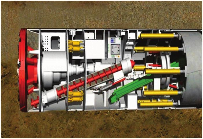
Fig. 2. Airlock shield chamber (Tashkent-2018).
3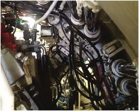
E3S Web of Conferences 168, 00010 (2020)                             https://doi.org/10.1051/e3sconf/202016800010
RMGET 2020

          The path underground is laid by the most accurate navigation electronics; with its help,
      the shield surveyor checks the designcoordinates of the track in plan and profile. After the
      tunnel is laid, the tunneling equipment will be used when putting other under ground lines
      shields with soil loadmainly used for the consistency of the soil from porridge to soft. The
      breed itself, developed with the help of a working body, acts as a medium for the cargo.
      Ground with the addition of conditioning agents is converted into "porridge" and is used to
      maintain the face breast. On the screw, reaching the bottomhole chamber, the soil is fed in
      the direction from the chest of the face. From the auger, the developed rock gets to the
      conveyor belt, with the help of which it moves to the loading station of the transport
      trolleys. The installation of the tunnel reinforced concrete lining is carried out using the
      block stacker in the sequence, the control panel of the block stacker switches to the "ring
      mounting" operating mode, after which it is allowed to control the driving jacks when using
      the control unit of the block layer. Blocks are transported to the block layer utilizing a block
      storage unit [3] (Fig. 3-4).

      Fig. 3. The tail of the technological shield trolley (Tashkent-2018).

      Fig. 4. Finished high-quality tunnel lining (Tashkent-2018).
           The injection of grouting mortar into the construction gap between the soil and the
      lining of the tunnel ensures the geometric immutability of the coating, the joint work of the
      filling with the surrounding soil, prevents the settlement of the surface during sinking,
      ensures the safety of the lining and increased water resistance for the period of operation of
      the tunnel [1].
           The solution to the issues of intensive Development of the subway is impossible without
      a sharp increase in labor productivity, strengthening engineering preparation of production,

                                                        4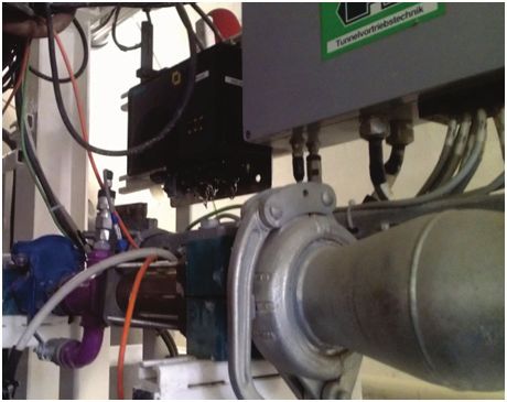
E3S Web of Conferences 168, 00010 (2020)                      https://doi.org/10.1051/e3sconf/202016800010
RMGET 2020

      and, most importantly, without accelerating the scientific and technological progress of
      industries of all types of work. Modern information technologies, high-tech equipment, and
      ambitious projects, which are often on the verge of possible, all this leads to the appearance
      of new developments that make the construction of tunnels safer, more economical, and
      more diverse.

      2.2 Underground laser navigation system "SLS – SL" of the German
      company "VMT" GmbH for (TMC) "HERRENKNECHT" AG
     The problem of determining the location under the ground appeared almost
     simultaneously with the idea of developing underground space. At present, when building
     tunnels for various purposes, automatic navigation systems have become
     widespread. They allow to determine the spatial position of the tunneling complex
     in real-time, which significantly increases the speed, accuracy, and quality of the
     structure under construction [1]. When constructing tunnels, it is essential all the time
     to have information on the position of the tunnel complex relative to a given tunnel
     path. Only by continually monitoring the situation of the (TMC) it is possible
     to consistently and continuously correct unwanted displacements of the tunnel shield
     and thereby prevent deviations of the protection from the projected axis of the tunnel.
     Many differences affect the differences from a given path: for example, soil structure
     (rocky, sandy, clay, etc.). In soft rocks, a tunneling complex weighing hundreds of
     tons does not react at all like in hard stones [4]. "The VMT" GmbH - surveyor-
     geodetic service for the Development of an underground navigation system for tunneling,
     is a company that started in April 1994. The SLS - SL navigation system is designed
     for tunnel shields with tubing lining, the principle of the system: when the Tunneling
     complex is moving, the current position of the target is continuously read from
     the system automatic tachometer, and the exact location of the machine is displayed
     through its ratio with the projected axis of the tunnel. The next step in the construction
     of tunnels with tubing lining is the construction of the tubing ring itself in the tail
     of (TMC). The choice of the most suitable ring is of great importance, which determines
     the quality of the entire tunnel structure in the future. If the machine deviates from
     the design axis, the program automatically calculates the corresponding correction curve,
     which ensures the removal of the device to the planned design axis. In addition
     to calculating the position of the rings and the order of their construction, as the work
     progresses, for the development of a tunnel with tubing lining to ensure high-quality
     construction and guarantee its safety [2].
         The navigation system SLS ( Space Launch System ) of VMT, which transmits all the
     information needed to move the (TMC) along a given track at high speed, was developed
     specifically for this purpose. Besides, she issues full documentation describing the
     movement of the shield and a lot of additional information, for example:
         - calculation and depiction of the position of (TMC) in graphic and digital form;
         - calculation and image of the installed rings, showing the location of the collar after its
     installation;
         - prediction and model of (TMC) displacement trends (shield diagram);
         - calculation of a correction curve tangentially leading (TMC) back to a given path;
         - preliminary calculation of the tubing rings to be installed in the future (based on the
     route and the correction curve);
         - management of system elements from an industrial computer;
         - full documentation on the progress of the shield (database, log files, etc.)
         The navigation system SLS - SL includes: a total station with a built in laser (Fig. 5);
     radio modem No.1 (mobile) (Fig. 5); active Laser Target (ELS) (Fig. 7); radiomodem No. 2

                                                   5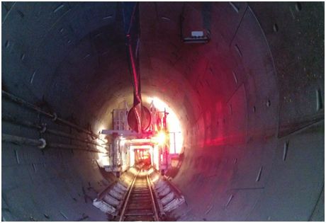
E3S Web of Conferences 168, 00010 (2020)                                https://doi.org/10.1051/e3sconf/202016800010
RMGET 2020

     (motionless) (Fig. 8); Central Radio Modem (switch) (Fig. 9); industrial computer
     with Tunis software (Fig. 10); prism reflector (Fig. 6); power Cables.

      Fig. 5. Half-robot laser total station and Radio modem (mobile). (Tashkent-2018).

      Fig.6. Prism - a reflector on the console. (Tashkent-2018).

      Fig. 7. Active laser target inside the shield. (Tashkent-2018).

                                                         6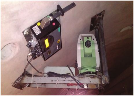
E3S Web of Conferences 168, 00010 (2020) https://doi.org/10.1051/e3sconf/202016800010
RMGET 2020
Fig. 8. Radio modem (fixed). (Tashkent-2018).
Fig. 9. Central Radio Modem (Switch). (Tashkent-2018).
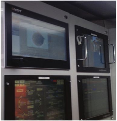
Fig. 10. Industrial computer "VMT" (Tashkent-2018).
7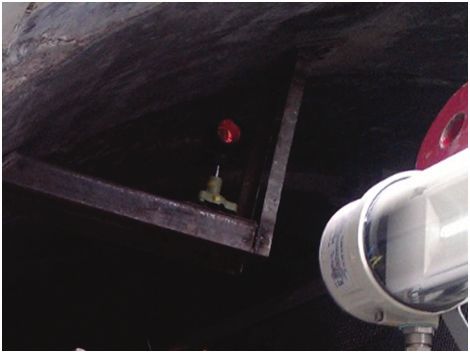
E3S Web of Conferences 168, 00010 (2020)                        https://doi.org/10.1051/e3sconf/202016800010
RMGET 2020

          After orienting the laser total station relative to the backsight point (prism reflector), the
      entire station is automatically aimed at the laser target mounted inside the shield, the signals
      from the target are transmitted through the laser station through the channels of the Radio
      modem to an industrial computer in the control panel, the total laser station measures
      horizontal and horizontal angles at the points also the distance, there the data of these
      measurements are presented on the monitor in graphic and digital format. Tunis
      (Tunnel and Under ground integrated Software) is an integrated software platform for
      preparing and analyzing data in tunnel and subway construction projects [2].
          The introduction of an underground navigation system into the surveying practice was
      an essential for the further development of the techniques and methods of underground
      surveys. It is impossible to judge the accuracy of measuring angles and the distance of
      underground surveying points by the result of the navigation system of the tunneling
      mechanized complex. Mine surveying should be carried out in such a way that reliable
      surveying and individual surveying measurements are carried out the control.

      3 Conclusions
      The introduction of an underground navigation system into the surveying practice is of
      great importance for the development of underground surveying methods. The use of the
      latest underground navigation system in the construction of the Tashkent Subway in the
      field of new electron-optical measuring instruments qualitatively changed the speed of
      surveying operations, and increased the accuracy of measurements.
          The advantage of the underground system SLS-SL of VMT GmbH provides real-time
      information on the position of the tunnel complex, which significantly increases the speed,
      accuracy and quality of the structure under construction.

      References
     1. Instructions for geodetic and surveying work in the construction of Transport tunnels,
         UBC 160-69
     2. Guide to the activities of the company " VMT " GmbH and the underground navigation
         system). Retrieved from: https://cyberleninka.ru/article/n/o-deyatelnosti-firmy-vmt-
         gmbh/viewer
     3. Materials of publications and information retrieved from the Web site of the
         "HERRENKNECHT" AG Company. Retrieved from: https://www.herrenknecht.com.
     4. Kartosia, B.A., Fedunets, B.I., Shuplik, M.N., Malyshev, Y.N. et al (2001). Mine and
         Underground Construction: 2nd ed. in 2 vol. Moscow: Academy of Home Sciences
     5. Popov, V.N., Bukrinsky, V.A. (2004). Geodesy and Mine Surveying. Moscow:
         Publishing House of Moscow State University
     6. Pevzner, M.E., Popov, V.N., Bukrinsky, V.A. (2003). Mine surveying. Moscow:
         Publishing House of Moscow State University
     7. Evstafiev, O.V., Yaschenko, A.I. (2010). Problems of installation and safety of
         equipment of automated monitoring systems, Geoprofi, 2
     8. Instructions for the production of surveying operations. (2004). RD 07-603-03
     9. Geodetic instruments and equipment. (2003). Catalog: Moscow: NPP
     10. Eremenko, E.V. (2012). The formation of cargo flows, overburden taking into account
         the location. human-made resource career. Coal, 9. Moscow: Mountain Book

                                                     8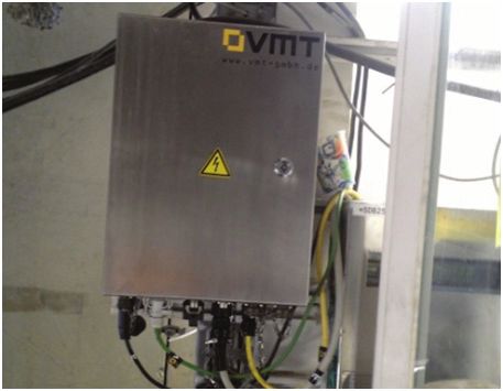
You can also read