The Five Essentials of Weather Optimized Routing for Marine Vessels - DTN
←
→
Page content transcription
If your browser does not render page correctly, please read the page content below
The Five Essentials of
Weather Optimized
Routing for Marine Vessels

 www.dtn.com • 844.994.2278
 © 2020 DTN, LLC, all rights reserved. “DTN” and the degree symbol
 logo are trademarks of DTN, LLC.
What is Weather Optimized Routing?
Plotting a course from Gulf of Mexico [A] to Port of London [B] is not so hard. But getting
from A to B, while managing costs, keeping fuel consumption down, and maintaining safety is
more of a challenge.

Weather optimized routing provides a solution. It enables vessels to take the most efficient
route, by combining the latest weather data, with information on sea conditions and the
ship’s profile. It’s not necessarily the shortest route; it’s the most effective way for a vessel to
meet its key performance indicators. In this guide, we explore the five essentials of weather
optimized routing, and clear business benefits.

Understanding the Five Essentials of
Weather Optimized Routing
Weather optimized routing is point-to-point safe route planning. It includes speed and heading
recommendations, taking into account impacts from environmental forces on a vessel’s
performance. The essential essentials for weather optimized routing are:
• Weather Data
• Vessel Profiles
• Unique Routing Algorithm
• Weather Optimized Route Network
• Master Mariners

Combining the essentials makes it possible to offer a genuinely optimized service — a real
strategy for success.
#1 Weather Data
High-resolution data is better for
data analysis, but what is weather
resolution, and why is it important?

This example shows a grid over Great
Britain. Pay particular attention to
the English Channel. Each box’s color
designates whether it is land or water.
If the box contains 50% or more land,
it’s green. If it’s 50% or more water,
it will be blue. The high-resolution on
the right provides almost twice the
boxes offered by the low-resolution

Take away the land from under the grid, and what is left doesn’t
resemble the British Isles anymore. However, with the higher
resolution on the right, the Channel is still visible. Dividing the cells
again brings further clarity to the features.

This example shows the differences in model resolution. The higher the
resolution, the better the model can resolve geographic and weather features.
If the model can’t even see the English Channel on the low-resolution view,
how will it predict the weather accurately?
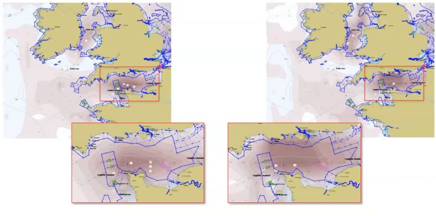
Impact of resolution on a
real forecast
Here is a prediction of currents at the same          The different resolutions could influence
moment in time, using both a high- and low-           decisions on whether to depart earlier or
resolution model for the same area. Again,            later in the voyage plan. Alternatively, it
take note of the English Channel. The low             might alter the route chosen through the
resolution on the left has a limited area of          channel. Either way, speed calculations and
maximum current. The high resolution on               vessel performance through this area will be
the right has a better-resolved channel and           affected by this currents difference by using
shows the stronger currents throughout the            the higher resolution forecast model.
entire channel.

#2 Vessel Profiles
The next essential weather optimized routing is vessel profiles. A ship model depends on
many items, including hull design, propeller, and engine.

For weather optimized routing, what is important is how the vessel model responds to the
environment. Its profile includes waves, wind, and swell. It also considers the angle of the
impact versus vessel heading, which is essential for resistance calculations.

DTN has a strong partnership with Marin, who provides a library of precision profiles that
are used for route calculations. These profiles are selectable throughout the DTN product
suite. Additionally, profiles can be customized for vessel draft, beam, and LPP, as well as for
speed and fuel curves.

#3 Unique Routing Algorithm
The DTN unique routing algorithm is the glue that Then comes the vessel characteristics, including
holds all the essentials together. It must be fast vessel model and profile, laden versus ballast
and efficient to return a prompt result and enable voyage, adjustments to the fuel/speed curve, and
vessels to optimize by speed, fuel, or cost. trim setting.
Stepping through the routing process, it starts There are several routing types available:
with the weather ingest. Importantly, at this • Fixed Speed: Set single speed, as designated in
stage, always use the latest weather data — using charter party
the highest resolution data available also helps.
• Flexible (Variable) Speed: A speed range used in
the routing calculation
Safety settings come next, which set limits on
30+ parameters. These can be direct parameters, • Fixed ETA: Speed range allowing variable speed
including wind, waves, cyclone distances, or to avoid weather, while still getting to the
visibility. They can also be derived parameters, destination at a set time.
such as motion, roll, pitch, and more. These can
be tailored by selecting warnings versus avoid. All of these types are useful for multiple needs,
A warning setting will return a route through including traditional charter party agreements and
dangers, warning when and where it exceeds slow steaming. Routes can be optimized by speed,
limits. The avoid option completely avoids the fuel, and cost.
conditions set.
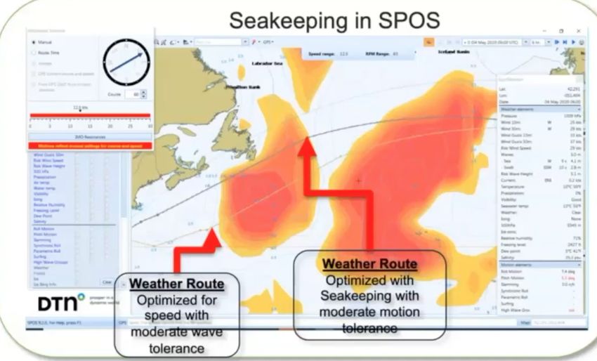
Here is an example of SPOS using seakeeping.
Next are restrictions, like ice, vertex, or The light grey line is the fixed speed with standard
customized areas, to avoid in the route. Then wave tolerance thresholds. The dark grey line,
there are custom way points, which can be using seakeeping, is set to avoid moderate motions
inserted and included in the route. through the voyage. In this case, the weather over
this route was already marginal.
But with the impact on the vessel,
via the motion predictions, the
recommended route was altered to
stay within the voyage, vessel, and
cargo limits. By using seakeeping, it
made a better decision, based on the
impact of the weather on the vessel
versus just the weather. This example
indicated the flexibility and power of
the unique routing algorithm.
Weather Route
Weather Route Optimized with
Optimized for speed Seakeeping with
with moderate moderate motion
wave tolerance tolerance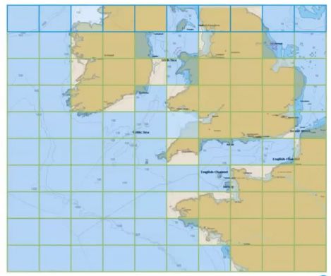
#4 Weather Optimized
Route Network
In a simplified view of a route, the
inshore waters — TSS, Safety Corridors,
                                                Comparing route network
Bathymetry, other restrictions — give little    in the marketplace — How
room for optimization. However, open
waters provide freedom and flexibility to       different services deal
avoid the weather.                              with routing?
Embedding the route network within              Best practice routes
SPOS is a revolutionary feature that            A widespread approach is using the best
treats oceans and coastal areas as broad        practice routes. These are preset and never
highways. This insight gives the master         changing. These are the “because we have
mariner the possibility to navigate safely      always done it” type of route.
from A to B. It enables safe navigation
around the globe, with 20-meter safe            Benefits: Safe, knowledgeable, known to
water depth and a 1-mile safe distance          the industry.
from coastlines. The hyper-accurate route       Issues: It’s not possible to optimize when
network safely navigates through shallow        always on the same track.
areas and mid-sea obstructions.
                                                Automatic identification system routes
The incredible value of this weather
optimized route network comes from              These types of routes are becoming more
opening navigable waters for routing. The       common. They work by looking at routing
route network enables the unique routing        trends with AIS traffic. The thinking is that
algorithm to route a ship around significant    “Where everyone else is going, it must be
weather safely.                                 good for me too.”.
                                                Benefits: Guidance updated with the latest
                                                routes used.
Optimizing weather routing
                                                Issues: Are the routes safe? What vessels
with the route network                          are using them, and are they optimized?
The goal of the weather optimized route
network is to maximize the area that a          Weather optimized route network
vessel can travel in “open waters” to           This approach also uses AIS trends to
enable navigational freedom in both             identify changes in route behavior but it’s
speed and heading and minimize the              regularly checked against the latest ENC’s by
effects of environmental forces on a            master mariners to ensure the legs are safe.
vessel’s performance.
                                                Benefits: Maximizes open areas for the
At all times, safety is the most important      ability to route vessels for performance
factor. Knowing a vessel can safely travel in   optimization. It’s also a step towards
given areas, the route network maximizes        Automated Vessel Intelligence.
those areas to avoid headwinds, which
results in the negative influences on
performance from the weather.

     Weather optimized route networks have fewer dangers that
     help for a faster and more accurate voyage planning process.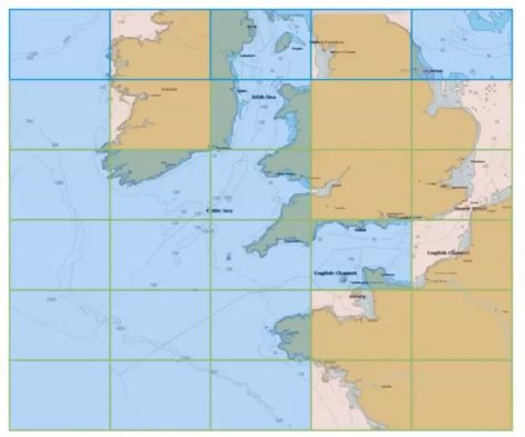
#5 Master Mariners
In weather optimized routing, accurate
weather data is only part of the puzzle.
                                                Increasing updates in
Managing uncertainty and risk is also           heavy weather
critical. This scenario is where master         The experts usually advise vessels once per
mariners, who have navigational                 day. But if they think the situation needs
knowledge and are familiar with vessels’        more attention (like this scenario), then it
characteristics in various wind and sea         will be added to the heavy weather list. The
conditions, can add real value. Their           list ensures the ship has additional checks
knowledge and skills enable the shipping        and additional updates could be sent, based
team to deliver premium route advice.		         on what the experts in shipping operations
		                                              think is necessary.
They are aware of the navigational
features, including the obstacles, sea
currents, and waters affected by pirates.       Strength of experience
Plus, they understand the processes
onboard the bridge. So, they know when it       helping clients optimize
is feasible and practical to issue new routes
or speed.
                                                their routes
		                                              The master mariners and ex-seafarers
                                                are a real strength. They speak the same
Interpreting the complex                        language as the crews onboard the vessels
                                                and understand the realities of life at sea,
weather data to advise                          as well as and the responsibilities of the
customers                                       master mariner.

In extreme weather events, like typhoons or     They are aware of the routes at sea, the
hurricanes, the standard model data alone       obstacles, sea currents, straits controlled by
is not enough. To combat this, the typhoon      pirates, and they understand the processes
data is overlaid onto the standard NMB          onboard. They understand how the bridge is
data, to enhance the view.                      utilized to change routes, fuel or speed. They
                                                are also conscious that it’s impractical to
When there is uncertainty in the forecast of    advise different speeds and courses all the
the system; the development of travel is not    time, so they provide feasible advisories.
guaranteed because the wind strength, the
speed of the system, and the development        Sometimes this means helping customers
of intensity are uncertain. These factors       to make the fastest crossing; other times,
need to be taken into account by the            the customer needs to arrive at a specific
experts when advising the master mariner.       ETA or may need to cover the route as
As there is a risk, the weather system might    economically as possible. Regardless
follow a different course, so routing options   of the priority, master mariners will
need to ensure the vessel doesn’t become        use their expertise to guide the ship
trapped by the direction of the system. It’s    .
a risk assessment that has to be made with      The master mariners also learn everything
all routing advice.                             they need to know about a client’s fleet of
                                                vessels to tailor their advice to the ship’s
                                                specific capabilities.
How the Five Essentials
Improve Performance
Route-planning is a balancing act. Ship         With growing focus on sustainable
captains must manage conflicting                business, it’s no surprise that reducing fuel
constraints to optimize each route, such as     consumption remains at the top of the list
safety, efficiency, navigation, costs, port     for the shipping industry. Ocean-going ships
rotation, ETAs, and speed ranges. Add           contribute 3% of global carbon dioxide
additional factors like trim and seakeeping     emissions. While regulations like IMO 2020
into the mix, and it’s easy to see how route-   are already helping, the five essentials
planning quickly becomes complicated.           help shipping companies to reduce fuel
                                                consumption and improve sustainability.
Weather optimized routing, built on
the five essentials, offers a solution for
captains and operators to overcome these
                                                Unburden captains
challenges. Navigate the globe safely, with     The weather optimized route network builds
minimal fuel consumption and emissions.         on decades of experience, with the pre-built
                                                ship models designed to support captains
                                                make accurate routing decisions. Combined
Save fuel and time                              with accurate weather data and advances
The five essentials help to calculate routes    in technology, it means captains have more
with the lowest voyage cost, by reducing        data onboard than ever before — supporting
time at sea and total fuel consumption.         efficient and effective decisions.
Route choice can make a massive
difference to the profitability of a voyage.    The variable speed algorithm can be used
For example, when vessels are passing           to lock in the appropriate speed to arrive
Skagerrak on their way to the east coast        on time, avoiding severe weather. Other
of the United States, they will typically ask   tools, such as voyage trim optimization,
for advice on the next part of the route.       specifically help reduce fuel consumption
They can either pass just above the British     and increase the utilization of the fleet.
Isles or sail through the English Channel. In
theory, a vessel can knock 35 hours off the     Adverse weather alerts can let captains
journey by not going through the English        know if conditions are changing on the
Channel. But the weather can be worse on        planned route. This insight enables them to
the alternative route, mitigating the time      plot an alternative route before it affects
saved. Knowing which route is best will         the performance of the voyage or becomes
vary depending on sea conditions, weather       a safety risk.
forecast, and how the vessel will perform in
those circumstances -- which is why the five
essentials are so important.
                                                Improve safety onboard
                                                ships
Gain further savings through the industry’s
                                                Using weather optimized routing,
first variable speed algorithm to help
                                                it’s easier to avoid adverse weather
bypass severe weather. Use voyage
                                                conditions. Route vessels around severe
trim optimization to further reduce
                                                weather, like gale force or higher wind
fuel consumption.
                                                fields, that impact the ability to maneuver
                                                the vessel. Have confidence that ships can
Improve sustainability                          withstand the conditions along the chosen
                                                route and ensure the safety of the crew
Weather optimized routing can provide
                                                and cargo.
fuel savings between 2- 5%, depending
on the type of vessel, the season, and the
conditions. Using less fuel helps reduce the
environmental impact of each voyage.
Conclusion Choosing the most direct route isn’t necessarily the most efficient. If vessels route through adverse conditions, it can quickly add time — and increase how much fuel is required. Forward- thinking shipping companies use weather optimized routing to ensure voyages meet their KPIs, without compromise. Weather optimized routing is essential to ensure each voyage is fuel efficient and cost-effective, while avoiding adverse or dangerous weather. The five essentials of weather optimized routing are vital for safe, sustainable, and cost-effective shipping.
You can also read