The Geodesy Observatory of Tahiti - JP Barriot, L. Sichoix, A. Fadil, F. Ye, Y. Vota, L. Mercier, Y. Verschelle
←
→
Page content transcription
If your browser does not render page correctly, please read the page content below
The Geodesy Observatory of Tahiti
   JP Barriot, L. Sichoix, A. Fadil, F. Ye,
    Y. Vota, L. Mercier, Y. Verschelle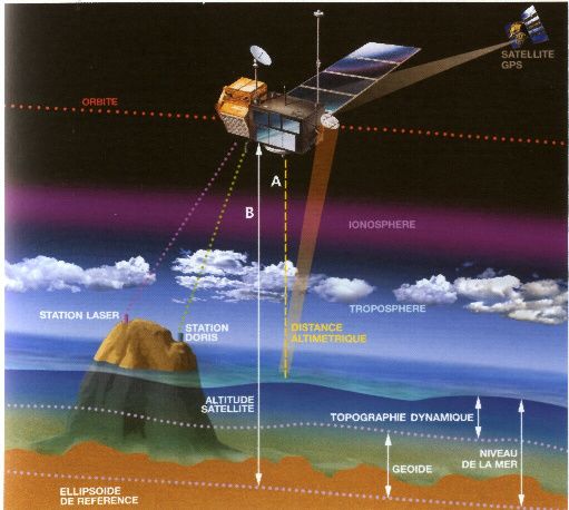
Where is the Geodesy Observatory of Tahiti ?
2/3 of USA surface, 120 islands, half-Corsica in total km2
OGT : structure UPF-CNES-NASA
• Station laser : propriété NASA, staff
  UPF+CNES, fonctionnement CNES+UPF,
• GPS : CNES, NGA, Trimble
• Stations marégraphiques : UPF
• budget annuel OGT : 150 000 euros / an (hors
  salaires, géré par l’UPF), budget consolidé
  total ~ 400 000 euros / an)
• Recherche associée à l’OGT (dont ANR, CNES
  et INSU : 80 000 euros / an
OGT : insertion internationale
UNESCO ->
ICSU (Int. Council of Scientific Union) ->
IUGG (Int. Union of Geodesy and Geophysics) ->
IAG (Int. Association of Geodesy) ->
GGOS (Global Geodetic Observing System)
L’OGT héberge l’ICET (International Center for
  Earth Tides), service de l’IAG et World Data
  Center (ICSU + IUGG + IAU)
Existing techniques in French Polynesia
• Tahiti Geodetic
• Observatory (OGT)
M
ar
qu
es
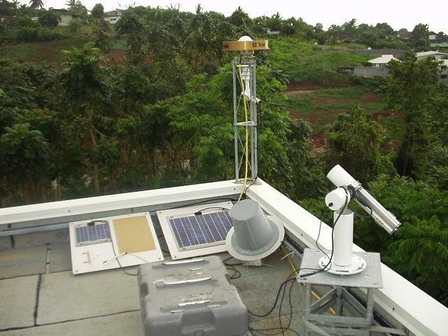
MOBLAS-SLR station
as
(co-funded by NASA, CNES and
UPF in 1997)
Tu
am
3 GPS THTI & TAH1 stations So
ot
u
(1998, 2000, 2009) c iet
y
Ga
mb
DORIS (1999) ier
Previous network tide gauges
Au
st
ra
l
2008 : 2 GPS/tide gauges deployed
in Tubuai Island & Rangiroa Atoll
by UPF
2009 : gPhone gravimeter
May2009 6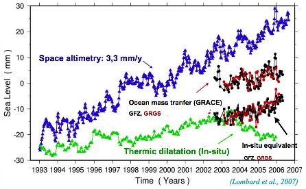
Tahiti has become a fundamental
 geodetic reference since 1997
Objectives of the laser station:
• To track satellite between 300 to 30 000
  km WITH A PRECISION OF 1 CM (OR LESS !)
• Applications:
  – To improve the gravity field and reference
    frames
  – To study the rotation of the Earth
  – To determine the sea surface topography
  – To determine mean sea level variations
  – To improve tectonic models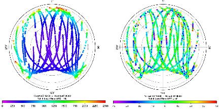
Laser tracking of satellites
R

                                                     S

géoïde
                                                                                                             D

                                                                                                                       SSH
                                                                                    G

 L’altimétrie des océans par satellite. Celui-ci mesure par radar sa distance (R) à la surface de la mer. Le suivi de sa
         trajectoire (par exemple par des balises Doris exploitant l ’effet Doppler) permet un positionnement par
         rapport à un référentiel lié au centre de la Terre, donc de connaître son altitude (S) par rapport à un ellipsoïde.
         On en déduit (de R et S) la hauteur de la surface océanique (SSH). En fait, cette surface dépend des courants
         marins dont la dynamique, dictée par les vents, les différences de température et de salinité, est fonction de la
         forme du géoïde, c ’est-à-dire de la quantité G et de D en grande partie variable dans le temps (donc
         corrigeable)
Other system:
GPSOther system: DORIS
Erasing Tahiti: the viscoelastic subsidence
        Talk by Abdel

Determination of the subsidence rate of Tahiti
from 8 years of GPS measurements: # 1.5 mm/y
Sea level measurements: GPS and collocated tide gauge
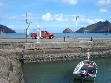
The new OGT tide gauge station in Tubuai
(Australs archipelago)

  With SHOM and Protection Civile
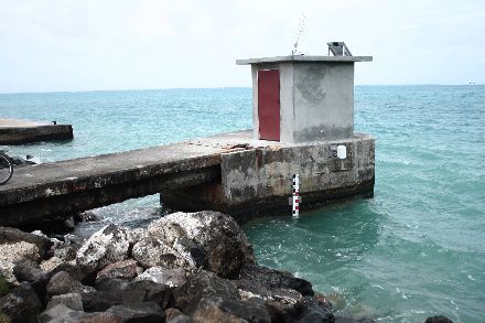
Nuku-Hiva (Marquesas) Tide Gauge Station
Mangareva Tide gauges (U. of Hawaii)
                           Station update
                           planned in 2010
Global Sea Level Variations: Sea level variation = tide gauge variation – GPS height variation
Marégraphe expérimental de Vairao (presqu’île)
                          Instrument development by Laurent
Enregistrement –type du marégraphe de Vairao à Tahiti-Iti (IFREMER)
3 µ Gal

gPHONE
                                      Spring gravimeter, top
gravity meter                         and PET (gPhone) :
(PET)
                                            0.01 µ Gal

Collaborations: Obs. Geo. Lanzarote
et de Membach, EOST
Les marées
terrestres
Réponse élastique et non-élastique de la Terre (nombres de
Love) au forçage des marées terrestres et marines en fonction
Que permet des fréquences astronomiques de forçage.
Quelles ont les effets des hétérogénéités latérales dans la croûte
le PET ? et le manteau sur cette réponse, au échelles globales et
régionales ?
Quels sont les effets des non-linéarités ?
La réponse est elle liée localement à des effets intersismiques ou
hydrologiques ?The PET gravimeter is collocated with GEOSCOPE instruments in Tahiti-Pamatai
Tahiti Gphone #59 with Geoscope
    broadband seismometers
Detection of the Sandwich Island Earthquake by Tahiti gPhone
Sandwich Isl,
6.6 2009/04/16 14:57:05 -60.215 -
26.797 10.0 SOUTH SANDWICH
ISLANDS REGIONFiltered Gravity (20 to 100 seconds)
Studies of GPS propagation at the
Geodetic Observatory of Tahiti
Comparisons of water vapor contents (IPW) of
the atmosphere from GPS modeling (red) and
radiosoundings (blue)
LEFT: skyview of the slant wet delays (mm) relative to the GPS station of the OGT (half-day)
RIGHT: residuals of the processing (multipath, antenna center of phase, unmodelled water
vapor). See poster Fadil et al, PSI2009)
Modeling of water vapor contents:
                     One-stationTroposphere Tomography

         GPS Observable: slant wed delay SWD (and SIPW)

 Our study : one GPS station
              with slant geometry

 Radon transform
Refractivity mapped along Zernike functions
 SWD α ∫       N w (s) ds =
          Trop.
                                             (ϕ , ε )e − i 2πnt ds
                    (l )                (m )
 ∫Trop. ∑ Ε nklm Rk        ( r ( s )) Yl

 A X = B

                     −1 A + α ²C −1 ) AT C −1B
        X * = ( AT C B
  =>                             X         B

    Talk by Lydie
                                                      Mai 2009       30
Studies of the erosive processes in Tahiti
Erasing Tahiti: the subsidence…and the rain !

                                           Isohyets of Tahiti Nui
3 types of slopes:
seashore 2 %, volcano 17 %, valleys : 42 %
+ heavy rains ==> intense erosion

See Guillande et al., Hildenbrand et al.
Modelling Erosive processes
LEFT: evolution of the
altitude field of Tahiti
under a mean rain of
3 m / year
RIGHT: differences
between the evolution of
the same model with a rain
of 3m /year and
1 m / year
See poster PSI 2009:
Sichoix et al.,
and booklet
«Doctoriales 09 »:
Ye et al.,
Talk by FengyinICET activities:
• International Centre for Earth Tides (ICET)
•
• http://www.upf.pf/ICET/
•
• Director: Jean-Pierre Barriot (France, French Polynesia)
•
• Overview
•
• The period from mid-2007 to mid-2009 was essentially devoted to
the translation of ICET from Brussels to Papeete. This includes three
main points: web site, the “Bulletin des Marées Terrestres, BIM”,
and GGP data stream validation.
•ICET activities (2) • • 1/ The web site of ICET was entirely migrated from the Royal Observatory of Belgium to the University of French Polynesia. • • 2/ A prototype of the new ICET database has been tested and presented at the ETS2008 meeting in Vienna and IAG2009 in BuenosAires. The database is able to store any kind of data related to Earth Tides, and not only cryogenic gravimeter data (development by Youri Verschelle) • • 3/ The server that will host the new ICET database as been bought (6 500 euros) by the University Central Bureau on Information technologies and Networks (RENATER). The ICET database is online on a trial basis.
ICET activities (3)
• 4/ A new validation software to treat the GGP data has been written. The
  purpose of this software is to discard jumps and spikes in the raw data on
  an automated, or nearly automated basis. Based on Wiener-Kolmogorov
  filtering techniques, it responds to the critics raised during the ETS2008
  meeting in Iena, by re-adding the "noise" to the GGP filtered data. We
  hope to start routine operations on GGP data by January 2010.
•
• 5/ A GGP “header” script is also under completion. The purpose of this
  script, written in Python, is to enforce a strict standardization of GGP file
  headers, in order to completely automate their validation and archiving.
•
• 6/ The BIM 144 has been completed and is on line on the ICET website.
  BIMs 145 and 146 will be on line soon (BIM 145: end september 09). All
  together, they will gather more than 25 papers presented at the ETS2008.
ICET activities (4)
• 7/ The new gPhone gravimeter of the ICET center has been
  received late December and is now in operation in Tahiti-Pamatai.
  We observed on April 16, 2008 a 6.6 Earthquake in the South
  Sandwich Islands.
•
• 8/ ICET is also participating in the deployment in Fench Polynesia of
  a network of Tide-Gauge / GPS stations (POGENET, POLynesian
  GEodetic NETwork), as a contribution to the GGOS effort.
•
• 9/ Hiring on Sept. 1 of a new Assistant Professor (Ms Lydie Sichoix)
  for the Geodesy Observatory. She will take care of some of ICET
  activities (GGP validation software).
•
Talk by Youri

Querying the new ICET Earth Tides Database
Gravity

                                  Time

Validation and correction of GGP data at ICET-Tahiti through a generalized
collocation procedure (green: raw data, blue: corrected data)
Summary of instruments in
French Polynesia:
-- SLR station (ILRS) at OGT
-- 3 permanent GPS colocated with SLR at OGT
-- 1 semi-permanent GPS at Arue
-- 1 DORIS colocated with SLR at OGT
-- 1 gPhone Earth Tides gravimeter at Pamatai
-- 7 tide gauges+GPS stations (all actives 2010):
(2 Tahiti, 1 Huahine (Society), 1 Nuku-Hiva
(Marquesas), 1 Rangiroa (Tuamotu), 1 Tubuaï
(Australs), 1 Mangareva (Gambiers)
Planned: cryogenic gravimeter, VLBI, altimetry
calibration, robotic telescope2010 plans: • Ultra-mobile laser station campaign (November 2010) • Solar eclipse (measurement of the diameter of the Sun) in July 2010 (Tuamotu) • Recovery of Japanese Boobs (ocean floor seismometers, April 2010)
Station laser ultra-mobile GRGS
         à Tahiti fin 2010
Seismic japanese boobs (Jamstec) (Mirai oceanographic vessel, recovery april 2010)
Future plans (> 2011):
•   Cryogenic gravimeter (2012 ?)
•   New laser station (2014 +)
•   VLBI station (2014 +)
•   All these three colocated at Taravao

• + Robotic telescope at Maiao (2011 ?)
• + Altimetry calibration line (2012 ?)
Un gravimètre cryogénique pour Tahiti ?

                         Gravimètre à supraconductivité
                            de la nouvelle génération
Où installer un nouveau gravimètre cryogénique ?
À TAHITI !….
CO
- la plus forte anomalie gravimétrique non expliquée au niveau des océans est dans le Pacifique
Sud-Central près de Tahiti d’après les résultats les plus récents de GRACE
(Wahr et al. 2004)Le Triplet de Slichter : le graal du gravimétricien
Translation de la graine dans le noyau externe liquide
(périodes entre 3 h et 7 h)
ar cosϕ S sin(w r t + λS + φ r )
gS (t) = +aa sin ϕ S sin(w r t + φ S )
+a p cosϕ S sin(w r t − λS + φ p )
ϕ S latitude observatoire
λS longitude observatoire
Information sur la viscosité et le saut de densité à l’ICB
•théorie et observations (Smylie, 1992 ; Smylie et al., 1993 ; Courtier et al.,
2000) très controverséesEtablissement d’une mini-
antenne VLBI à Tahiti-Iti
Observatoire
TIGO
(Conception,
Chile)Etablissement d’une ligne de calibration
altimétrique à Tahiti
Ligne de calibration ENVISAT
aux Vanuatu (Calmant et al.)
Lignes possibles de calibration
aux îles de la Société (point
amphidromique)Projet de télescope robotique à Maiao (astrométrie)
Site Possible
Maiao
Telescope robotique TAROTAnd still so many things to do … And so little time …
You can also read