The Keadby 3 Low Carbon Gas Power Station Project - SSE ...
←
→
Page content transcription
If your browser does not render page correctly, please read the page content below
The Keadby 3 Low Carbon Gas Power
Station Project

                                                 Document Ref: 5.10
                               Planning Inspectorate Ref: EN010114

The Keadby 3 (Carbon Capture Equipped Gas Fired Generating
Station) Order

Land at and in the vicinity of the Keadby Power Station site,
Trentside, Keadby, North Lincolnshire

Landscaping and Biodiversity
Management and Enhancement Plan

The Planning Act 2008
The Infrastructure Planning (Applications: Prescribed Forms and
Procedure) Regulations 2009 – Regulation 5(2)(q)

                              Applicant: Keadby Generation Limited
                                                     Date: May 2021
Document Ref: 5.10
                                    Landscaping and Biodiversity Management and
                                                               Enhancement Plan

DOCUMENT HISTORY

Document Ref     5.10/ Landscaping and Biodiversity Management and
                 Enhancement Plan
Revision         VP1.0
Document Owner   AECOM

GLOSSARY

Abbreviation     Description
AGI              Above Ground Installation - installations used to support the safe
                 and efficient operation of a pipeline; above ground installations
                 are needed at the start and end of a cross-country pipeline and at
                 intervals along the route.
AIL              Abnormal Indivisible Load - a load that cannot be broken down
                 into smaller loads for transport without undue expense or risk of
                 damage. It may also be a load that exceeds certain parameters
                 for weight, length and width.
CCGT             Combined Cycle Gas Turbine - a highly efficient form of energy
                 generation technology. An assembly of heat engines work in
                 tandem using the same source of heat to convert it into
                 mechanical energy which drives electrical generators and
                 consequently generates electricity.
CCUS             Carbon Capture, Usage and Storage - group of technologies
                 designed to reduce the amount of carbon dioxide (CO2) released
                 into the atmosphere from coal and gas power stations as well as
                 heavy industry including cement and steel production. Once
                 captured, the CO2 can be either re-used in various products,
                 such as cement or plastics (utilisation), or stored in geological
                 formations deep underground (storage).
CEMP             Construction Environmental Management Plan - a plan to outline
                 how a construction project will avoid, minimise or mitigate effects
                 on the environment and surrounding area.
CoW              Clerk of Works - a person who oversees building work in
                 progress.
DCO              Development Consent Order - made by the relevant Secretary of
                 State pursuant to The Planning Act 2008 to authorise a Nationally
                 Significant Infrastructure Project. A DCO can incorporate or
                 remove the need for a range of consents which would otherwise
                 be required for a development. A DCO can also include rights of
                 compulsory acquisition.
Defra            Department for Environment, Food and Rural Affairs

May 2021                           Page i
Document Ref: 5.10
                                     Landscaping and Biodiversity Management and
                                                                Enhancement Plan

Abbreviation      Description
EIA Regulations   Environmental Impact Assessment Regulations 2017
ES                Environmental Statement - a report in which the process and
                  results of an Environment Impact Assessment are documented.
HP                High Pressure
INNS              Invasive Non-native Species - species that have occurred outside
                  of their natural range. Invasive species have the potential to
                  hinder or prevent survival of others within the ecosystem.
ISMP              Invasive Species Management Plan - preventing and managing
                  the spread of invasive species and their potential impacts.
LBAP              Local Biodiversity Action Partnership – partnerships that operate
                  at a local authority level and help conserve and enhance
                  biodiversity. The partnerships deliver a wide range of biodiversity
                  conservation, communication and education work in their local
                  areas.
LBMEP             Landscape and Biodiversity Management and Enhancement Plan
MW                Megawatt – unit of power.
NEP               The Northern Endurance Partnership - a partnership between bp,
                  Eni, Equinor, National Grid, Shell and Total to develop
                  infrastructure to transport and store CO2 emissions.
NLC               North Lincolnshire Council
NPPF              The National Planning Policy Framework – Policy Framework
                  which first came into effect in March 2012 (with some transitional
                  arrangements) replacing the majority of national planning policy
                  other than NPSs. A revision of the NPPF was published in July
                  2018 by the Ministry of Housing, Communities and Local
                  Government and updated again in February 2019.
                  The NPPF is part of the Government's reform of the planning
                  system intended to make it less complex, to protect the
                  environment and to promote sustainable growth. It does not
                  contain any specific policies on Nationally Significant
                  Infrastructure Projects, but its policies may be considered in
                  decisions on DCOs if the Secretary of State considers them to be
                  ‘relevant’.
NPS               National Policy Statements – statements produced by
                  Government under the Planning Act 2008 providing the policy
                  framework for Nationally Significant Infrastructure Projects. They
                  include the Government’s view of the need for and objectives for
                  the development of Nationally Significant Infrastructure Projects in
                  a particular sector such as energy and are used to determine
                  applications for such development.

May 2021                            Page ii
Document Ref: 5.10
                                   Landscaping and Biodiversity Management and
                                                              Enhancement Plan

Abbreviation   Description
NSIP           Nationally Significant Infrastructure Projects – defined by the
               Planning Act 2008 and covers projects relating to energy
               (including generating stations, electric lines and pipelines);
               transport (including trunk roads and motorways, airports, harbour
               facilities, railways and rail freight interchanges); water (dams and
               reservoirs, and the transfer of water resources); waste water
               treatment plants and hazardous waste facilities.
               These projects are only defined as nationally significant if they
               satisfy a statutory threshold in terms of their scale or effect.
OMH            Open Mosaic Habitats - found mainly in urban and formerly
               industrial areas and have high biodiversity value.
The Order      The Keadby 3 (Carbon Capture Equipped Gas Fired Generating
               Station) Order
PCC            Power and Carbon Capture
PINS           Planning Inspectorate - executive agency of the Department for
               Communities and Local Government of the United Kingdom
               Government. It is responsible for determining final outcomes of
               town planning.
SoS            Secretary of State - title typically held by Cabinet Ministers in
               charge of Government Departments.
WCA            Wildlife Countryside Act 1981 (as amended) – legislation for the
               protection of animals, plants and certain habitats in the UK.
ZCH            Zero Carbon Humber - a consortium of energy and industrial
               companies and academic institutions with a shared vision to
               transform the Humber region into the UK’s first net-zero carbon
               cluster by 2040.

May 2021                          Page iii
Document Ref: 5.10
                                                              Landscaping and Biodiversity Management and
                                                                                         Enhancement Plan

CONTENTS
Executive Summary ................................................................................................... vi
1.0 Introduction....................................................................................................... 1
      1.1       Overview ............................................................................................... 1
      1.2       The Applicant ........................................................................................ 1
      1.3       What is Carbon Capture, Usage and Storage? ..................................... 2
      1.4       The Proposed Development .................................................................. 3
      1.5       The Proposed Development Site ........................................................... 6
      1.6       The Development Consent Process ...................................................... 8
      1.7       The Purpose of this Document .............................................................. 8
2.0 Legislation and Planning Policy ...................................................................... 10
      2.1       Overview ............................................................................................. 10
      2.2       Legislation ........................................................................................... 10
      2.3       Planning Policy .................................................................................... 10
      2.4       Other Guidance ................................................................................... 11
3.0 Existing Landscape and Biodiversity Features and Development Impacts..... 12
      3.1       Existing Landscape and Biodiversity Features .................................... 12
      3.2       Impacts on Landscape and Biodiversity Features ............................... 13
4.0 Impact Avoidance Requirements .................................................................... 16
      4.1       Overview ............................................................................................. 16
      4.2       Protected and Invasive Species Update Surveys ................................ 16
      4.3       Protected Species Licences ................................................................ 17
      4.4       Clerk of Works ..................................................................................... 18
      4.5       Tree Works .......................................................................................... 19
      4.6       Built Structures .................................................................................... 19
      4.7       Precautionary Working Methods ......................................................... 20
      4.8       Animal Welfare Requirements ............................................................. 23
      4.9       Lighting ................................................................................................ 24
      4.10 Habitat Reinstatement ......................................................................... 24
5.0 Landscape and Biodiversity Enhancement..................................................... 28
      5.1       Approach ............................................................................................. 28
      5.2       Habitat Enhancements ........................................................................ 29
      5.3       Comparison of Permanent Habitat Losses and Gains......................... 36
6.0 Monitoring ....................................................................................................... 40
7.0 Roles and Responsibilities ............................................................................. 41
      7.1       The Applicant and/ or the Appointed Main Contractor ......................... 41
      7.2       The Appointed Ecologist...................................................................... 41
      7.3       The Appointed Landscape Architect/ Arboriculturalist ......................... 42
8.0 References ..................................................................................................... 43
Figures ..................................................................................................................... 45

APPENDIX
APPENDIX A Seed Mixtures.................................................................................. 46
APPENDIX B Barn Owl Tower Design Parameters ............................................... 48

May 2021                                                    Page iv
Document Ref: 5.10
                                                  Landscaping and Biodiversity Management and
                                                                             Enhancement Plan

APPENDIX C Maintenance Regimes ..................................................................... 49
APPENDIX D Output from Habitat Loss/ Gain Calculator ...................................... 51

May 2021                                        Page v
Document Ref: 5.10
Landscaping and Biodiversity Management and
Enhancement Plan
EXECUTIVE SUMMARY
1 This Landscaping and Biodiversity Management and Enhancement Plan
(LBMEP) has been prepared on behalf of Keadby Generation Limited (the
Applicant) and forms part of the application for development consent for the
construction, operation (including maintenance) and decommissioning of a
new low carbon gas fired electricity generating station (the Proposed
Development). The Proposed Development is predominantly located within
the wider Keadby Power Station site, to the west of Keadby 2 Power Station,
in North Lincolnshire.
2 The purpose of this document is to set out the measures proposed to mitigate
the potential impacts and effects of the Proposed Development on landscape
and biodiversity features, and to enhance the biodiversity, landscape and
green infrastructure value of the Proposed Development Site. The final
LBMEP will be agreed as a Requirement of the draft DCO (Application
Document Ref. 2.1).
3 The Proposed Development has been designed, as far as is practicable, to
avoid or reduce effects on landscape and biodiversity features through careful
siting, development design and impact avoidance. These include measures
to avoid impacts on protected species to comply with legislation (see Chapter
11: Biodiversity and Nature Conservation (ES Volume I - Application
Document Ref. 6.2)).
4 The ecological impact assessment (Chapter 11: Biodiversity and Nature
Conservation (ES Volume I - Application Document Ref. 6.2) identifies that
the careful siting of the Proposed Development to avoid sensitive habitats has
minimised potential for sensitive habitats and species to be adversely
affected. Consequently, no likely significant ecological effects are predicted.
However, the assessment still identifies a need for proportionate embedded
ecological mitigation for purposes of good practice and legislative compliance.
Habitat re-instatement and enhancement is also required in order to
demonstrate no net loss and a net gain of biodiversity in accordance with the
requirements of national and local planning policy.
5 The landscape and visual impact assessment (Chapter 14: Landscape and
Visual Amenity (ES Volume I - Application Document Ref. 6.2)) concludes
that the Proposed Development will result in significant adverse effects on
visual amenity during construction and operation from three of the assessed
viewpoints as a result of the close distance to the Proposed Development Site
and lack of intervening vegetation:
Viewpoint 1 (Chapel Lane West, Keadby);
Viewpoint 2 (Gate Keepers Residence (Vazon Bridge), Keadby); and
Viewpoint 4 (PRoW (KEAD9, KEAD10) north of Keadby).
May 2021 Page vi
Document Ref: 5.10
Landscaping and Biodiversity Management and
Enhancement Plan
6 However, the opportunity for mitigation of the visual effects of the Proposed
Development is limited due to the size and scale of the Proposed
Development. As shown in the assessment, the effects on visual amenity
largely relate to the height of the tallest structures and as such it is considered
that the addition of landscape features such as trees and woodland would not
be effective in reducing the effects on visual amenity. However, there remains
a need for enhancements to the landscape character and improvements to
the green infrastructure network, to meet requirements of local and national
planning policy.
7 This document outlines the landscape and biodiversity impact avoidance
measures that will be implemented prior to, and during, construction of the
Proposed Development, as well as the habitat reinstatement, enhancement,
management and monitoring measures to be implemented once the Proposed
Development is operational. This would be controlled and implemented
through the final CEMP that will be developed by the contractor. A Framework
CEMP is provided as Application Doc Ref. 7.1.
8 The proposed landscape and biodiversity enhancement measures are
summarised below. The proposals have been designed to be delivered within
the existing land ownership of the Applicant and focus on enhancing the value
of existing habitats within the vicinity of the Proposed Development to include:
creation of flower-rich native grassland;
new species-rich native hedgerow plantings;
enhancement of field drains for water voles and other aquatic biodiversity;
and
installation of nest boxes for barn owl and other birds, habitat creation for
willow tit, and installation of roosting boxes for bats.
9 The Natural England Biodiversity Metric 2.0 has been used to quantify the
biodiversity value of the habitats to be lost, restored and enhanced to
demonstrate that there will be no net loss and that overall, there will be a net
gain of biodiversity as a result of the Proposed Development. In the limited
instances (as explained in the main text) where it is not been possible to
compensate like for like for habitat loss (e.g. loss of scrub) then functionally
comparable habitat will be provided (e.g. new hedgerow plantings).
10 The proposed locations for flower-rich native grassland includes areas directly
connected to, and therefore enhancing, two habitat corridors associated with
Local Wildlife Sites (LWS), namely Stainforth and Keadby Canal Corridor LWS
and Hatfield Waste Drain LWS.
May 2021 Page viiDocument Ref: 5.10
Landscaping and Biodiversity Management and
Enhancement Plan
1.0 INTRODUCTION
1.1 Overview
1.1.1 This Landscaping and Biodiversity Management and Enhancement Plan
(LBMEP) (Application Document Ref. 5.10) has been prepared by AECOM
on behalf of Keadby Generation Limited (‘the Applicant’) which is a wholly
owned subsidiary of SSE plc. It forms part of the application (the 'Application')
for a Development Consent Order (a 'DCO'), that has been submitted to the
Secretary of State (the ‘SoS’) for Business, Energy and Industrial Strategy,
under Section 37 of ‘The Planning Act 2008’ (the ‘2008 Act’).
1.1.2 The Applicant is seeking development consent for the construction, operation
and maintenance of a new low carbon Combined Cycle Gas Turbine (CCGT)
Generating Station (‘the Proposed Development’) on land at, and in the vicinity
of, the existing Keadby Power Station, Trentside, Keadby, Scunthorpe DN17
3EF (the ‘Proposed Development Site’).
1.1.3 The Proposed Development is a new electricity generating station of up to 910
megawatts (MW) gross electrical output, equipped with carbon capture and
compression plant and fuelled by natural gas, on land to the west of Keadby
1 Power Station and the (under construction) Keadby 2 Power Station,
including connections for cooling water, electrical, gas and utilities,
construction laydown areas and other associated development. It is described
in Chapter 4: The Proposed Development of the Environmental Statement
(ES) (ES Volume I - Application Document Ref. No. 6.2).
1.1.4 The Proposed Development falls within the definition of a ‘Nationally
Significant Infrastructure Project’ (NSIP) under Section 14(1)(a) and Sections
15(1) and (2) of the 2008 Act, as it is an onshore generating station in England
that would have a generating capacity greater than 50MW electrical output
(50MWe). As such, a DCO application is required to authorise the Proposed
Development in accordance with Section 31 of the 2008 Act.
1.1.5 The DCO, if made by the SoS, would be known as ‘The Keadby 3 Low Carbon
Gas Fired Generating Power Station Order' (the Order).
1.2 The Applicant
1.2.1 The Applicant, Keadby Generation Limited, is the freehold owner of a large
part of the Proposed Development Site and is a wholly owned subsidiary of
the FTSE 100-listed SSE plc, one of the UK’s largest and broadest-based
energy companies, and the country’s leading developer of renewable energy
generation. Over the last 20 years, SSE plc has invested over £20bn to deliver
industry-leading offshore wind, onshore wind, CCGT, energy from waste,
biomass, energy networks and gas storage projects. The Applicant owns and
operates the adjacent Keadby 1 Power Station and is in the process of
constructing Keadby 2 Power Station. SSE operates the Keadby Windfarm
which lies to the north and south of the Proposed Development Site and
May 2021 Page 1Document Ref: 5.10
Landscaping and Biodiversity Management and
Enhancement Plan
generates renewable energy from 34 turbines, with a total installed generation
capacity of 68MW.
1.2.2 SSE has produced a ‘Greenprint’ document (SSE plc, 2020a) that sets out a
clear commitment to investment in low carbon power infrastructure, working
with government and other stakeholders to create a net zero power system by
2040. This includes investment in flexible sources of electricity generation
and storage for times of low renewable output which will complement other
renewable generating sources, using low carbon fuels and/ or capturing and
storing carbon emissions. SSE is working with leading organisations across
the UK to accelerate the development of carbon capture, usage and storage
(‘CCUS’) clusters, including Equinor and National Grid Carbon.
1.2.3 The design of the Proposed Development demonstrates this commitment.
The Proposed Development will be built with a clear route to decarbonisation,
being equipped with post-combustion carbon capture technology, consistent
with SSE’s commitment to reduce the carbon intensity of electricity generated
by 60% by 2030, compared to 2018 levels (SSE plc, 2020b). It is intended
that the Proposed Development will connect to infrastructure that will be
delivered by the Zero Carbon Humber (ZCH) Partnership1 and Northern
Endurance Partnership (NEP)2 for the transport and offshore geological
storage of carbon dioxide.
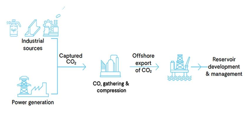
1.3 What is Carbon Capture, Usage and Storage?
1.3.1 CCUS is a process that removes carbon dioxide emissions at source, for
example emissions from a power station or industrial installation, and then
compresses the carbon dioxide so that it can be safely transported to secure
underground geological storage sites. It is then injected into layers of solid
rock filled with interconnected pores where the carbon dioxide becomes
trapped and locked in place, preventing it from being released into the
atmosphere. Plate 1 shows what is involved in the process.
1 https://www.zerocarbonhumber.co.uk/the-vision/
2 https://www.zerocarbonhumber.co.uk/news/northern-endurance-partnership/
May 2021 Page 2Document Ref: 5.10
Landscaping and Biodiversity Management and
Enhancement Plan
Plate 1: Illustration of the Carbon Capture, Usage and Storage
1.3.2 The technologies used in CCUS are proven and have been used safely across
the world for many years. Geological storage sites are located far
underground and are subject to stringent tests to ensure that they are
geologically suitable. It is expected that the storage sites will be located
offshore, in areas such as the North Sea. The NEP has been formed to
develop the offshore infrastructure to transport and store carbon dioxide
emissions in the North Sea.
1.3.3 CCUS is crucial to reducing carbon dioxide emissions and combatting global
warming. The UK Government has committed to achieving Net Zero in terms
of greenhouse gas emissions by 2050. This is a legally binding target. UK
Government policy further states that the ‘deployment of power CCUS
projects will play a key role in the decarbonisation of the electricity system at
low cost’ (HM Government, 2020a, page 47).
1.3.4 The Proposed Development will provide up to 910MWe (gross) of
dispatchable capacity and capture some 2 million tonnes of carbon dioxide
per annum, dependent upon the turbine equipment chosen and the running
hours of the plant. The Proposed Development could be up and running by
the mid-2020s and will facilitate the timely development of a major CCUS
cluster in the Humber region, making an important contribution towards the
achievement of Net Zero by 2050.
1.4 The Proposed Development
1.4.1 The Proposed Development will work by capturing carbon dioxide emissions
from the gas-fired power station and connecting into the ZCH Partnership
export pipeline and gathering network for onward transport to the Endurance
saline aquifer under the North Sea.
1.4.2 The Proposed Development would comprise a low carbon gas fired power
station with a gross electrical output capacity of up to 910MWe and associated
May 2021 Page 3Document Ref: 5.10
Landscaping and Biodiversity Management and
Enhancement Plan
buildings, structures and plant and other associated development defined in
the Schedule 1 of the draft DCO (Application Document Ref. No. 2.1) as
Work No. 1 – 11 and shown on the Works Plans (Application Document Ref.
No. 4.3).
1.4.3 At this stage, the final technology selection cannot yet be made as it will be
determined by various technical and economic considerations and will be
influenced by future UK Government policy and regulation. The design of the
Proposed Development therefore incorporates a necessary degree of
flexibility to allow for the future selection of the preferred technology in the light
of prevailing policy, regulatory and market conditions once a DCO is made.
1.4.4 The Proposed Development will include:
a carbon capture equipped electricity generating station including a CCGT
plant (Work No. 1A) with integrated cooling infrastructure (Work No. 1B),
and carbon dioxide capture plant (CCP) including conditioning and
compression equipment, carbon dioxide absorption unit(s) and stack(s)
(Work No. 1C), natural gas receiving facility (Work No. 1D), supporting
uses including control room, workshops, stores, raw and demineralised
water tanks and permanent laydown area (Work No. 1E), and associated
utilities, various pipework, water treatment plant, wastewater treatment,
firefighting equipment, emergency diesel generator, gatehouse, chemical
storage facilities, other minor infrastructure and auxiliaries/ services (all
located in the area referred to as the ‘Proposed Power and Carbon Capture
(PCC) Site’ and which together form Work No. 1);
natural gas pipeline from the existing National Grid Gas high pressure (HP)
gas pipeline within the Proposed Development Site to supply the Proposed
PCC Site including an above ground installation (AGI) for National Grid
Gas’s apparatus (Work No. 2A) and the Applicant’s apparatus (Work No.
2B) (the ‘Gas Connection Corridor’);
electrical connection works to and from the existing National Grid 400kV
Substation for the export of electricity (Work No. 3A) (the ‘Electrical
Connection Area to National Grid 400kV Substation’);
electrical connection works to and from the existing Northern Powergrid
132kV Substation for the supply of electricity at up to 132kV to the
Proposed PCC Site, and associated plant and equipment (Work No. 3B)
(the ‘Potential Electrical Connection to Northern Powergrid 132kV
Substation’);
Water Connection Corridors to provide cooling and make-up water
including:
o underground and/ or overground water supply pipeline(s) and intake
structures within the Stainforth and Keadby Canal, including temporary
cofferdam (Work No. 4A) (the ‘Canal Water Abstraction Option’);
o in the event that the canal abstraction option is not available, works to
the existing Keadby 1 power station cooling water supply pipelines and
May 2021 Page 4Document Ref: 5.10
Landscaping and Biodiversity Management and
Enhancement Plan
intake structures within the River Trent, including temporary cofferdam
(Work No. 4B) (the ‘River Water Abstraction Option’);
o works to and use of an existing outfall and associated pipework for the
discharge of return cooling water and treated wastewater to the River
Trent (Work No. 5) (the ‘Water Discharge Corridor’);
towns water connection pipeline from existing water supply within the
Keadby Power Station to provide potable water (Work No. 6);
above ground carbon dioxide compression and export infrastructure
comprising an above ground installation (AGI) for the undertaker’s
apparatus including deoxygenation, dehydration, staged compression
facilities, outlet metering, and electrical connection (Work No. 7A) and an
above ground installation (AGI) for National Grid Carbon’s apparatus
(Work No. 7B);
new permanent access from A18, comprising the maintenance and
improvement of an existing private access road from the junction with the
A18 including the western private bridge crossing of the Hatfield Waste
Drain (Work No. 8A) and installation of a layby and gatehouse (Work No.
8B), and an emergency vehicle and pedestrian access road comprising
the maintenance and improvement of an existing private track running
between the Proposed PCC Site and Chapel Lane, Keadby and including
new private bridge (Work No. 8C);
temporary construction and laydown areas including contractor facilities
and parking (Work No. 9A), and access to these using the existing private
roads from the A18 and the existing private bridge crossings, including the
replacement of the western existing private bridge crossing known as
‘Mabey Bridge’) over Hatfield Waste Drain (Work No. 9B) and a temporary
construction laydown area associated with that bridge replacement (Work
No. 9C);
temporary retention, improvement and subsequent removal of an existing
Additional Abnormal Indivisible Load Haulage Route (Work No. 10A) and
temporary use, maintenance, and placement of mobile crane(s) at the
existing Railway Wharf jetty for a Waterborne Transport Offloading Area
(Work No. 10B);
landscaping and biodiversity enhancement measures (Work No. 11A) and
security fencing and boundary treatments (Work No. 11B); and
associated development including: surface water drainage systems;
pipeline and cable connections between parts of the Proposed
Development Site; hard standings and hard landscaping; soft landscaping,
including bunds and embankments; external lighting, including lighting
columns; gatehouses and weighbridges; closed circuit television cameras
and columns and other security measures; site preparation works including
clearance, demolition, earthworks, works to protect buildings and land, and
utility connections; accesses, roads, roadways and vehicle and cycle
May 2021 Page 5Document Ref: 5.10
Landscaping and Biodiversity Management and
Enhancement Plan
parking; pedestrian and cycle routes; and temporary works associated with
the maintenance of the authorised development.
1.4.5 The Applicant will be responsible for the construction, operation (including
maintenance) and eventual decommissioning of the Proposed Development,
with the exception of the National Grid Gas compound works (Work No. 2A),
the works within the National Grid Electricity Transmission 400kV substation
(part of Work No. 3A), the works within the Northern Powergrid 132kV
substation (part of Work No. 3B), and the National Grid Carbon compound
works (Work No. 7B), which will be the responsibility of those named
beneficiaries.
1.4.6 The Proposed Development includes the equipment required for the capture
and compression of carbon dioxide emissions from the generating station so
that it is capable of being transported off-site. ZCH Partnership will be
responsible for the construction, operation and decommissioning of the
carbon dioxide gathering network linking onshore power and industrial
facilities including the Proposed Development in the Humber Region. The
carbon dioxide export pipeline does not, therefore, form part of the Proposed
Development and is not included in the Application but will be the subject of
separate consent applications by third parties, such as the Humber Low
Carbon Pipeline DCO Project by National Grid Carbon .
1.4.7 The Proposed Development will operate 24 hours per day, 7 days per week
with programmed offline periods for maintenance. It is anticipated that in the
event of CCP maintenance outages, for example, it will be necessary to
operate the Proposed Development without carbon capture, with exhaust
gases from the CCGT being routed via the Heat Recovery Steam Generator
(HRSG) stack.
1.4.8 Various types of associated and ancillary development further required in
connection with and subsidiary to the above works are detailed in Schedule 1
'Authorised Development' of the draft DCO (Application Document Ref. 2.1).
This along with Chapter 4: The Proposed Development in the ES Volume I
(Application Document Ref. 6.2) provides further description of the
Proposed Development. The areas within which each numbered Work
(component) of the Proposed Development are to be built are defined by the
coloured and hatched areas on the Works Plans (Application Document
Ref. 4.3).
1.5 The Proposed Development Site
1.5.1 The Proposed Development Site (the ‘Order Limits’) is located within and near
to the existing Keadby Power Station site near Scunthorpe, Lincolnshire and
lies within the administrative boundary of North Lincolnshire Council (NLC).
The majority of land is within the ownership or control of the Applicant (or SSE
associated companies) and is centred on national grid reference 482351,
411796.
May 2021 Page 6Document Ref: 5.10
Landscaping and Biodiversity Management and
Enhancement Plan
1.5.2 The existing Keadby Power Station site currently encompasses the
operational Keadby 1 and (under construction) Keadby 2 Power Station sites,
including the Keadby 2 Power Station Carbon Capture and Readiness reserve
space.
1.5.3 The Proposed Development Site encompasses an area of approximately
69.4 hectares (ha). This includes an area of approximately 18.7ha to the west
of Keadby 2 Power Station in which the generating station (CCGT plant,
cooling infrastructure and CCP) and gas connection will be developed (the
Proposed PCC Site).
1.5.4 The Proposed Development Site includes other areas including:
Previously developed land, along with gas, towns water and other
connections, and access routes, within the Keadby Power Station site;
the National Grid 400kV Substation located directly adjacent to the
Proposed PCC Site, through which electricity generated by the Proposed
Development will be exported;
Emergency Vehicle Access Road and Potential Electrical Connection to
Northern Powergrid Substation, the routes of which utilise an existing farm
access track towards Chapel Lane and land within the existing Northern
Powergrid substation on Chapel Lane;
Water Connection Corridors:
o Canal Water Abstraction Option which includes land within the existing
Keadby Power Station site with an intake adjacent to the Keadby 2 Power
Station intake and pumping station and interconnecting pipework;
o River Water Abstraction Option which includes a corridor that spans
Trent Road and encompasses the existing Keadby Power Station
pumping station, below ground cooling water pipework, and
infrastructure within the River Trent; and
o a Water Discharge Corridor which includes an existing discharge pipeline
and outfall to the River Trent and follows a route of an existing easement
for Keadby 1 Power Station;
an existing river wharf at Railway Wharf (the Waterborne Transport
Offloading Area) and existing temporary haul road into the into the existing
Keadby 1 Power Station Site (the ‘Additional Abnormal Indivisible Load
(AIL) Route’);
a number of temporary Construction Laydown Areas on previously
developed land and adjoining agricultural land; and
land at the A18 Junction and an existing site access road, including two
existing private bridge crossing of the Hatfield Waste Drain lying west of
Pilfrey Farm (the western of which is known as Mabey Bridge, to be
replaced, and the eastern of which is termed Skew Bridge) and an existing
temporary gatehouse, to be replaced in permanent form.
May 2021 Page 7Document Ref: 5.10
Landscaping and Biodiversity Management and
Enhancement Plan
1.5.5 In the vicinity of the Proposed Development Site the River Trent is tidal,
therefore parts of the Proposed Development Site are within the UK marine
area. No harbour works are proposed.
1.5.6 Further description of the Proposed Development Site and its surroundings is
provided in Chapter 3: The Site and Surrounding Area in ES Volume I
(Application Document Ref. 6.2).
1.6 The Development Consent Process
1.6.1 As a NSIP project, the Applicant is required to obtain a DCO to construct,
operate and maintain the generating station, under Section 31 of the 2008 Act.
Sections 42 to 48 of the 2008 Act govern the consultation that the promoter
must carry out before submitting an application for a DCO and Section 37 of
the 2008 Act governs the form, content and accompanying documents that
are required as part of a DCO application. These requirements are
implemented through the Infrastructure Planning (Applications: Prescribed
Forms and Procedure) Regulations 2009 (as amended) (‘APFP Regulations’)
which state that an application must be accompanied by an ES, where a
development is considered to be ‘EIA development’ under the Infrastructure
Planning (Environmental Impact Assessment) Regulations 2017 (the EIA
Regulations).
1.6.2 An application for development consent for the Proposed Development has
been submitted to the Planning Inspectorate (PINS) acting on behalf of the
Secretary of State. Subject to the Application being accepted (which will be
decided within a period of 28 days following receipt of the Application), PINS
will then examine it and make a recommendation to the Secretary of State,
who will then decide whether to make (grant) the DCO.
1.7 The Purpose of this Document
1.7.1 The purpose of this document is to set out the measures proposed to mitigate
the effects of the Proposed Development on landscape and biodiversity
features, and to enhance the biodiversity, landscape and green infrastructure
value of the Site, to secure compliance with relevant national and local
planning policies.
1.7.2 In order to avoid potential conflicts in approach to impact avoidance and
enhancement, this document identifies the measures required for both
landscape and biodiversity together, to demonstrate a cohesive strategy.
1.7.3 The document is structured as follows:
Section 2 summarises relevant legislation and planning policy;
Section 3 describes the existing landscape and biodiversity features and
the potential impacts and effects of the Proposed Development;
May 2021 Page 8Document Ref: 5.10
Landscaping and Biodiversity Management and
Enhancement Plan
Section 4 outlines the requirements for impact avoidance, both during
advance works and during the construction phase;
Section 5 describes the proposals for landscape and biodiversity
enhancement and the measures required for their effective management
and maintenance. The areas of the Proposed Development Site to which
the different proposals will be applied are illustrated in Figure 1;
Section 6 describes the high-level approach to monitoring of the success
of the proposed landscape and biodiversity habitat interventions; and
Section 7 describes the roles and responsibilities of all parties involved in
the delivery of the management and enhancement proposals.
May 2021 Page 9Document Ref: 5.10
Landscaping and Biodiversity Management and
Enhancement Plan
2.0 LEGISLATION AND PLANNING POLICY
2.1 Overview
2.1.1 The legislation and planning policy relevant to construction of the Proposed
Development and the specification of landscape and biodiversity mitigation
and enhancement is listed in this section. This legislation and planning policy
have been considered when formulating this Plan. Appendix 11A:
Biodiversity and Nature Conservation Legislation and Planning Policy (ES
Volume II – Application Document Ref. 6.3) provides more details on this
relevant legislation and planning policy for biodiversity.
2.2 Legislation
2.2.1 The following legislation has been considered in the preparation of this Plan:
The Conservation of Habitats and Species Regulations 2017 (as
amended);
Wildlife and Countryside Act (WCA) 1981 (as amended);
Countryside and Rights of Way Act 2000;
Natural Environment and Rural Communities (NERC) Act 2006;
Protection of Badgers Act 1992;
Wild Mammals (Protection) Act 1996;
Environmental Protection Act 1990; and
Invasive Alien Species (Enforcement and Permitting) Order 2019.
2.3 Planning Policy
2.3.1 Relevant national planning policy that has been considered in relation to
landscape and biodiversity impact avoidance, mitigation and enhancement is
as follows:
Overarching National Policy Statement (NPS) for Energy (EN-1)
(Department for Energy and Climate Change (DECC), 2011a);
NPS for Fossil Fuel Electricity Generating Infrastructure (EN-2) (DECC,
2011b);
National Planning Policy Framework (NPPF) (Ministry of Housing,
Communities and Local Government (MHCLG), 2019); and
European Landscape Convention (Council of Europe, 2000).
2.3.2 The local planning policies that are relevant to the Proposed Development
Site are set out in the following documents:
May 2021 Page 10Document Ref: 5.10
Landscaping and Biodiversity Management and
Enhancement Plan
North Lincolnshire Local Plan Saved Policy LC5: Species Protection (NLC,
2003a);
North Lincolnshire Local Plan Saved Policy LC6: Habitat Creation (NLC,
2003a);
North Lincolnshire Local Plan Saved Policy LC12: Protection of Trees,
Woodland and Hedgerows (NLC, 2003a);
Emerging North Lincolnshire New Local Plan Policy DQE3p: Biodiversity
and Geodiversity (NLC, 2020); and
Emerging North Lincolnshire New Local Plan Policy DQE8p: Climate
Change and Low Carbon Living (NLC, 2020).
2.4 Other Guidance
2.4.1 Other guidance that is relevant context includes:
North Lincolnshire Supplementary Planning Guidance 3: Design in the
Countryside (NLC, 2003b);
Natural England, Forestry Commission and Department for Environment,
Food and Rural Affairs (Defra) Standing Advice on protected sites and
species (gov.uk);
The National Pollinator Strategy (Defra, 2014);
Local Biodiversity Action Plan (LBAP) for Lincolnshire (Lincolnshire
Biodiversity Partnership, 2011);
Humberhead Levels National Character Area (NCA Profile 39) (Natural
England, 2014); and
North Lincolnshire Landscape Character Assessment and Guidelines
(Trent Levels Landscape Character Area and Flat Drained Farmland
Landscape Character Type) (NLC, 1999).
May 2021 Page 11Document Ref: 5.10
Landscaping and Biodiversity Management and
Enhancement Plan
3.0 EXISTING LANDSCAPE AND BIODIVERSITY FEATURES AND
DEVELOPMENT IMPACTS
3.1 Existing Landscape and Biodiversity Features
Habitats
3.1.1 The habitats of relevance to this Plan are described in Appendix 11C:
Preliminary Ecological Appraisal Report (ES Volume II – Application
Document Ref. 6.3).
3.1.2 The habitats that would be affected by permanent or temporary land-take
comprise:
‘modified grasslands’ encompassing species-poor improved and semi-
improved neutral grasslands (located at the Proposed PCC Site and the
Highway Improvements on the A18);
dense scrub comprising stands of mixed scrub and hawthorn dominated
scrub (located respectively on the boundary of the Proposed PCC Site with
the former Keadby Ash Tip, and in the wayleave of the overhead electricity
transmission lines associated with the existing National Grid 400kV
Substation);
ephemeral/ short perennial vegetation contributing to open mosaic habitats
(OMH) (located on the south-west corner of the Proposed PCC Site where
there is a minor overlap with the margin of the former Keadby Ash Tip);
intensively managed arable farmland (located within areas proposed for
temporary construction laydown);
unvegetated disturbed bare ground (located within the temporary soil
storage compound for Keadby 2 Power Station, part of the Proposed PCC
Site);
minor field drains (encompassing the unnamed drain located within
Proposed PCC Site that will be lost (Drain 4), and other drains on the
alignment of Emergency Vehicle Access Road and potential 132kV
electrical connection to Northern Powergrid Substation);
watercourses comprising the Hatfield Waste Drain (which is crossed by the
existing Mabey Bridge which is to be replaced), the Stainforth and Keadby
Canal (within which the potential Canal Water Abstraction Option would be
constructed) or the River Trent (within which the potential River Water
Abstraction Option would be constructed).
3.1.3 Additional areas of land to be utilised solely for purposes of landscape and
biodiversity enhancement are shown on Figure 1 of this LBMEP. The existing
habitats within these landscape and biodiversity enhancement areas (as
mapped and described in Appendix 11C, ES Volume II - Application
Document Ref. 6.3) are:
May 2021 Page 12Document Ref: 5.10
Landscaping and Biodiversity Management and
Enhancement Plan
‘modified grasslands’ of species-poor improved types (located on road
verges or in small fields adjacent to the permanent access road off the
A18, also includes retained vegetation within the Proposed PCC Site on
the alignment of the overhead electricity transmission lines associated with
the existing National Grid 400kV Substation);
existing tarmac car park (sealed surface) to be broken out and replaced
(located adjacent to the permanent access road off the A18); and
minor field drains (located on the boundaries of the Proposed PCC Site).
Protected/ Notable Species
3.1.4 The protected species of relevance to this Plan, because of their presence in
the potential zone of influence of construction activities, are:
badger;
water vole;
otter (not recorded during baseline surveys but with potential to establish
before construction);
bats (but not bat roosts);
nesting birds (including ground nesting species); and
fish.
3.1.5 In addition, drains associated with the Proposed Development Site support
the following invasive non-native flora and fauna:
zebra mussel;
demon shrimp;
Nuttall’s waterweed; and
New Zealand pigmyweed.
3.2 Impacts on Landscape and Biodiversity Features
3.2.1 Table 1 summarises the permanent losses of habitats during construction of
the Proposed Development. These are the habitat losses relevant to
quantification of the balance of habitat loss to gain (see Section 5.3 and
Appendix D).
May 2021 Page 13Document Ref: 5.10
Landscaping and Biodiversity Management and
Enhancement Plan
Table 1: Permanent Losses of Semi-natural Habitats
Habitat loss
Affected habitat Construction activity
(ha)
Site clearance for
construction of Proposed 10.12ha
Modified grassland PCC Site
(encompassing all species-
poor grasslands) A18 Junction Improvement 0.24ha
Mabey Bridge replacement 0.30ha
Unvegetated disturbed
Site clearance for
ground (unsealed land
construction of Proposed 4.58ha
currently within Keadby 2
PCC Site
construction site)
Site clearance for
Mixed scrub construction of Proposed 0.08ha
PCC Site
Site clearance for
Hawthorn scrub construction of Proposed 0.01ha
PCC Site
Site clearance for
OMH construction of Proposed 0.25ha
PCC Site
Infilling of minor drain (Drain
4) bisecting Keadby
Common during site
clearance for Proposed PCC
Species-poor drain Site. 0.04ha
Construction of bridge for
Emergency Vehicle Access
Road over Glew Drain.
Total 15.62ha
3.2.2 There would also be minor/ very small-scale temporary disturbance impacts
on semi-natural habitats and arable farmland, including deferral of pre-existing
commitments of the Applicant for reinstatement of habitats affected during
construction of Keadby 2 Power Station. Not all of these impacts may occur,
as some options will not be required at the time of final design when there has
been a final decision on the routes for the 132kV Electrical Connection to the
May 2021 Page 14Document Ref: 5.10
Landscaping and Biodiversity Management and
Enhancement Plan
Northern Powergrid Substation and the location of the proposed cooling water
intake.
3.2.3 The temporary impacts are:
deferral of reinstatement of the agricultural land and associated boundary
hedgerows and drains on the alignment of the existing temporary
construction haul road currently in use for construction of Keadby 2 Power
Station;
deferral of habitat reinstatement for the Keadby 2 Power Station (if
required based on measures agreed for Keadby 2 Power Station) at the
location of the potential Canal Water Abstraction Option on the Stainforth
and Keadby Canal due to the potential requirement for additional
construction works for the Proposed Development;
use of intensively managed arable farmland for temporary construction
laydown; and
possible small-scale disturbance of species-poor road verges and flood
bank grasslands, e.g. for vehicle access, Mabey Bridge Replacement and
short duration laydown of materials, during A18 Junction Improvement and
installation of an eel screen on the potential River Water Abstraction
Option (if required).
3.2.4 Given the limited impacts on habitats, construction and operation of the
Proposed Development also has limited potential, in the absence of mitigation,
to adversely affect protected and notable species through direct impacts
(killing/ injury), disturbance and habitat loss. The species requiring mitigation
are those identified above in Section 3.1
May 2021 Page 15Document Ref: 5.10
Landscaping and Biodiversity Management and
Enhancement Plan
4.0 IMPACT AVOIDANCE REQUIREMENTS
4.1 Overview
4.1.1 The care that has been taken when configuring the layout of the Proposed
Development maintains the functionality of existing green infrastructure
networks, wildlife networks and habitat linkages. The Proposed Development
therefore complies fully with the related requirements of planning policy, and
even more so once the additional proposed habitat reinstatement and
enhancement measures are also considered (see Section 5).
4.1.2 The impact avoidance measures outlined below (Section 4.2 onwards) will be
implemented, as relevant and appropriate, prior to and during the construction
phase, the purpose being to minimise the impact of works on landscape and
biodiversity features.
4.1.3 These measures will be applied in order to meet legislative and planning policy
requirements for protected species, or as part of standard construction
environmental best practice.
4.1.4 The commitment to provide these measures has been considered when
assessing the likely impacts and effects of the Proposed Development on
landscape and biodiversity features in Chapter 11: Biodiversity and Nature
Conservation and Chapter 14: Landscape and Visual Amenity (ES Volume I
- Application Document Ref. 6.2).
4.1.5 Avoidance and mitigation of potential impacts on the environment through, for
example, noise, vibration or emissions to air or water associated with the
operational Proposed Development are not covered within this Plan. While
such impacts could affect biodiversity, these effects have been appropriately
controlled and mitigated through the design and impact avoidance measures
presented in Chapter 8: Air Quality and Chapter 9: Noise and Vibration of
Environmental Statement (ES) Volume I (Application Document Ref. 6.2).
In addition, there are other permitting, good practice, legislative, policy and
regulatory mechanisms that necessitate the control and prevention of such
impacts. The relevant measures are therefore prescribed in other chapters of
the ES and do not need to be included within this Plan.
4.2 Protected and Invasive Species Update Surveys
4.2.1 Appropriately experienced ecologists will complete site walkovers in advance
of mobilisation or other potential advance works to re-confirm the ecological
baseline conditions and identify any new ecological risks. Updated species
surveys will also be undertaken to determine the status of protected and
invasive non-native species (INNS) identified as present or potentially present
at the Proposed Development Site to inform mitigation requirements and
support protected species licence applications. These updated surveys will be
completed sufficiently far in advance of construction works to account for
May 2021 Page 16Document Ref: 5.10
Landscaping and Biodiversity Management and
Enhancement Plan
seasonality constraints and to allow time for the implementation of any
necessary mitigation prior to construction.
4.2.2 Existing or potential landscape and biodiversity constraints that will be re-
assessed during update surveys are as follows:
bats – update roost surveys of trees adjacent to the Proposed
Development Site;
breeding birds – nest checks of vegetation to be cleared, where necessary;
otter – updated survey for signs of presence;
water vole – updated survey to determine current distribution and
population size;
badger – updated survey to determine current distribution and activity of
badger setts; and
INNS – updated survey to re-confirm the locations of species that may be
disturbed during construction.
4.2.3 Should any new protected or invasive species constraints be identified as a
result of the updated surveys, the LBMEP would be updated to address these
constraints. Any requirement for additional impact avoidance or mitigation will
be discussed and agreed with NLC and/ or the relevant statutory consultees,
except where this will otherwise be addressed through the process for
obtaining any necessary protected species licences.
4.2.4 Any additional surveys will be instructed during the advance works, site
clearance and construction phases as identified as necessary by the
ecologist, or otherwise as identified and requested by the Applicant or their
contractor(s) when implementing the final approved Construction
Environmental Management Plan (CEMP) and other relevant approved plans
and permits. These may be required, for example, based on the construction
programme, working requirements or following identification of specific issues
and constraints not covered by previous advice.
4.3 Protected Species Licences
4.3.1 All necessary protected species licences will be applied for and obtained prior
to undertaking any works likely to affect the conservation status of these
species, as required by the relevant legislation. Based on the findings of
Chapter 11: Biodiversity and Nature Conservation (ES Volume I -
Application Document Ref. 6.2) and pending the findings of the proposed
updated protected species surveys, the following protected species licences
may be required:
badger licence - if direct and indirect disturbance impacts on badger setts
are likely and unavoidable (although currently this is not anticipated as
likely); and
May 2021 Page 17Document Ref: 5.10
Landscaping and Biodiversity Management and
Enhancement Plan
water vole licence – if water voles are still present at the time of
construction and need to be displaced or relocated from construction
working areas.
4.3.2 Habitat compensation/ restoration and enhancement will also be required if a
protected species licence is needed. Outline proposals for habitat restoration
and enhancement in relation to water vole are included within Section 5 of this
LBMEP. It is premature and unnecessary to define similar measures for
badger at this time, given this is a highly mobile species. Instead, it is noted
that the Applicant has sufficient land within their control to meet any such
requirements, including land within the former Keadby Ash Tip.
4.3.3 Should licences be required, it is recognised that this could (a) impose
restrictions on the timing of construction activities and (b) dictate lead-in times
for agreement and completion of pre-construction mitigation. This will
therefore be addressed in the final construction programme based on the
findings of the updated surveys.
4.4 Clerk of Works
4.4.1 The Applicant will agree when a Clerk of Works (CoW) should be present
during construction in consultation with the ecologist and landscape architect
based on relevant environmental commitments, the findings of the updated
surveys, the requirements of protected species, and with reference to the
relevant project programmes.
4.4.2 Immediately prior to site clearance and the start of construction in each
relevant part of the Proposed Development Site, further site walkover surveys
will be undertaken by an appropriately experienced CoW to confirm that the
risks associated with the Proposed Development Site remain as previously
assessed and/ or to confirm the correct implementation of impact avoidance
measures (e.g. tree protection fencing, protected species stand-offs and other
protection measures).
4.4.3 The scope of the required walkover surveys will be defined on a case by case
basis, in consultation with the project team, and NLC or other statutory
consultees as necessary, based on the specific risks associated with each
relevant part of the Proposed Development and the findings of any preceding
updated surveys as detailed above in Section 4.2. This will be controlled and
implemented through the final CEMP that will be developed by the contractor.
A Framework CEMP is provided as Application Doc Ref. 7.1.
4.4.4 Relevant site staff will receive toolbox talks from the CoW as necessary on
the relevant ecological risks present, legal requirements, working
requirements necessary to comply with this legislation, and the final approved
landscaping and biodiversity management and enhancement measures.
Toolbox talks will be repeated as necessary over the duration of the
construction works.
May 2021 Page 18You can also read