The nationwide 'ZNIEFF' inventory in France: a free dataset of more than one million synthesised species data in zones of high ecological value
←
→
Page content transcription
If your browser does not render page correctly, please read the page content below
PREPRINT

   Author-formatted, not peer-reviewed document posted on 14/07/2021

           DOI: https://doi.org/10.3897/arphapreprints.e71265

 The nationwide ‘ZNIEFF’ inventory in
 France: a free dataset of more than
one million synthesised species data in
      zones of high ecological value

Fanny Lepareur, Mathieu Manceau, Yorick Reyjol, Julien Touroult,
Solène Robert, Frédéric Vest, Arnaud Horellou, Laurent Poncet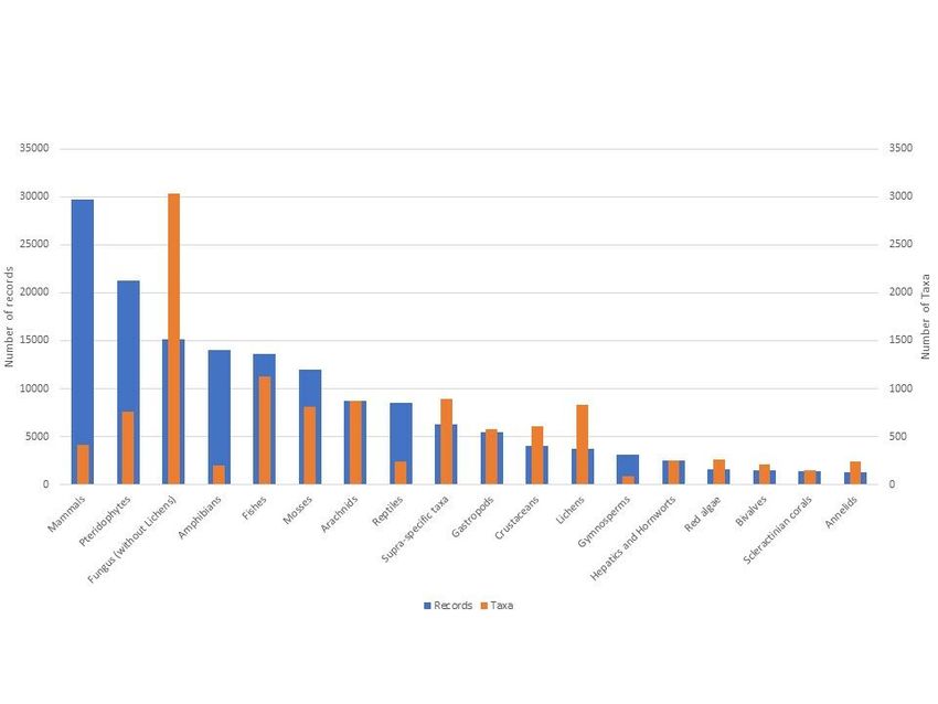
Author-formatted, not peer-reviewed document posted on 14/07/2021. DOI:
                https://doi.org/10.3897/arphapreprints.e71265

The nationwide ‘ZNIEFF’ inventory in France: a
free dataset of more than one million synthesised
species data in zones of high ecological value
Fanny Lepareur‡, Mathieu Manceau‡, Yorick Reyjol‡, Julien Touroult‡, Solène Robert‡, Frédéric Vest‡,
Arnaud Horellou‡, Laurent Poncet‡
    ‡ UMS Patrimoine Naturel (PatriNat) (OFB-CNRS-MNHN), Paris, France

   Corresponding author: Fanny Lepareur (fanny.lepareur@mnhn.fr)

Abstract

Background

In France, a ‘natural zone of ecological, faunistic or floristic value’ (Zone Naturelle d'Intérêt
Écologique, Faunistique et Floristique - ZNIEFF) is a natural area regionally known for its
remarkable ecological characteristics. The ZNIEFF inventory is a naturalist and scientific
survey program launched in 1982 by the Ecology Ministry, with support from the French
National Museum of Natural History (MNHN).

New information

This paper describes the ZNIEFF national dataset, which comprises 1 013 25 synthesised
data for various animal (38%), vegetal (59%) and fungus (2%) species in terrestrial and
marine zones (the last download took place on 26 May 2020). A total of 19 842 sites
throughout continental France as well as in the overseas departments and territories
(Guadeloupe, Martinique, Mayotte, La Réunion, French Guiana, Saint-Martin, Saint-
Barthélemy and Saint-Pierre-et-Miquelon) are included in the ZNIEFF dataset (last
download: 26 May 2020). This dataset is now available in open access.

All data were collected by skilled naturalists using professional protocols over almost 40
years. They consist mainly of observations of rare, threatened or endemic species, all
validated by regional experts. Data is updated twice a year after national validation. Some
of the observed of species, the so-called ‘trigger species’ or ‘determinant’ species, are of
central interest for a site to be considered a ZNIEFF (zone of high ecological value). This
concerns more than 35 000 taxa, mainly angiosperms, insects, fungi, birds and fish.

© Lepareur F et al. This is an open access article distributed under the terms of the Creative Commons Attribution License (CC BY
4.0), which permits unrestricted use, distribution, and reproduction in any medium, provided the original author and source are
credited.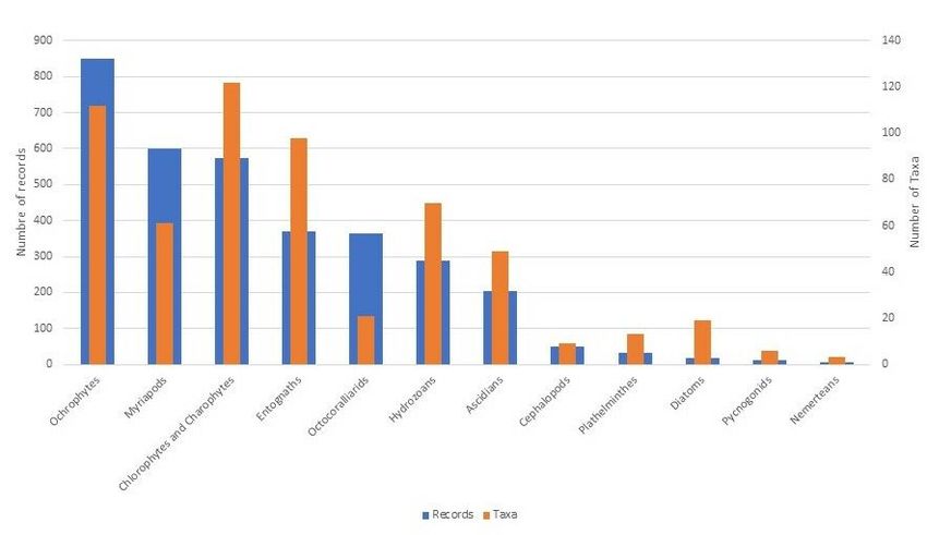
Author-formatted, not peer-reviewed document posted on 14/07/2021. DOI:
            https://doi.org/10.3897/arphapreprints.e71265

Keywords
key biodiversity areas, trigger species, natural heritage survey, terrestrial and marine
biodiversity

Introduction
In France, a ‘natural zone of ecological, faunistic or floristic value’ (Zone Naturelle d'Intérêt
Écologique, Faunistique et Floristique - ZNIEFF) is a natural area regionally known for its
remarkable ecological characteristics (Horellou et al. 2017). The ZNIEFF inventory is a
naturalist and scientific survey program launched in 1982 by the Ecology Ministry, with
support from the French National Museum of Natural History (MNHN). The ZNIEFF
programme was then integrated in French environmental law on 8 January 1993 (Art. 23,
law no. 93-24). The regulatory framework for ZNIEFFs was reinforced over time through
several circulars, decrees and laws. The aim of this inventory is to use naturalist
knowledge obtained in the field to determine the location of natural sites (terrestrial and
marine) with high ecological value in France and to assist in land-planning issues. This
program is conceptually similar to the Key Biodiversity Areas (KBA) initiative developed on
the international level (IUCN 2016), but with a more regional and national scale of issues.

The ZNIEFF inventory is included in the National Inventory of Natural Heritage (INPN) (Pon
cet 2013) as part of the national information system for sharing observational data on
biodiversity in France (Système d’Information sur la Nature et les Paysages, SINP). The
ZNIEFF species dataset is therefore now available in open access in both national (INPN-
OpenObs) and global (GBIF) biodiversity web platforms.

General description
Purpose: The inclusion of a site in the ZNIEFF inventory is based on the presence of a
species or associations of species of high ecological value (named ‘determinant species’ in
the ZNIEFF terminology). The presence of at least one determinant species makes it
possible to create a ZNIEFF. The data on remarkable species and habitats in the area are
collected, analysed and synthesised (Horellou et al. 2017). There are two types of ZNIEFF.
Type I ZNIEFFs are ecologically homogeneous areas, defined by the presence of species,
associations of species or habitats that are rare, remarkable or characteristic of the
regional natural heritage. Type II ZNIEFFs usually correspond to larger areas that integrate
functional and landscaped natural zones. Type I ZNIEFFs can be included in type II
ZNIEFFs (Horellou et al. 2014).

The Regional Scientific Council for Natural Heritage (CSRPN) scientifically validates the
naturalist surveys (sites and species) in each administrative region in close relationship
with the regional services of the Ministry of Ecology and their scientific secretariat

                                                      2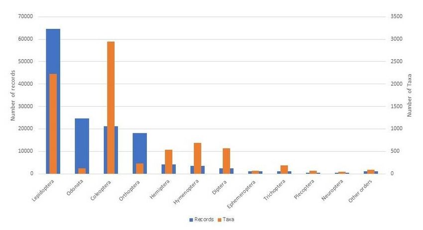
Author-formatted, not peer-reviewed document posted on 14/07/2021. DOI:
            https://doi.org/10.3897/arphapreprints.e71265

‘ZNIEFF’, while the French National Museum of Natural History is in charge of the national
consistency.

A ZNIEFF is not a ‘protected area’ per se, but rather a survey of naturalistic knowledge on
specific sites known to shelter remarkable species and/or characterized by remarkable
environmental features (e.g. a moor on serpentine). The ZNIEFF inventory is central for
prioritizing issues of natural heritage, defining the national biodiversity strategy and its
regional sub-strategies, creating protected areas and for generating new knowledge. It has
been one of the most important item when defining the French National Strategy for the
Creation of Protected Areas (SCAP). In 1993, the ZNIEFF inventory facilitated the
implementation of the European Habitat Directive concerning the conservation of natural
and semi-natural habitats as well as wild fauna and flora, enabling the constitution of an
operational Natura 2000 network of sites. Finally, it constitutes a decision-making tool and
is frequently used for environmental studies related to land planning. Generally speaking,
the ZNIEFF inventory has been one of the main factors in collecting and gathering
naturalist knowledge on the national level for almost 40 years.

Additional information: The notion of ‘determinance’ is the cornerstone of the ZNIEFF
inventory and literally means ‘which determines the value and justifies the choice of the
geographic area’. Each ZNIEFF must necessarily contain at least one ‘determinant’
species (also called ‘trigger’ species in the scientific literature) to be considered as such.
The determining characteristic is the intrinsic value of the species (e.g. localised,
threatened on the regional, national or international level, endemic, at the limit of the range,
etc.) combined with the particular conditions of the site (notably, the importance of the
species population in the region with respect to its presence in other regions and its global
geographic distribution). In addition to these determinant species, the ZNIEFF inventory
also takes into account determinant habitats, which contribute to the selection of the area
on their own value or that of the species they shelter. Data related to other (non
determinant) species are also collected during field surveys and generally included in the
dataset, given that it is useful for understanding the global ecological functioning of the
ZNIEFF or to anticipate global anthropogenic threats or more local impacts (e.g. extension
of the range of species due to climate change, urbanization). Only data concerning species
(not habitats) will be presented in this datapaper, as habitat data do not yet benefit from
viewing and downloading tools on the national level.

There is a particular case of species with ‘confidential distribution’. This concerns a limited
number of species in a given region that are particularly ‘sensitive’, i.e. subject to harmful
human activity, and for which the availability of data is likely to increase the likelihood of the
harmful activity occurring (Chapman and Grafton 2008). This may concern species which
are threatened, rare or and of high heritage interest and for which the dissemination of
information represents (in the regional context) a risk of targeted destruction. This
dissemination of information could also seriously affect the conservation status of the
population of a species or the habitat that shelters it. The confidentiality of a species must
however remain exceptional and is assessed on a case-by-case basis on the regional level
by the scientific council. The corresponding data are excluded from the free diffusion
dataset on the INPN website and the GBIF portal.

                                                      3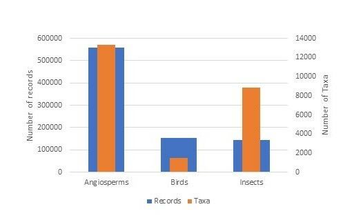
Author-formatted, not peer-reviewed document posted on 14/07/2021. DOI:
           https://doi.org/10.3897/arphapreprints.e71265

Project description
Personnel: In order to guarantee the consistency of the information, data is collected using
a common framework (Horellou et al. 2017) defined jointly by a scientific and technical
coordination team based in the French National Museum of Natural History (UMS PatriNat)
and the Ecology Ministry. The observations are transmitted by the wide-ranging naturalist
network in France, including independent professional and amateur naturalists,
associations for nature studies and protection, public institutions, contractors (private
sector), learned societies, etc. The Regional Scientific Councils for Natural Heritage
(CSRPN) validate the local inventories in close conjunction with the regional services of the
Ecology Ministry and their scientific secretariat 'ZNIEFF' before transmission to the MNHN
for validation to ensure its technical and scientific consistency. The data is then sent to the
ZNIEFF database via a web application specifically designed for this purpose.

Funding: The Ecology Ministry coordinates the regional services and provides financial
support for the annual operation of the ZNIEFF programme.

Sampling methods
Sampling description: Sampling is focused on areas of high biodiversity identified on the
regional scale. These zones (19 842 registered as ZNIEFFs on May 2020; Table 1) are
pre-identified based on the knowledge of field naturalists, often through the primary study
of vegetation, but occasionally also on abiotic characteristics (e.g. a moor on a serpentine
substrate). The subsequent inventory of various taxa on these sites helps to confirm (or not
confirm) their value for conservation. ZNIEFF data come mainly from direct field
observations, but can also rely on literature sources, collections and other databases. A
great variety of sampling methods and protocols are used to collect data, depending on the
environment and the taxon concerned.

Quality control: The dataset presented in this publication is managed by UMS PatriNat
(OFB/CNRS/MNHN), the unit also responsible for the National Inventory of Natural
Heritage (INPN). The INPN is part of the SINP, i.e. the French national information system
for sharing observational data on biodiversity. This information system guarantees the
traceability of data, authorship and normalized standards of data and metadata.

Before integration and dissemination on the INPN website, a series of validation checks
are systematically performed (Jomier et al. 2019). The first category of checks consists of
validating compliance with standard data and metadata formats, i.e. all mandatory fields
completed, use of required formats, repositories (including the geographic and taxonomic
repositoires), classifications and lists of values. The second category of checks consists of
validating the consistency (i.e. the absence of logical incompatibility) within the data, within
the metadata and between the data and the metadata. As an example, the observation

                                                     4
Author-formatted, not peer-reviewed document posted on 14/07/2021. DOI:
https://doi.org/10.3897/arphapreprints.e71265
start date must be less than or equal to the observation end date. ZNIEFF data are
updated two times a year.
The INPN provides the data directly to the GBIF portal in order to make the data available
on the international level.
All taxa are identified by experienced naturalists prior to the validation by the regional
scientific councils (CSRPN). The dataset producers are responsible for the reliability of the
identification.
Geographic coverage
Description: The inventory covers the marine, terrestrial and freshwater environments of
all administrative regions of continental France and its overseas territories (five overseas
departments: Guadeloupe, Martinique, Mayotte, La Réunion, French Guiana and three
overseas territories: Saint-Martin, Saint-Barthélemy and Saint-Pierre-et-Miquelon) (Fig. 1).
The description and mapping of the area are specified by the ZNIEFF method and the
geographic boundaries of each ZNIEFF must have a scientific basis (ecological, consistent
with the heritage and functional value of the area, with particular reference to criteria for the
distribution of habitats, vegetation, geomorphology, land use, etc.).
Maps can be visualized on the INPN website (https://inpn.mnhn.fr/viewer-carto/espaces).
The map of each ZNIEFF can be accessed independently (e.g. https://inpn.mnhn.fr/zone/
znieff/930012348).
Geographic data can be downloaded in the form of GIS layers (3 available formats) and
webservices (WMS and WFS):
Type I – continental ZNIEFF: https://inpn.mnhn.fr/telechargement/cartes-et-information-
geographique/inv/znieff1
Type II – continental ZNIEFF: https://inpn.mnhn.fr/telechargement/cartes-et-information-
geographique/inv/znieff2
Type I – marine ZNIEFF: https://inpn.mnhn.fr/telechargement/cartes-et-information-
geographique/inv/znieff1_mer
Type II – marine ZNIEFF: https://inpn.mnhn.fr/telechargement/cartes-et-information-
geographique/inv/znieff2_mer
Coordinates: ; .
5Author-formatted, not peer-reviewed document posted on 14/07/2021. DOI:
https://doi.org/10.3897/arphapreprints.e71265
Taxonomic coverage
Description: The ZNIEFF inventory focuses on all fauna, flora and fungus taxa, with a
special emphasis on rare, threatened or endemic taxa of the taxonomic groups which are
best studied by naturalists. The considered taxa are those considered indigenous to
French territories and they are examined on the specific and infra-specific levels (Horellou
et al. 2014).
The taxonomy complies with the standards of the national repository TAXREF for the
fauna, flora and fungi of continental France and the overseas departments and territories (
Gargominy et al. 2019). TAXREF assigns a unique, unambiguous and (wherever possible)
consensual scientific name to all species occurring in these territories. A new version of
TAXREF is published yearly on the INPN website (link above) and the GBIF portal (https://
www.gbif.org/dataset/0e61f8fe-7d25-4f81-ada7-d970bbb2c6d6).
More than 35 000 taxa (species and subspecies) have been inventoried in ZNIEFFs to
date, which represents approximately 19% of the number of species currently listed in
France (INPN 2019). The taxa targeted by the ZNIEFF inventory usually have high
conservation value on the national and supra-national levels (taxa which are
geographically localized, endemic, at the limit of the range, threatened on the regional,
national or international level, etc.). The taxonomic groups with the highest number of taxa
inventoried are, in decreasing order, angiosperms (13 312), insects (8 823), fungi (3 033),
birds (1 503) and fish (1 128) (Table 2, Figs 2, 3, 4). These groups have a significant
percentage of endemic or subendemic taxa and species assessed as threatened according
to the national Red List (Table 2).
Three taxonomic groups have more than 100 000 records, namely angiosperms (559 081),
birds (153 047) and insects (144 237) (Fig. 2). Among the group of insects, the orders
Lepidoptera, Odonata and Coleoptera are the most represented in the dataset (Fig. 3).
Five groups have more than 10 000 data (mammals, pteridophytes, fungi, amphibians, fish
and mosses) (Fig. 4). The remaining groups have less than 1 000 records (Fig. 5).
Temporal coverage
Notes: The data span the years 1757 to 2019.
The ZNIEFF inventory was officially launched in 1982, but data prior to this date have been
taken into account to justify the ecological value of some areas. There were two inventory
phases (i.e. ‘generations’ according to the ZNIEFF terminology). The first generation took
place between 1982 and 1995 while the second generation lasted from 1995 to 2014 (Hore
llou et al. 2017). These phases corresponded to important methodological changes. Since
2017, the ZNIEFF inventory is continuously updated (no more ‘generations’).
6Author-formatted, not peer-reviewed document posted on 14/07/2021. DOI:
https://doi.org/10.3897/arphapreprints.e71265
The effort put into field surveys and data collection in regional information systems was
very important until 2010 (Fig. 6). Following this tremendous collection effort, the
subsequent sampling effort on the regional level became more qualitative, mainly
dedicated to determinant species and taking into account the territorial specificities in terms
of natural habitats and naturalistic networks. Despite the drop observed in Fig. 6, new data
are incorporated into the dataset every year, with national validation taking place twice a
year.
Usage licence
Usage licence: Other
IP rights notes: This project is licensed under a Creative Commons Attribution -
NonCommercial 4.0 International Public License (CC BY-NC 4.0).
Data resources
Data package title: Données d'occurrences Espèces issues de l'inventaire des ZNIEFF
Resource link: https://doi.org/10.15468/ikshke
Alternative identifiers: http://ipt.gbif.fr/resource?r=inpn_inventaire_znieff
Number of data sets: 1
Data set name: Données d'occurrences Espèces issues de l'inventaire des ZNIEFF
Character set: Unicode (UTF-8)
Download URL: http://ipt.gbif.fr/resource?r=inpn_inventaire_znieff
Data format: Darwin Core Archive
Description: The description of the ZNIEFF dataset for species is also available on the
INPN website (https://inpn.mnhn.fr/espece/jeudonnees/7907). The ZNIEFF dataset can
be downloaded from the INPN-OpenObs portal and downloaded from the GBIF portal
(data as csv files or a Darwin Core Archive). It is important to mention that the X, Y
coordinates correspond with the centroid of the zones.
Column label Column description
id The unique identifier of the Occurrence
modified The most recent date on which the resource was changed (YYYY)
language In English and French (en | fr)
datasetID The identifier for the dataset
7Author-formatted, not peer-reviewed document posted on 14/07/2021. DOI:
https://doi.org/10.3897/arphapreprints.e71265
institutionCode The name in use by the institution having custody of the information referred to in
the record
basisOfRecord The specific nature of the data record
informationWithheld The field indicates whether the taxon is regionally sensitive, i.e. the data should not
be disseminated specifically to avoid harm to the taxon. This is a different level of
sensitivity from that explained in the General description of the datapaper. This
regional sensitivity implies blurred data.
dataGeneralizations When the data is considered sensitive (cf. informationWithheld), this field indicates
the blurring applied to the data.
occurrenceID The unique identifier of the Occurrence (=id)
occurrenceRemarks Indication if the species is determinant for this znieff. The data field is empty
otherwise.
recordedBy A list of names of people, groups, bibliographic reference or organizations
responsible for recording the original Occurrence. This list is not standardized due
to the old existence of this programme
occurrenceStatus A statement about the presence of a taxon in a ZNIEFF
associatedReferences The identifier and the full name of the ZNIEFF in which the taxon occurs
eventID The identifier of the ZNIEFF in which the taxon occurs
eventDate The year or the interval when the observation of the taxon was recorded (YYYY or
YYYY/YYYY)
country The name of the country in which the Location occurs
countryCode The standard code for the field stateProvince in which the Location occurs
stateProvince The name of the french territories (Metropolitan France and each overseas
territories) in which the Location occurs
county The standard code of French department in which the ZNIEFF occurs
municipality The full name and the postal code of the municipality in which the ZNIEFF occurs
(Postal code|Name)
locationRemarks When the data is considered sensitive (cf. informationWithheld), this field indicates
that the location has been blurred. The decimalLatitude and decimalLongitude
fields are then the centroid of the nearest grid cell.
decimalLatitude The geographic latitude of the centroid of the ZNIEFF (in decimal degrees, using
the spatial reference system WGS84)
decimalLongitude The geographic longitude of the centroid of the ZNIEFF (in decimal degrees, using
the spatial reference system WGS84)
8Author-formatted, not peer-reviewed document posted on 14/07/2021. DOI:
https://doi.org/10.3897/arphapreprints.e71265
coordinateUncertaintyInMeters The horizontal distance (in meters) from the given decimalLatitude and
decimalLongitude describing the smallest circle containing the whole of the
Location
identificationVerificationStatus Indicator of the extent to which the taxonomic identification has been verified to be
correct. From a scientific point of view, the taxonomic identification has been
verified but it still lacks technical controls.
taxonID The unique identifier for the taxon (scientificName) according to TAXREF
(=CD_NOM in TAXREF)
scientificName The full scientific name, with authorship and date information
nameAccordingTo According to the national repository TAXREF for the fauna, flora and fungi of
continental France and the overseas departments and territories (with the last
version used)
kingdom The full scientific name of the kingdom in which the taxon is classified
class The full scientific name of the class in which the taxon is classified
order The full scientific name of the order in which the taxon is classified
family The full scientific name of the family in which the taxon is classified
Additional information
When using the data from the ZNIEFF inventory, synthesised species data (see Data
Resources) should be associated with the perimeters of the zones (see the Geographic
coverage section above). The X, Y coordinates in the dataset downloadable from the GBIF
portal correspond with the centroids of the zones. It is therefore necessary to link the
synthesised data and the perimeters with the common field, which is the identifier of the
ZNIEFF ('Event ID' in the dataset and 'NM_SFFZN' in GIS files).
These data can be used for all types of analyses and studies on key biodiversity areas,
protected areas and ecological networks. They can also be used for maps of rare species,
distribution atlases, etc. These data alone are not suitable for precise monitoring of
populations nor for establishing temporal trends of distribution.
Caution is advised in that there may be differences in inventory intensity and species
groups studied depending on the region. Comparison of species occurrence (and even
more so of richness) among sites is more relevant within a given region and should be
considered with caution on the national level.
Acknowledgements
First of all, we would like to very sincerely thank all the naturalists who have contributed
directly or indirectly to the ZNIEFF programme for decades. They include professional and
9Author-formatted, not peer-reviewed document posted on 14/07/2021. DOI:
https://doi.org/10.3897/arphapreprints.e71265
amateur naturalists, associations for nature studies and protection, public institutions,
contractors (private sector), learned societies, etc. We also wish to thank DREAL/DEAL/
DRIEE IDF/DAF, ZNIEFF managers on the regional level and all the Regional Scientific
Councils (CSRPN) whose role is essential to guarantee the scientific validity of the
ZNIEFFs. The Ecology Ministry is here thanked for its support and monitoring for almost 40
years. Finally, we thank Jean Ichter, who helped on the data quality section, and Mathieu
Clair, Nicolas Boulain, Benjamin Ledentec, Sophie Pamerlon and Sylvain Morin from the
“Data” and “IT applications” teams of UMS PatriNat (OFB/CNRS/MNHN) and GBIF France.
References
• Chapman AD, Grafton O (2008) Guide to Best Practices for Generalising Sensitive
Species-Occurrence Data. GBIF Secretariat [ISBN 978-87-92020-06-2] https://doi.org/
10.15468/doc-b02j-gt10
• Gargominy O, Tercerie S, Régnier C, Ramage T, Dupont P, Daszkiewicz P, Poncet L
(2019) TAXREF v13, référentiel taxonomique pour la France: méthodologie, mise en
œuvre et diffusion. Muséum national d’Histoire naturelle, Paris. Rapport UMS Patrinat.
URL: https://inpn.mnhn.fr/telechargement/referentielEspece/taxref/13.0/menu
• Horellou A, Doré A, Hérard K, Siblet JP (2014) Guide méthodologique pour l’inventaire
continu des Zones Naturelles d’Intérêt Ecologique, Faunistique et Floristique (ZNIEFF)
en milieu continental. Muséum national d'Histoire naturelle, Paris. Rapport SPN. URL:
https://inpn.mnhn.fr/docs/ZNIEFF/SPN-2014-28-MethodoZC_11_2014-2.pdf
• Horellou A, Hérard K, Siblet JP (2017) Les zones naturelles d’Intérêt écologique,
faunistique et floristique (ZNIEFF): de l’inventaire à l’expertise. Naturae 12: 1‑11. URL:
http://revue-naturae.fr/2017/12
• INPN (2019) La biodiversité en France — 100 chiffres expliqués sur les espèces. UMS
PatriNat (AFB/CNRS/MNHN), Paris. URL: https://inpn.mnhn.fr/docs/communication/
livretInpn/LIVRET_INPN_2019.pdf
• IUCN (2016) A global standard for the identification of key biodiversity areas, Version
1.0. First edition. IUCN, Gland, Switzerland, 37 pp. [ISBN 978-2-8317-1835-4]
• Jomier R, Robert S, Vest F (2019) Métadonnées version 1.3.10. UMS PatriNat (OFB/
CNRS/MNHN). URL: https://inpn.mnhn.fr/docs-web/docs/download/263010
• Poncet L (2013) La diffusion de l’information sur la biodiversité en France. L’exemple de
l’inventaire national du patrimoine naturel (INPN). Networks and Communication
Studies, NETCOM 27 (1-2): 181‑189. https://doi.org/10.4000/netcom.1306
10Author-formatted, not peer-reviewed document posted on 14/07/2021. DOI:
https://doi.org/10.3897/arphapreprints.e71265
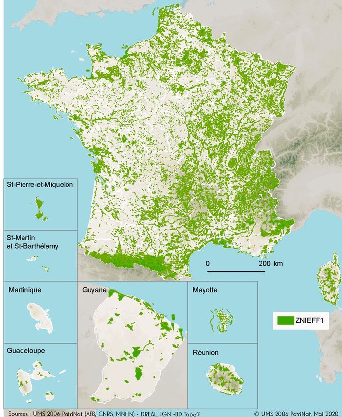
Figure 1.
Map of the Type I ZNIEFFs (continental and marine).
11Author-formatted, not peer-reviewed document posted on 14/07/2021. DOI:
https://doi.org/10.3897/arphapreprints.e71265
Figure 2.
Taxonomic coverage of the ZNIEFF inventory (number of taxa and data records per group) for
'taxonomic' groups that have more than 100 000 data records (the last download from INPN
took place on 26 May 2020).
12Author-formatted, not peer-reviewed document posted on 14/07/2021. DOI:
https://doi.org/10.3897/arphapreprints.e71265
Figure 3.
Taxonomic coverage of the ZNIEFF inventory (number of taxa and data records per order) for
insects (the last download from INPN took place on 26 May 2020).
13Author-formatted, not peer-reviewed document posted on 14/07/2021. DOI:
https://doi.org/10.3897/arphapreprints.e71265
Figure 4.
Taxonomic coverage of the ZNIEFF inventory (number of taxa and data records per group) for
'taxonomic' groups that have less than 100 000 and more than 1 000 data records (the last
download from INPN took place on 26 May 2020).
14Author-formatted, not peer-reviewed document posted on 14/07/2021. DOI:
https://doi.org/10.3897/arphapreprints.e71265
Figure 5.
Taxonomic coverage of the ZNIEFF inventory (number of taxa and data per group) for
'taxonomic' groups that have less than 1 000 data (the last download from INPN took place on
26 May 2020).
15Author-formatted, not peer-reviewed document posted on 14/07/2021. DOI:
https://doi.org/10.3897/arphapreprints.e71265
Figure 6.
Temporal distribution of the ZNIEFF dataset for species from 1757 to 2019.
16Author-formatted, not peer-reviewed document posted on 14/07/2021. DOI:
https://doi.org/10.3897/arphapreprints.e71265
Table 1.
Number of sites registered in the ZNIEFF inventory according to the different categories (May
2020).
Type I Type II Total
Continental ZNIEFFs 17 368 2 248 19 616
Marine ZNIEFFs 132 94 226
Total 17 500 2 342 19 842
17Author-formatted, not peer-reviewed document posted on 14/07/2021. DOI:
https://doi.org/10.3897/arphapreprints.e71265
Table 2.
Taxonomic coverage of the ZNIEFF inventory (species and subspecies) per ‘taxonomic’ groups
arranged in alphabetical order (the last download from INPN took place on 26 May 2020). The table
presents the number of records, the total number taxa, the number of endemic and subendemic
taxa and the number of taxa threatened on the national level according to the IUCN Red List
(threatened categories for IUCN: VU, EN and CR).
‘Taxonomic’ groups Number of Total Number of endemic and Number of threatened taxa (%
records number of subendemic taxa (% of the total of the total number of taxa is
taxa number of taxa is given in given in parentheses)
parentheses)
Animalia: 387 441 15 286
Amphibians 14 021 195 31 (15.9) 13 (6.7)
Annelids 1 276 242
Arachnids 8 766 875 24 (2.7)
Ascidians 205 49
Birds 153 047 1 503 44 (2.9) 261 (17.4)
Bivalves 1 444 208 1 (0.5)
Cephalopods 49 9
Crustaceans 3 990 607 99 (16.3) 45 (7.4)
Entognaths 369 98 73 (74.5)
Fish 13 567 1 128 41 (3.6) 28 (2.5)
Gastropods 5 489 575 85 (14.8)
Hydrozoans 289 70
Insects 144 237 8 823 412 (4.7) 52 (0.6)
Mammals 29 700 409 31 (7.6) 24 (5.9)
Myriapods 601 61 5 (8.2)
Nemerteans 7 3
Octocoralliarids 363 21
Plathelminthes 33 13 3 (23.1)
Pycnogonids 13 6
Reptiles 8 564 238 24 (10.1) 28 (11.8)
Scleractinian corals 1 411 153 14 (9.2)
Plantae: 600 220 15 616
Angiosperms 559 081 13 312 1 058 (7.9) 770 (5.8)
Chlorophytes and 574 122
Charophytes
Gymnosperms 3 071 89 2 (2.2)
Hepatics and 2 546 254
Hornworts
18Author-formatted, not peer-reviewed document posted on 14/07/2021. DOI:
https://doi.org/10.3897/arphapreprints.e71265
Mosses 12 017 809 1 (0.1)
Pteridophytes 21 291 765 64 (8.4) 120 (15.7)
Red algae 1 640 265
Fungi: 18 877 3 862
Fungus (without 15 149 3 033
Lichens)
Lichens 3 728 829
Chromista: 870 131
Diatoms 19 19
Ochrophytes 851 112
Supra-specific 6 317 889
taxa
TOTAL 1 013 725 35 784
19You can also read


