THE TOUR AOTEAROA (TA) 2020 - A LEAP INTO THE UNKNOWN - A BIKEPACKING ODYSSEY - MY STORY
←
→
Page content transcription
If your browser does not render page correctly, please read the page content below
THE TOUR AOTEAROA (TA) 2020 – A LEAP INTO THE
UNKNOWN – A BIKEPACKING ODYSSEY – MY STORY
How the journey started
My wife, Rhonda, and I were travelling north after touring the New Plymouth/ Taranaki
area on the North Island of New Zealand in our campervan and stopped for a coffee at
a café in a place called Mangakino. We got chatting with a fellow cyclist and his wife.
That was in 2018. It transpires he had just completed the TA2018 and was travelling
home. The TA (Tour Aotearoa - Aotearoa is the Maori word for New Zealand) is an
unsupported biannial 3000Km mixed terrain bike packing brevet ride. It starts at Cape
Reinga which is the most northerly point of New Zealand to Bluff which is the most
southerly point. Inspired by this conversation, the seed was sown and I had two years to
plan and prepare for the TA2020.
Planning and Preparation
Having been a road cyclist for most of my life the first challenge was to check out the
bike and kit requirements for this challenging bike-packing odyssey. A friend, Paul, of a
friend, Chris, who I had ridden with a couple of times rides a Sonder Camio Ti gravel
bike and spoke very highly of it. He also told me the bike was supplied by Alpkit who
could advise and supply pretty much all of the bike packing kit required to tackle the TA
ride. A visit to the Alpkit, Hathersage, store in Derbyshire, UK with Rhonda followed
shortly afterwards to seek advice from the very knowledgeable store staff and to check
out their bikes and bike-packing kit. A second visit with a friend, Peter, followed so that I
could test ride the Sonder Camio Ti gravel bike on some challenging off-road trails near
to the Hathersage store. On returning the bike to the store after the test ride I was
confident this was the bike for me and ordered the bike and kit there and then. A
significant bonus of our negotiation was Alpkit could deliver the whole consignment to
an address in New Zealand of my choice.
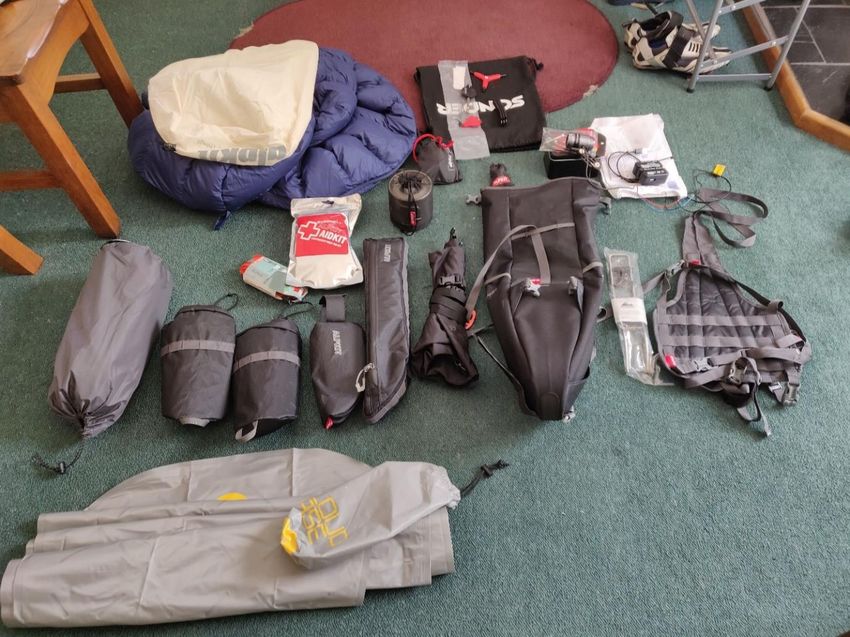
The bike and kit
The bike was specified as a medium size Sonder Camio Ti gravel bike frame with a
1X11 SRAM Force group set, hydraulic disc brakes, 650B wheels with hub dynamo and
Page 1 of 79
42mm tubeless tyres. The latest version (V3) of the Camio Ti frame with a few
modifications, including 'through axle' design, was shortly to be announced.
Working through the time-line, we had just enough time to wait for its relaunch and then
to be delivered to New Zealand in time. The initial bags selected were bar bag (Airlok
Dual 20L + Kanga harness), seat pack (Big Papa 17L + Exo-Rail), frame bag (Glider),
top tube bag (Fuel Pod 22) and two stem cells. The Hunt hub dynamo was selected to
power the lights or, via a control box, a usb output to charge all my essential electronic
gadgets needed for the trip. Other equipment bought from Alpkit included a one man
tent (Soloist), mattress (Cloud Base Titanium), sleeping bag (Pipe Dream 200
Hydrophobic), head torch (Qark), Ti mug (MytiMug), dynamo lights, first aid kit, drybag
(6L Jaffa) and gas burner (Kraku). The majority of riders had opted to ride mountain
bikes and carry full camping kit but a few, like me, had chosen to ride a gravel bike.
Some riders had decided to pre-book accommodation for the entire trip thereby
reducing the weight of their set-up but removing any flexibility on their ride schedules.

                                        Page 2 of 79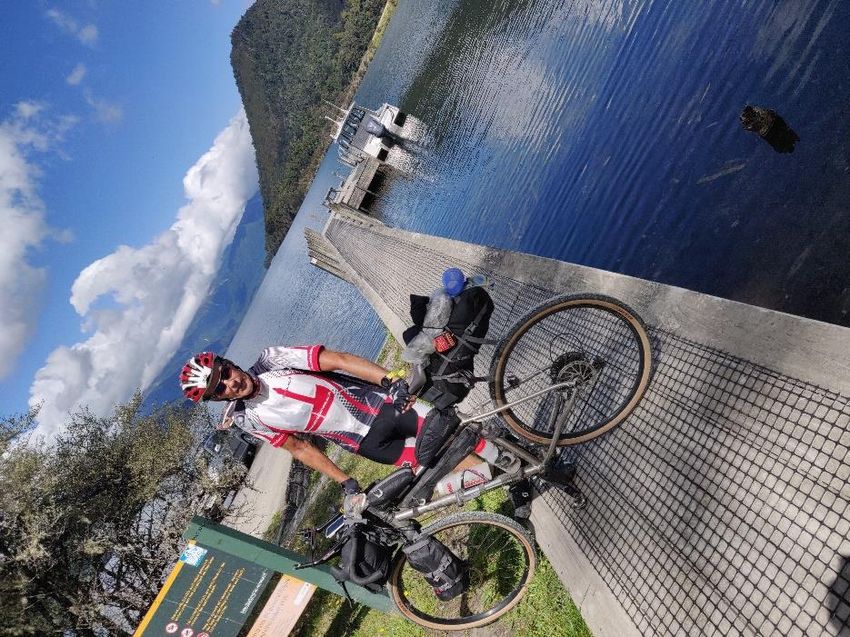
The navigation challenge
Although this was an unsupported event the course, verification requirements and
support information were provided by Messrs Kennett brothers. A guide book was
available as a pdf or as a paper copy; I opted for the pdf version and down-loaded this
to my phone to save weight! The main means of navigating however was by a Garmin
Edge 1030 which I bought specifically for the event. With the help of Messrs
Talkytoaster who specialise in installing digital maps for navigation on such devices, I
installed the New Zealand maps and downloaded the gpx files for the entire route. The
gpx files were provided by the Kennett brothers. This all looked fine when tested but in
practice proved to be a problem as the Garmin frequently told me I was off-course when

                                       Page 3 of 79
I wasn't, and often lost satellite signal. More on this later. I had also installed an App
(Orux) on my phone and downloaded the gpx files that would allow me to use my phone
to navigate in case of a Garmin failure. Deterred by the lack of a handle bar mount for
the phone, I didn't actually use it but, in hindsight, wonder if it might have been more
reliable at keeping on course.

Test Rides - in New Zealand
Alpkit had delivered the bike and all the kit I had ordered to New Zealand as planned to
coincide with our arrival in January. Given that the TA2020 wasn't until mid-February
this gave me time to do the final bike assembly, wire up the lights and control unit, add
the bags, organise a packing inventory                                  for each bag and
have a couple of multi-day test rides.                                  The first was a
three day test ride on the challenging                                  Waikato river trail
followed by a two day less challenging                                  test ride to our
son’s house north of Auckland. The                                      bike and kit
performed exceedingly well but I found                                  the geometry was
such that the two stems cells, whilst                                   providing useful
and convenient storage capacity,                                        impeded my ability
to ride out of the saddle. This would                                   later prove to be
essential on the TA ride itself. I                                      therefore decided
to replace these with a front folk bag                                  and an additional
top tube bag purchased by mail-order                                    from Alpkit. This
order included a spare gear hanger to                                   specifically to fit
the Sonder frame as this would be                                       difficult to replace
in case of damage on the ride. The                                      challenge now was
to get these parts to me in time. As a massive coincidence, I had discovered another
Brit, Hilary,                             and her partner, Phil, were not only planning to
do the ride but                           were to start on the same day as myself and,
even more                                 remarkably, they live in Hathersage. The
obvious                                   solution to the timing issue was for the pair to
bring these                               items out to New Zealand with them. This they
kindly did.                               Other than that the bike and kit proved to be a
great choice.                             The only other issue that arose was a crunching
in the bottom bracket on the second of my test rides which required the intervention of a
local bike shop in New Zealand to re-grease it.

                                        Page 4 of 79
The Ride Schedule
The TA Brevet has to be completed in 30 days or less (but no less than 10 days!). I
originally opted to take the full 30 days but then family requirements (a reunion in
Australia) meant I needed to reduce this to 27 days. I therefore planned a 25 day
schedule allowing two days of contingency in case of breakdowns, accidents or
inclement weather. So instead of averaging 100Km per day, to achieve the 25 day
schedule I now had to average 120Km per day. This didn't sound too challenging but
how I'd cope with riding a heavy fully loaded bike on mixed terrain was a big unknown
for me. I also wanted time to enjoy the riding and have time to stop occasionally to take
photos as well as the essential stops for food and drink.

The Start and Getting There
The logistics of getting to the                              start and back from the finish
is always one of the                                         challenges for these kind of
point-to-point endurance                                     events. I was delivered to
Auckland airport by Rhonda                                   after spending the night at a
nearby camping facility in our                               campervan. From here it was
a nine hour journey in a                                     shuttle bus towing a trailer
carrying our bikes.                                          Surprisingly, I knew a few
people on the bus; Hilary                                    and Phil from Hathersage.
Also, a couple of guys from                                  Albury in NSW, Australia,
James and Mark, who are                                      good friends with Ian, a good
personal friend from when he                                 and I worked together for
Mars in R&D. I sat next to a                                 really interesting guy called
John from Wanaka who had                                     lots of interesting stories to
share on the long drive to the                               top of the country.
The start at Cape Reinga was staggered over 21 days with approximately 80 riders
starting each day. Because the first day involved an 85Km section along 90 Mile Beach
it was necessary to do this during low-tide. This required that the start time be moved
forward an hour each day. The staggered start reduced the number of riders on the
course at one time thereby reducing the pressure points on accommodation and other
resources. My start time was 10am on 20th February which was the fourth wave to set
off out of 17. We arrived at Tapotupotu camping area at the top of the country by early
evening where I'd booked a re-erected tent with air-mattress and a barbeque meal.
Unfortunately the latter was very disappointing. Bike prepared for the off in the morning
and it was time to sleep.

                                        Page 5 of 79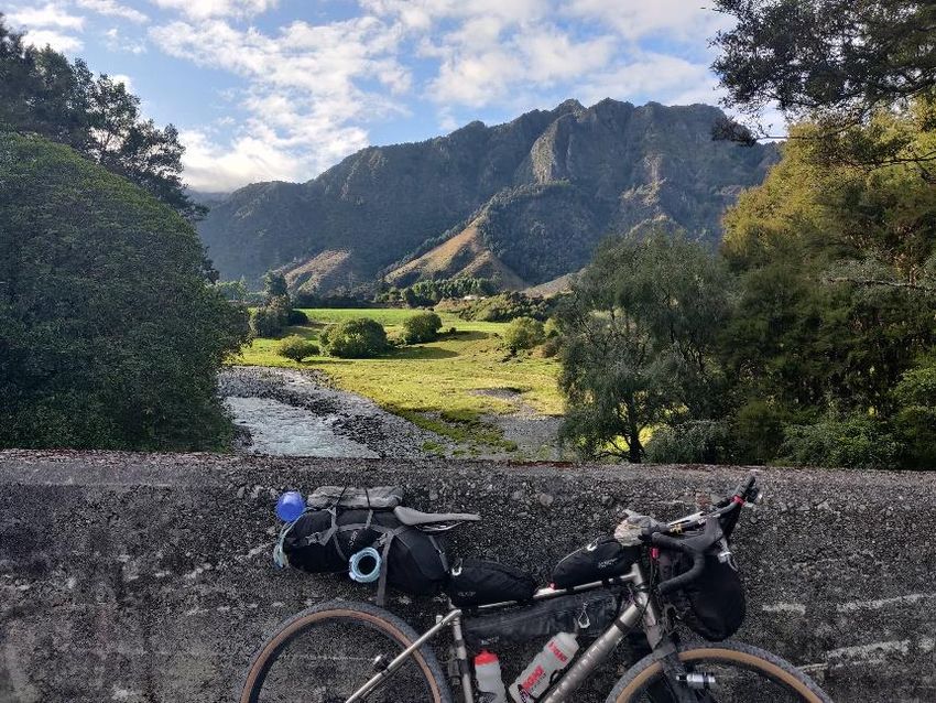
Data and Maps
For each day of ‘My Story’ I’ve included the data from my Garmin 937 Triathlon watch
(the power data should be ignored as this assumes my light weight road bike!). The
data shown has been copied from Strava which is a well-known App for sharing data
recorded for a variety of sports using a range GPS sports device. Also included is the
‘official’ distance covered per day as recorded by the MAProgress tracker. The maps in
‘My Story’ are taken for the Tour Aotearoa Official Guide (thanks Kennett Brothers) as
well as some hill profiles.

                                      Page 6 of 79
Day 1: Cape Reinga to Ahipara
                                    The Tapotupotu campsite was at the bottom of a
                                    long and steep gravel road. One of the more
                                    enterprising locals was offering a lift back up the hill
                                    to the start. This shuttle service proved to be quite
                                    popular, not least with me! A walk down from the
                                    drop-off point to the sign that marked the most
                                    northerly point and the direction to Bluff (!) and then
                                    to the 1st of 30 Photo control points. This was the
                                    Cape Reinga Lighthouse. Before setting off from the
                                    Cape car
                                    park we were
                                    provided with
                                    trackers by
                                    MAProgress
                                    which allowed
                                    anyone that
                                    was
                                    interested in
following our progress to do so through the
MAProgess app. Importantly, the trackers also
served as an emergency alarm; more on this later.
The clock counted down to 10am and we were set off. A short ride took us from the
Cape carpark on State Highway 1 (SH1) to a right turn onto the Te Paki Stream Road
which, were it not for bystanders yelling out, I would have ridden straight past; not a
good start! The Te Paki Stream Road was more of a sandy track and terminated at the
‘Giant Sand Dunes’ then continued on to the ocean as a sandy river trail. On the way
down the SH1 at the start I had my first encounter with Matt De from Sydney who I rode

                                         Page 7 of 79
with briefly to the river road. The trail, although
                                             beautiful, was more challenging than expected
                                             and I soon lost contact with Matt. For me, the
                                             river trail involved a combination of riding,
                                             walking and quite a lot of wading down the river
                                             until the trail
                                             met the
                                             ocean.
                                             What a
                                             relief, or so I
thought! A quick wash of the bike in the fresh river
water to remove most of the sand deposits then a
few photos on the beach. This was the 2nd Photo
                                     control point and a
                                     fellow rider obliged
                                     by taking obligatory photos. Now it was time to head
                                     due south on this remarkable and unique leg of the
                                     Tour. Initial feelings of jubilation and excitement
                                     subsided after a while as I settled into the 84Km grind
                                     on the beach which would take me all the way to my
                                     final destination for the day. A combination of a slight
                                     headwind and riding on sand made this a very
                                     challenging ride but was amazing nevertheless! On
                                     the way down I caught up with Matt again but, not
                                     really knowing him at this point, just said g'day as I
                                     rode slowly past. On arriving at the Ahipara Holiday
                                     Park at the southern end of
                                     90 Mile Beach, a bike
                                     washing station had been
                                     made available to help
remove that most abrasive of substances, sand, before more
damage could be done. Feelings of guilt due to an acute
water shortage in the Northland region soon gave way to
survival instinct and the need to preserve my machine for the
days ahead! Matt arrived at the campsite shortly after me and
we we're the first of the riders to camp here to pitch out tents.
                                        After pitching we
                                        proceeded to walk into
                                        the town for a very
                                        welcome fish and chip supper where we joined up
                                        with a number of other riders who had also made it
                                        this far on day one. This included another John
                                        (there were a lot of baby-boomers called John on
                                        this trip!) from Christchurch who was planning to
                                        ride on into the evening and pitch at the road side
                                        under the light of his head torch.

                                          Page 8 of 79
Tracker distance – 103.4Km

Day 2: Ahipara to Kahui
After the beach ride on the previous day, the 40Km of sealed road at the start of this
second days ride was most welcome. Before very long I caught up with Bruce from
Rotorua who I rode with for a short while until we turned off on to the first of many gravel
roads which immediately went up hill. Bruce is a fellow multi-sporter whose greatest
claim to fame was winning his age-group at the World Off-Road Triathlon
Championships in Canada a couple of years ago. Due to a combination of equipment
choice and experience a theme was already starting to emerge; I would be fine on the
sealed road sections but lose contact with experienced mountain bikers on the trickier
off-road sections. Having descended the last gravel hill on this trail we met the sealed
road again where I caught up with Matt and Bruce at the cafe in Kohukohu. Due to the
severe water shortage in this region we were unable to replenish our water supplies at
the cafe and had to rely on bottles water from the local convenience store. A short ride
then took us to the car ferry terminal at Rangiora and a 10 minute sailing across the
Hokianga Harbour to Rawene on the other side. The sealed road that followed went
through Opononi and climbed steeply up to a viewing point above Omapere where we
were treated to an amazing panoramic view over the ocean and harbour inlet. The
sealed road continued and include a number of challenging hills but we were rewarded
by views of stunning countryside as we approached the 3rd Photo control point at the

                                        Page 9 of 79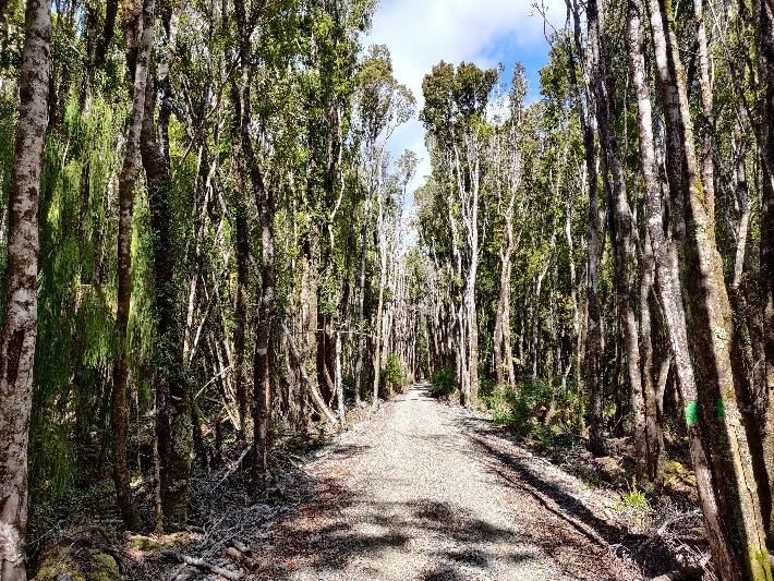
giant Kauri tree tourist hotspot. More food and drink was enjoyed from a roadside
purveyor whilst Matt caught up! Sadly, this show of dominance on the hills was short
lived! The mercury rose higher and higher as the day progressed adding to the
challenge. There was a gravel road from Waipoua to my campsite at the Kauri Coast
Holiday Park via the Trounson Kauri Park but I opted to take the longer but faster road
route. When I arrived at the campsite very hot and tired a very kind fellow camper in a
motorhome took pity on me and gave me the best cold
beer I've had in a long time. Unfortunately, the
campsite shop was somewhat bereft of food so
emergency provisions secreted away in my many bags
had suffice on this occasion. The campsites in New
Zealand invariably have camp kitchens and often have
cabins to hire as well as laundry facilities. I had my own
lightweight cooking equipment but wasn't able to take
gas on the shuttle to the Cape for insurance reasons
and hadn't managed to obtain one so far so the kitchen
facility was much appreciated. Matt arrived a little later
(after the beer donation) as he had taken the slower
gravel road option. I'd finished the day with a very sore
undercarriage; this would need careful management for
the entire ride to Bluff. Another big learning at this early
stage in the ride was the number of calories required
which was far higher than expected; quite a bonus if
one enjoys food as I do!

                                       Page 10 of 79
Tracker – 139.7Km
Day 3: Kahui to Helensville
The route started on a sealed road and I was expecting this to continue for nearly all of
this days ride to Pouto Point. I was wrong! Unbeknown to me, as I rode through the
town of Dargaville this was to be last point on the day’s ride where a cafe stop was
possible. Many other riders had realised this and relaxed in the town before embarking
on the long leg to Pouto Point. My Garmin was struggling to show me the correct route
out of Dargaville but a chatty elderly gentleman on an e-Bike came to my rescue and
escorted me a few kilometres on to and along Pouto Road. The road skirted alongside
the Wairoa River for next, and final, 70Km. With my hunger growing I fortunately came
across a Dairy (corner shop/ convenience store) where much needed food and drink
was purchased and consumed by the road side. Shortly after the road turned to gravel
and would take me all the way to the ferry pickup point at Pouto Point. The manual does
indicate how many kilometres of gravel to expect but I, along with everyone else,
discovered that there are many types of gravel road from fine to very coarse. Today it
was coarse! Note to self; check the ride manual for the day thoroughly before setting off!
I ended up arriving at Pouto Point four hours early for the ferry so, in the absence of any
shops, modest refreshments from the local campsite and a short swim in the estuary
followed. Surprisingly, this turned out to be my only swim for it the entire trip. My swim
goggles, which were dangling off the back of my rear bag, would cause much
amusement to fellow riders. Gradually, more and more riders started to arrive, amongst
Page 11 of 79them was John whom I had sat next to on the shuttle up to Cape Reinga. He had a
small amount of prescription nappy-rash cream which he generously allowed me apply
to my saddle sores. The Sudocrem I'd been applying in the mornings prove to be
ineffective at keeping these sores at bay. I'd had to ride long stretches of today's ride
standing on the pedals to relieve pressure on the saddle; thank goodness I'd dispensed
with the stem-cell bags earlier. The ferry arrived at 4pm on cue and was anchored to the
jetty-less sandy beach. It then took an hour to load the boat with bikes as they had to
man-handled by a human chain onto the top deck. This was the 4th Photo control point.
A pleasant three hour sailing across Kaipara Harbour eventually delivered us to the port
in Helensville in fading light. By the time we had man-handled the bikes off the boat the
daylight had completely deserted us. Bags re-attached to the bike, the next challenge
was to find Rhonda in the dark. She had set up camp in our campervan on a nearby
camping facility in Helensville and awaited my arrival. This was accomplished but it was
11pm by the time I’d had a good feed on Rhonda's yummy homemade chicken pasta,
fruit cake and flapjack.
Page 12 of 79Tracker – 144.3Km
Day 4: Helensville to Miranda
The alarm went off at the usual 6am and after a good night's sleep in the roof of our
campervan followed by a hearty breakfast I set off for a long day circumnavigating
Auckland, but not before I'd attended to my saddle sore issue. Rhonda had bought me
some special cycling 'bum' cream. I hoped this together with the application of blister
patches and wearing two pairs of shorts would help; time would tell. I'd planned to meet
Rhonda at the campsite in Miranda for another night of relative luxury in the campervan.
This allowed me to dispense with much of my bike-packing kit. On the way I was joined
on the ride at Riverhead by my son, Dan, and his two mates, Corey and Lewis, who
kept me company until it was time for them to turn off and return to their homes. In the
meantime I had a minor panic when I realised, thanks to Corey, I'd left my tracker in the
campervan. An urgent phone call to Rhonda led to a fortunate resolution to this
conundrum. We four riders would stop at a cafe known to Lewis whilst Rhonda drove
the route, tracker still emitting, whilst we feasted on coffee and cake until she caught up
with us. All good now and back on the road. After bidding farewell to my riding buddies,
I was alone once more as I navigated myself through Auckland to the 5th Photo control
point which was located at the top of Mount Eden. Here, amazing views over the City of
Sails could be enjoyed before descending again to do battle with countries most
populous cities traffic. Some of the route had cycle paths to keep us safe but not
enough. I later heard of a couple of encounters between rider and vehicle bringing their
rides to an unceremonious end. The route then passed through Cornwall Park (home of
one of the Auckland 5Km Park Runs) and on to Auckland Airport where lunch was
quickly scoffed. Shortly after this I was joined by another fellow cyclist who had done the
TA ride two years earlier. He was out for a local ride from his home and stayed with me
to Totara Park where, unfortunately, he punctured. A navigational error followed
resulting in an unplanned tour of the park on challenging gravel paths. There were two
Page 13 of 79'official ' route' options from South Auckland to Miranda. Both were very picturesque but
there were reports of heavy traffic on the beautiful coastal route due to a large festival
taking place. I therefore opted for the hillier inland route. I'd also ridden the coastal route
the opposite way on one of my previous test rides so thought it might be more
interesting to explore the inland route. This route took me past Ardmore Airfield where
we'd camped the night before the shuttle pick-up at the airport. As mentioned, a number
of challenging hills followed before the biggest surprise and highlight of the day; Rhonda
who had arrived at the Miranda campsite early had ridden out about 10Km to meet me
so we could finish the ride together. Miranda Holiday Park was very pleasant and is one
of the nicest sites we've stayed at on our many previous tours around New Zealand.
Other riders started to arrive and some were lucky enough to given a slice of Rhonda's
legendary flapjack.
Page 14 of 79Tracker – 153.6Km
Day 5: Miranda to Piarere
Another 'lightweight' day without a full bike-packing load. Today's plan; Rhonda was to
meet me at the end of the ride near to Piarere, to have a night in our own bed at home
in Cambridge, which was just a 20min drive away, then to be returned to where I'd left
off the next morning. So I set off down the coast road and joined the Hauraki bike path
that runs along the bottom of the Firth of Thames towards Thames. Thames is situated
on the south western corner entrance to the popular tourist area of the Coromandel
Peninsula. The route then continued onto the Hauraki Rail Trail which runs directly
south for a further c. 80Km's to Te Aroha. Again, I'd ridden this before in reverse on one
of my previous test rides so opted to ride on the quiet road that runs parallel to the trail.
The Rail Trail is flat and surfaced with course gravel so relatively slow going. The 6th
Photo control point was of dairy cows on the trail. Another reason for choosing the road
option was because I was to be met but a couple of cycling friends, Henk and Paul, who
had ridden out from Cambridge on road bikes to keep me company for the second half
Page 15 of 79of the ride. An unplanned benefit of this plan was we faced a significant head wind on
this section of the ride so I could benefit from drafting off the pair, especially Henk, all
the way to Matamata. I'd stopped earlier, before meeting the dynamic duo, for coffee
and customary scone in Paeroa but was now very much in need of further sustenance.
This was enjoyed along with the company of my riding companion’s right outside the
famous Hobbiton HQ. This was at the Information Centre in Matamata which was also
the 7th Photo control point. A relatively short fast ride to the junction with SH1 marked
the end of the ride and is where I'd arranged to meet Rhonda for a night of home
comforts.
Page 16 of 79Tracker – 139.4Km
Day 6: Piarere to Pureora
Another eventful day! The original plan was to say "goodbye" to Rhonda at the drop-off
point back near the Piarere SH1 junction expecting not to see each other again until I
returned from Bluff after completing the TA2020. However, much to my approval, we
decided that Rhonda would join me for one more night at a freedom camping area in
Pureora. This was just before the start of the infamous Timber Trail which would be
ridden the next day. More on this later. In the meantime I had to get there! Today’s ride
started with the relatively tame but beautiful Karapiro section of the Waikato River Trial
from Little Waipa to Arapuni where I met Rhonda again for coffee and cake at the very
popular Rhubarb Cafe. The Waikato River is the longest river in New Zealand and
actually flows past the bottom of our garden in Cambridge. In total, there are five
sections to the trail covering a total of 105Km. Two of these, the Arapuni and Waipapa
sections, I'd ridden on one day of a previous two day practice ride from Taupo but in the
opposite direction. These sections, which covered the trail from Arapuni to Mangakino
were book-marked by hydroelectric-dams with a third at the midway point at Waipapa.
I'd discovered these two sections of the trail to be particularly challenging on my
previous test ride, particularly on a gravel bike and involved a lot of walking! Much to my
relief, for the TA ride itself the Kennett brothers had included a road alternative for this
stretch in their manual. As it happens, the section from Arapuni to Waipapa was
Page 17 of 79temporarily closed. Remarkably, as I passed the trail exit onto the road near to
Mangakino Matt emerged having ridden the section from Waipapa. We then rode into
Mangakino and enjoyed another sustenance stop at the quirky Bus Stop cafe by the
lake. The route out of Mangakino initially followed the trail then on to SH30 and
continued up a short climb before dipping down to the Atataki Wire Swing Bridge. This
bridge had recently been repaired but had only a week or so before had threatened a
rerouting of part of the Timber Trail. The bridge itself was surprisingly challenging to
cross with fully loaded bikes and the initial part of the trail that followed was severely
rutted resulted in one of two riders taking a tumble and incurring minor injuries. This trail
provided access to the start of the Timber Trail at Pureora but before this, the trail
climbed again to over 800m to the 8th Photo control point; the 'Centre of the North
Island'. I'd arranged to meet Rhonda at Pureora and she had texted me to say she had
arrived. The problem was, when I arrived she wasn't there? I had arrived at a camping
area called Ngaherenga at Pureora where I met two more Ozzies, Rachel from Alice
Springs and riding partner Nathan from Broome who had decided to pitch up at this site.
I'd first met the pair briefly at the last Photo control point earlier on today’s ride. The
name of the campsite I had given to Rhonda was Pureora Campsite. It transpires
Pureora is the name the entire forested area and the campsite going by the same name
was at the midway point on the Timber Trail some 45Km of trail away. I'd given Rhonda
the wrong address! This problem was exacerbated by neither of us having a telephone
signal! Other riders I'd met along the way so far started to arrive and began to populate
the few cabins available for rent in the village. Well intentioned offers of a bed were
made but of course it was imperative that I made contact with Rhonda. To cut a long
story short, through a remarkably moment of serendipity, Rhonda made a WhatsApp
call using Wi-Fi at the Timber Trail Lodge at the same time as I happened to be passing
the only location where there was a mobile phone signal for miles. A one hour drive on
road and gravel later and we were reunited, very relieved and, in my case, very
apologetic! We set up camp in a field next to the cabins where Matt et al were to spend
the night and were able share their shower and toilet facilities.
Page 18 of 79Tracker – 120Km
Day 7: Pureora to Taumarunui
Another, and this time definitely final, pleasant night together in our campervan for the
TA ride and it was time to tackle the Timber Trail. However, before I left I'd mentioned to
Page 19 of 79Rhonda a lady in a neighbouring tent had suffered multiple punctured and seemed to be
in a broken state. In the end Rhonda gave her, her bike and all her kit a lift all the way
back to a bike shop in Cambridge. We never heard back from her after this encounter.
Being back to a fully loaded bike including camping kit added to the challenge on the
tricky 80Km off-road, mostly single track Timber Trail section. The first 10Km took riders
to the highest point on the trail before descending to Piropiro at the midway point. With
the exception of a Timber Trail Lodge and basic camping at Piropiro, there was
basically nothing but trail and bush between the start at Pureora and the finish of the
trail at Ongarue. After a very enjoyable but challenging ride to Piropiri I was desperate
for food so went straight to the lodge arriving at around 11am. The lodge had said they
would provide Pizzas for TA riders but unfortunately there was a notice on the door
saying not until 2pm! By this time it was baking hot so I sat in the shade and logged
onto the lodges WiFi using the logon code Rhonda had, fortunately, given me the day
before just in case I needed it. As I was WhatsApp messaging Rhonda, the Kevin and
Darryl duo who had started on the same day as me rolled up and managed to persuade
the chef to open early. What a relief! Food scoffed and it was time to tackle the second
half of the trail. Although mostly downhill the technical challenge and concentration
required still made this ride pretty tiring. On the way down the trail it went round the
Ongarue Spiral which was the 9th Photo control point. The spiral was built some 100
years ago to allow the original bush tramway to quickly gain or lose altitude and
comprises a low level bridge, a deep cutting, a curved tunnel to complete a circle of
track and onto a bridge. As I approached the village of Ongarue at the end of the trail
Kevin and Darryl caught up with me having the advantage of riding mountain bikes.
They also had significantly more experience of riding off road; not to mention our
differing approaches to risk management! As we joined the road at Ongarua we were
still together and rode most of the way to Taumarunui together. On arrival at the town I
dived into the first cafe I saw for more food, it
happened to be McDonalds? I enquired as to
the whereabouts of a campsite I'd found on my
campsite App (Rankers) and rode the 3Km or so
along SH4 to get there. Kevin and Darryl had
ridden past whilst I consumed the best food
McD’s could offer and had managed to hire
themselves a cabin for night. The Ozzy pair,
Nathan and Rachel, also arrived at the site and
had also decided to rent a cabin for the night. In
my case, with the sound insulation afforded by
my lightweight one-man tent competing with
trucks and trains for the whole night significant
sleep deprivation resulted. Taumarunui was the
last place we would have a mobile phone signal
until Pipiriki where I would arrive two days later.
Given that it was necessary to pre-book the
jetboat from the Mangapurua Landing down the
Whanganui River to get to Pipiriki this had to be
Page 20 of 79done before leaving town. I opted for and booked the 10am boat two days later.
Page 21 of 79Page 22 of 79
Tracker – 101.2Km

Day 8: Taumarunui to The Bridge to Nowhere/ Mangapurua Landing
This was expected to be a big day and, for a number of reasons, it was. A short ride
back into Taumarunui, a second breakfast at McDonald's and I was ready to get back
on the TA route. The sealed road quickly gave way to gravel as the route started a
300m climb and then descended to the Blue Duck Station (farm). The gravel road
through the station eventually led to a most amazing cafe going by the same name 'The
Blue Duck' at Whakahoro. This seemed to be quite incongruous in this isolated setting
but was very popular with riders and walkers navigating the trail. Matt and Bruce and a
few others had already arrived and were hoping to grab the last jetboat of the day so
scoffed down their fodder and set off ahead of me. Homemade lasagne and cake really
hit the spot but then the conversation turned to a dramatic occurrence from the day
before; a British doctor from Bath had slipped off the edge of the Kaiwhakauka Track
that awaited us after the cafe stop and had fallen down the bluff (cliff edge down to the
river below). The poor guy had to be lifted out by air-ambulance with a suspected
broken back. This was later confirmed and resulted in him being paralysed from the
waist down. As I tucked into the lasagne, a father (Bernard) and son (Jonathon) pair
with whom I'd been chatting set off from cafe. Minutes later they returned seeking help
with the Bernard’s puncture. This was duly provided but his tyre was badly damaged.
Nevertheless they set off again. I had always planned to be extremely cautious on this
notoriously tricky section but news of the accident made me even more careful. What
followed was a lot of dismounting, walking the tricky bits and remounting. I then came
across another casualty on the side of the track, this time a guy with suspected broken
ribs. When I arrived on the scene Nathan and Rachel were with him but there was very

                                       Page 23 of 79
little we could do; I later learned he and two other
riders had been airlifted out over the two day period,
two with broken ribs and one a fractured ankle. The
father and son pair came next, stranded on the side of
trail with that badly damaged tyre. This proved to be
unrepairable. Unfortunately, we were still 42Km (a
marathon distance!) from the jetboat pickup point.
They had no alternative but to walk it! The Bridge to
Nowhere was the 10th Photo control point and is
famous because it was built to take a road that would
link this remote valley to the River Boat that used to sail up the river. But, the road was
never built! I rode on with Nathan and Rachel with the intention of camping near to the
Bridge to Nowhere on the Mangapurua Track but access to water by this time in the day
was a prerequisite. In the end this only became available when we arrived at the end of
the trail where stream water could be accessed as it flowed down to the nearby river.
The Ozzy pair had a microfiltration system for such events which they allowed me to
use but I also boiled stream water on my camping stove. Tents pitched and stomach
filled, all in the dark using my head-torches, it was time to retire into my sleeping bag.
We thought we had the spot to ourselves but little did we know. First the father and son
pair arrived after their long walk, then more riders continued to appear out of the
darkness until about 9.30pm all of whom slept in bivvy bags under the small open
shelter. Two of them even went for a quick dip in the River before retiring for the night!
Matt and Bruce had managed to speed along the track and catch the last boat of the
day so spent the night at Pipiriki.
Page 24 of 79Page 25 of 79
Page 26 of 79
Tracker – 104.1Km

Day 9: Mangapurua Landing to Hunterville
The jetboat pickup point at the Landing where I'd camped was actually at the end of
trail, some 40Km's past the Bridge to Nowhere. Although I'd booked the 10am boat in
anticipation of camping further back on the trail I'd hoped I could blag my way onto the
earlier 8am boat. In practice, the wonders of the tracker and initiative shown by the
Whanganui River Adventures staff I didn't even need to ask; they had already allocated
me a slot on the 8am boat. As it happens, some clever loading of bikes and bodies
resulted in everyone that wanted to be accommodated on the boat. The 72Km jetboat
ride to Pipiriki that followed was nothing short of spectacular. Flat water followed by
turbulent rapids often lined with steep cliffs added to the excitement. On disembarking
at Pipiriki we were invited to indulge ourselves in a hearty complementary cooked
breakfast at the Whanganui River Adventures office. Needless to say we all obliged.
Their hospitality and support went even further as they'd also provided a comprehensive
bike cleaning station. This proved to be very useful after the ‘mucky’ ride the day before.
The office at Pipiriki was also the first of two Tracker battery swap locations. From here
we were treated to a scenic undulating sealed road for most the ride to Whanganui
where the river by the same name meets the sea. I rode part way with Bernard from
Mount Eden in Auckland until the hills got too much for him but we would meet up at

                                       Page 27 of 79
various points again subsequently. En-route the road passed through the historic village
of Jerusalem where there is a church and convent established in 1892 for the
congregation of the Sisters of Compassion. There is also a Maori Marae which was
located on the same site and offered accommodation to TA riders; sadly an overnight
stop here didn't fit my schedule. Shortly after Jerusalem the road climbed steeply again
to the top of Gentle Annie Hill and a viewing point over the beautiful valley below. By
this point Matt and Bruce had already passed through Whanganui a couple of hours
earlier. Matt kindly messaged me to recommend a very nice cafe near to the river
crossing in the town which turned out to be good advice. Refreshed again, I set off in
pursuit of the pair. A steep climb out of Whanganui took me to the 11th Photo control
point at Durie Hill Tower with amazing views over Whanganui. The tower was built in
1925 and is a memorial to those who died in WW1. Unaware until I arrived at the top,
there was a public elevator built c. 100 years ago for the residents of the Durie Hill area
that, had I known, would have saved my legs on the climb up to the tower! Having had a
late start to the days pedalling it was now late afternoon so I soldiered on alone to my
final destination of the day at Hunterville. On arrival in this very small town I came
across another rider ‘speed eating’ at
a corner cafe. A young chap that
seemed anxious to get pedalling again
despite it being the end of the days ride
for less ambitious riders like myself. I sat
and had quick chat with him before
moving the 100m or so up the road to
the Railway Station Hotel where I found the
now familiar collection of TA riders who
were already happily ensconced. I
managed to secure one of the last
remaining rooms which, by this time, was
subject to a slightly elevated rate
adjustment! I just managed a quick
shower and laundering of the few clothes
in time to order food at the bar before
they stopped taking orders; phew.
This was the first night I'd had the luxury
of hotel accommodation. Unfortunately it
seemed unprepared for the many TA
riders that would require their hospitality.
My room reservation, beer at the bar
and food order were all provided by one
barmaid who was literally running around
the hotel to service our needs, admiring
all with a sense of humour!
Tracker – 169.8Km
Page 28 of 79Page 29 of 79
Page 30 of 79
Day 10: Hunterville to Palmerston North
I'd ordered a full Kiwi breakfast the previous evening at the hotel but the message
hadn't got through from the overworked barmaid to the chef/ hotel owner. Undaunted, I
had my fill on cereals and toast before setting off with Matt to tackling the short climb
out of the town followed by the modest gravel climb up Vinegar Hill. Back on to a sealed
road as it started to drizzle with rain and on to Apiti where we stopped at the Tavern for
an early lunch of pizza. The pizza was liberally covered with camembert and was
accompanied with muffin and coffee. It was at this café I first came across a group of
riders from Queensland, Australia who had started the ride a day earlier than myself
and were travelling light by staying in hotels and lodgings.
From here the official route was 35Km on a gravel road to Pohangina but there was a
sealed road alternative so I decided to take it. This was slightly longer but was still
marked by 'official' cycle route signs indicating the way to Ashhurst. Unfortunately, the
sealed road then took me close, but not close enough for a photo, to the 12th Photo
control point at Totara Reserve. After this and just after Pohangina the two routes
merged again and the sealed road then continued through Ashhurst and onto
Palmerston North. Matt had messaged me earlier to advise me he had set up camp at
the Holiday Park in the town. I joined him and pitched my tent alongside. As I did so, a
succession of other riders including Kevin and Darryl, and Graeme from Blenheim
joined us. They had been able find our location using the tracker app. We were provided
with very generous pitches, each suitable for a large caravan and car. Our one-man
tents looked a little lost in these spaces. The town was very busy with a couple of
popular events taking place on this weekend including stock-car racing. Matt and I rode
into the town for food and shopping and more much needed blister patches for my
saddle sores!

                                       Page 31 of 79
Page 32 of 79
Tracker – 139.5Km

Day 11: Palmerston North to Martinborough
My early start was trumped by an even earlier start by Graeme who had de-camped and
set off before the rest of us had even emerged from our tents. At this point, we were
predominantly still riding as individuals and stumbling across each other at cafe stops
etc. en-route. This included setting off as individuals in the mornings. My day didn't start
well and finished in a similar fashion! I'd bought my Garmin Edge 1030 cycle computer
specifically for the TA2020 and was still on the lower slope of the learning curve in
mastering its functions! This day, I'd loaded in the gpx file for the segment I was already
on as usual but this time selected the option, 'Navigate to route' thinking this would
guide me from the campsite back on to the course. It didn't! After riding about 10Km's I
thought 'this doesn't feel right ', and it wasn't! The sun was rising to my right and Google
Maps confirmed I was heading north. I then realised my Garmin was talking me back to
the start of the segment! I doubled back and, with further help from Google Maps,
eventually got back on course. The sealed road then took me to the 13th Photo control
point, a giant Kiwi, at Eketahuna. This was also the first cafe stop of the day. More food
and chatting with fellow riders and it was time to head down to Masterton on a
combination of sealed and gravel roads. All good so far. Now for the last leg of the days
ride to Martinborough. A number of riders had struggled to find the route out of
Masterton and I was to suffer the same fate! After riding round in a few circles I stopped
at a garage and asked for help (and bought more food and drink). I was told to follow
the signs for SH2 and it would take me to the route. Although I doubted this, a couple of

                                        Page 33 of 79
TA riders went by and looked like they were going the way the garage attendant had
instructed. I duly followed but ended up off-piste on SH2 to Featherstone and then
needed to ride along the intended route but in the opposite direction to get to my
destination at Martinborough. I hadn't realised I was riding the route in the opposite
direction initially but then the penny dropped when I saw Bernard riding the opposite
way to me as I rode towards Martinborough. I knew from a previous conversation with
Bernard he was booked on the 2pm ferry across the Cook Straight to the South Island
the next day so he needed to get ahead of us.
As I rode up to the reception at the campsite Matt was already there and had kindly
booked a cabin for us to share for the night. Bruce arrived later with Kevin and Darryl
who also shared a cabin. Martinborough is a very pleasant little town adorned with a
number of trendy cafe, restaurants and bars which Matt, Bruce and I enjoyed after the
second longest day in saddle so far.
Page 34 of 79Page 35 of 79
Tracker – 157.8Km

Day 12: Martinborough to Wellington
Matt went to a bakery in town and had breakfast whilst I had porridge at the campsite. I
then joined him before setting off together in the direction of the Remutaka Rail Trail
some 27Km away. The first part of the ride on a sealed road took us back towards
Featherstone thereby retracing the end of the previous day’s erroneous ride. The sealed
road then morphed into a cycle track at Cross Creek and the start of the Remutaka
Trail. This was initially a single track path more suited to mountain bikes. On arrival at
this trail we came across a small group of riders who had started the TA a couple of
days before us and were, sensibly, taking the ride leisurely and smelling the
metaphorical roses as they went. The single track soon became less demanding as it
met the more open and wider disused railway track that would take us c. 7Km to the top
of the Remutaka Summit at c. 350m and the tunnel. The Remutaka Summit Tunnel was
the 14th Photo control point. The track then continued through a number of further
tunnels, across a suspension bridge and down the long decline to Upper Hutt. By this
time we were in desperate need of more calories. I nice cafe offering TA riders free
coffee was eventually found in Stokes Valley. We arrived just as it started to rain. Food
and two coffees later the rain had ceased so it was back on our bikes. The flat cycle
path that followed took us to the outskirts of Wellington. We stopped to take photos

                                       Page 36 of 79
across Wellington harbour and as we remounted our bikes were caught by three guys
who were on a more ambitious schedule. We had plenty of time in hand before our 4pm
sailing but couldn't resist hitching a ride and slipstreamed the trio to the ferry terminal.
They were staying with friends and had booked themselves onto a later early morning
boat the next day. Wellington was at roughly 1600Km from Cape Reinga so we were
now a little over half way to Bluff. As we checked in at the Interislander ferry terminal
imagine my surprise when I bump into the cycling friend, Paul (and his with Roie), from
Cambridge who, with Henk, had kept me company on the leg from Miranda to Piarere
on day five. They were heading down to Wanaka for the Motatapu mountain bike race.
'All-aboard', bikes secured on the lowest deck on the boat where the trains usually go
and a group of us, including Paul and Roie, commandeered a suitable seating area near
the bar! As we sat enjoying the first extended period of relaxation since leaving Cape
Reinga on this 92Km crossing to the South Island Kevin appeared with some small
items of memorabilia for each of us. In my case, he had bought me a decorative
teaspoon; something to do with me being an English tea drinker I believe! What a
thoughtful gesture that was. Not wanting to risk losing this precious item of cargo (or
carrying extra weight?) Roie kindly offered to be custodian until we all returned to
Cambridge. Little did we know at the time that Covid-19 would delay when the spoon
and I would be reunited. After a very pleasant crossing augmented by spectacular views
as we manoeuvred into Marlborough Sounds we arrived at the South Island ferry
terminal at Picton. But, before disembarking a photo on the ferry was required as this
was the 15th Photo control point. By now it was 7.30pm so it seemed prudent to find
somewhere suitable for food in the town before the short ride to a local campsite. After
our group had been fed and watered in one of the towns hostelry’s we rode the short
distance to the local campground where Matt again managed to negotiate a good price
on a shared cabin for the three of us.
Page 37 of 79Page 38 of 79
Page 39 of 79
Tracker – 95.44Km

                    Page 40 of 79
Day 13: Picton to Richmond
We set off individually from the campsite as and when we were ready to roll. First up, a
challenging climb out of Picton onto the amazing Queen Charlotte Drive. I'd driven this
beautiful road a number of times before but had never ridden it. Spectacular roadside
views over the harbour gave way to gorgeous panoramic views over the Sounds as the
road twisted, turned and undulated its way to Pelorus Bridge. By the time I arrived at the
cafe at this tourist hot spot it had started to rain so a good time to shelter, eat and drink.
This was also the second point on the TA where we did a Tracker battery swap. On
previous visits to this beauty spot I'd managed to squeeze in a bracing swim in the river.
Not this time! As I was finishing my pie, cake and coffee, a bedraggled Matt et al
arrived. Never to miss an opportunity, he had taken an optional small gravel road
detour. At this point I had a big decision to make; the 'official' TA route went off road for
much of the section between Pelorus Bridge and Nelson onto the Maungatapu Track
and over the Maungatapu Saddle which was also the 16th Photo control point. Much
was being made of how challenging parts of this ride would be, especially when it's wet
and if not riding a mountain bike. I knew the longer
road route to Nelson well and recalled it had some
challenging hills in it. It is also a route frequented
by logging trucks which sometimes pass by
frighteningly close. On balance, I decided the road
option was as challenging in a different way to the
off-road route but, for me, the safer choice. On
arriving 'safely' in Nelson I headed for the
Information Centre where I could pick up the
official TA route again. On my way into the town I
called our friends Martin and Justine who, like us,
live half the time in the UK and half in New
Zealand. I'd arranged to meet up with Martin on
the Great Taste Trail near to Nelson and ride back
with him to his motorhome at Richmond. Having
accomplished this, bikes loaded and a short drive
later we arrived at their beautiful house in Mapua
where I was treated to the most amazing, and
much appreciated, hospitality. Not only that,
Martin was able, and kind enough, to loan me a
number of the items I'd lost on the way south on
the North Island.
Tracker – 209.1Km (including Cook Straight crossing)
Page 41 of 79Page 42 of 79
Day 14: Richmond to Murchison
Well rested, fed, watered and clothes laundered Martin and I returned to the point where
we'd left the route on the previous afternoon to start the days ride, but not before Martin

                                       Page 43 of 79
had filled my crossbar snack bag with his awesome homemade flapjack. I salivate just
thinking about it! Back on the Great Taste Trail and on to Wakefield where I had trouble
finding my way out of the town and back onto the trail. Having eventually accomplished
this and happily riding along the trail my Garmin kept telling me I was off course again
and to do a U-turn. I'd learned to ignore many of these instructions as my Garmin had
already proved to be quite unreliable but uncertainty crept insidiously into my mind.
Eventually I gave into doubt and turned around and started riding back from whence I'd
come. Fortunately, I soon met the two guys we'd slipstream behind into Wellington who
assured me I was going in the right direction in the first place! I tagged on to this speedy
pair until we reached the famous 1.4Km long Spooners Tunnel where I had a brief
photo stop. All available lights on to ensure safe passage through the tunnel then
onwards. Surrounded by hops farms the road continued on to Tapawera for my first
cafe stop of the day. A combination of sealed and gravel roads followed cresting the
Tadmor Saddle at a little under 500m the route then taking me on to the 17th Photo
control point at Lake Rotoroa. I was delighted to rendezvous again with Martin at the
lake side and relax in his motorhome for a short break. What a godsend this was, not
least because we could escape the infamous Nelson Lakes sandfles whilst we enjoyed
tea and more flapjack together. The remaining 40Km to Murchison started with a short
but challenging rough gravel climb on the Braeburn Track to the Braeburn Saddle after
which there was a long, mostly gravel, track to Murchison where I’d arranged to meet
Martin again. He had set up camp on the NZMCA (New Zealand Motor Caravan
Association) camp ground in the town. Imagine my surprise, again!, when I discovered
Kevin and Kerryn, who I ride with on a weekly basis back in Cambridge, were not only
camping in Murchison whilst on a touring holiday but also on the same NZMCA site.
Having showered then chatted with Martin as we feasted on Justine’s chilli con carne,
hot-cross buns and tea it was time to retire for the night.
Page 44 of 79Page 45 of 79
Page 46 of 79
Tracker -144.8Km

Day 15: Murchison to Reefton
A comfortable night’s sleep in Martin's motorhome, a hearty breakfast and flapjack
stocks replenished, it was time to bid our final farewells and see if I could reconnect with
Matt and Bruce who, by now, had already set off from their accommodation in
Murchison. The sealed road out of town led to a right turn onto the Maruia Saddle Road
which was a gravel climb up to 580m at the saddle itself. This was the 18th Photo
control point so a brief photo stop was in order. Back on to a sealed road after the
gravel descent into Maruia then more gravel riding to Springs Junction where a much
needed stop to refuel at the Springs Junction Cafe was needed before continuing on to
my final destination of the day at Reefton. This mostly downhill stretch was on a sealed
road through lovely native forest but not before an initial climb up to Rahu Saddle at
700m. On arriving at Reefton I bumped into Bruce who had arrived only a few minutes
before me. A quick coffee together in the Broadway Tearoom then off to the local Motor
Camp which was conveniently situated only a short walk away from the main street.
Here, we managed to hire another shared cabin for the night. Reefton is an interesting
town not only because of its gold heritage whereby gold was extracted from gold
bearing quartz reefs, but also because it can boast being the first town in the southern
hemisphere to supply municipal electricity to the area. Commissioned in 1888, the
remains of the original hydro-electric station are still a tourist attraction today. Once
ensconced at the campsite, Bruce and I walked back down the main street in pursuit of
food and beer. Bruce fancied Thai food and after much deliberation we settled on the
Dawsons Hotel where we both ordered a Thai chicken curry. The beer was good but
sadly the food wasn't and didn't come close to satisfying our voracious appetites. The
solution, more food from the local Four Square supermarket! But where was Matt? We

                                        Page 47 of 79
later learned he had arrived earlier than us and decided to continue on and overnight at
the 'Big River Hutt' on The Waiuta Big River Track.
Page 48 of 79Page 49 of 79
Tracker -120Km

Day 16: Reefton to Lake Kaniere
This day started with yet another                            decision on road vs track, this
time to Greymouth. Actually, after                           reading the TA guide book,
this was quite an easy decision for                          me; it said "This 5-7 hour
stage is challenging, especially                             after wet weather. Cycle
tourists should bypass along                                 Highway 7". Decision made,
‘Hard-man’ Bruce and I parted                                company for the day as he
took the track option. By this time                          on the TA ride the mornings
were getting quite chilly and made                           a little less comfortable for the
early part of the ride by light rain. I                      wasn't the only one that had
decided to take the 'low-risk' option                        to Greymouth. On the short
climb out of Reefton I caught up with one of the Ozzy couples from Queensland, Guy
and Mary, who were also on gravel bikes and had made the same decision. Further
down the road I stopped at convenience store/ bakery in Ikamatua for a short break and
to shelter from the rain. As I did so, Guy and Mary caught up. As we chatted over coffee
they told me how they had been first on the scene back on the Kaiwhakauka Track
(route to Bridge to Nowhere) where the British guy had fallen and broken his back
several days earlier. They had in fact pressed the emergency button on the tracker on
his bike which was, fortunately, still on the track and hadn’t followed him off the bluff.
Seeing their photos of the guy being winched out by helicopter confirmed how important
it is ride safely and within your own and your bikes capability. By now the rain had
stopped. From Ikamatua the route turned off Highway 7 and onto a nice smaller road
into Greymouth. On the way I'd spotted another rider in the distance who I eventually
caught up with at the McDonald's in Greymouth (yes, I know!, buts it’s a quick and
cheap way of scoffing down the calories – and they always have WiFi). He was also on
a gravel bike. Guy and Mary had accommodation booked in Greymouth so had to call it
a day at this point. The rest of their Queensland group, who were on mountain bikes,
were doing the longer and slower Big River route and so would arrive in Greymouth
later in the day. Unfortunately, anyone taking the road
option missed the 19th Photo control point at the
boardwalk on the Waiuta Track. The next Photo
control point for us, the 20th, was at Greymouth Bar
Lookout. The route then joined the start of amazing
West Coast Wilderness Trail which extends some
139Km from Greymouth down to Ross. Today though
I would ride the trail as far as Lake Kaniere.
Consisting of mostly gravel roads and tracks, this trail
was one of the many highlights of entire ride. A pot of
Yorkshire tea at a cafe in Kumara was a very pleasant
surprise and I had nice chat with young German lady
who was cycle touring the South Island. Refreshed
and back on the trail, over the Kawhaka Pass then
onto and through a couple of challenging river
crossings. I later heard of another mishap on one of

                                         Page 50 of 79
these crossings whereby a rider called John from Australia had lost
his footing, slipped, fractured his tibia and had his bike and gear
washed 900m downstream. His bike was later recovered from the
river by a doctor and fellow mountain biker called Katie from the
Greymouth Hospital where he was airlifted to after a cold a wet night
in the bush.
I eventually arrived at the infamous Cowboys Paradise. As the name
suggests, this was a collection of quirky cowboy saloon styIe
buildings accessible only on the track and populated primarily by
organised groups on e-Bikes. I arrived here late in the afternoon and had intended this
to be where I'd spend the night. Unfortunately, there was 'no room at the Inn' and the
slightly obnoxious proprietor wouldn't allow me pitch my tent in his grounds! A pie, a
cold drink, and a chat with a nice couple from Queenstown later and I had no choice but
to continue riding down the trail to the Arahura River which led me to Lake Kaniere
where there was a very nice but basic campsite. By now it was getting late so tent
quickly erected and food prepared. Fortunately, I had sufficient provisions with me to
cook up a simple meal.
Page 51 of 79You can also read