Traffic Committee Meeting - Business Papers
←
→
Page content transcription
If your browser does not render page correctly, please read the page content below
BUSINESS PAPER
                                        13 July 2021

                 Traffic
                 Committee
                 Meeting
                 Tuesday 13 July 2021
Traffic Committee meeting                                                                        13 July 2021

                                       TRAFFIC COMMITTEE
              Notice is hereby given that a Traffic Committee meeting of Randwick City Council
                              will be held on Tuesday, 13 July 2021 at 9:30am

COVID-19
IMPORTANT NOTICE: In order to protect the health of members of our community, the representatives of
other agencies and Council staff members, during the COVID-19 pandemic, the Traffic Committee
meetings are being undertaken as remote meetings - using MS Teams. The meeting starts at 9.30am.

Any members of the community, wishing to make representations regarding a matter listed within the Traffic
Committee Agenda, must email the Council (council@randwick.nsw.gov.au) at least 24 hours prior to the
meeting. Details on how to join the meeting would then be provided.

Traffic Committee
The following information is provided so that you may be aware of the structure and operation of the
Randwick City Traffic Committee.
-    The Randwick Traffic Committee is a Committee of Randwick City Council but not one set up under
     the Local Government Act.
-    Council has been delegated certain powers, from Transport for NSW (TfNSW), with regard to traffic
     matters upon its local roads. A condition of this delegation is that Council must take into account the
     Traffic Committee recommendations.
-    Recommendations in this document may either activate the formal delegation from Transport for NSW
     to the Council, or not activate this delegation. Items which activate the delegation are indicated with
     the initials (AD) below the heading.
-    There are four permanent members of the Traffic Committee, each of whom has a single vote only.
-    The members are: the NSW Police Service, Transport for NSW, the Local State Member of
     Parliament (for the location of the issue to be voted upon) and Randwick City Council.
-    Randwick City Council welcomes the public to attend and speak at its Traffic Committee on issues of
     concern.
-    If the Local Member disagrees with any of the Traffic Committee recommendations, they may appeal
     to Transport for NSW or the Minister for Roads.
-    If the Police or Transport for NSW disagrees with any of the Traffic Committee recommendations, or
     Council’s resolution on any Traffic Committee recommendation, they may lodge an appeal with the
     Sydney Regional Traffic Committee for determination. The appeal must be lodged in writing within 14
     days of the notification to the members of Council’s decision on the recommendation.
-    Any action relative to any issue under appeal must cease until the matter is determined.
-    The Sydney Regional Traffic Committee is chaired by an independent chairperson and submissions
     and representations are welcomed from all interested parties.

                                            Randwick City Council            1300 722 542
                                            30 Frances Street                council@randwick.nsw.gov.au
                                            Randwick NSW 2031                www.randwick.nsw.gov.au
Traffic Committee meeting                                                                                                           13 July 2021

Acknowledgement of Country
The Chair will ask for a volunteer to acknowledge the lands upon which this meeting is being held:
         “I would like to acknowledge that we are meeting on the land of the Bidjigal and the Gadigal
         peoples; being the traditional owners who, for thousands of years, occupied and cared for vast
         areas along the Sydney Coast.
         On behalf of the participants of this meeting I acknowledge and pay my respects to the Elders
         past, present and emerging, and also to those Aboriginal people participating today.”

Attendance and Apologies
Declarations of Pecuniary and Non-Pecuniary Interests
Matters Arising from the Minutes OR from Council Resolution

Items for Consideration
At this time the Chair will ask those present at the meeting to nominate those items about which they
would like some discussion or elaboration.
The Recommendations on all other items, not so nominated, will then be put to the Committee for
endorsement.

Traffic Committee Reports
TC102/21       Bundock Street, between Elphinstone Road and Hendy Avenue, South Coogee (C) ........ 4
TC103/21       King Street, at Alison Road, Randwick (C).......................................................................... 5
TC104/21       Rainbow Street, Randwick (C) ............................................................................................ 7
TC105/21       St Thomas Street, at Boundary Street, Clovelly (C) ............................................................ 8
TC106/21       Brompton Road, Kensington (H) ....................................................................................... 10
TC107/21       Ainslie Street, Kingsford (M) .............................................................................................. 11
TC108/21       Anzac Parade, at Franklin Street, Malabar intersection (M) ............................................. 12
TC109/21       Anzac Parade, north of Fitzgerald Avenue, Maroubra (M) - State Road .......................... 13
TC110/21       Anzac Parade, Maroubra Junction (M) .............................................................................. 14
TC111/21       Bass Street, at Anzac Parade, Kingsford (M).................................................................... 17
TC112/21       Duncan Street, Maroubra (M) ............................................................................................ 18
TC113/21       Wild Street / Donovan Avenue, Maroubra (M) .................................................................. 19
TC114/21       Minor Signage Items - Parking and Regulatory - July 2021 (C, H & M) ............................ 21
TC115/21       Works Zone - Installation and Removal of Signage - July 2021 (C, H & M) ..................... 24
TC116/21       Parking Control Signage at Intersections - No Stopping - July 2021 (C, H & M) .............. 27
TC117/21       Federal Stimulus Road Safety Program Zones Projects (C, H & M) ................................ 28
TC118/21       Transport for NSW (TfNSW) Funded Project Status - July 2021 (C, H & M) .................... 31
General Business

                 (C) Coogee Electorate               (M) Maroubra Electorate                 (H) Heffron Electorate

                                                                                                         Tony Lehmann
                                                                                       MANAGER INTEGRATED TRANSPORT
Traffic Committee meeting                                                                         13 July 2021

 Traffic Committee Report No. TC102/21

 Subject:           Bundock Street, between Elphinstone Road and Hendy Avenue,
                    South Coogee (C)

      Index code     Trim Ref:   Category         Sub Category                    By    AD
      2021.07.102    D04222668   Road Safety      Warning sign                    DA    Yes

An analysis of the Transport for NSW (TfNSW) provided crash data, between July 2015 and June 2020, for
Bundock Street between Elphinstone Road and Hendy Avenue, South Coogee, reveals that four crashes
have occurred at this section of road. Two of these crashes were due to the vehicles crossing to the wrong
side of the road and two were ‘off carriageway to object crashes (RUM Code 73).

Three of the crashes were characterised by vehicles travelling east and one was travelling west with three of
the crashes occurring in dry conditions and one was in wet conditions; two of the vehicles were characterised
by over-speeding.

It is considered that chevrons and curve warning signage and “Reduce Speed When Wet” signage should
be installed on the north eastern corner and south western corner of Bundock Street (as shown in the Figure
1), South Coogee. This would alert motorists to proceed with caution around the bends and travel at a safer
speed.

                                   Figure 1 - 118 Bundock Street, South Coogee

 Recommendation

 That chevron markers and Slippery When Wet warning signs are installed on approach to the bends
 near 118 Bundock Street, Randwick, to alert motorists to the road conditions.

Responsible officer:        Dilruba Akhter, Transport Engineer

File Reference:             F2015/00395
Traffic Committee meeting                                                                        13 July 2021

 Traffic Committee Report No. TC103/21

 Subject:           King Street, at Alison Road, Randwick (C)

 Index code     Trim Ref:   Category               Sub Category                     By     AD
 2021.07.103    D04218593   Signage Regulatory     No Right/No Left Turn            NN     Yes

Concerns have been raised by the Police, regarding a large number of vehicles turning into Alison Road,
from King Street, Randwick. The King Street slip lane is an ‘STA & Authorised Vehicles Excepted’ One
Way access, from Alison Road into King Street.

The following signage is proposed to improve safety and adherence of the One-Way restriction at King
Street, Randwick.

                                   Location of signs on ELP

 Recommendation

 That:
Traffic Committee meeting                                                                          13 July 2021

      1. ‘No Left Turn’ and ‘No Right Turn’ signs are installed back-to-back, on the electric light pole
         (ELP) at the intersection of the Alison Road slip lane and King Street (as per the tabled
         diagram), to alert King Street motorists of the one way conditions applying to the slip lane; and

      2. a right arrow pavement marking is installed on the King Street slip lane, north of the pedestrian
         crossing, to further delineate the traffic direction.

Responsible officer:        Nafisa Nishandar, Student Transport Engineer

File Reference:             F2004/07249
Traffic Committee meeting                                                                         13 July 2021

 Traffic Committee Report No. TC104/21

 Subject:           Rainbow Street, Randwick (C)

 Index code     Trim Ref:    Category         Sub Category                            By    AD
 2021.07.104    D04226535    Pedestrian       Pedestrian Safety                       TL    Yes

Traffic and Parking Issues near Rainbow Street Public School

Following consultation with the Parents and Citizens Association from Rainbow Street Public School, a
number of issues have been referred to the Traffic Committee for consideration.

Below is a summary of these matters, with a relevant response:

1. Extension of existing Rainbow Street Kiss and Go zone adjacent to Paine Reserve

    Rainbow Street is not managed by Randwick Council as it is a state road and is managed by Transport
    for NSW (TfNSW). The Council has no objection to a 36m westerly extension of the existing No
    Parking, 8:00am-9:30am, 2:30pm-4:00pm, Monday to Friday, “Kiss and Go” zone. Accordingly, a
    request will be forwarded to TfNSW, for it to consider such an extension.

2. Installation of double yellow lines to make three point turns across Rainbow Street illegal.

    Rainbow Street is not managed by Randwick Council as it is a state road and is managed by Transport
    for NSW (TfNSW). The Council has no objection to TfNSW considering the installation of double
    separation lines along this part of Rainbow Street. Accordingly, a request will be forwarded to TfNSW,
    for it to consider such a facility.

3. Cars turning right from Paton Street onto Rainbow Street is unsafe as they push their way in front of
   those turning from Rainbow Street into Paton Street; and students need to cross Paton Street with no
   access to any form of safe crossing.

    An examination of the most recent crash data indicates that this intersection is performing well, from a
    road safety perspective. Observations have indicated that there is, from time-to-time, localised
    congestion. However, such congestion necessitates that motorists travel at relative low speeds.
    These low speeds reduce the likelihood of any incidents occurring and reduce the level of trauma if an
    incident does occur. Accordingly, it is recommended that a Right Turn ban not be installed at this
    intersection.

4. Increased volumes of traffic due to cars turning right from Rainbow Street to get through to Barker
   Street as turning right onto Anzac Parade at the old roundabout is no longer an option.

    Throughout Sydney there is a general increase in traffic flow over the years. Rainbow Street is a state
    arterial road connecting two other state roads (Anzac Parade and Avoca Street). It will always carry a
    significant amount of traffic. A better explanation is required of the concerns which have been raised.

5. Young Street /Fennelly Street
    a. The width of the installed footpath does not enable parents, prams, or students to walk together.
       People are unable to walk two abreast. Safety recommendations suggest children should hold
       their parents’ hands until 10 years old but there is no capacity to do this due to the width of the
       footpath.
    b. There is no verge – the footpath runs adjacent to the kerb. If anyone steps off the footpath they
       are on the road.
    c. The corner where Young Street becomes Fennelly Street is a blind corner for cars due to the
       fence installed by the developer right up to the gutter and apex of the corner.
    d. No pedestrian crossing access for students who need to access the western side of Young Street
       and other streets off Young Street to the west.
    e. Stage 2 construction of the Newmarket site will increase traffic, pedestrians and construction
       vehicles thus posing increased risk to pedestrian safety.
    f. Stage 2 of the development will lead to increased traffic in the area as residents access their
       homes via Young and Fennelly Streets.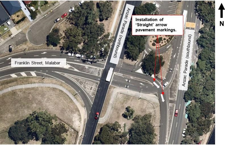
Traffic Committee meeting                                                                       13 July 2021

      g. Young/Fennelly Street is being used by cars to bypass the lights at Barker and Botany Streets
         (used as a rat run).

    The road layout of Young Street and Fennelly Street has been installed in accordance with the
    approved development plans. Additionally, Fennelly Street is not yet a public road and is not in
    Council’s control. Accordingly, the Council cannot, at this time, undertake any action upon Fennelly
    Street. However, an examination of the approved road layout and possible improvements (including a
    widening of the southern footpath) will be undertaken.

6. Speed limit is not 40km/h as per areas around schools

    Speed limits on public roads are not managed by Randwick Council. Speed limits are managed by
    Transport for NSW (TfNSW). The Council will make representations to TfNSW seeking implementation
    of a 40km/h School Zone speed limit, for the rear of the school, in parts of Young Street and Fennelly
    Street.

7. Previously there was a Kiss & Drop zone on Young Street prior to the construction of the Newmarket
   development

    The previous informal arrangement was an ad hoc situation whereby parents delivered children to the
    cul-de-sac end of Young Street. If the school is in agreeance, the Council would support the
    installation of a 55 metre “Kiss and Go” zone along the southern side of Fennelly Street (from the
    school gate to the driveway opposite Jane Street.

8. The following items have also been raised by the P&C Association and can be discussed at the Traffic
   Committee meeting
    a. a Kiss and Go program operated by the school
    b. a set of signals at Botany and Rainbow to control the flow of traffic
    c. more pedestrian crossings (the two outstanding on Sturt have been earmarked for a few years)
    d. Council to record the volume of traffic on the streets I earmarked in our list to Council last
         October to see whether they justify a pedestrian crossing, or at the very least, a pedestrian
         refuge on those streets, including Paton Street
    e. a red light/speed camera, or otherwise, to increase safety for pedestrians using the Rainbow
         Street signalised pedestrian crossing, as raised in recent years by the P&C Association.

 Recommendation

 That the items detailed within the report be discussed at the Traffic Committee meeting.

Responsible officer:        Tony Lehmann, Manager Integrated Transport

File Reference:             F2008/00166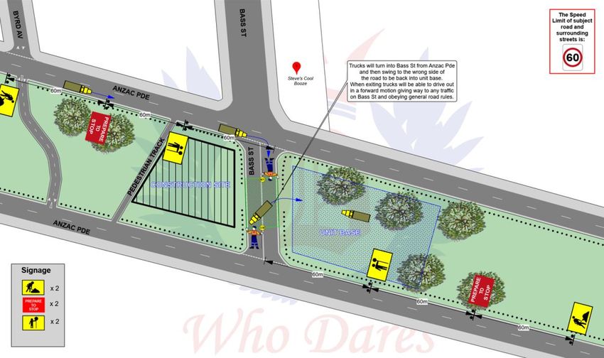
Traffic Committee meeting                                                                         13 July 2021

 Traffic Committee Report No. TC105/21

 Subject:           St Thomas Street, at Boundary Street, Clovelly (C)

 Index code       Trim Ref:        Category         Sub Category                    By    AD
 2021.07.105      D04218348        Line marking     Lane Lines                      NN    Yes

A resident has requested for the installation of a Mobility Impaired Person’s Parking Space (MIPPS) at St
Thomas Street, Clovelly. St Thomas Street between Boundary Street (west) and Boundary Street (east) is
a 9.5m wide, two-way street with unrestricted kerb side parking on both sides of the street. In recent times
the resident has had trouble finding parking close to their property. The property does not have any off-
street parking space, the resident is the owner of a TfNSW-issued mobility card and consequently qualifies
for the MIPPS application.

Currently, a length of 50m double barrier (BB) line separates the carriageway on St Thomas Street,
between the two Boundary Street alignments. The road width is such that there is less than 3m statutory
clearance between the BB line and the proposed MIPPS location.

It appears that the BB lines act as a form of lane delineation more than regulating the overtaking movement
at this location. Hence it is proposed that BB lines only be installed on St Thomas Street at the approach of
Boundary Street and Boundary Street East. Lane lines are also proposed to be installed for a length of 28m
between the BB lines as illustrated in the image below.

This would enable installation of the MIPPS (see Minor Signage table - Item TC114/21.13) at the frontage
of 87 St Thomas Street, Clovelly, without vehicles being parked within 3m of the BB lines.

 Recommendation
Traffic Committee meeting                                                                     13 July 2021

 That the proposed combination of BB and broken lane line be installed at St Thomas Street, between
 Boundary Street (west) and Boundary Street (east), Clovelly.

Responsible officer:        Nafisa Nishandar, Student Transport Engineer

File Reference:             F2004/07441
Traffic Committee meeting                                                                      13 July 2021

 Traffic Committee Report No. TC106/21

 Subject:           Brompton Road, Kensington (H)

 Index code           Trim Ref:     Category       Sub Category                   By     AD
 2021.07.106          D04203417     Pedestrian     Marked Foot (Zebra) Crossing   RM     Yes

Requests have been made to the Council to install No Stopping signs near an existing pedestrian crossing
in the Raleigh Park Estate at Brompton Road, near Black Lion Place. It is noted that the pedestrian
crossing does not meet the current Australian Standards of AS1742.10-2009 as it has yellow and black
pavement markings. The current standard is black and white pavement markings.

 Recommendation

 That the existing pedestrian crossing in Brompton Road, near Black Lion Place, Kensington, with the
 yellow and black pavement markings be updated to the traditional black and white markings to meet the
 current AS1742.10-2009 standard.

Responsible officer:        Rasheeq Mahmood, Transport Technical Officer

File Reference:             F2004/07455
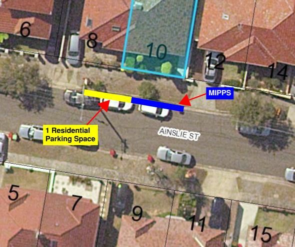
Traffic Committee meeting                                                                                 13 July 2021

 Traffic Committee Report No. TC107/21

 Subject:           Ainslie Street, Kingsford (M)

 Index code     Trim Ref:        Category          Sub Category                                By   AD
 2021.07.107    D04232315        Signage Parking   Mobility Impaired Person’s Parking Space    RM   Yes

The Council has received a request from the resident of 10 Ainslie Street, Kingsford, seeking a 6.5m
Mobility Impaired Person’s Parking Space (MIPPS) in front of their property. The MIPPS applicant does not
have an off-street parking space. The applicant has a residential parking permit holder for Area KF4, and
the nearest residential parking zone is directly in front of their property which is always occupied.

The requested 6.5m MIPPS will be located at the current residential parking restricted zone (“2P, 8:00am-
6:00pm, Mon-Fri, Permit Holders Excepted, Area KF4”). 6.5m of the zone needs to be replace with 6.5m
MIPPS at the frontage of 10 Ainslie Street as no other resident in Ainslie Street has a residential parking
permit besides the resident of 10 Ainslie Street.

                            Existing                                                Proposed

 Recommendation

 That:

      1. A 6.5m Mobility Impaired Person’s Parking Space (MIPPS) be located directly in front of 10
         Ainslie Street, Kingsford, commencing at the property boundary of nos. 10 and 12 Ainslie Street
         and terminating 6.5m west of the property boundary of nos. 10 and 12 Ainslie Street; and

      2. Remove a 6.5m residential parking restricted zone (“2P, 8:00am-6:00pm, Mon-Fri, Permit
         Holders Excepted, Area KF4”) from the property boundary of nos. 10 and 12 Ainslie Street and
         to 6.5m west of the property boundary of nos. 10 and 12 Ainslie Street, Kingsford.

Responsible officer:            Rasheeq Mahmood, Transport Technical Officer

File Reference:                 F2009/00452
Traffic Committee meeting 13 July 2021
Traffic Committee Report No. TC108/21
Subject: Anzac Parade, at Franklin Street, Malabar intersection (M)
Index code Trim Ref: Category Sub Category By AD
2021.07.108 D04252777 Linemarking ‘Straight arrows’ on roadway NN Yes
Concerns have been raised by a resident regarding the perception of traffic direction while crossing Anzac
Parade (southbound) and Franklin Street intersection. Given the existing stop sign control, southbound
motorists turning right into Franklin Street (west) are obliged to stop and wait for traffic flowing east from
Franklin Street onto Anzac Parade (southbound) to pass before proceeding further. The geometry of the
intersection is such that southbound right turning motorists may perceive that slip lane ahead of them is
southbound. If this is the case, the right turn motorists may not perceive that they have to yield to traffic
from the right. In order to address this false perception the following arrow markings are proposed to
ensure correct travel movement is maintained.
Figure 1 - Anzac Parade, at Franklin Street intersection
Recommendation
That ‘Straight’ arrow pavement markings be installed in front of the ‘Stop (TF)’ line on Anzac Parade
(southbound) at the Franklin Street intersection, as illustrated in Figure 1.
Responsible officer: Nafisa Nishandar, Student Transport Engineer
File Reference: F2004/07441Traffic Committee meeting 13 July 2021
Traffic Committee Report No. TC109/21
Subject: Anzac Parade, north of Fitzgerald Avenue, Maroubra (M) - State
Road
Index code Trim Ref: Category Sub Category By AD
2021.07.109 D04218518 Signage Parking No Stopping NN Yes
Notwithstanding the fact that Anzac Parade is a state road under the care and control of Transport for NSW
(TfNSW), it is considered that the following matter should be discussed at Traffic Committee prior to a
formal request being placed before TfNSW. It is noted that the TfNSW representative may be unable to
endorse any recommendation arising out of this item.
Concerns have been raised by a local resident regarding pedestrian access to and from the central median
Anzac Parade car park, between Fitzgerald Avenue and Haig Street, Maroubra. In particular, it has been
noted that the existing kerb ramp on the western side of the northbound Anzac Parade carriageway
(outside no. 863) is regularly blocked by parked cars. In order to keep the kerb ramp clear and to provide
safe visibility for pedestrians crossing at this location, it is proposed that ‘No Stopping’ signs be installed as
shown in the plan below.
Proposed ‘No
Stopping’ signs.
N
Kerb ramp for
pedestrian access to
No. 863 and from carpark.
Existing Bus Zone.
Recommendation
That Council seek the approval of Transport for NSW (TfNSW) for the implementation of a 20m long ‘No
Stopping’ prohibition, on the western side of Anzac Parade, from the existing pram ramp (outside no 863)
southerly.
Responsible officer: Nafisa Nishandar, Student Transport Engineer
File Reference: F2004/07433Traffic Committee meeting 13 July 2021
Traffic Committee Report No. TC110/21
Subject: Anzac Parade, Maroubra Junction (M)
Index code Trim Ref: Category Sub Category By AD
2021.07.110 D04245988 Road Safety Road Safety AL Yes
A post-construction Road Safety Audit (RSA) was undertaken in March 2021, for the newly installed
pedestrian fence along the western side of Anzac Parade, frontage of Maroubra Junction shopping centre
known as Pacific Square. The pedestrian fences were installed by Transport for NSW (TfNSW) in an attempt
to reduce the number of pedestrian collisions occurring in this area. This item is to report on the findings of
the RSA.
The objective of this RSA is to identify and report on any potential road safety issues that may pose a risk
to road users, such as pedestrian, cyclist and motorist. This audit was carried out under the Austroads ‘Guide
to Road Safety - Part 6: Road Safety Audit 2009’ by auditors accredited by the NSW TfNSW. The general
audit location is Anzac Parade, between Boyce Road and Maroubra Road, Maroubra.
Below are the findings of the report;
1. Indiscriminate Pedestrian Movements
The auditors observed high volumes of pedestrians indiscriminately crossing Anzac Parade away
from the designated signalized crossings at the Boyce Road and Maroubra Road intersections
(Picture 1.1). Furthermore, the pedestrian activity was observed to be constant, occurring during
breaks in the traffic, or whilst traffic was queuing back from the nearby traffic signals. Pedestrians
crossing randomly across the road is considered a vehicle-pedestrian crash risk. Given the nature
of Anzac Parade, this is considered a high risk.
The auditors observed that a large proportion of the pedestrians crossing could be considered a
heightened risk (elderly, heavily laden with shopping), who may move at a slower pace, increasing
their exposure to oncoming traffic, and further heightening the risk (Picture 1.2).
Observations revealed that the main desire line for pedestrians was to and from the Maroubra
Junction Shopping Centre, either linking to the central car park, or the southbound bus stop on the
eastern side of Anzac Parade.
Picture 1.1 Picture 1.2
2. Car Park Pedestrian Access Points
The auditors observed that some indiscriminate crossing was directed to and from the pedestrian
access points adjoining the central median car parking area (Picture 2.1).
It was observed, that some of these access points had been blocked off by a rail to prevent access
between the car park and the adjacent footpath along Anzac Parade (Picture 2.2). It is assumed
that the rails were installed to reduce the occurrence of pedestrians crossing at midblock locations
adjacent to these accesses, and to direct them to the nearby signalised crossings.Traffic Committee meeting 13 July 2021
That being said, it was obvserved that the rails at some locations has been removed and the access
points were being heavily used by pedestians. Additionally, more capable pedestrians were simply
stepping over or under the single rail to use the access points.
Picture 2.1 Picture 2.2
3. Car Park access - vehicle entrance and exit
The auditors observed that some indiscriminate crossing was directed to, and from, the existing car
park vehicle exits, resulting in pedestrians walking along the access road (Picture 3.1). This provides
pedestrians with opportunity to cross Anzac Parade away from the signalised intersection.
The auditors comment that this has the heightened risk of collision between vehicles exiting the
carpark, and pedestrians attempting to cross Anzac Parade who may be concentrating on the Anzac
Road traffic.
Picture 3.1
4. Bus stops
The auditors note that there are two northbound bus stops along the western side of Anzac Parade
and one southbound bus stop on the eastern side.
The auditors observed that a large proportion of pedestrians who were crossing Anzac Parade were
heading to the bus stops (Picture 1.1). This is considered high risk behaviour as it often results in
pedestrians crossing unsafely in front of, and behind buses. Furthermore, the auditors observed
pedestrians, at times, rushing across Anzac Parade, running in front of the bus and waving their
hands to catch the attention of the driver in order not to miss a bus which was stopped at the stop.
This is considered high risk activity that could result in a pedestrian-bus collision, or pedestrian-
vehicle collision due to reduced visibility or due to the pedestrian being distracted trying to wave
down the driver and not paying attention to oncoming traffic.
Whilst the Audit team have tried to separate out individual items for discussion as per the above, it should
be expressed that the common risk shared by all items is large volumes of pedestrians are crossing unsafely
for the length of Anzac Parade, and not utilising the signalised intersections. Thus, simply addressing
individual aspects may not result in significant safety improvements and all issues should therefore be
considered in conjunction with an area wide solution considered.Traffic Committee meeting 13 July 2021
Given the finding of the RSA above, it is evident that despite TfNSW installation of the new pedestrian fence,
pedestrians are still crossing Anzac Parade indiscriminately. It is recommended that a more elaborate and
an area wide solution is required to resolve the issue of pedestrian and vehicle conflict on Anzac Parade,
between Boyce Road and Maroubra Road.
It is worth noting that Anzac Parade is a State Road under the care and control of TfNSW, and under the
strong influence of the NSW Movement and Place Framework, TfNSW have a strong desire to satisfy the
need of pedestrian safety in this area. As such, Council seeks to work closely together with TfNSW regarding
this matter.
Recommendation
That:
1. The Road Safety Audit (RSA) findings undertaken in March 2021, for the newly installed
pedestrian fence along the western side of Anzac Parade, near the frontage of Pacific Square,
be noted, and
2. The Council further liaise with Transport for NSW (TfNSW) to quickly address the road safety
concerns at this location and, in the medium term, consider an area-wide solution to the issue of
pedestrians crossing Anzac Parade onto the central car park area and vice versa, between
Boyce Road and Maroubra Road, Maroubra.
Responsible officer: Alexander Lin, Transport Engineer
File Reference: F2020/02312Traffic Committee meeting 13 July 2021 Traffic Committee Report No. TC111/21 Subject: Bass Street, at Anzac Parade, Kingsford (M) Index code Trim Ref: Category Sub Category By AD 2021.07.111 D04258216 Event Temporary Road Closure AL Yes Council received an application for a Filming/Photography activity on Bass Street, at Anzac Parade, Kingsford, which in part, included the periodic stopping of traffic for no longer than 2 minutes at a time, on Friday 25th June 2021, between the hours of 7am-11am. Traffic control was requested by the applicant to allow for safe manoeuvres of vehicles reversing into the median. Accordingly, a Traffic Guidance Scheme (TGS) was created and submitted to Council for approval, as shown below. Due to the time constraints, the approval for the submitted TGS has been given. This item is a retrospective record of this minor event. Recommendation That it be noted that minor traffic control was implemented within the Bass Street link road of Anzac Parade, on Friday 25th June 2021, between the hours of 7am-11am. Responsible officer: Alexander Lin, Transport Engineer File Reference: F2012/00032
Traffic Committee meeting                                                                                 13 July 2021

 Traffic Committee Report No. TC112/21

 Subject:           Duncan Street, Maroubra (M)

   Index code         Trim Ref:         Category         Sub Category                       By      AD
   2021.07.112        D04217107         Road Safety      Speeding                           DA      Yes

Concerns have been raised from some residents of Duncan Street, Maroubra, regarding instances of
vehicles speeding through Duncan Street between Torrington Road and Bond Street, Maroubra.

Speed and traffic counts were undertaken on 5 March 2021, for a seven-day period, to determine the extent
of the speeding issue. The counts were installed at the vicinity of 62 Duncan Street.

The results of the counts are summarised in the tables below:

                                                                              Direction of Travel
                 Duncan Street near No.62
                                                                 Combined        Northbound      Southbound
 Traffic Volume:                   Weekdays Average                   1262           630              632
 (Vehicles/Day)                    7 Day Average                      1260           625              635
 Weekday                    AM     8:00                                122           59               63
 Peak hour
                            PM     17:00                                118           63                  55
 starts
 Speeds:                           85th Percentile                     45.3          44.4             45.8
 (Km/H)                            Average                             35.4          35.4             35.2
                                   % of vehicles > 50 km/h             5%           4.1%             5.8%
 Speed %:
                                   % of vehicles > 60 km/h             .3%           .4%              .3%
 Classification % :                Light Vehicles up to 5.5m          94.21         92.82            95.57

The data highlights that the average daily traffic volumes are low and the traffic speeds are considerably well
below the 50km/h speed limit. The instances of motorists travelling at speeds over 50km/h is 5%.

 Recommendation

 That:

      1. The results of the traffic survey for Duncan Street, Maroubra, undertaken in March 2021, be
         noted; and

      2. The resident raising concerns about this matter be informed of the results.

Responsible officer:             Dilruba Akhter, Transport Engineer

File Reference:                  F2012/00032
Traffic Committee meeting 13 July 2021 Traffic Committee Report No. TC113/21 Subject: Wild Street / Donovan Avenue, Maroubra (M) Index code Trim Ref: Category Sub Category By AD 2021.07.113 D04258581 Road Safety Intersection NN Yes Concerns have been raised from several residents of Wild Street and Donovan Avenue, Maroubra, regarding safety at the intersection. The intersection currently has regulatory Stop signs installed on Wild Street, giving priority to Donovan Avenue. Donovan Avenue provides an east-west connection between Hinkler Street and Paine Street, and is along the 316 (Eastgardens to Bondi Junction) bus route. Wild Street provides a north-south link between Maroubra Road and Fitzgerald Avenue. On-street parking is permitted on both sides of Wild Street and Donovan Avenue. It is worth noting, that Wild Street, being in proximity to Heffron Park, experiences increased traffic during weekends due to the sporting activities at Heffron Park. Residents have reported numerous near misses to have occurred at the intersection over the years. Recently three crashes between May 2021 - June 2021 involving towing away of vehicles was observed and reported by the residents. The 10-year crash history reflects three crashes to have occurred between 2010-2020, of which two involve an injury and one that resulted in tow-away of vehicle. The intersection does not meet the criteria for 2022- 23 Black-spot funding as there are less than three injury crashes at the location in the past five years. The cross-traffic near misses/crashes are mainly due to motorists not adhering to the Stop sign at Wild Street. In order to address safety concerns and improve visibility of the approaching intersection an upgrade to line-marking, installation of additional Stop signs and No Stopping signs is proposed as illustrated in the plans below.
Traffic Committee meeting                                                                         13 July 2021

 Recommendation

 That:

      1. The double barrier (BB) lines are installed on Donovan Avenue for 10m, on approach to the
         intersection;

      2. Supplementary Stop signs are installed on the western and eastern side of Wild Street;

      3. No Stopping signs are installed at all four corners of the intersection for a minimum of 13m on
         Wild Street and Donovan Avenue; and

      4. Re-painting of current double centre linemarking (BB) at Wild Street is undertaken on both sides
         of the intersection.

Responsible officer:        Nafisa Nishandar, Student Transport Engineer

File Reference:             F2019/01152
Traffic Committee meeting 13 July 2021
Traffic Committee Report No. TC114/21
Subject: Minor Signage Items - Parking and Regulatory - July 2021 (C, H & M)
Index code Trim Ref: Category Sub Category By AD
2021.07.114 D04217129 Signage, Parking No Parking NN Yes
The following Minor Signage matters are listed for the Committee’s consideration.
Recommend
Item No Location Issue Request Comments
Approval?
To maximise
Install No Parking sign on the
Brandon Street, sightlines to and
south side of Brandon Street
CLOVELLY (C) from
from the western edge of the
TC114/21.1 (D04217129, Yes pedestrians
driveway to no.17 westerly to
D04229924-NN) walking past
the Electric Light Pole (ELP)
(AD) this section of
SY15368.
Brandon Street.
To alert
Brandon Street, Install ‘Pedestrian (symbolic)’ motorists to
CLOVELLY (C) warning sign at ELP SY15368 possible expect
TC114/21.2 (D04217129, and SY15369 at eastern and Yes pedestrians
D04229924-NN) western approach of Brandon walking along
(AD) Street, Clovelly. this section of
Brandon Street.
Change the “P15 Minutes To encourage
8am-6pm Mon-Fri” and “1P frequent turn
Brook Street,
TC114/21.3 8am-6pm Sat-Sun” signs at the overs and allow
COOGEE (C) (ITD- Yes
frontage of 120 Brook Street, motorist to park
RM) (AD)
Coogee NSW 2034 to “1P close to local
8am-6pm Mon-Sun”. amenities.
Install approx. 10m of “2P, To
Carr Street, 8am-8pm, Mon-Sun, Permit accommodate
TC114/21.4. COOGEE (C) Holders Excepted, Area CO2” for the increase
Yes
(D04261368-AL) zone on the southern side of in resident
(AD) Carr Street, between the parking permits
driveways of no.8 & no.10. issued..
Install approx. 14m of “2P,
8am-8pm, Mon-Sun, Permit To
Carr Street, Holders Excepted, Area CO2” accommodate
TC114/21.5. COOGEE (C) zone on the northern side of for the increase
Yes
(D04261368-AL) Carr Street, from the driveway in resident
(AD) of no.19 easterly to the existing parking permits
No Stopping sign near the issued..
Mount St intersection.
Implement No Stopping zone To prevent
Centennial Avenue, along the existing 3.5m length vehicle parking
TC114/21.6 RANDWICK (C) of yellow linemarking, in front illegally on the
Yes
(D03664723-AL) of no.2B, at the inner bend, bend of
(AD) between the two tangent points Centennial
of the curve in the kerb. Avenue.Traffic Committee meeting 13 July 2021
Recommend
Item No Location Issue Request Comments
Approval?
Henry Street, Remove 5.5m Mobility
Applicant no
TC114/21.7 RANDWICK (C), Impaired Person’s Parking
Yes longer resides
(D04228149-NN) Space at the frontage of 25
at this address.
(AD) Henry Street, Randwick.
Extend existing “2P, 8am-6pm,
To
Mon-Fri, Permit Holders
Monmouth Street, accommodate
Excepted, Area RA6” on the
TC114/21.8 RANDWICK (C) for the increase
eastern side of Monmouth Yes
(D04263053-AL) in resident
Street, Randwick, outside nos
(AD) parking permits
1 to 7, 15m southerly, to the
issued.
driveway of no. 11.
Extend existing 60˚ Mobility To assist
Impaired Person’s Parking nearby eligible
Nolan Avenue,
Space (MIPPS) at the frontage mobility
TC114/21.9. CLOVELLY (C)
of 15 Nolan Avenue, Clovelly Yes impaired
(D04256470-RM)
NSW 2031 by an additional resident park
(AD)
2.9m west at the frontage of close to their
11A Nolan Avenue, Clovelly. property.
To assist
Install 6m Mobility Impaired
Rainbow Street, eligible mobility
Person’s Parking Space
RANDWICK (C) impaired
TC114/21.10 (MIPPS) directly in front of 201 Yes
(D04195799-RM) residents park
Rainbow Street, Randwick
(AD) close to their
(near Canberra Street).
property.
Parked car at
Extend the existing No
Rainbow Street, this steep
Stopping sign located on the
COOGEE (C) location of
northern side of Rainbow
TC114/21.11 (D04249790-DA) Yes Rainbow Street
Street up to the eastern edge
(AD) causing safety
of the driveway of 20 Dundas
issues for the
Street, Coogee.
motorists.
3m gap
Dundas Street,
Grind off (black out) 3m of BB required
COOGEE (C)
line marking in Dundas Street between the
TC114/21.12 (D04249790-DA) Yes
situated at the frontage of 21A parked vehicle
(AD)
Dundas Street, Coogee and the BB line
at this location.
To assist the
St Thomas Street, Install 6m Mobility Impaired mobility
CLOVELLY (C) Person’s Parking Space impaired
TC114/21.13 Yes
(D04230681-NN) (MIPPS) at the frontage of 87 resident park
(AD) St Thomas Street, Clovelly. close to their
property.
Wentworth Street, Remove Mobility Impaired
Applicant no
RANDWICK (C) Person’s Parking Space
TC114/21.14 Yes longer resides
(D04188443-RM) (MIPPS) at the frontage of 94
at this address.
(AD) Wentworth Street, Randwick.Traffic Committee meeting 13 July 2021
Recommend
Item No Location Issue Request Comments
Approval?
Relocate “No Parking - Council
Current car
Authorised Car Share” signage
Goodwood Street, share bay
from 3 -5 Goodwood Street to
KENSINGTON (H) needs to be
TC114/21.15 8 -10 Goodwood Street (90⁰ Yes
(D04266181-BS) relocated due to
angle parking outside the 7
(AD) upcoming
Eleven at 110 Anzac Parade,
works.
Kensington).
To assist the
eligible mobility
Install 12m Mobility Impaired
Holmes Street, impaired
Person’s Parking Space
MAROUBRA (M) residents of the
TC114/21.16 (MIPPS) at the frontage of 142 Yes
(D0422906-NN) two adjacent
and 144 Holmes Street,
(AD) properties to
Maroubra.
park close to
their homes.
To assist
Maroubra Road, Install 6m Mobility Impaired eligible mobility
MAROUBRA (M) Person’s Parking Space impaired
TC114/21.17 Yes
(D04213948-RM) (MIPPS) directly in front of 361 residents park
(AD) Maroubra Road, Maroubra. close to their
property.
Recommendation
That the recommendations listed in the Minor Signage items table, are approved for implementation /
action.
Responsible officer: Jai Sue, Administrative Support - City Services
File Reference: F2012/00032Traffic Committee meeting 13 July 2021
Traffic Committee Report No. TC115/21
Subject: Works Zone - Installation and Removal of Signage - July 2021 (C, H
& M)
Index code Trim Ref: Category Sub Category By AD
2021.07.115 F2021/00658 Signage Works Zone Yes
Construction sites often involve the use of trucks, cranes and other large vehicles. Without special parking
provision, the positioning of such vehicles, close to these sites, can cause significant problems for local
residents or businesses. It is for this reason that the Council requires the creation of Works Zones at
construction sites. Once the project is completed the Works Zone is removed (see Works Zone Conditions
of Use detailed elsewhere within this document).
Accordingly, it is recommended that Works Zones be installed, or removed, at the locations detailed within
the following table:
Works Zones Table
Item No.
Length
Side
Adjacent to Existing Parking Reference /
(m)
Street/ Suburb
(address) Controls Comments
INSTALLATION
LA/1347/2021
D04248265-AL
(AD)
Install ‘Works
1. Aeolia Lane, 39 St Pauls Street
N 7 No Stopping Zone, 7am-5pm,
RANDWICK (C) (rear access)
Mon-Fri, 8am-
5pm, Sat” and
“No Stopping, All
Other Times”
LA/1414/2021
2. Dutruc Street, 46 Dutruc Street,
W 10 Unrestricted D04261075-DK
RANDWICK (C) Randwick NSW 2031
(AD)
LA/979/2021
3. King Street, 30-36 Dangar Street
N 10 Unrestricted D04203328-RM
RANDWICK (C) / 100 King Street
(AD)
D04257168-DK
(AD)
Install temporary
4. Barker Lane,
S 31 2B Barker Street Unrestricted Works Zone
KINGSFORD (H)
between 2 July
2021 to 6 October
2021.
LA/555/2021
5. Southern Cross Close, 22 to 28 Gardeners
S 16 No Parking D04162423-RM
KINGSFORD (H) Road
(AD)
LA/1453/2021
D04263616-DA
6. Bona Vista Avenue 36 Bona Vista
W 12 Unrestricted (AD) This Works
MAROUBRA (M) Avenue
Zone is required for
26 weeks.Traffic Committee meeting 13 July 2021
Item No.
Length
Side
Adjacent to Existing Parking Reference /
(m)
Street/ Suburb
(address) Controls Comments
LA/1410/2021
D04205912-DA
(AD)
7. Hannan Street, Install 12m long
E 12 57 Hannan Street Unrestricted
MAROUBRA (M) “Works Zone,
7am-5pm, Mon-
Fri, 8am-5pm,
Sat”.
LA/1294/2021
D04230602-DA
(AD)
Install 8m long
“Works Zone,
8. Nix Avenue,
W 8 14 Nix Avenue Bus Zone 7am-5pm, Mon-
MALABAR (M)
Fri, 8am-5pm,
Sat” and relocate
the Bus Zone to
the frontage of 12
Nix Avenue.
REMOVAL
LA/216/2021
9. Botany Street, 88-90 Botany Street,
12 Unrestricted D04263823-DK
KINGSFORD (H) Kingsford NSW 2032
(AD)
(Reference NSW Road Rule 181 )
Recommendation
That the Works Zones listed in the Works Zones Table, are installed or removed, as detailed; with the
Schedule of Conditions applying to any new Works Zones approved for installation.
Schedule Of Conditions - Installation of Works Zones
The following standard conditions may be referenced within these papers.
That:
a. The applicant be informed that if they intend to use traffic controllers for activities associated with
the Works Zone, such activities must comply with a formal Traffic Control Plan (to be held on
site following preparation by person/s with the appropriate Transport for NSW (TfNSW)
authorisation) and that any traffic controllers utilised must have current appropriate accreditation
from TfNSW;
b. The Council i s given authority to replace the Works Zone with a No Stopping zone if the
operator (or their sub-contractors):
i. compromise pedestrian safety, or
ii. add significantly to traffic congestion in this area, or
iii. allow access/egress to/from the site which creates safety concerns or
traffic flow delays, or
iv. does not ensure that the Council fees payable for this private use of the
public road are met,Traffic Committee meeting 13 July 2021
with the zone being reinstalled once the issue of concern is properly addressed;
c. The Council Rangers enforce the restriction; and
d. Authority be given to the Council to remove the Works Zone and reinstate the previous
restrictions, when the applicant advises that it is no longer required.
Responsible officer: Jai Sue, Administrative Support - City Services
File Reference: F2021/00658Traffic Committee meeting 13 July 2021
Traffic Committee Report No. TC116/21
Subject: Parking Control Signage at Intersections - No Stopping - July 2021
(C, H & M)
Index code Trim Ref: Category Sub Category By AD
2021.07.116 F2008/00166 Signage, Parking No Stopping NN Yes
The Council regularly receives requests for action to be taken with regard to vehicles being parked illegally
at intersections. Such vehicles block sightlines to and from vulnerable road users such as pedestrians or
bike riders. They can also obscure motorists’ views of approaching vehicles, and, they can create difficulties
for fire engines, garbage trucks or other large service vehicles which need to access the neighbourhood.
To ensure compliance with the legally mandated parking prohibitions at intersections, it is recommended that
No Stopping signage be installed as per the following table:
.
Item
Street Suburb Side Dist. Direction Of and / or
No. Comments
1. North & D04244412-NN
Cliff Lane Clovelly (C) 10m East Knox Street (AD)
South
2. North & D04244412-NN
Knox Street Clovelly (C) East 10m Cliff Lane (AD)
South
3. East and D04227661-NN
Market Street Randwick (C) South 10m Ethne Avenue (AD)
West
Relocate existing
‘No Stopping’
4. sign on Perry D04245334-NN
Perry Street Matraville (M) North 4.2m East (AD)
Street further
4.2m east of
Baird Avenue..
East D04245334-NN
5. Baird Avenue Matraville (M) 10m North Perry Street (AD)
&West
(Reference NSW Road Rule 170 )
Recommendation
That the No Stopping signage proposals, listed in the Parking Control Signage at Intersections table, are
approved for installation.
Responsible officer: Jai Sue, Administrative Support - City Services
File Reference: F2008/00166Traffic Committee meeting 13 July 2021
Traffic Committee Report No. TC117/21
Subject: Federal Stimulus Road Safety Program Zones Projects (C, H & M)
Index code Trim Ref: Category Sub Category By AD
2021.07.117 F2021/00209 Road Safety Road Safety TL Yes
As reported to the Traffic Committee earlier this year, following an invitation from Transport for NSW
(TfNSW), the Council applied for funding to improve pedestrian safety at 29 locations near to, or along
walking routes to, many local schools. The Council was successful with its application and $4.375 million
was made available to Randwick Council (under the Federal Stimulus Road Safety Program School Zones
project), over a 14-month period, to implement many improvements for pedestrians at 29 locations within
the LGA.
Generally, these improvements relate to the construction of new pedestrian refuges and to the introduction
of raised pavements at existing pedestrian crossings. Additionally, new raised pedestrian crossings are
proposed at two locations and traffic signals are proposed at one of the Council’s known collision sites.
Each of these 29 sites are either near to or upon routes to local schools. The list below details the first
tranche of projects which have been completed or are very near completion:
No. Location & Project Description Schools Status
Projects completed by July 2021
Sturt Street (west of Paton Street), Randwick Boys High School /
Kingsford Randwick Girls High School /
1 Rainbow Street Public School Under construction
- Install new raised pedestrian (wombat)
crossing
Fitzgerald Avenue (at Robey Street), Our Lady of the Annunciation
Maroubra Primary School / South Sydney
2 Completed
High School / Champagnat
- Install pedestrian refuge Catholic College
Fitzgerald Avenue (at Walsh Street), Our Lady of the Annunciation
Maroubra Primary School / South Sydney
3 Completed
High School / Champagnat
- Install pedestrian refuge Catholic College
Howard Street (near Lee Street), Coogee Coogee Public School,
4 - Install new raised pedestrian (wombat) Randwick Girls High School, Completed
crossing Brigidine College
Villiers Street (at Addison Street), Our Lady of the Rosary
Kensington Primary School / Our Lady of
5 Completed
the Rose College / Kensington
- Install pedestrian refuge Public School
Loch Maree Street, Maroubra Maroubra Junction Public
- Install raised pedestrian (wombat) School / Lycée Condorcet- the
6 Completed
crossing at the site of the existing International French School of
pedestrian (zebra) crossing Sydney
Arden Street, Clovelly
- Install raised pedestrian (wombat) St Anthony's Catholic Primary
7 Under construction
crossing at the site of the existing School
pedestrian (zebra) crossing
Bowral Street (near Doncaster Avenue),
8 Kensington Public School Under construction
KensingtonTraffic Committee meeting 13 July 2021
No. Location & Project Description Schools Status
- Install raised pedestrian (wombat)
crossing at the site of the existing
pedestrian (zebra) crossing
Bowral Street, (near Anzac Parade),
Kensington
9 - Install raised pedestrian (wombat) Kensington Public School Completed
crossing at the site of the existing
pedestrian (zebra) crossing
Avoca Street, Randwick
St Margaret Mary's Catholic
10 - Install raised pedestrian (wombat) Under construction
crossing at the site of the existing Primary School
pedestrian (zebra) crossing
The remaining 19 projects are to be delivered over the next 12 months. The most recent design details for
each of the following projects will be distributed to the Voting Members as the detailed designs are
completed. The final designs will subsequently be tabled at the Traffic Committee meeting.
No. Tranches 2 and 3 - Locations / Descriptions
Arden Street (north of Clovelly Road), Clovelly - Raise existing pedestrian crossing, create
11
wombat crossing
Anzac Parade, at Franklin Street (southern intersections), Matraville - Signalise multi-
12
carriageway intersection
Perouse Road (at Aeolia Street), Randwick - Raise existing pedestrian crossing, create wombat
13
crossing
14 Botany Street (at Waratah Avenue), Randwick - Upgrade existing pedestrian refuge
15 Rainbow Street (at Ellen Street and Hendy Avenue), Coogee - Install two pedestrian refuges
16 King Street, Randwick - Install pedestrian refuge near residential aged care facility, Montefiore
17 Clovelly Road (at Knox Street), Clovelly - Install pedestrian refuge and kerb nibs
18 Maroubra Road & Hannan Street, Maroubra - Install pedestrian refuge and kerb nibs
19 Varna Street (at Arden Street), Clovelly - Install pedestrian refuge
20 Oberon Street & Higgs Street, Coogee - Install pedestrian refuge
21 Bream Street (at Mount Street), Coogee - Install pedestrian refuge
22 Brook Street (at Clovelly Road), Coogee - Upgrade existing pedestrian refuge
23 Chepstow Street (at Stanley Street), Coogee - Install pedestrian refuge
24 Carter Street (at Avoca Street), Randwick - Install pedestrian refuge
25 Clovelly Road (at Centennial Avenue), Randwick - Install pedestrian refugeTraffic Committee meeting 13 July 2021
26 Church Street (at Frances Street), Randwick - Install pedestrian refuge
27 Gilderthorpe Avenue (at Frenchmans Road), Randwick - Install pedestrian refuge
28 Dutruc Street (at Alison Road), Randwick - Install pedestrian refuge
29 Wride Street (at Duncan Street), Maroubra - Install pedestrian refuge
It is considered that introducing a large number of new, or upgraded, pedestrian facilities, by way of a
$4.375M Federal Government grant, provides a very significant opportunity to support people who choose
to walk within the Randwick LGA. Primarily, these facilities are rightly focused upon walking routes to
schools. However, it is all of the community members who choose to walk that will benefit from
implementation of these 29 new / improved pedestrian facilities within Randwick
In order to maintain momentum with the rollout of these projects it is considered appropriate to delegate
authority to the Technical Sub-Committee (TfNSW, Police and RCC officers) to approve detailed plans as
they are finalised. The plans will subsequently be tabled at the next available Traffic Committee meeting.
Recommendation
That, the Tranche 2 and 3 pedestrian safety projects, funded under the Federal Stimulus Road Safety
Program School Zones project, are approved for installation, following endorsement of the Technical
Sub-Committee.
Responsible officer: Tony Lehmann, Manager Integrated Transport
File Reference: F2021/00209Traffic Committee meeting 13 July 2021
Traffic Committee Report No. TC118/21
Subject: Transport for NSW (TfNSW) Funded Project Status - July 2021 (C, H
& M)
Index code Trim Ref: Category Sub Category By AD
2021.07.118 F2016/00381 Road Safety Road Safety TL Yes
The State Government provides regular funding under a number of programs for road safety, pedestrian
and bike riding improvements. These funds are made available through Transport for NSW (TfNSW).
Additionally, Federal Government funding has also been made available for pedestrian safety projects.
Randwick Council has now been successful in securing funding for fifteen projects for the 2020/2021
financial year. The total funds secured by Randwick Council exceed $1,675,000.
Approved
RMS Project Program 2020/21 Type of
PROJECT NAME Monthly Status
Number Approved Funding Funding
Allocation
Duncan Street /
McKeon Street, Safer Local
Project
P.0046946 Maroubra - Government $36,950 100%
Pedestrian safety Roads completed.
improvements
Frances Street /
The Avenue,
Randwick - Safer Local
Project
P.0046947 Pedestrian safety Government $193,852 100%
improvements Roads completed.
including a raised
safety platform
Todman Avenue /
Balfour Road, Australian
Kensington - close Government Project
P.0048249 $19,533 100%
intersection with Black completed.
median traffic Spot Program
island
Chapel Street /
Australian
Frenchmans Road,
Government Under
P.0048250 Randwick - $39,985 100%
Black Spot construction.
pedestrian refuge
Program
and kerb nibs
Doncaster Ave /
Pinch
Houston Rd,
Point Plans released
P.0051830 Centennial Park to $210,000 100%
Program for tender.
Kingsford Design of
cycleway facilities
Sturt Street (west
of Paton Street), Federal
Kingsford - Install Stimulus
P.0069754.01 Under
raised pedestrian Road Safety $150,000 100%
construction.
(wombat) Program
crossing School ZonesTraffic Committee meeting 13 July 2021
Approved
RMS Project Program 2020/21 Type of
PROJECT NAME Monthly Status
Number Approved Funding Funding
Allocation
Fitzgerald
Federal
Avenue (at Robey
Stimulus
P.0069754.02 Street), Maroubra Project
Road Safety $100,000 100%
- Install completed.
Program
pedestrian refuge
School Zones
Fitzgerald
Federal
Avenue (at Walsh
Stimulus
P.0069754.03 Street), Maroubra Project
Road Safety $100,000 100%
- Install completed.
Program
pedestrian refuge
School Zones
Howard Street
(near Lee Street), Federal
Coogee - - Install Stimulus
P.0069754.04 Project
raised pedestrian Road Safety $100,000 100%
completed.
(wombat) Program
crossing School Zones
Villiers Street (at Federal
Addison Street), Stimulus
Project
P.0069754.05 Kensington - Road Safety $100,000 100%
completed.
Install pedestrian Program
refuge School Zones
Loch Maree Federal
Street, Maroubra Stimulus
P.0069754.24 Project
- Raise existing Road Safety $125,000 100%
completed.
crossing Program
School Zones
Federal
Arden Street,
Stimulus
P.0069754.25 Clovelly - Raise Under
Road Safety $125,000 100%
existing crossing construction.
Program
School Zones
Bowral Street
(near Doncaster Federal
Avenue), Stimulus
P.0069754.26 Under
Kensington - Road Safety $125,000 100%
construction.
Raise existing Program
crossing School Zones
Bowral Street,
(near Anzac Federal
Parade), Stimulus
P.0069754.27 Project
Kensington - Road Safety $125,000 100%
completed.
Raise existing Program
crossing School ZonesTraffic Committee meeting 13 July 2021
Approved
RMS Project Program 2020/21 Type of
PROJECT NAME Monthly Status
Number Approved Funding Funding
Allocation
Design
Federal complete -
Avoca Street, Stimulus construction
P.0069754.28 Randwick - Raise Road Safety $125,000 100% commencing
existing crossing Program 28 June (start
School Zones of school
holidays)
This table will be updated each month and will be reported upon, at each Traffic Committee
meeting.
Recommendation
That the information be received.
Responsible officer: Tony Lehmann, Manager Integrated Transport
File Reference: F2016/00381You can also read