Tech Memo #6: Transportation Solutions Analysis - Northern Baker Transportation Improvement Plan Baker City, Oregon September 29, 2021 - Baker ...
←
→
Page content transcription
If your browser does not render page correctly, please read the page content below
Tech Memo #6:
Transportation Solutions
Analysis
Northern Baker Transportation Improvement Plan
Baker City, Oregon

September 29, 2021
Tech Memo #6: Transportation Solutions Analysis
                                                                                   Northern Baker Transportation Improvement Plan

                                                                      Contents
1       Introduction .......................................................................................................................................... 1
2       Summary of Improvements and Findings ........................................................................................... 2
        2.1      Summary of Preferred Design Concepts ................................................................................. 3
        2.2      Preferred Design Concept Cross-Sections ............................................................................... 5
                 2.2.1 10th Street Cross-Sections .......................................................................................... 6
                 2.2.2 Pocahontas Road and Hughes Lane Cross-Sections .................................................. 7
                 2.2.3 Cedar Street Cross-Sections ....................................................................................... 8
        2.3      Preferred Intersection Design Concepts ................................................................................... 8
3       Transportation Solutions Assessment............................................................................................... 12
        3.1      Motor Vehicle Operations Assessment ................................................................................... 12
        3.2      Freight/Heavy Vehicles Assessment....................................................................................... 14
                 3.2.1 Freight Improvements and Considerations ................................................................ 14
                 3.2.2 Hole-in-the-air Considerations ................................................................................... 14
        3.3      Active Transportation Assessment.......................................................................................... 15
                 3.3.1 Active Transportation Improvements ......................................................................... 15
                 3.3.2 Bicycle and Pedestrian Level of Traffic Stress ........................................................... 17
        3.4      Transit Assessment ................................................................................................................. 19
                 3.4.1 Future Transit Assessment ........................................................................................ 20
        3.5      Transportation Safety Improvements and Analysis ................................................................ 20
                 3.5.1 10th Street Improvements .......................................................................................... 21
                 3.5.2 Pocahontas Road/Hughes Lane Improvements ........................................................ 21
                 3.5.3 Cedar Lane Improvements ......................................................................................... 21
        3.6      Utilities and ROW Impacts ...................................................................................................... 22
                 3.6.1 10th Street .................................................................................................................. 22
                 3.6.2 Hughes Lane/Pocahontas Road ................................................................................ 22
                 3.6.3 Cedar Street ............................................................................................................... 22
        3.7      Concept Design Comparison to Previously Identified Projects ............................................... 23
4       Planning Level Cost Estimates ......................................................................................................... 25
5       Improvement Phasing ....................................................................................................................... 25

                                                                        Tables
Table 3-1. Future Year (2040) Peak Hour Operations ................................................................................ 13
Table 3-2. Intersection Improvements ........................................................................................................ 16
Table 3-3. Intersection Improvements ........................................................................................................ 17
Table 3-4. Intersection Improvements ........................................................................................................ 17
Table 3-5. Future Build BLTS and PLTS Ratings ....................................................................................... 18
Table 3-6. Safety Crash Modification Factors ............................................................................................. 20
Table 3-7. Preferred Concept Design Compared to TSP Projects ............................................................. 23
Table 4-1. Planning Level Cost Estimates .................................................................................................. 25
Table 5-1. Preferred Design Concept Phasing ........................................................................................... 26

                                                                                                                                   September 29, 2021 | i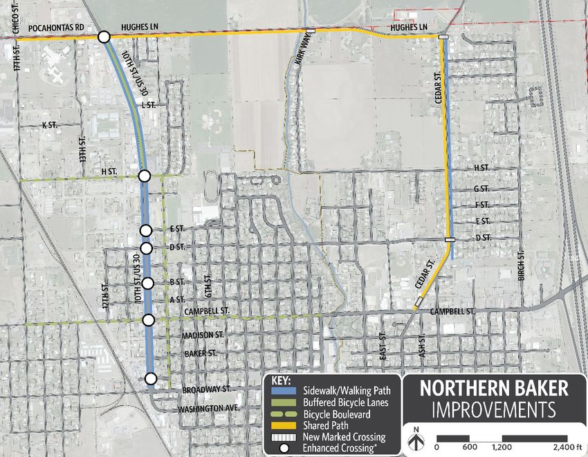
Tech Memo #6: Transportation Solutions Analysis
Northern Baker Transportation Improvement Plan
Figures
Figure 1-1. Project Study Area ...................................................................................................................... 2
Figure 2-1. Preferred Concept Overview ...................................................................................................... 4
Figure 2-2. Detailed Concept Design Improvements .................................................................................... 5
Figure 2-3. Proposed Typical Condition North of H Street ........................................................................... 6
Figure 2-4. Proposed Typical Condition South of H Street ........................................................................... 6
Figure 2-5. Preferred Concept - Pocahontas Road ...................................................................................... 7
Figure 2-6. Preferred Concept - Hughes Lane.............................................................................................. 7
Figure 2-7. Preferred Concept - 10th Street North of D Street ..................................................................... 8
Figure 2-8. Preferred Concept - 10th Street South of D Street..................................................................... 8
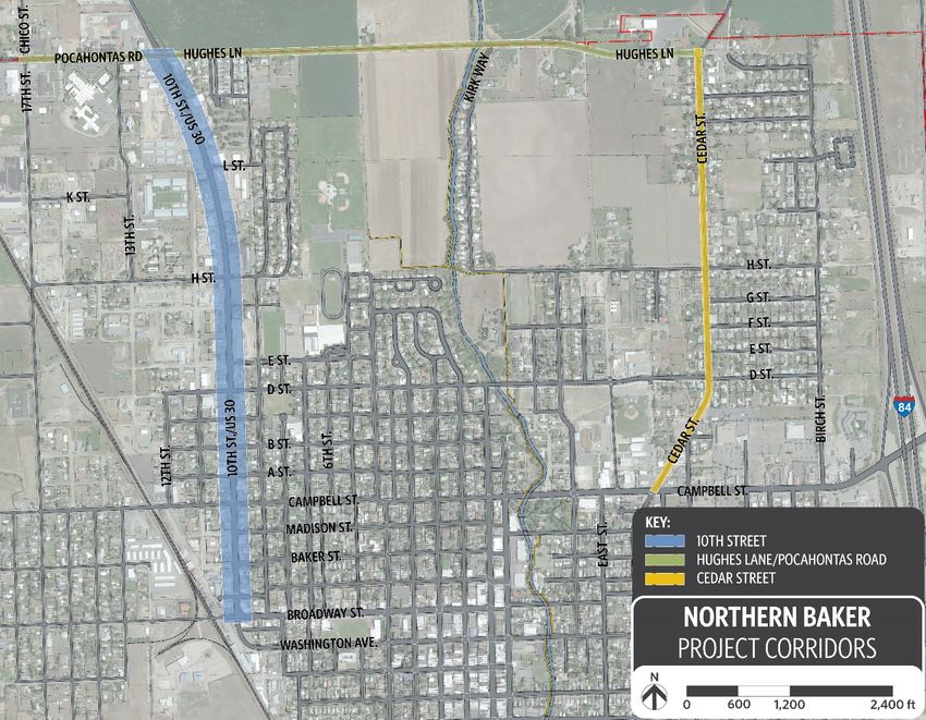
Figure 2-9. Preferred Concept - Intersection of 10th Street and Hughes Lane/Pocahontas Road .............. 9
Figure 2-10. Preferred Concept - Intersection of 10th Street and H Street ................................................ 10
Figure 2-11. Preferred Concept - Intersection of 10th Street and B Street ................................................ 11
Figure 2-12. Preferred Concept - Intersection of Cedar Street and D Street ............................................. 11
Appendices
Appendix A. Future Traffic Operations
Appendix B. BLTS and PLTS Rating Information
Appendix C. Crash Modification Factors
Appendix D. Detailed Cost Planning Levels Estimates
ii | September 29, 2021
Tech Memo #6: Transportation Solutions Analysis
                                                Northern Baker Transportation Improvement Plan

                         Acronyms and Abbreviations

ADA           Americans with Disabilities Act
APM           Analysis Procedures Manual
ARTS          All Road Transportation Safety
BLTS          Bicycle Level of Traffic Stress
CMF           Crash Modification Factor
HCM           Highway Capacity Manual
HCS           Highway Capacity Software
HDM           Highway Design Manual
IAMP          Interchange Area Management Plan
LOS           Level-of-Service
LTS           Level of Traffic Stress
NBTIP         Northern Baker Transportation Improvement Plan
MUTCD         Manual on Uniform Traffic Control Devices
NEO Transit   Northeast Oregon Public Transit
ODOT          Oregon Department of Transportation
OHP           Oregon Highway Plan
ORS           Oregon Revised Statue
OTC           Oregon Transportation Commission
PLTS          Pedestrian Level of Traffic Stress
ROW           right-of-way
TSP           Transportation System Plan
US30          U.S. Highway 30
v/c           volume-to-capacity

                                                                                   September 29, 2021 | iii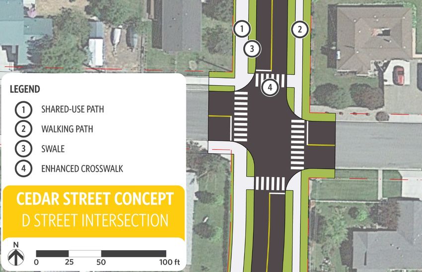
Tech Memo #6: Transportation Solutions Analysis
                                             Northern Baker Transportation Improvement Plan

1   Introduction
    The Northern Baker Transportation Improvement Plan (NBTIP) is being undertaken by
    Baker City in partnership with the Oregon Department of Transportation (ODOT) to
    develop a vision to revitalize a section of U.S. Highway 30 (10th Street or US30) within
    the city limits. The project also focuses on Cedar Street and Hughes Lane/Pocahontas
    Road. The project considered several new street design cross sections for all three
    corridors. A set of preferred design concepts are discussed in detail in Technical Memo
    5. The preferred design concepts are meant to better accommodate multimodal travel
    demand and provide equitable access to destinations along these corridors for people of
    all ages and abilities. The study corridors are shown in Figure 1-1.
    This technical memo provides an overview of the preferred design concepts for the three
    corridors and how the designs will impact operations and connectivity in Baker City and
    includes:
       •   Projected traffic operations and performance along the corridors and at key
           intersections including impacts on freight movement
       •   Improvements to active transportation and transit including an analysis of access
           and comfort level for pedestrians and bicyclists
       •   Initial cost estimates and design impacts on ROW and utilities
       •   Anticipated impacts to safety at key locations

                                                                                 September 29, 2021 | 1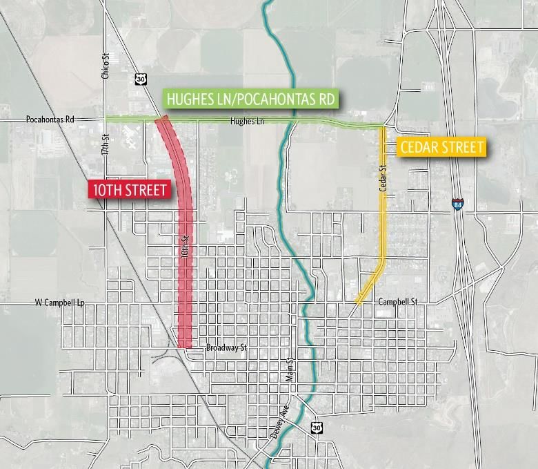
Tech Memo #6: Transportation Solutions Analysis
Northern Baker Transportation Improvement Plan

Figure 1-1. Project Study Area

2             Summary of Improvements and Findings
              A brief summary of findings is provided:
                   •     10th Street – The preferred design concepts for 10th Street includes new bicycle
                         and pedestrian facilities north of H Street while the pedestrian environment is
                         improved by a combination of sidewalk infill and increased sidewalk widths south
                         of H Street. Crossing improvements at H, E, D, B, Campbell and Church Streets
                         will improve crossing conditions for both bicyclists and pedestrians including
                         increasing comfort and reducing potential crashes. The crossing improvements
                         may include marked crosswalks, signage and in some cases curb extensions,
                         median pedestrian refuge, pedestrian signal upgrades and pedestrian activated
                         beacons. The crossing improvements will also increase access to employment
                         areas west of 10th Street for active transportation users. The improvements are
                         designed with freight movement in mind and ensure that freight access and
                         turning movements are not impacted. Figure 2-11 offers an example of the
                         crossing improvements. Pocahontas Road/Hughes Lane – The addition of a
                         separated shared-use path on the southside of the street from 17th Street to
                         Cedar Street will provide people walking and bicycling a separated facility for

2 | September 29, 2021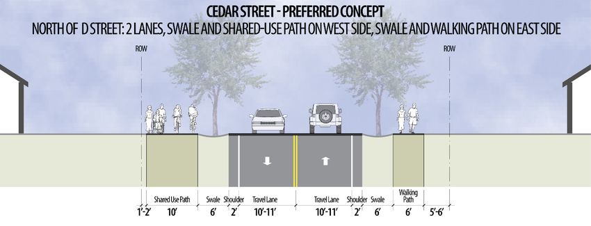
Tech Memo #6: Transportation Solutions Analysis
                                               Northern Baker Transportation Improvement Plan

             recreational trips while connecting to important employment areas and
             community services. The path will be separated by a landscaped swale that may
             include street trees or other plantings. The separated path will reduce crash risks
             for people walking and bicycling while also increasing comfort. Intersection
             crossing improvements at 10th Street/H Street will also improve comfort and
             reduce crash risk while providing improved access to the Saint Alphonsus
             Medical Center.
         •   Cedar Street – Cedar Street will receive a new shared-use path between Hughes
             Lane and D Street on the west side of the street and a new walking path on the
             east side of the street. Both of these facilities will be horizontally separated from
             the roadway and vehicle traffic to provide people walking and biking a
             comfortable experience when using the new facilities. The paths will be
             separated by landscaped swales that may include street trees or other plantings.
             Intersection crossing improvements at H and D Streets will improve access and
             reduce the potential for crashes for people walking and biking. The shared-use
             path South of D Street will continue to Campbell Street while the walking path will
             connect to the Community Center and Northeast Oregon Public (Neo) Transit’s
             local and regional service.

2.1   Summary of Preferred Design Concepts
      The preferred design concepts propose improvements intended to ensure equitable
      access to transportation options for all ages and abilities. These improvements include
      facilities for people walking and bicycling along the project corridors, and suggested
      connections to and enhancements of the larger network of streets and pathways to allow
      for safe and comfortable travel by all modes.
      Figure 2-1 provides an overview of the preferred design concept proposed for each
      corridor while Figure 2-2 provide details on the specific location of improvements.

                                                                                   September 29, 2021 | 3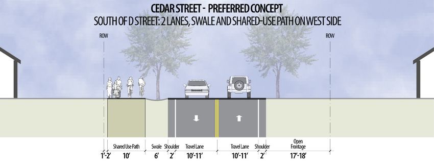
Tech Memo #6: Transportation Solutions Analysis
Northern Baker Transportation Improvement Plan

Figure 2-1. Preferred Concept Overview

4 | September 29, 2021
Tech Memo #6: Transportation Solutions Analysis
                                                           Northern Baker Transportation Improvement Plan

Figure 2-2. Detailed Concept Design Improvements

*Enhanced crossings may include marked crosswalks, median pedestrian refuges, curb extensions and Rectangular
Rapid Flashing Beacons (RRFB) if unsignalized. At Campbell Street, the enhanced crossings will include pedestrian
countdown timers featuring a leading pedestrian interval, marked crosswalks and curb extensions.

2.2          Preferred Design Concept Cross-Sections
             Below are the preferred cross section designs outlined in more detail in Technical Memo
             5.

                                                                                               September 29, 2021 | 5
Tech Memo #6: Transportation Solutions Analysis Northern Baker Transportation Improvement Plan 2.2.1 10th Street Cross-Sections Figure 2-3. Proposed Typical Condition North of H Street Figure 2-4. Proposed Typical Condition South of H Street 6 | September 29, 2021
Tech Memo #6: Transportation Solutions Analysis
                                         Northern Baker Transportation Improvement Plan

2.2.2    Pocahontas Road and Hughes Lane Cross-Sections
Figure 2-5. Preferred Concept - Pocahontas Road

Figure 2-6. Preferred Concept - Hughes Lane

                                                                             September 29, 2021 | 7
Tech Memo #6: Transportation Solutions Analysis
Northern Baker Transportation Improvement Plan
2.2.3 Cedar Street Cross-Sections
Figure 2-7. Preferred Concept - 10th Street North of D Street
Figure 2-8. Preferred Concept - 10th Street South of D Street
2.3 Preferred Intersection Design Concepts
Below are the preferred design concepts for a selection of intersection outlined in more
detail in Technical Memo 5.
8 | September 29, 2021Tech Memo #6: Transportation Solutions Analysis
Northern Baker Transportation Improvement Plan
Figure 2-9. Preferred Concept - Intersection of 10th Street and Hughes
Lane/Pocahontas Road
*The exact alignment will be refined during the design phase and after additional outreach.
September 29, 2021 | 9Tech Memo #6: Transportation Solutions Analysis Northern Baker Transportation Improvement Plan Figure 2-10. Preferred Concept - Intersection of 10th Street and H Street 10 | September 29, 2021
Tech Memo #6: Transportation Solutions Analysis
                                           Northern Baker Transportation Improvement Plan

Figure 2-11. Preferred Concept - Intersection of 10th Street and B Street

Figure 2-12. Preferred Concept - Intersection of Cedar Street and D Street

                                                                             September 29, 2021 | 11
Tech Memo #6: Transportation Solutions Analysis
Northern Baker Transportation Improvement Plan
3 Transportation Solutions Assessment
This section provides an overview of the future transportation conditions on 10th Street,
Cedar Street, and Hughes Lane/Pocahontas Road based on the concept design
presented in Technical Memo 5. This section includes:
• Motor Vehicle Operations Assessment
• Freight/Heavy Vehicle Assessment
• Active Transportation Assessment
• Transit Assessment
• Transportation Safety Improvements and Analysis
• ROW and Utility Impacts
• Concept Design Comparison to Previously Identified Projects
• Planning Level Cost Estimates
• Improvement Phasing
3.1 Motor Vehicle Operations Assessment
This section provides a summary of motor vehicle operations at the four study
intersections along 10th Street:
• 10th Street/Hughes Lane - unsignalized
• 10th Street/E Street - unsignalized
• 10th Street/Broadway Street - unsignalized
• 10th Street/Campbell Street - signalized
A traffic analysis was performed for future year (2040) conditions following the
recommendations and procedures included in Chapters 5, 12, and 13 of the ODOT
Analysis Procedures Manual (APM). Detailed analysis output is provided in Appendix A.
Traffic volume forecasts were developed using an assumed annual growth rate of 1.0
percent per year. The population of Baker City has changed very little in the past 20
years and the current ODOT Future Highway Volume Table shows annual growth rates
on 10th Street ranging from 0.1 to 0.6 percent. While not directly comparable to traffic
growth, the 2013 Baker City Comprehensive Plan assumed a projected population
growth for the City of 0.8 percent per year. An annual growth rate of 1 percent per year
represents a conservative estimate for the future conditions analysis.
Traffic analysis was performed to determine volume-to-capacity (v/c) ratios for
comparison to ODOT mobility thresholds consistent with Action 1F.1 of the Oregon
Highway Plan (OHP) and the 20-year design mobility standards in the ODOT Highway
Design Manual (HDM). ODOT mobility standards provide acceptable v/c ratios for project
12 | September 29, 2021Tech Memo #6: Transportation Solutions Analysis
Northern Baker Transportation Improvement Plan
development and design. Based on the concept design presented in Technical Memo 5,
the 10th Street/Hughes Lane intersection includes recommended improvements to the
existing lane configuration (see Figure 2-9) and is the only intersection that was
compared to both OHP (No-Build) and HDM (Build) mobility standards.
The 10th Street corridor is located within the limits of Baker City and designated as a
District Highway by the OHP. The OHP mobility targets for No-Build conditions are an
overall intersection v/c ratio of 0.95 for the signalized intersection at 10th
Street/Campbell Street, and a 0.95 v/c ratio for the unsignalized state highway and local
street approaches at the Broadway Street, E Street, and Hughes Lane intersections. The
HDM mobility target for the proposed intersection design concept at 10th Street/Hughes
Lane is a 0.80 v/c ratio for the unsignalized state highway and local street approaches.
Highway Capacity Manual (HCM) compliant Level-of-Service (LOS) results have also
been provided.
Table 3-1 summarizes the existing year peak hour operational results. Based on the
future year (2040) conditions analysis, all study area intersections meet OHP and HDM
mobility targets. The signalized intersection at Campbell Street is operating at LOS A and
the unsignalized intersections at E Street and Broadway Street are operating at LOS C.
The Hughes Lane intersection is operating at LOS E in both the No-Build and Build
scenarios and the results are based on the stop-controlled westbound left-turn
movement. While the overall LOS does not change with the recommended
improvements, the v/c ratio is significantly improved from 0.74 to 0.38 and the delay is
reduced by over 20 percent.
Table 3-1. Future Year (2040) Peak Hour Operations
Minor Street
Major Street
Unsignalized Intersection1 LOS
v/c
v/c Delay (s)
10th Street & Hughes Lane (No-Build) 0.12 0.74 44.5 E
10th Street & Hughes Lane (Build) 0.12 0.38 35.3 E
10th Street & E Street 0.26 0.13 19.0 C
10th Street & Broadway Street 0.17 0.20 12.7 C
Signalized Intersection2 v/c Delay (s) LOS
10th Street & Campbell Street 0.32 7.0 A
1
Unsignalized intersection LOS based on worst stop-controlled movement.
2
Signalized intersection LOS based on overall intersection operations.
In addition to the operational analysis, a signal warrant analysis was performed at the
10th Street/Hughes Lane intersection using both the existing (2020) and future year
(2040) traffic volumes. The signal warrant analysis focused on the peak hour, 4-hour,
and 8-hour volume warrants and was performed using Highway Capacity Software
(HCS), which replicates the procedures provided in the Manual on Uniform Traffic
Control Devices (MUTCD). Only the peak hour signal warrant (Warrant 3) was met in the
future year (2040), and only if the population was assumed to remain less than 10,000.
Based on the signal warrant analysis, a traffic signal is not warranted at this location at
this time.
September 29, 2021 | 13Tech Memo #6: Transportation Solutions Analysis
Northern Baker Transportation Improvement Plan
3.2 Freight/Heavy Vehicles Assessment
This section summarizes future movement of freight. Considerations related to freight
and heavy vehicles in the study area.
3.2.1 Freight Improvements and Considerations
10th Street (U.S. Highway 30 [US30]) is designated a District Highway. According to
ODOT’s TransGIS tool, US30 does not show up as an OHP Freight Route, Reduction
Review Route, or High Clearance Route. The design phase for 10th street considered
and evaluated many possible designs and cross sections. The resulting preferred design
concepts do not include freight specific improvements but the designs do accommodate
freight turning movements.
The proposed improvements for 10th Street are different for the sections north and south
of H Street. South of H Street, space is allocated to accommodate street parking where
existing businesses are more concentrated. North of H Street, a bicycle lane is integrated
into the roadway where demand for on-street parking is less pronounced. For the section
north of H Street, the number of lanes remains the same though lane widths are reduced
due to the addition of a seven-foot buffered bike lane on either side of the road. The two
outside lanes, which provided space for parking and travel, will be reduced from 18 feet
to 12 feet. Twelve feet is the Oregon HDM recommended minimum width for a travel
lane on any identified freight route, thus the preferred design concept for 10th should
accommodate freight movement. For the section south of H Street, the two outside lanes
remain 12 feet wide while the inner two lanes are reduced from 12 to 11 feet. The
proposed lane widths for Hughes Lane and Cedar Street, which are not used as heavily
for freight movement, will be between 10 and 11 feet.
The project team evaluated the curb extensions, pedestrian refuge islands, and
enhanced pedestrian crosswalks and determined that truck turning movements will not
be impacted by these improvements. The curb extensions will, at their maximum, be as
wide as the parking lane and will be designed with a turning radius that accommodates
heavy vehicle turning movements.
3.2.2 Hole-in-the-air Considerations
A highway’s “vehicle-carrying capacity” refers to the horizontal and vertical clearance
through which a vehicle can move. This clearance is informally known as the “hole-in-
the-air”. The size or capacity of this clear space determines the maximum size load a
truck can move along the road. This capacity can be constrained through the addition of
infrastructure such as bridges, light signals, or curb extensions, thus the Oregon
Transportation Commission (OTC) identified certain roads that were important to freight
movement as Reduction Review Routes. Oregon Revised Statute (ORS) 366.215 states
that the OTC shall not permanently reduce the “vehicle-carrying capacity” of a Reduction
Review Route unless safety or access considerations require the reduction, or a local
government requests an exemption and Commission determines it is in the best interest
of the state and freight movement is not unreasonably impeded.
It is important to note that none of the roads in this project are identified as Reduction
Review Routes. There are some minor reductions to the “hole-in-the-air” through the
14 | September 29, 2021Tech Memo #6: Transportation Solutions Analysis
Northern Baker Transportation Improvement Plan
addition of curb extensions that protrude to the extent of the parking lane at certain
intersections. Otherwise, the overall right-of-way (ROW) from curb to curb will not be
reduced and, in fact, will increase in some areas.
Figure 2-2 shows the intersections where curb extensions will be installed. The planned
curb extensions will not exceed more than nine feet wide along 10th Street, equivalent to
the width of the parking lane. If curb extensions are installed on both sides of the
roadway, the total width would equal up to 18 ft. This would produce a minimum
horizontal clearance of 46 feet. The final width of the curb extensions will be determined
during the design phase and after additional outreach is considered.
3.3 Active Transportation Assessment
This section summarizes bicycle and pedestrian improvements and future conditions
found in Baker City along 10th Street, Cedar Street, and Hughes Lane/Pocahontas
Road. For the three project roadways, Bicycle and Pedestrian Level of Traffic Stress
(LTS) were calculated and findings presented.
3.3.1 Active Transportation Improvements
This section summarizes the active transportation improvements outlined in Technical
Memo 5 and shown in Figure 2-2. The preferred design concepts propose a combination
of sidewalk, walking paths and shared-use paths along the three corridors and various
intersection crossing enhancements at key locations. The improvements will increase
access to transit and key destinations while reducing potential bicycle and pedestrian
involved crashes.
10th Street Improvements
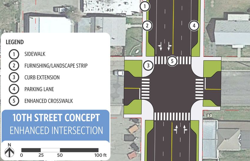
The 10th Street corridor will feature two typical cross-sections with H street acting as the
dividing line between the two as shown in Figure 2-3 and Figure 2-4. South of H Street,
the cross-section for 10th will remain unchanged except for completing five-foot wide
sidewalks on both sides of the corridor. Active transportation improvements north of H
Street will include a buffered bike lane in both directions measuring five feet in width with
a two-foot buffer to the adjacent travel lane. Sidewalks will be installed on both sides of
the corridor measuring five feet in width and featuring a curb side, five-foot hardscape
buffer with pedestrian scale lighting.
A parallel bicycle boulevard will run one block to the east along 9th Street between
H Street and Broadway. This will create an alternate route for people walking and biking
and provides a calmer and more comfortable route that is likely to reduce interactions
between vehicles and people using 9th Street compared to 10th Street. The parallel
route will provide similar access benefits to people walking and biking as a bicycle lane
on 10th Street without the need to reallocate roadway space on 10th Street.
A series of intersection improvements will improve bicycle and pedestrian safety,
connectivity, and ease of crossing. Table 3-2 below summarizes the improvements at
each intersection. Figure 2-9, Figure 2-10 and Figure 2-11 show detailed plan concepts
for intersection improvements along 10th Avenue at the intersections of Hughes
Lane/Pocahontas Road, H Street, and B Street.
September 29, 2021 | 15Tech Memo #6: Transportation Solutions Analysis
Northern Baker Transportation Improvement Plan
Table 3-2. Intersection Improvements
Marked Curb
Intersection Other
Crosswalk Extensions
10th Street (US 30)
Crossing Signage, RRFB* or
HAWK** beacon, additional
horizontal separation of
Hughes Lane / Pocahontas Road
vehicles and active modes,
geometric dimension changes
Yes as shown in Figure XX
Crossing Signage, Median
H Street Refuge and bicycle way-finding
Yes Yes signage
E Street Yes Yes Crossing Signage
D Street Yes Yes Crossing Signage
B Street Yes Yes Crossing Signage
Pedestrian Countdown Timer
Campbell Street with a leading pedestrian
Yes Yes interval
Church Street Yes Yes Crossing Signage
*Rectangular Rapid-Flashing Beacon
**High-Intensity Activated Crosswalk
10th / Hughes Lane Intersection Improvements
Figure 2-9 shows the proposed intersection modifications at Pocahontas Road/Hughes
Lane. The proposed buffered bike lanes along the southern 10th Street approach would
tie directly into the shared-use path, allowing for seamless travel by bike. To connect the
SUP east and west of the intersection and make the crossing of 10th more comfortable, a
marked crosswalk, warning signage and either a rectangular rapid flashing beacon
(RRFB) or high-intensity activated crosswalk (HAWK) signal should be installed. The
intersection design also realigns the intersection approaches to create better sight lines
for drivers and to create a curve as southbound traffic approaches the intersection that
will slow drivers.
Hughes Lane/Pocahontas Road Improvements
The Hughes Lane and Pocahontas corridor will feature two typical cross-sections with
10th Street acting as the dividing line between the two as shown in Figure 2-5 and Figure
2-6. Hughes Lane will feature a separated shared-use path between 10th Street and
Cedar Street on the south side of the street. The path will be 10 feet wide and separated
from vehicle traffic by a 6-foot swale and a 2-foot paved shoulder. The shared-use path
will continue across 10th Street and along Pocahontas Road with the same 10-foot
width. The shared-use path west of 10th Street will be separated from traffic with a f4-foot
paved buffer featuring paint and vertical delineators. The intersection improvements are
summarized below in Table 3-3.
16 | September 29, 2021Tech Memo #6: Transportation Solutions Analysis
Northern Baker Transportation Improvement Plan
Table 3-3. Intersection Improvements
Marked Curb
Intersection Other
Crosswalk Extensions
Hughes Lane / Pocahontas
Kirkway Street* Yes Crossing Signage
*The crossing at Kirkway Street is oriented east/west to allow the SUP to cross Kirkway Street.
Cedar Lane Improvements
The Cedar Street corridor will feature two typical cross-sections with D Street acting as
the dividing line between the two as shown in Figure 2-7 and Figure 2-8. Cedar Street
north of D Street will feature a shared-use path on the west side of the street. The
shared-use path will be 10 feet wide and be separated from traffic by a 6-foot,
landscaped swale and a 2-foot paved shoulder. On the eastside of the street will be a 6-
foot walking path, again separated from traffic by a 6-foot, landscaped swale and a 2-foot
paved shoulder. The shared-use path west of 10th Street will continue on the west side
of the street but the sidewalk on the east side will not.
A series of intersection improvements will be installed to improve bicycle and pedestrian
safety, connectivity and ease of crossing. Table 3-4 below. Figure 2-12. Preferred
Concept - Intersection of Cedar Street and D Street shows detailed a plan concept for
intersection improvements at Cedar Street and D Street.
Table 3-4. Intersection Improvements
Marked Curb
Intersection Other
Crosswalk Extensions
Cedar Street
Hughes Lane* Yes Crossing Signage
D Street Yes Crossing Signage
Clark Street** Yes
*The crossing at Hughes Lane is oriented east/west to allow the SUP to connect to the eastside
walking path on Cedar Street.
**The crossing is oriented north/south to allow the SUP to cross Clark Street.
3.3.2 Bicycle and Pedestrian Level of Traffic Stress
LTS is a key indicator in measuring how comfortable a roadway segment or intersection
is for person walking or biking to navigate. LTS objectively measures several roadway
factors including traffic volumes, speeds, and the presence and quality of bicycle and
pedestrian facilities to produce an LTS rating. Ratings are measured 1 through 4 with 1
representing the most comfortable environment for active transportation users.
Table 3- reports the Bicycle Level of Traffic Stress (BLTS) and Pedestrian Level of Traffic
Stress (PLTS) ratings for roadway segments and intersections. The LTS ratings for
segments are scored based on the worst performing roadway characteristic. The table
shows the LTS rating for the future roadway conditions and shows the change in LTS
rating compared to the existing conditions. The majority of LTS ratings improved and
none of the future conditions are expected to be worse than today. For example, a
September 29, 2021 | 17Tech Memo #6: Transportation Solutions Analysis
Northern Baker Transportation Improvement Plan
roadway may score LTS 2 based on volumes but LTS 4 based on bicycle facility type
and thus the segment will receive an overall score of LTS 4.
The concept design roadway segments generally rank LTS 1 and 2 for both bicycles and
pedestrians primarily due to the increased separation of active modes from vehicle
traffic. Intersection crossing and approach LTS scores also improved thanks to the
combination of marked crossings, signage, curb extensions and physical separation from
travel lanes. 10th Street south of E Street remains a BLTS 3 for both the segments and
intersections as no bicycle facilities are being proposed in those locations.
Table 3-5. Future Build BLTS and PLTS Ratings
BLTS
Location PLTS Rating
Rating
10th Street (US 30)
Hughes Lane to H Street 2 (+1)* 2 (+2)
H Street to Campbell Street 3 2 (+1)
Campbell Street to Broadway 3 2 (+1)
Hughes Lane / Pocahontas Road
17th Street to 10th Street 1 (+2) 2 (+2)
10th Street to Kirkway Street 1 (+2) 2 (+2)
Kirkway Street to Cedar Street 1 (+2) 2 (+2)
Cedar Street
Hughes Lane to H Street 1 (+2) 2 (+2)
H Street to D Street 1 (+2) 2 (+2)
D Street to Campbell Street 1 (+2) 2 (+2)
Intersections (Approach and Crossing LTS Scores)
10th Street/Hughes Lane 3 (+1) 2 (+2)
10th Street/E Street 3 3 (+1)
10th Street/Campbell Street 3 2 (+1)
10th Street/Broadway Street 3 2
Pocahontas Road/17th Street 3 (+1) 2 (+1)
Hughes Lane/Kirkway Street 2 (+1) 2 (+1)
Hughes Lane/Cedar Street 2 (+1) 2 (+1)
Cedar Street/H Street 1 2
Cedar Street/D Street 1 1
Cedar Street/Campbell Street 1 1
*(+1) indicated an improvement in the LTS rating
The ODOT APM provides guidance on target LTS ratings that roadways undergoing
improvements should aim for in maximizing active transportation mode share. For
bicyclists, BLTS 2 is often the target that generally appeals to most potential riders. Near
schools, a BLTS 1 is desirable for elementary schools while BLTS 2 is allowable for
middle and high schools. For pedestrians, a PLTS 2 is generally the minimum target for
pedestrian routes. Roadways within a quarter mile of schools should use a target PLTS 1
18 | September 29, 2021Tech Memo #6: Transportation Solutions Analysis
Northern Baker Transportation Improvement Plan
for elementary schools and PLTS 2 for middle and high schools. Roadways near medical
facilities should also have a target of PLTS 1.
The following locations will not meet the above guidance targets including:
• Pocahontas Road between 17th Street and 10th Street scores a PLTS 2,
according to the ODOT APM, the target should be a PLTS 1 because of the Saint
Alphonsus Medical Center. Additional horizontal separation between pedestrians
and motor vehicle traffic or a reduced speed limit would result in a PLTS 1.
• 10th Street between E Street and Campbell Street scores a PLTS of 2 and a
BLTS of 3. Because this section of 10th Street is within a quarter mile of the
Baker Early Learning Center, both the PLTS and BLTS should score a 1
according to the ODOT APM. Additional horizontal separation between
pedestrians and motor vehicle traffic or a reduced speed limit would result in a
PLTS 1. The addition of bicycle lanes would improve the BLTS score along this
segment.
3.4 Transit Assessment
Specific transit improvements such bus stop facilities are not included in the preferred
design concepts. However, the active transportation improvements outlined in Technical
Memo 5 and shown in Figure 2-2 will improve access to local and regional transit
service. The access to transit due to the active transportation improvements are
described below.
10th Street Improvements
Bus stops currently exist on both sides of 10th Street at the intersection with E Street.
Improvements to 10th Street will include completing the sidewalk network along the
corridor and providing intersection crossing improvements at the E Street and H Street
intersections. These improvements will increase access to transit, make crossing the
street more comfortable and reduce the crash risks that pedestrians face when crossing
10th Street to access transit.
Pocahontas Road Improvements
A bus stop currently exists on the south side of Pocahontas Road in front of Saint
Alphonsus Medical Center. The installation of a shared-use path along the southside of
Pocahontas Road will improve access to the transit stop. Additionally, the intersection
improvements proposed to the intersection of 10th Street and Hughes Lane/Pocahontas
Road will also improve access, making crossing 10th Street easier and reduce crash
risks to pedestrians.
Cedar Lane Improvements
A bus stop currently exists just south of D Street at the headquarters for NEO Transit.
This location also serves as a stop for NEO Transit’s regional shuttle service that
connects Baker City to other communities in Eastern Oregon. The shared-use path along
Cedar Street and intersection improvement proposed for the crossing at D Street will
September 29, 2021 | 19Tech Memo #6: Transportation Solutions Analysis
Northern Baker Transportation Improvement Plan
increase access to both the local and regional transit service as well as reduce crash risk
for pedestrians.
3.4.1 Future Transit Assessment
The preferred design concepts do not affect the operations of Neo Transit’s local and
regional transit services. However, the active transportation improvements described
above will increase access to transit services, improve pedestrian comfort, and reduce
pedestrian crash risk at three key locations as detailed above.
3.5 Transportation Safety Improvements and Analysis
This section provides a summary of the safety impacts that can be expected based on
the countermeasures being proposed within the preferred concept designs. Table 3-6
provides a summary of the Crash Modification Factors (CMF) for each countermeasure
that is being proposed within the preferred concept designs with complete details on
each CMF available in Appendix C. The most applicable CMF for each treatment was
selected. In the case of multiple treatments at a single location, the most conservative
estimate of benefits is provided. For reference, a CMF of 0.80 should be expected to
reduce crashes by a factor of 0.80. Stated another way, a CMF of 0.80 would reduce
crashes by 20 percent. Each CMF is applicable to a particular crash type and/or crash
severity.
Table 3-6. Safety Crash Modification Factors
Countermeasure Crash Injury
Facility Type CMF Source
ID No. Type Type
Crosswalk with Sign at
Unsignalized 0.85 ODOT ARTS* BP15 Pedestrian All
Intersection
Curb Ramps and
Extensions with Marked 0.63 ODOT ARTS BP16 Pedestrian All
Crosswalk and
Pedestrian Signs
Curb Extension 0.70 ODOT ARTS I33 All All
Pedestrian Median
0.69 ODOT ARTS BP8 Pedestrian
Refuge All
Sidewalk 0.80 ODOT ARTS BP29 Pedestrian All
Buffered Bike Lane 0.53 ODOT ARTS BP24 Bicycle All Injury
FHWA CMF
Shared-use Path
0.75 Clearinghouse 9250 Bicycle All
Pedestrian Countdown
0.69 ODOT ARTS BP1 Pedestrian
Timer All
Leading Pedestrian
0.63 ODOT ARTS BP3 Pedestrian
Interval All
RRFB at Intersection 0.90 ODOT ARTS BP10 Pedestrian All
*ODOT All Roads Transportation Safety (ARTS)
20 | September 29, 2021Tech Memo #6: Transportation Solutions Analysis
Northern Baker Transportation Improvement Plan
3.5.1 10th Street Improvements
• Completing the sidewalks north of H Street on both sides of the roadway should
provide a potential pedestrian crash reduction of 0.80. The buffered bike lanes
will similarly provide a potential bicycle crash reduction of 0.53.
• The intersection improvements at H Street include a pedestrian median refuge,
marked crosswalks, curb ramps, pedestrian signage and curb extensions. These
countermeasures should provide a potential pedestrian crash reduction of 0.63
while the curb extensions should provide a potential crash reduction of 0.70 for
all crash types.
• The intersection with Campbell will receive curb extensions and the signals
upgraded to include a pedestrian countdown timer and a leading pedestrian
interval. The curb extension should provide a potential crash reduction of 0.70 for
all crash types while the combined pedestrian countdown timer and leading
interval should provide a potential pedestrian crash reduction of 0.69.
• Intersection crossing improvements at E, D, B and Church Street will include a
marked crosswalk with signage, curb extensions, and Americans with Disability
Act (ADA) curb ramp that should provide a potential pedestrian crash reduction
of 0.63. The curb extensions should also provide a potential crash reduction of
0.70 for all crash types.
• While there is no specific CMF for the realignment proposed at the intersection of
10th/Hughes Lane/Pocahontas Road, from a qualitative perspective there are
anticipated safety benefits. The revised alignment reduces the skew angle and
provides separate turn lanes at the westbound and eastbound approach
clarifying travel through the intersection. The curve at the southbound approach
to the intersection may slow motorists as they are traveling into Baker City. The
enhance crosswalks will provide connections to the sidewalk on 10th Street and
shared use path on Hughes and Pocahontas.
3.5.2 Pocahontas Road/Hughes Lane Improvements
• Installing the shared use path along Pocahontas Road/Hughes Lane should
provide a potential crash reduction of 0.75 for bicyclists for the length of the
corridor.
3.5.3 Cedar Lane Improvements
• The walking path and shared use path north of D Street should provide a
potential crash reduction of 0.75 for bicyclists.
• The shared use path south of D Street should provide a potential crash reduction
of 0.80 for pedestrians and bicyclists.
• The intersection improvements at D Street include curb extensions, marked
crossing, and crossing warning signage. The improvements should provide
potential crash reduction for pedestrians of 0.63 at the intersection. The curb
extensions should also provide potential crash reduction benefits for all crash
types by a factor of 0.70.
September 29, 2021 | 21Tech Memo #6: Transportation Solutions Analysis
Northern Baker Transportation Improvement Plan
3.6 Utilities and ROW Impacts
This section briefly summarizes ROW and underground utility line impacts based on the
preferred concept designs outlined Technical Memo 5.
3.6.1 10th Street
• Utility poles on both the west and east side of the corridor currently infringe on
the sidewalk. The preferred alternative includes 8-foot sidewalks on both sides of
the corridor and the utility poles will pose a challenge to accommodate the full
design width along the entire corridor.
• Additional ROW will need to be acquired in the NE and SE corners of the Hughes
Street/Pocahontas Road intersection to accommodate the preferred intersection
realignment. Additionally, several utility poles and underground utilities may need
to be relocated to align the preferred intersection design.
• A minor amount of additional ROW will need to be acquired in the NE and NW
corners of the H Street intersection in order to accommodate the proposed curb
extensions and median island refuge. The exact amount of right-of-way will be
revisited during the final design phase of the project after survey is conducted.
3.6.2 Hughes Lane/Pocahontas Road
• Utility poles on the southside of Pocahontas Road will make integrating the
shared-use path within the existing ROW challenging. In order to make the
preferred design feasible, the centerline of the road will need to be shifted
several feet to the north in order to avoid the potential impacts to the utility poles.
• The bridge on Hughes Lane over the Powder River is not wide enough to
accommodate the proposed shared-use path on the southside of the roadway.
A future bike/ped bridge crossing the Powder River near where the Leo Adler
Memorial Parkway Trail meets Hughes Lane may need additional ROW
depending on where the bridge would be located. Further study of the ROW
impacts should be undertaken.
3.6.3 Cedar Street
• The centerline of the roadway may need to be adjusted eastward to the south of
the D Street intersection to accommodate the shared-use path through the curve
in Cedar Street. The roadway should stay within the existing ROW.
• Utility poles on the eastside of the roadway will make accommodating the
proposed six-foot walking path north of D Street challenging. A more complete
inventory and mapping of the ROW and utility poles should be undertaken during
the design phase for the improvements.
22 | September 29, 2021Tech Memo #6: Transportation Solutions Analysis
Northern Baker Transportation Improvement Plan
3.7 Concept Design Comparison to Previously Identified
Projects
This section summarizes previously identified projects and compared them to the
preferred concept designs. The information in this section was taken from the 2013
Baker City Transportation System Plan (TSP), the 2005 Baker County TSP, and the
2016 Interchange Area Management Plan (IAMP). The information is summarized in
Table 3-7.
Previous TSP documents identified traffic signal improvements at the intersections of
Hughes Lane/Cedar Street, 10th Street/D Street, and Hughes Lane/10th Street.
However, based on the assessment of traffic operations in this technical memo, traffic
signals are not warranted at these locations based on both existing and future traffic
projections. While traffic signals had previously been proposed at these locations, the
traffic volumes do not meet the necessary warrants to upgrade these intersections.
Table 3-7. Preferred Concept Design Compared to TSP Projects
TSP Project TSP
Location Preferred Concept Design Source
Description Update
10th Street
Hughes Intersection • Improvements include Baker County Yes
Lane/10th Signalization intersection realignment, the TSP, Project
Street addition of turn lanes, and 8
improved bicycle and pedestrian
crossing facilities.
• Preferred intersection design will
improve operations, sightlines,
and reduce crash risks.
• Traffic signal warrants are not
met.
Intersection Intersection • Intersection crossing Baker City Yes
of L, H, E, Pedestrian improvements are proposed for TSP -
and Broadway Crossing H, E, D, B, Campbell and Identified in
Streets Improvements Church. Figure 2-1
• The intersections of L and
Broadway are not slated for
crossing improvements.
10th Street/D Intersection • Preferred intersection design will Baker City Yes
Street Signalization improve pedestrian crossing with TSP, Project
a marked crosswalk, signage, R19
and curb extensions.
• Traffic signal warrants are not
met.
10th Street from Pedestrian • Improvements will include Baker City Yes
Broadway to network completing the sidewalks along TSP, Project
Hughes Lane improvement - 10th between Broadway and P45
Sidewalk infill Hughes Lane.
• No pedestrian crossing
improvements are slated for the
intersection at Broadway and are
instead identified one block north
at Church Street.
10th Street from Parallel Bicycle • No such project in TSP. N/A Yes
H Street to Boulevard along • Preferred concept would create
Broadway Street 9th Street a low-stress bicycle boulevard
paralleling 10th Street that would
September 29, 2021 | 23Tech Memo #6: Transportation Solutions Analysis
Northern Baker Transportation Improvement Plan
TSP Project TSP
Location Preferred Concept Design Source
Description Update
10th Street
function as an alternative route
for bicyclists.
Pocahontas/Hughes Lane
17th Street from Multi-use path • Shared-use path along Baker City
Indiana Avenue Pocahontas will be able to tie TSP, Project
to Pocahontas into the future path along 17th M4
Road Street.
Hughes 17th Street Multi- • Shared-use path along Baker City
Lane/Pocahontas use path Pocahontas will be able to tie TSP, Project
Road from including tie-in to into the future path along 17th M2
Settlers Loop to Pocahontas Street
Cedar Street multi-use path at
the intersection
with 17th Street
Cedar Street
Hughes Intersection • The Preferred concept design I-84 IAMP,
Lane/Cedar Improvements: does not propose changes to the Project B
Street • Phase 1 - intersection.
Eastbound right
turn lane
• Phase 2 -
Southbound right
turn lane
• Phase 3 - All-
way stop
improvement
• Phase 4 -
Signalization
Hughes Endorsement of • The Preferred concept design Baker City
Lane/Cedar the IAMP does not address signalization or TSP, Project
Street intersection turn-pocket improvements at R23
improvements Hughes Lane and Cedar Street.
above
Cedar Street Sidewalk infill • Pedestrian improvements, Baker City
from Campbell and crossing including a sidewalk and shared- TSP, Project
Street to Hughes improvements at use path are included north of D R23
Lane H and D Streets Street.
• Crossing improvements are
included for the intersection with
D Street.
Cedar Street Bike lane - • A shared-use path is included in Baker City Yes
from Campbell signing and the design for the length of TSP, Project
Street to Hughes striping Cedar Street between Hughes R25
Lane Lane and Campbell Street.
Cedar Street/ Intersection • The shared-use path on the Baker City
B Street Safety west side of Cedar Street will TSP, Project
improvement separate bicycle and pedestrian R23
traffic from vehicle traffic and
reduce crash risk.
• No modifications to the
intersection itself are being
proposed.
Other Roadways
9th Street from H Bicycle • Install signage and lane Baker City Yes
Street to Boulevard / markings to create low stress TSP, Project
Broadway Neighborhood street. P35
Route
24 | September 29, 2021Tech Memo #6: Transportation Solutions Analysis
Northern Baker Transportation Improvement Plan
TSP Project TSP
Location Preferred Concept Design Source
Description Update
10th Street
• TSP project P35 addresses
sidewalk infill
Campbell Street Bicycle • Install signage and lane Baker City Yes
from 17th Street Boulevard / markings to create low stress TSP, Project
to Resort Street Neighborhood street. M35
Route • Campbell is identified in the
TSP as a future bicycle route
west of 10th Street.
H Street from Bicycle • Install signage and lane N/A Yes
17th Street to 8th Boulevard / markings to create low stress
Drive Neighborhood street.
Route
4 Planning Level Cost Estimates
This section provides a planning level cost estimates for the proposed design concepts.
Table 4-1 includes a breakdown of costs including for active transportation and general
roadway improvements. No transit or freight specific improvements were identified. More
information on the costs are included in Appendix D.
Table 4-1. Planning Level Cost Estimates
10th Street Corridor
Total $ 10,675,884
Roadway $ 5,045,000
Active Transportation $ 1,038,550
Contingency, Mobilization, Maintenance of Traffic, Erosion Control $ 4,595,250
Cedar Street Corridor
Total $ 1,716,797
Roadway $ 77,000
Active Transportation $ 856,300
Contingency, Mobilization, Maintenance of Traffic, Erosion Control $ 735,240
Pocahontas Road and Hughes Lane Corridor
Total $ 1,850,869
Roadway $ 129,000
Active Transportation $ 925,700
Contingency, Mobilization, Maintenance of Traffic, Erosion Control $ 796,510
1. Construction estimate represents 2021 dollars
2. ODOT bid history tabs were used to determine unit prices
3. Full depth pavement replacement is assumed. 9"AC/18"AB
4. A 50% contingency was placed on all bid items listed
September 29, 2021 | 25Tech Memo #6: Transportation Solutions Analysis
Northern Baker Transportation Improvement Plan
5. Mobilization, Maintenance of Traffic, and Erosion Control includes the 30% contingency for these percentage-
based items
6. Estimates do not include Right-of-way, engineering, construction management, administrative costs, or utility
relocations
Total costs for the three corridors total $14,200,000. Construction costs make up
$8,100,000, including $2,800,000 for active transportation and $5,300,000 for general
roadway improvements. The remaining costs of $6,000,000 consist of contingency,
mobilization, maintenance of traffic and erosion control.
5 Improvement Phasing
This section proposes phasing options for completing the preferred design concept
improvements across the three corridors. 10th Street improvements should be prioritized
to be completed first due to ODOT funding for the corridor currently being available.
Table 5-1 below details the proposed phasing. Facilities in the table below are prioritized
as either near-term (0-5 years) or mid-term (5-10 years) and are subject to the availability
of funding.
Table 5-1. Preferred Design Concept Phasing
Priority
Improvements Location
Timeline
10th Street
Intersection
10th Street and Pocahontas Road/Hughes Lane Near-term*
Realignment
Buffered Bike Lanes Between H Street and Pocahontas Road/Hughes Lane Near -term
Sidewalks Between H Street and Pocahontas Road/Hughes Lane Near -term
10th Street Crossing Intersections with streets H, E, D, B, Campbell and
Near -term
Improvements Church
Pocahontas/Hughes Lane
Shared-use Path Between 17th Street and Cedar Street Mid-term**
Cedar Street
Shared-use Path Between Hughes Lane and Campbell Street Mid-term
Walking Path Between Hughes Lane and D Street Mid-term
Crossing
Intersections with H and D Streets Mid-term
Improvements
*Near-term projects should occur within a 0-5 year time horizon depending on the availability of funding
**Mid-term project
s should occur within a 5-10 year depending on the availability of funding
26 | September 29, 2021Tech Memo #6: Transportation Solutions Analysis
Northern Baker Transportation Improvement Plan
Appendix A. Future Traffic Operations
September 29, 2021HCM 2010 TWSC
3: Pocahontas Rd/Hughes Ln & 10th St 09/21/2021
Intersection
Int Delay, s/veh 15.9
Movement EBL EBT EBR WBL WBT WBR NBL NBT NBR SBL SBT SBR
Lane Configurations
Traffic Vol, veh/h 5 79 144 54 88 41 156 84 36 23 100 5
Future Vol, veh/h 5 79 144 54 88 41 156 84 36 23 100 5
Conflicting Peds, #/hr 0 0 1 1 0 0 0 0 0 0 0 0
Sign Control Stop Stop Stop Stop Stop Stop Free Free Free Free Free Free
RT Channelized - - None - - None - - None - - None
Storage Length - - 100 - - - 100 - 0 100 - -
Veh in Median Storage, # - 0 - - 0 - - 0 - - 0 -
Grade, % - 0 - - 0 - - 0 - - 0 -
Peak Hour Factor 93 93 93 81 81 81 99 99 99 65 65 65
Heavy Vehicles, % 11 11 11 12 12 12 10 10 10 15 15 15
Mvmt Flow 5 85 155 67 109 51 158 85 36 35 154 8
Major/Minor Minor2 Minor1 Major1 Major2
Conflicting Flow All 727 665 159 750 633 85 162 0 0 121 0 0
Stage 1 228 228 - 401 401 - - - - - - -
Stage 2 499 437 - 349 232 - - - - - - -
Critical Hdwy 7.21 6.61 6.31 7.22 6.62 6.32 4.2 - - 4.25 - -
Critical Hdwy Stg 1 6.21 5.61 - 6.22 5.62 - - - - - - -
Critical Hdwy Stg 2 6.21 5.61 - 6.22 5.62 - - - - - - -
Follow-up Hdwy 3.599 4.099 3.399 3.608 4.108 3.408 2.29 - - 2.335 - -
Pot Cap-1 Maneuver 328 369 863 315 384 947 1370 - - 1390 - -
Stage 1 755 699 - 606 584 - - - - - - -
Stage 2 537 564 - 647 694 - - - - - - -
Platoon blocked, % - - - -
Mov Cap-1 Maneuver 209 318 862 184 331 947 1370 - - 1390 - -
Mov Cap-2 Maneuver 209 318 - 184 331 - - - - - - -
Stage 1 668 682 - 536 517 - - - - - - -
Stage 2 355 499 - 453 677 - - - - - - -
Approach EB WB NB SB
HCM Control Delay, s 14.3 44.5 4.5 1.4
HCM LOS B E
Minor Lane/Major Mvmt NBL NBT NBR EBLn1 EBLn2WBLn1 SBL SBT SBR
Capacity (veh/h) 1370 - - 308 862 304 1390 - -
HCM Lane V/C Ratio 0.115 - - 0.293 0.18 0.743 0.025 - -
HCM Control Delay (s) 8 - - 21.5 10.1 44.5 7.7 - -
HCM Lane LOS A - - C B E A - -
HCM 95th %tile Q(veh) 0.4 - - 1.2 0.7 5.5 0.1 - -
2040 No-Build Synchro 10 Report
12:45 - 1:45 PM Page 1HCM 2010 TWSC
3: Pocahontas Rd/Hughes Ln & 10th St 09/21/2021
Intersection
Int Delay, s/veh 10.9
Movement EBL EBT EBR WBL WBT WBR NBL NBT NBR SBL SBT SBR
Lane Configurations
Traffic Vol, veh/h 5 79 144 54 88 41 156 84 36 23 100 5
Future Vol, veh/h 5 79 144 54 88 41 156 84 36 23 100 5
Conflicting Peds, #/hr 0 0 1 1 0 0 0 0 0 0 0 0
Sign Control Stop Stop Stop Stop Stop Stop Free Free Free Free Free Free
RT Channelized - - None - - None - - None - - None
Storage Length 100 - 100 100 - - 100 - 0 100 - -
Veh in Median Storage, # - 0 - - 0 - - 0 - - 0 -
Grade, % - 0 - - 0 - - 0 - - 0 -
Peak Hour Factor 93 93 93 81 81 81 99 99 99 65 65 65
Heavy Vehicles, % 11 11 11 12 12 12 10 10 10 15 15 15
Mvmt Flow 5 85 155 67 109 51 158 85 36 35 154 8
Major/Minor Minor2 Minor1 Major1 Major2
Conflicting Flow All 727 665 159 750 633 85 162 0 0 121 0 0
Stage 1 228 228 - 401 401 - - - - - - -
Stage 2 499 437 - 349 232 - - - - - - -
Critical Hdwy 7.21 6.61 6.31 7.22 6.62 6.32 4.2 - - 4.25 - -
Critical Hdwy Stg 1 6.21 5.61 - 6.22 5.62 - - - - - - -
Critical Hdwy Stg 2 6.21 5.61 - 6.22 5.62 - - - - - - -
Follow-up Hdwy 3.599 4.099 3.399 3.608 4.108 3.408 2.29 - - 2.335 - -
Pot Cap-1 Maneuver 328 369 863 315 384 947 1370 - - 1390 - -
Stage 1 755 699 - 606 584 - - - - - - -
Stage 2 537 564 - 647 694 - - - - - - -
Platoon blocked, % - - - -
Mov Cap-1 Maneuver 209 318 862 184 331 947 1370 - - 1390 - -
Mov Cap-2 Maneuver 209 318 - 184 331 - - - - - - -
Stage 1 668 682 - 536 517 - - - - - - -
Stage 2 355 499 - 453 677 - - - - - - -
Approach EB WB NB SB
HCM Control Delay, s 13.9 23.7 4.5 1.4
HCM LOS B C
Minor Lane/Major Mvmt NBL NBT NBR EBLn1 EBLn2 EBLn3WBLn1WBLn2 SBL SBT SBR
Capacity (veh/h) 1370 - - 209 318 862 184 417 1390 - -
HCM Lane V/C Ratio 0.115 - - 0.026 0.267 0.18 0.362 0.382 0.025 - -
HCM Control Delay (s) 8 - - 22.7 20.4 10.1 35.3 18.9 7.7 - -
HCM Lane LOS A - - C C B E C A - -
HCM 95th %tile Q(veh) 0.4 - - 0.1 1.1 0.7 1.5 1.8 0.1 - -
2040 Build Synchro 10 Report
12:45 - 1:45 PM Page 1You can also read