Under the Big Sky e-Letter April 2021 - National Weather Service Glasgow, MT - National Weather ...
←
→
Page content transcription
If your browser does not render page correctly, please read the page content below
Under the Big Sky
       e-Letter
      April 2021

National Weather Service
     Glasgow, MT
A Peak Inside: From the MIC...Page 1 CoCoRaHS/30 Day Summary...Page 2 Hydro Summary...Page 3 CPC Outlook/Drought Monitor...Page 4 Climate Highlights...Page 5 Monthly COOP Precipitation...Page 6 Monthly Trivia...Page 7 Photo Credit: Tanja Fransen, Meteorologist in Charge at NWS Glasgow, 10/26/2012.
From the MIC (Meteorologist in Charge):

We’re still teleworking, but should start seeing more of our administrative and support staff in the office
more routinely in the near future. Otherwise, what’s on our minds? The drought for one. And prairie
fires for another. We provide WEEKLY input to the drought monitor authors on the weather, water and cli-
mate data that we have. Sometimes our recommendations are taken, and sometimes they are not. We
really need your help in identifying the impacts from drought. Are you going to have to sell cow/calf pairs
that you don’t want to sell? Are your prairie potholes dried up? To report these impacts, there’s two
ways to do it, the Montana Drought and Water Supply Committee and the US Drought Monitor National
Impact Reporter. Either of these links will work, we just need to see the information coming in. Please
share with your neighbors and family that may be struggling with impacts due to the lack of moisture this
winter.

        The staff has been doing extra training these past few months to get spun up with the newest tools
to help with severe weather warnings. Our Electronics staff has been busy making sure routine and emer-
gency fixes are handled quickly with our observation and communications equipment. It’s hard to believe
that a lot of our equipment we use is reaching 30+ years of use (ha, it was all “brand new” when I started
26 years ago!). And, our ITO is busy keeping our scripts and programs running with all the software up-
dates that occur. We fix one thing, and break another it seems! :)
Start thinking about your summer weather safety plans. Whether it’s severe thunderstorms, extreme
heat, or a wildfire, is your home and place of work ready for it?

                                             ~Tanja Fransen~
                                         tanja.fransen@noaa.gov

                              Interactive Lightning Density Map Available

Vaisala is one of the providers of lightning strike data that the NWS utilizes in our operations. They have
recently created an interactive map that shows lightning density across the United States. You can see it
(and zoom into areas of interest) by visiting this website.

                                              Skywarn 2021

This year due to COVID, NWS Glasgow is sharing bite sized Skywarn themed videos on social media.
Feel free to check them out!

                                                     1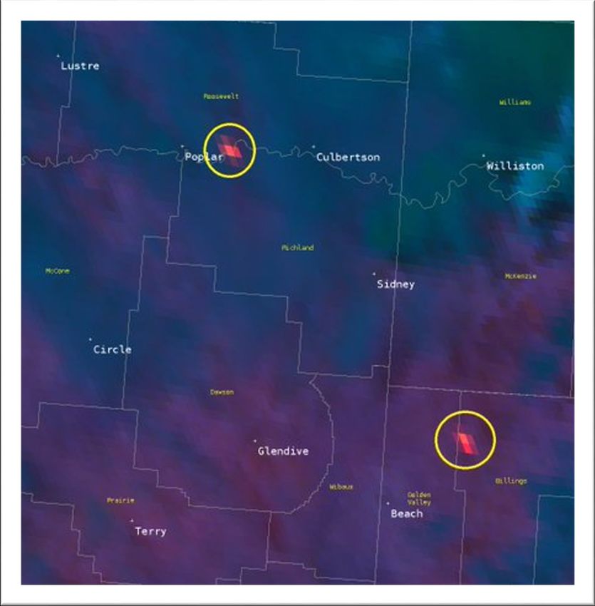
30 Day Percent of Normal Precipitation (Montana)
Recent Warm Season CoCoRaHS Training:
NWS Glasgow recently held a warm season CoCoRaHS
training for those interested in becoming a new ob-
server. The training is also a good reference for those
current observers
seeking a refresher.

CoCoRaHS is a grass-
roots organization
with a network of
dedicated observers                                              Figure 1: 30-day percent of normal precipitation across
who report daily pre-                                            Montana.

cipitation such as
rain, hail, or snow from all across the country. The data         Avg. Temp Departure from Normal (Montana)
are used by meteorologists, insurance adjusters, mos-
quito control, and even by those in academia.

Participating in the CoCoRaHS program is a great way
to make a difference in your community. Check out
the CoCoRaHS main page to learn more! We are still
accepting new observers so feel free to join through
the main CoCoRaHS website today. All you’ll need is a
ruler and a rain gage to get started!

                                                                Figure 2: 30-day temperature anomalies across Montana.

                                                                Summary: Drought concerns continue across NE
                                                                Montana where the 30 day percent of normal pre-
                                                                cipitation continues to trend well below average.
                                                                Meanwhile, temperatures have generally been
                                                                near to below normal over the last 30 days pretty
                                                                much across the state.

                                                            2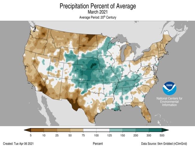
Hydrologic Summary for March 2021 by Greg Forester, Lead Forecaster at NWS Glasgow:

It was a drier and warmer than normal month for temperatures over Northeast Montana. The
wet spots were Cohagen with 0.39 inch, Zortman and Wolf Point with 0.35 inch, and Sidney
with 0.30 inch. The dry spots were Glasgow 46SW with 0.01 inch, Port of Morgan with 0.04
inch, Malta 7E and Winnett 12SW with 0.05 inch. Glasgow received 0.21 inch which was 45
percent of normal. Temperatures averaged between 5 degrees and 10 degrees above normal
across the region. Glasgow averaged 39.4 degrees which was 8.5 degrees above normal.

The dry weather has allowed severe drought to develop over the northeast half of the region
which includes areas east of Malta, Fort Peck, and Terry.

Stream flow on the Milk River was near normal in early March but fell to well below normal
during the second half of the month. The Yellowstone River was frozen for the first 2 weeks of
the month and had below normal stream flow after the ice broke up in the middle of the
month. The Missouri River was frozen until the ice broke up around March 20 and then had
near normal stream flow the remainder of the month. The Poplar River was frozen or partly
frozen the entire month.

The Fort Peck Reservoir elevation rose slightly to 2233.4 feet during the month. The reservoir
was at 78 percent of capacity and 99 percent of the mean pool.

                                              3
CPC Three Month Outlook:                                            U.S. Drought Monitor:
The Climate Prediction Center released an update of                 The latest U.S. Drought Monitor was released on
its three month outlook for temperature and precip-                 Thursday May 6, 2021. Much of NE Montana is now
itation for May through July back on May 6, 2021.                   under the influence of a severe to extreme drought.
The outlook calls for above average temperatures to                 This outlook is updated weekly. Please feel free to
be favored across the state. Unfortunately, though                  check out the latest here.
drought conditions continue across NE Montana, it
does look like the three month period ahead overall
does have a higher probability of being drier than
average. At least the current forecast points to in-
creased rain chances this weekend, so hopefully that
will provide some relief for now, but whether that
trend continues into the summer months is yet to
be seen. And when it comes to the forecast at least,
it does look like precipitation will most likely remain
below normal overall.
The latest outlook in full detail is always available
here. In addition, you can check out the Climate
Prediction Center Interactive site! You can zoom in
on our area, and navigate to see the climate outlook
for your specific location. The pie charts on the left
hand side can be particularly useful for assessing the
outlook at your specific location.

Figure 3: Climate Prediction Center three month temperature
(top) and precipitation (bottom) outlook for May 2021 through
July 2021.
                                                                        Figure 4: U.S. Drought Monitor updated May 6, 2021

                                                                4
U.S. & Global Climate Highlights (March): The
U.S. & Global climate highlights for March 2021 have
                                                                Social Media Highlight of the Month
been released, the latest month for which data was
available. A few points for you to take home are provid- Warm/dry weather and gusty winds on April 30 led
ed below.                                                to two large wildfires across the region that were
                                                                    picked up on satellite.

Figure 5: March 2021 Percent of Average Precipitation (U.S.).

U.S. Highlights for March 2021

1) The contiguous U.S. average temperature for March
   2021 was 45.5 °F, ranking within the warmest third                 Figure 6: Satellite imagery shared on NWS Glasgow social media on
   on record.                                                         April 30 when two large wildfires were detected during extreme
                                                                      fire weather conditions.
2) The average March precipitation total for the contig-
   uous U.S. came in at 2.45 inches. This ranks within
   the middle of the existing period of record.

Global Highlights for March 2021                                                        Links You May Like:
                                                                                        April ENSO Update
1) The March 2021 global land and ocean surface tem-
   perature was the 8th warmest February on record.                                 ENSO or Climate Change
2) There were no global land or ocean areas that expe-                    On the 1991-2020 U.S. Climate Normals
   rienced record breaking cold March temperatures.
                                                                        Atlantic Hurricane Season: A New Normal
3) La Niña continued to be present in March, but weak-
   ened in strength.

                                                                5
COOP Precipitation Data (*Preliminary* March 2021)

Station Precipitation    Location                  Station Precipitation     Location
   BAYM8            0.32             Baylor          MDCM8              0.12       Medicine Lake 3 SE
   BRDM8            0.19           Bredette          MLDM8              0.14              Mildred 5 N
   BTNM8              M      Brockton 17 N           MSBM8              0.14             Mosby 4 ENE
   BKNM8            0.22      Brockton 20 S          OPNM8              0.13             Opheim 10 N
   BKYM8            0.12 Brockway 3 WSW              OPMM8              0.16           Opheim 12 SSE
   BRSM8              M            Brusette           PTYM8             0.18              Plentywood
    CLLM8           0.17     Carlyle 13 NW           PTWM8              0.19         Plentywood 1 NE
   CIRM8             0.16             Circle         POGM8              0.04           Port of Morgan
  CHNM8              0.39           Cohagen           RAYM8             0.19 Raymond Border Station
    COM8             0.36     Cohagen 22 SE           SAOM8             0.06              Saco 1 NNW
  CNTM8              0.06      Content 3 SSE          SMIM8             0.07                 St. Marie
  CULM8              0.09         Culbertson          SAVM8             0.14                    Savage
  DSNM8              0.05       Dodson 11 N           SCOM8             0.20             Scobey 4 NW
   FLTM8             0.04   Flatwillow 4 ENE          SDYM8             0.04                    Sidney
   FPKM8             0.20       Fort Peck PP           SIDM8            0.30                 Sidney 2S
  GLAM8              0.11    Glasgow 14 NW            TERM8             0.14                     Terry
 GGWM8               0.21      Glasgow WFO            TYNM8               M             Terry 21 NNW
  GGSM8              0.01    Glasgow 46 SW             VIDM8              M                  Vida 6 NE
 GNDM8              0.14     Glendive WTP            WSBM8              0.27                   Westby
  HRBM8                M               Harb          WTRM8              0.15              Whitewater
  HINM8             0.23     Hinsdale 4 SW            WHIM8               M         Whitewater 18 NE
  HNSM8                M    Hinsdale 21 SW           WBXM8              0.06               Wibaux 2 E
 HOMM8              0.28    Homestead 5 SE           WTTM8                M                    Winnett
  HOYM8             0.15               Hoyt          WNEM8              0.09           Winnett 6 NNE
  JORM8                M             Jordan          WNTM8              0.13            Winnett 8 ESE
  LNDM8             0.17            Lindsay           WITM8             0.05           Winnett 12 SW
 MLAM8              0.07              Malta           WLFM8             0.35                Wolf Point
  MLTM8             0.05         Malta 7 E            ZRTM8             0.33                  Zortman
 MTAM8              0.01        Malta 35 S

                                               6
COOP Precipitation Data (*Preliminary* April 2021)

Station Precipitation    Location                  Station Precipitation     Location
   BAYM8              M              Baylor          MDCM8              0.42       Medicine Lake 3 SE
   BRDM8            0.26           Bredette          MLDM8              0.24              Mildred 5 N
   BTNM8              M      Brockton 17 N           MSBM8              0.32             Mosby 4 ENE
   BKNM8              M       Brockton 20 S          OPNM8                M              Opheim 10 N
   BKYM8            0.24 Brockway 3 WSW              OPMM8              0.07           Opheim 12 SSE
   BRSM8              M            Brusette           PTYM8             0.53              Plentywood
    CLLM8             M      Carlyle 13 NW           PTWM8                M          Plentywood 1 NE
   CIRM8             0.17             Circle         POGM8              0.16           Port of Morgan
  CHNM8              0.42           Cohagen           RAYM8               M Raymond Border Station
    COM8               M      Cohagen 22 SE           SAOM8             0.45              Saco 1 NNW
  CNTM8              0.32      Content 3 SSE          SMIM8             0.22                 St. Marie
  CULM8              0.33         Culbertson          SAVM8               M                     Savage
  DSNM8                M        Dodson 11 N           SCOM8             0.10             Scobey 4 NW
   FLTM8             0.83   Flatwillow 4 ENE          SDYM8             0.38                    Sidney
   FPKM8             0.29       Fort Peck PP           SIDM8            0.23                 Sidney 2S
  GLAM8              0.35    Glasgow 14 NW            TERM8             0.39                     Terry
 GGWM8               0.43      Glasgow WFO            TYNM8               M             Terry 21 NNW
  GGSM8              0.95    Glasgow 46 SW             VIDM8              M                  Vida 6 NE
 GNDM8              0.18     Glendive WTP            WSBM8                M                    Westby
  HRBM8                M               Harb          WTRM8              0.22              Whitewater
  HINM8             0.76     Hinsdale 4 SW            WHIM8               M         Whitewater 18 NE
  HNSM8                M    Hinsdale 21 SW           WBXM8              0.63               Wibaux 2 E
 HOMM8                 M    Homestead 5 SE           WTTM8                M                    Winnett
  HOYM8                M               Hoyt          WNEM8              0.26           Winnett 6 NNE
  JORM8                M             Jordan          WNTM8                M             Winnett 8 ESE
  LNDM8             0.43            Lindsay           WITM8               M            Winnett 12 SW
 MLAM8              0.41              Malta           WLFM8             0.17                Wolf Point
  MLTM8             0.49         Malta 7 E            ZRTM8             1.56                  Zortman
 MTAM8                 M        Malta 35 S

                                               7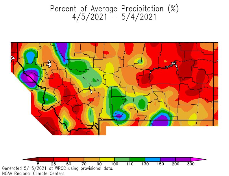
Monthly Trivia:
Last time we asked…
New Question: As spring and summer get underway, so does increasing recreation on Fort Peck Lake!
NWS Glasgow issues many products to help keep you safe out on your adventures, such as a Lake Wind Advi-
sory during those breezy days! Our question this month, what is the Criteria for when a Lake Wind Advisory
is officially hoisted?

Answer: A Lake Wind Advisory is issued for sustained wind speeds of 20 MPH or greater for three consec-
utive hours or ANY gust in excess of 30 MPH. You can always check the latest forecast from NWS Glasgow
before you head out on the lake.

             Figure 7: Fort Peck Lake/boating safety campaign graphic.

     New Question: Convective thunderstorm season is upon us! This month we ask: What’s the differ-
     ence between a watch and a warning? We’ll share the answer to this as well as some additional im-
portant safety information in the next newsletter edition!

Find us on Facebook, Twitter and YouTube! No account needed:

                                                            8
You can also read