Update on BeiDou Navigation Satellite System and PNT System - Stanford 2019 PNT Symposium National Time Service Center Chinese Academy of Sciences
←
→
Page content transcription
If your browser does not render page correctly, please read the page content below
Update on BeiDou Navigation
Satellite System and PNT System

LU Xiaochun

30th, October, 2019

Stanford 2019 PNT Symposium
National Time Service Center Chinese Academy of Sciences
01    BDS System Construction
CONTENT

          02   Application and Cooperation

          03   Comprehensive PNT System
From Compass to Global Satellite Navigation
Systems (GNSS), Positioning, Navigation and Timing
Technology (PNT) has made brilliant achievements. It has
promoted the progress and development of human
society as well the explorations of the world.
01
BDS System Construction
1. GNSS System Construction
       Global Navigation Satellite Systems
        Global Systems               Regional Systems

USA:
GPS
        Russia:
       GLONASS
                  China:
                   BDS
                            EU:
                           Galileo   +   Japan:

                                         QZSS
                                                  India:

                                                  NavIC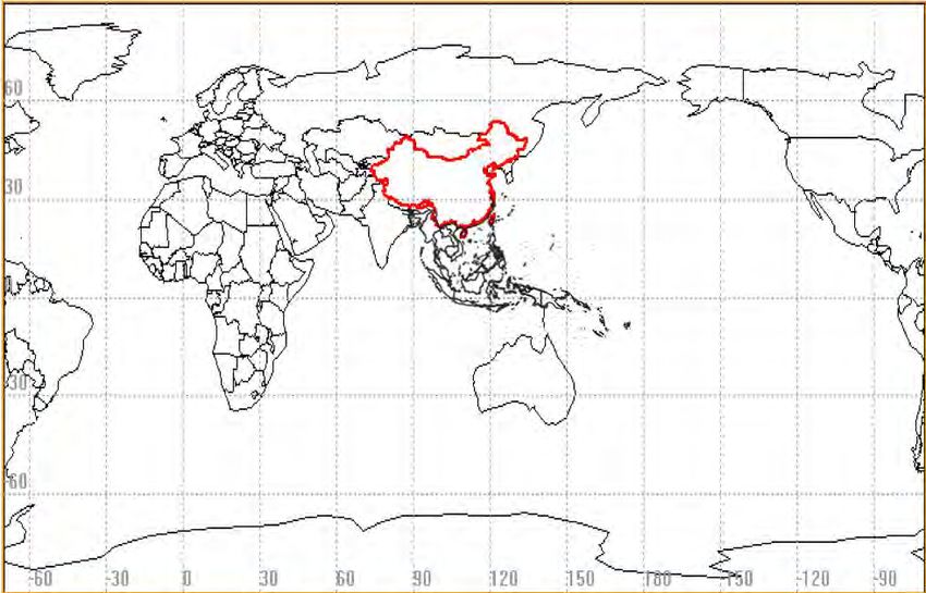
1. GNSS System Construction
     There are nearly 100 satellites in orbit of other
              major systems in the world

The current quantity of satellites in orbit of each system

       GPS                              31

    GLONASS                             24
     Galileo                            22
      QZSS                               4
     NavIC                               7
      Total                             88

  PS. Beidou Satellites and in-orbit test and maintenance
                satellites are not included.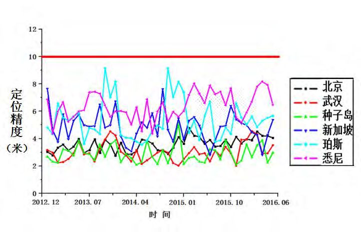
2. BDS Strategy and Principle
    Three-step strategy of development:
                     Regional to Global,Active to Passive
    Principle:Independence, Openness
                      Compatibility, Gradualness
 1st step:BDS-1, 1994~2000,Regional active                3rd step:BDS-3,2013~2020 ,Global passive

l Limited capacity                                        l Precision Improved availability and reliability
                                                            enhancement
l Timing, Positioning, Short message
  communication                                           l RNSS, SMS, SBAS, SAR, PPP

                        第一步                         第二步                     第三步

                             2nd step:BDS-2, 2004~2012, Regional passive
                             l Unlimited capacity                                                             7
                             l RNSS, SMS, Wide Area Differential Service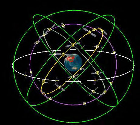
2. BDS-2 System Consruction
    (1) The system runs continuously and stably
          Operational without service interruption
          meet service requirements for public and
                   international users

                                       B1I Horizontal Position Accuracy

Service interruption time (hours)   Continuous service rate

               0                               100%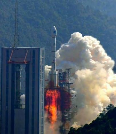
3. BDS-3 System Construction

 23 BDS-3 satellites have been successfully launched

     In-orbit testing, system integration and performance
 evaluation of the satellites are underway, preliminary results
 show that the satellites are in good condition and the
 performance meets the promise.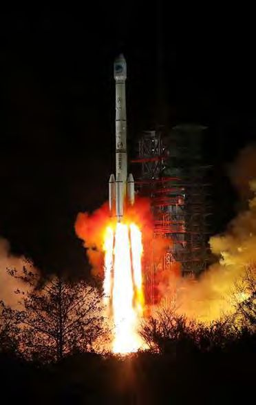
3. BDS-3 System Construction
       (1) Summary of Assessment Results
Index                           Assessment Results                   Requirements
UTCOE /ns                                  13.5                         ≤20.0
                         B1C:-155.04 B1I:-156.02 B2a:-153.14 B2b:-
Power/dBw                                                                ——
                                  153.83 B3I:-155.49
SCB/ns                                      0.3                          ——
SISRE/m                                    0.48                          ≤0.6
Orbit Accuracy of
                                        radial 0.06                      ——
Broadcast /m
Clock Bias Accuracy
                                        mean 1.57                        ——
of Broadcast /ns
Intersatellite Ranging
                                         mean 0.1                        ——
Accuracy/ns
Satellite Clock                  Rubidium Clock 1.62x10⁻¹⁴
                                                                         ——
Performance                     Hydrogen Clock 5.21x10⁻¹⁵
SISRRE/(m/s)                              0.0009                        ≤0.006
SISRAE/(m/s2)                             0.0003                        ≤0.002
Spatial Signal
                                         99.78%                         ≥98.0%
Availability
3. BDS-3 System Construction
(1) Summary of Assessment Results
Index Assessment Results Requirements
Spatial Signal
99.99%/h 99.8%/h
Continuity
PDOP Availability 85% ≥85.0%
Horizonal better than 6.0m
Positioning Accuracy ≤10.0(PDOP≤6)
Vertical better than 10.0m
UERE/m Better than 1.8 ——
Ionospheric Model
Scale-correction ≥ 65% ——
Accuracy
Velocity Horizonal better than 0.07
——
Accuracy/(m/s) Vertical better than 0.10
Timing Accuracy/ns 19.1 ≤20
Positioning Availability Better than 91% ≥85.0%
Summary of Assessment Results3. BDS-3 System Construction
(2) BDS-3 Five Major Services
Signal
Service Type Satellite
Frequency
B1I, B3I,
3IGSO+24MEO
RNSS B1C, B2a
B1I、B3I 3GEO
SBAS BDSBAS-B1C、
3GEO
BDSBAS-B2a 5 services
L(Uplink)
Reginal 3GEO
Short S(Downlink)
3 regions
Message
L(Uplink) 14MEO
Communicati
on Service Global
B2b
3IGSO+24MEO Asia-Pacific
(Downlink)
UHF(Uplink) 6MEO
International Search
and Rescue Service
B2b
(SAR) 3IGSO+24MEO
(Downlink)
Precisise Point
B2b 3GEO
Positioning(PPP)
Key area:30°E~180°E,70°N~70°S
China and surrounding areas:75°E~135°E,10°N~55°N3. BDS-3 System Construction
(2) BDS-3 Five Major Services-RNSS Service (Global)
l Excellent performance
l Compatible and Interoperable
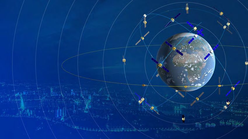
BDS B1C/B2a Signals
B2a B1C
BDS L5 L1 L1C
C/A
GPS E5a E1 OS
Galileo 1176.45 MHz 1575.42MHz3. BDS-3 System Construction (2) BDS-3 Five Major Services-RNSS Service (Global) Ø B1I, B3I : l System Service Availability : > 99% l Positioning Accuracy: 3.6 meters horizontally, 6.6 meters vertically (95%) l Velocity Measurement Accuracy: 0.05m/s, l Timing Accuracy: 9.8ns(95%) l In the Asia-Pacific region, the positioning accuracy and availability increased about 30% and 5% respectively.
3. BDS-3 System Construction
 (2) BDS-3 Five Major Services-RNSS Service (Global)
Ø B1C, B2a :
l Global Coverage, Availability>87%;
l Positioning Accuracy: 2.4 meters horizontally, 4.3 meters vertically
l Velocity Measurement Accuracy: 0.06m/s
l Timing Accuracy: 19.1ns(95%)
3. BDS-3 System Construction
 (3) BDS-3 Five Major Services-Short Message
     Communication Service (Regional)
                         Service Planning:
                       l 3GEO
                       l Two-way links
                       l Serve China and surrounding areas
                       l Service volume:increases by 10 times
                       l User's transmit power is 1-3w
                       l 1000 Chinese characters per message

                          Construction Progress:

                       l Launched: 1 GEO
                       l Underway: in-orbit technical tests
3. BDS-3 System Construction
(3) BDS-3 Five Major Services-Short Message
Communication Service (Global)
Service Planning:
l 14 MEO
l Global casual access
l Service capability is 40 Chinese characters per
message (560 Bytes)
Construction Progress:
l Launched: 10 short-message-communications-
loaded MEO satellites
l Underway: in-orbit technical tests3. BDS-3 System Construction
(4)BDS-3 Five Major Services-International SAR
Service(Global)
Service Planning:
l 6 MEO
l Global Services
l Compliance with standards of the
International Maritime Organization
(IMO) and COSPAS/SARSAT
l Return-links, improve the efficiency
Construction Progress:
l Launched:4 SAR-loaded MEO satellites
Distress SAR mission Rescue
beacon control center center
l Underway: in-orbit technical tests3. BDS-3 System Construction
(5) BDS-3 Five Major Services-Satellite-Based
Augmentation Services (SBAS)
Service Planning:
l 3 GEO( 80°E(Nov. 2018),110.5°E,
140°E (2020) )
l Following the ICAO standards and
realizing precision service according to
CAT-I
l China and surrounding areas
Construction Progress:
l Launched: 1 GEO
l Underway: in-orbit technical tests
Information dissemination test3. BDS-3 System Construction
(5) BDS-3 Five Major Services-Satellite-Based
Augmentation Services (SBAS)
BDSBAS
Performance DFMC( Dual Frequency
SF(Single Frequency)
Multi-Constellation)
Service Coverage 10°N~55°N;75°E~135°E 10°N~55°N;75°E~135°E
BDS B1C/B2a
BDS B1C GPS L1C/A/L5
Augmentation Constellation GPS L1C/A GALILEO E5a/E1
GLONASS L1/L2/L3
Frequency 1575.42MHz 1176.45MHz
Signal Signal Structure SBAS L1 C/A DFMC SBAS L5
H:2.5m H:1.5m
Accuracy(95%) V:4m V:2m
Time To
10s 6s
Alarm
Integrity Integrity Risk 2×10⁻⁷/150s 2×10⁻⁷/150s
HAL:40m HAL:40m
Alarm Threshold
VAL:50m VAL:10m
Continuity 1-8×10⁻⁶/15s 1-8×10⁻⁶/15s
Availability Better than 99% Better than 99.9%
Compatibility SF SBAS ICD DFMC SBAS ICD
User capacity Unlimited
The Performance of BDSBAS3. BDS-3 System Construction
(6) BDS-3 Five Major Services-Precise Point
Positioning service (PPP)
Service Planning:
l 3 GEO
l Serve China and surrounding areas
l Dynamic precise position service
accuracy at decimeter level and static
precise position service accuracy at
centimeter level
Construction Progress:
l Launched: 1 GEO
l Underway: in-orbit technical tests and
Information dissemination test3. BDS-3 System Construction
(7) Construction of Ground Facilities-National
Differential System
Service Perencialng:
l 175 framework constellation reference stations,
1200 regional network reference stations
l China and most maritime area
l Satellite broadcasting, digital broadcasting and
mobile communication broadcasting
l wide-area at meter level and decimeter level, area
at centimeter level and post-processing at
millimeter level
Construction Progress:
l More than 2,200 reference stations
l Three broadcasting means
l Services at the wide-area meter in the whole country and sub-meter levels3. BDS-3 System Construction
(8) Construction of Ground Facilities-International
GNSS Monitoring and Assessment System
Service Planning:
l 30 Global Reference Station
90 N
l 3 data centers 黄河站
奥布宁斯克
伊尔库茨克
卡尔加里 布伦瑞克
伦敦 长春 堪察加
45 N 乌鲁木齐
l 10 analysis centers 阿尔及尔 拉萨
西安 北京
武汉
上海
卡拉奇 昆明
康提
l Raw observation data, basic high-precision products
0
180 W
135 W
90 W
贝伦
45 W
0
阿布贾
45 E
90 E
新加坡
135 E
180 E
达尔文
塔西提
(precision orbit, clock difference, ionosphere, earth
里约热内卢
复活节 布宜诺斯艾利斯 堪培拉
赫曼努斯 珀斯
45 S
rotation parameters, etc.), monitoring and evaluation 中山站
information (constellation status, space signal,
90 S
navigation information, service performance)
Construction Progress:
l An international Monitoring and Assessment System
l Related data and products are available at www.csno-tarc.cn3. BDS-3 System Construction
(9) Smooth Transition from BDS-2 to BDS-3
System Evolvement
BDS-2 BDS-3
Area Regional Global
RNSS, RDSS, Wide Area RNSS、SMS(including RDSS)、
Type
Differential SBAS、SAR、PPP
Constellation 5G+5I+4M 3G+3I+24M
RNSS Signal 6 8
RDSS Signal Old system Old system + New system
Positioning accuracy 10m
Positioning accuracy 10m
Performance URE 0.5m
URE 2.5m
…….3. BDS-3 System Construction
(9) Smooth Transition from BDS-2 to BDS-3
A l Guarantee interests of existing users
Existing user service of BDS-2 will not be interrupted
I
l Provide quality service as soon as possible.
M New users will give priority to use of BDS-3 service to shorten
S transition period
l The signal is the basis
Signal is upgraded in an incremental manner, and BDS-3 retains
main signals of BDS-2
K
E l The constellation is a guarantee
Y On any time profile, DOP value will not decrease
S
l Ground segment is the core
Ground system of BDS-2 and BDS-3 can work together and joint
operate3. BDS-3 System Construction
(10) Construction Process
launched:
2018-2019.10 Dec.2018
•20 MEO satellites
Completed the primary system of
•1 GEO satellite
BDS-3 and provided operational
•2 IGSOsatellites service to the global users
From 2019.10 •4 MEO satellites Dec.2020
To 2020 •1 IGSOsatellite Complete full constellation and
•2 GEO satellites global coverage02 Application and Cooperation
1. Applications Promotion
       (1) Industrial and Regional Applications
      BDS-enabled products have been widely used in traffic & transportation,
public security, agriculture, forestry and fishing, hydrologic monitoring, weather
forecast, communications system, generation dispatch and disaster response & relief,
as well as national core infrastructure, which has greatly increased economic and
social benefits.

                                                                                 17
1. Applications Promotion
(2) Applications in Traffic and Transportation
l The world's largest dynamic monitoring
system for operational vehicles has been
built
l 6.2 million operational vehicles
l 30,000 postal and delivery vehicles
l 80,000 buses
l Over 3200 inland waterway navigation
facilities
l Over 2900 marine navigation facilities1. Applications Promotion
(3) Applications in Agriculture, Forestry and Fishing
l Serve over 50,000 agricultural
equipment
l Precision farming output has increased
by 5%
l Income growth of RMB 60- 90 pe r
month per peasant household
l Po s i t i o n i n g & s h o r t- m e s s a g e
communication function help prevent
forest fires
l Over 70,000 networked boats
l Has rescued over 10,000 people1. Applications Promotion
(4) Applications in Disaster Response and Relief
l 6 levels of business applications
l Over 45,000 BDS terminals have
been promoted
l Relevant disaster response
information has been reported
l Disaster relief materials management
has been improved1. Applications Promotion
(5) Mass Market Applications
In terms of mass-market applications, the BDS-based navigation services have been
adopted by e-commerce, mobile intelligent terminal manufacturing and location-based
service manufacturers. In the meanwhile, it has entered into mass consumption, shared
economy and people’s livelihood, as well as affected peoples' lifestyles in a profound way.1. Applications Promotion
(5) Mass Market applications
According to statistics, around 470 types of smartphones sold in the first three
quarters in China have a positioning function, among them 298 support BDS
positioning, which is accounting for 63% of the total. A wide range of BDS-based 22
smart wearable devices such as watches, bracelets and care products such as student
cards and senior citizen cards keep popping up and have been used widely.1. Applications Promotion
(6) Strategic Emerging Industries——”BeiDou +”
Next, we will focus on promoting the integrated development of BeiDou with the
Internet, cloud computing, Internet of things,ar tificial intelligence, 5G mobile
communications and other tehnologies.International Cooperation Open Cooperation Resource Sharing
2. Internationa Cooperation
       (1) Bilateral Cooperation——China-US Cooperation

   On Nov. 29, 2017, China and the U.S. signed a Joint statement on Civil Signal
Compatibility and Interoperability between GPS and BDS.
2. International Cooperation
(2) Multilateral Cooperation
The 13 th ICG Conference was successfully held in November 2018
following the 7th ICG Conference in 2012. Manual on GNSS Space Service
Interoperability was launched during the Conference and Xi’an Initiative
was also agreed during the Conference.03 Comprehensive PNT System
Humans Keep Looking for Better
Navigation and Positioning Methodologies
         Two Driving forces:Demand & Technology
     Full and high performance
     coverage of sea, land and air
     Systematic Construction
     Human activities in surface                                5th Stage      M-PNT
     and near space with Satellite                                                Quantum
     Navigation As the Core                                                       Navigation
                                                   4th Stage       Satellite
   Remote land, sea and air                                       Navigation           Pulsar
         transport                                                                     Navigation
                                                        Matching Navigation
    Radio and Electronics                   3rd stage
                                                        Inertial Navigation
                                                                                            ……
Ocean voyage, colonial                                     Speedometer
development                     2nd Stage   Sextant            Astronomical
Simple instrument to                                           navigation
observe natural phenomena     1st Stage
                                            Navigation
                                                                Atomic clock
                                            Clock
   Human migration ,           Compass                          Quartz clock
   hunting and farming
   Visual observation of
    natural phenomena
1. The Current Difficulties
(1) The weakness of Satellite Navigation
l Weak signal, Susceptible to interference, easy to
be blocked by tall buildings and mountains
l Poor penetration: underwater, indoor and urban
canyons cannot be covered
l Unable to provide interstellar navigation
l Depend on the ground facilities
How can we solve this problem?2. System Construction of PNT System
(1) Basic Definition
What is Comprehensive PNT?
spatio-temporal
information
transmission
spatio- PNT
temporal spatio-temporal
System
PNT capacity
information
information
Theory and method
PNT Information
Theory and method spatio-
temporal
spatio- Theory and method
information
temporal
PNT Technology
Nature
Light, electricity, sound, PNT Service
magnetism, gravity
Comprehensive PNT technology is the generic name of various
PNT technologies, systems and services, covering and penetrating
the whole process of establishment, maintenance, transmission and
application of spatio-temporal reference, providing unified, accurate
and reliable spatio-temporal information service for human activity
space.2. System Construction of PNT System
(2) Prospect of the Development
It's expected to be built into a national comprehensive PNT system by 2035
more ubiquitous, more integrated ,more intelligent,
Low-
orbit Space-
Indoor augme based
navigati ntation augme
on ntation
Underw Ground
ater -based
navigati augme
on ntation
Satellite
Navigation
Celestial
navigati INS
on
Quantu
Loran-C
m
navigati
navigati
on …… on2. System Construction of PNT System
(6) Key Application Field
Unified, Real-time, Accurate PNT Information
Scientific and
National Security Economic and
Technological
Governance Social Development
Progress
• All things • Transportation, • The Internet
connected • The Internet of
communication
• Information things
sharing • Finance, logistics • Big data
• Accurate • Infrastructure • Cloud
perception computing
• Accurate • Artificial
operation intelligence (AI)Conclusion
The global satellite navigation systems are changing rapidly.
In particular, with the four global systems and two regional
systems, the number of orbiting satellites has increased to more
than 100. The service has improved dramatically and has
provided more options for users.
BDS will play a more active role in serving mankind and the
world and keep contributing wisdom and strength to the world
with its stronger abilities and better-quality services.Thanks for your listening!
You can also read