USING STEREO MATCHING 3D MODELS IN MONITORING HYDROTECHNICAL TORRENT CONTROL STRUCTURES
←
→
Page content transcription
If your browser does not render page correctly, please read the page content below
Bulletin of the Transilvania University of Braşov
Series II: Forestry • Wood Industry • Agricultural Food Engineering • Vol. 4 (53) No. 2 - 2011

            USING STEREO MATCHING 3D MODELS
             IN MONITORING HYDROTECHNICAL
              TORRENT CONTROL STRUCTURES

                                I. CLINCIU1                      M.D. NIŢĂ1

                 Abstract: The usage of terrestrial photogrammetry is also known
                 nowadays, in most of cases, as terrestrial scanner application. In this paper a
                 stereo matching 3D algorithm is presented in order to use it in monitoring
                 the torrent control structures. The present paper objective is to highlight the
                 possibilities of terrestrial photogrammetry. In the studied case, a 3D model
                 of a masonry dam has been extracted from several paired photos. The main
                 conclusion of the study is that the methodology represents a future step in
                 monitoring the hydrotechnical structures.

                 Key words: 3D model, monitoring, hydrotechnical structure.

1. Introduction                                         2. State of the Art in 3D Surface
                                                           Reconstruction
  The use of 3D information in monitoring
hydrotechnical torrent control structures is              For many decades the 3D surface
not a new idea [11]. Several studies on                 reconstruction has been researched and
extracting 3D models revealed the                       analyzed starting from pioneers like M.J.
facilities of this kind of study [1], [2].              Hannah with his Ph.D. Thesis Computer
  The methods used in surface reconstruction            Matching of Areas in Stereo Images in
nowadays are either time consuming                      1974 and continuing with many others.
(topographical measurements of feature                  Still the problem is far from being
characteristics), either expensive (laser               completely solved due to many sources of
scans). From this point of view there is a              errors. Most state-of-the-art methods rely
large demand on cheaper and easier ways                 on first using local measures to estimate
of 3D reconstruction.                                   the similarity of pixels across images and
  Extracting 3D models using only a                     then on imposing global shape constraints
camera definitely resolves both problems                using dynamic programming, level sets,
on time consumption and high costs with                 space carving, graph-cuts, PDE or EM [6].
traditional methods.                                      The problem of using many of the
  The usage of a web based 3D                           methods and algorithms in 3D surface
reconstruction service with a user friendly             reconstruction remains the descriptors used
interface offers the technical support for              in stereo pair matching. The power of
users from other domains, like forest                   algorithm itself is enhanced by the pairs
engineers.                                              identified with the descriptor. The descriptor

1
    Dept. of Forest Management Planning and Terrestrial Measurement, Transilvania University of Braşov.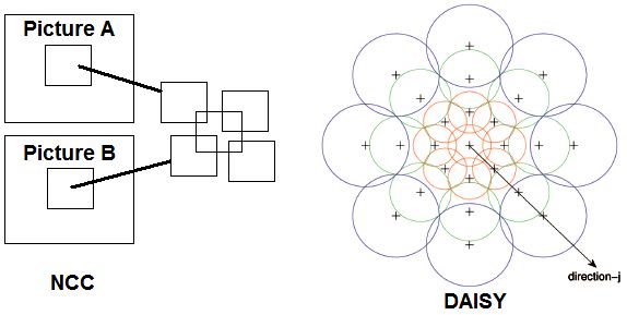
8           Bulletin of the Transilvania University of Braşov • Series II • Vol. 4 (53) No. 2 - 2011

itself is a mathematical distance function         NCC or Daisy. The difference between the
of searching matching points in the                descriptors is given either by the radius of
pictures. The most common descriptors              search or by the direction of the function
used in 3D reconstruction are SIFT, SURF,          (Figure 1).

    Fig. 1. Comparing different descriptors with ground truth (first laser scan, second
                                 DAISY, third NCC) [6]

3. Material and Method                             (Figure 4) and reconstructs the x, y, z
                                                   coordinates of a pixel after triplet matching
  In the hydrotechnical structures monitoring      (Figure 5). The matching of the triplets is
activity, several parts (e.g. apron, spillway,     mathematical similar with a triangulation
wings etc.) are taken into consideration for       and consists in finding triplets with enough
characterising     the      behaviour      and     matches between both images 1 and 2 and
dysfunctionality of the works [3-5].               images 2 and 3.
  In this activity the tri-dimensional
characteristics of the component parts are
mandatory. The 3D model of the
hydrotechnical structures solves the problem
of measuring the characteristics in the
field.
  The method consists in taking pictures of
the hydrotechnical structure from different
positions which cannot exceed a 12 degree
parallax angle [9], [11] (Figure 2).
  For taking the images for hydrotechnical
structures a CANON EOS camera was used.
  The pictures are stereo-paired using the
NCC descriptor.
  The NCC descriptor uses at first pairs of        Fig. 2. The projection of a 3D object point
pixels located in two separate pictures                     Pj in the camera image [8]
Clinciu, I., et al.: Using Stereo Matching 3D Models in Monitoring Hydrotechnical … 9
Fig. 3. 3D reconstruction of some characteristics of the dam based
on 3 images stereo-restitution10 Bulletin of the Transilvania University of Braşov • Series II • Vol. 4 (53) No. 2 - 2011
Fig. 4. The NCC and DAISY descriptor matching methods
The 3D model reconstruction is based on 4. Results and Discussion
creating a network of irregular triangles
(TIN) also called meshes from the points The complexity of the 3D model
calculated with NCC descriptor. reconstructed from pictures using NCC is
influenced by the number of the pictures
used in calculation, the angle between
picture views and picture resolution.
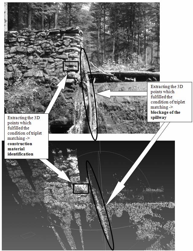
As shown in the application (Figure 3),
the 3D model offers a lot of real scale
information about the status of the
hydrotechnical structure.
For example:
Fig. 5. Identifying pixels 3D coordinates • Easy identification of component parts
using triplet matching [7] which has been affected by diverse
behavioural events during the functioning
The position of the camera is not period (in this case: the central spillway
influencing the algorithm [10]. In addition zone, left wing of the watershed);
if the differences between the camera • Accurate reconstruction of the adopted
positions are small, the pictures contribute constructive solution;
to a better identification of the paired pixels. • Precise identification of construction
material (in this example: the masonry);
• Identification in the left part of the
model of the affected parts by disaggrega-
tion;
• Identification in the lower part of parts
affected by water erosive degradation;
• Positioning the floating elements
which are blocking the apron and the
spillway;
• Possibility of establishing the blocking
proportion of the spillway.
This kind of usage of photographs is a
new approach in monitoring the torrent
Fig. 6. Irregular position of the camera [7] control hydrotechnical structures and researchClinciu, I., et al.: Using Stereo Matching 3D Models in Monitoring Hydrotechnical … 11
must be conducted in the future to better References
quantify the advantages and disadvantages
of the method. 1. Clinciu, I., Petriţan, C., Niţă, M.D.:
Using minimum logistic support (photo Monitoring of the Hydrotechnical
camera, open-source software, laptop) there Torrent Control Structures: A Statistical
were extracted 3D characteristics similar to Approach. In: Environmental
products extracted with expensive scanners. Engineering and Management Journal
Taking into consideration the case 9 (2010) No. 12, p. 1693-1701.
presented above, strong and weak points 2. Clinciu, I., Lazăr, N.: Efectele
have been identified. lucrărilor de amenajare a bazinelor
As strong points there can be mentioned: hidrografice torenţiale (Effects of
• Low costs; Torrential Watershed Management
• Fast application and extraction of 3D Works). In: Revista de Silvicultură 2
model; (1997), p. 12-18.
• High precision of the model; 3. Clinciu, I., et al.: Efectele lucrărilor de
• Easy usage in the field; amenajare a reţelei hidrografice
As weak points there can be mentioned: torenţiale din bazinul superior al
• The algorithm may introduce unreal Tărlungului - amonte de Acumularea
information; Săcele (Effects of the Torrential
• Manipulation of the model needs Hydrographic Network Management
experimented users; Works from Upper Tărlung Watershed-
• Scale of the model can be affected by Upstream of Săcele Accumulation). In:
errors. Research Contract no. 33 369, between
Transilvania University of Braşov and
5. Conclusions Ministry of Education and Research,
2004.
The present paper objective was to 4. Clinciu, I., Gaspar, R.: Cercetări
highlight the possibilities of terrestrial privind funcţionalitatea lucrărilor
photogrammetry, based on simple tools hidrotehnice de amenajare a torenţilor
and clever algorithms of stereo-restitution. (Research Regarding the Functionality
The explained technique in this paper of the Torrents’ Control Works). In:
can be promoted and successfully applied Revista Pădurilor 5 (2006), p. 3-9.
to torrent control hydrotechnical structures 5. Gaspar, R.: Norme tehnice pentru
monitoring. The method itself doesn’t need urmărirea comportării în timp a
expensive logistics or superior training of lucrărilor de construcţii folosite în
the operator who takes the pictures. amenajarea torenţilor (Technical
The proposed technique is suitable both Norms Regarding Behaviour of the
for evaluating the physical status of the Torrents’ Control Works). Bucharest.
structures during field trips and for ICAS - Ministry of Forestry, 1984.
estimating temporal dynamics of behavioural 6. Tola, E., Lepetit, V., Fua, P.: DAISY:
events repeating the action. An Efficient Dense Descriptor Applied
to Wide-Baseline Stereo. In: IEEE
Acknowledgements Transactions on Pattern Analysis and
Machine Intelligence 32 (2010) No. 5,
This paper was supported by CNCSIS- p. 815-830.
UEFISCSU, project number PNII-IDEI code 7. Vergauwen, M., Van Gool, L.: Web-
ID_740/2008. base 3D Reconstruction Service. In:12 Bulletin of the Transilvania University of Braşov • Series II • Vol. 4 (53) No. 2 - 2011 Machine Vision and Applications 17 Algorithms: Theory and Practice, (2006), p. 411-426. LNCS 1883 (2000), p. 298-372. 8. Thormählen, T., Hasler, N., Wand, M., 10. Xiang-Zhou, X., Hong-Wu, Z., Seidel, H.P.: Registration of Sub- Ouyang, Z.: Development of Check- Sequence and Multi-Camera Dam Systems in Gullies on the Loess Reconstructions for Camera Motion Plateau. In: China Environmental Estimation. In: Journal of Virtual Science & Policy 7 (2004), p. 79-86. Reality and Broadcasting 7 (2010) No. 11. Zhang, Z.: Parameter Estimation 2, p. 1-11. Techniques: A Tutorial with 9. Triggs, B., McLauchlan, P., Hartley, Application to Conic Fitting. In: Image R., Fitzgibbon, A.: Bundle Adjustment: and Vision Computing 15 (1997) No. A Modern Synthesis. In: Vision 1, p. 59-76.
You can also read