Main challenges of space-based forestry measurements and applications: the UK perspective - Juan C. Suárez - Suarez
←
→
Page content transcription
If your browser does not render page correctly, please read the page content below
Main challenges of space-based
 forestry measurements and
applications: the UK perspective

 Juan C. Suárez
 Centre for Forest Resources & Management
 Forest Research, Roslin, UK

 email: juan.suarez@forestry.gsi.gov.uk
Summary – current challenges in British forestry

• Monitoring processes of forest Decline and degradation in Britain

• Biotic hazards - Impact of diseases and pests

• Abiotic hazards – wind damage

• Monitoring productivity

• Monitoring stress

• A wish list

 2 30 June 2016 www.forestry.gov.uk/ForestResearch
Forestry in GB
• Resources geographically extensive and remote and
 reduced staff capabilities for field monitoring

• New challenges confronting forest managers that require
 access to new types of data if wood supply is maintained

• Need to address three fundamental questions:
 – What is growing where?
 – What is its condition?
 – Can forests be managed sustainably?

3 30 June 2016 www.forestry.gov.uk/ForestResearch
Climate change scenarios
Climatic suitability – Scots pine http://www.forestdss.org.uk/geoforestdss/esc4.jsp

 2014 2050 2080
4 30 June 2016 www.forestry.gov.uk/ForestResearch
Climate change scenarios
Climatic suitability – Sitka spruce http://www.forestdss.org.uk/geoforestdss/esc4.jsp

 2014 2050 2080
5 30 June 2016 www.forestry.gov.uk/ForestResearch
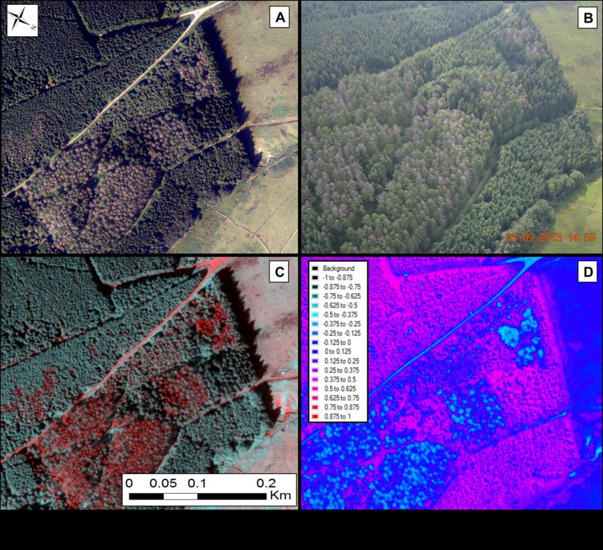
Current monitoring of diseases
 Phytophthora ramorum in larch plantations. Glen Trool 2012-2013
First found in Scottish plant nurseries in 2002 and in gardens/parks in 2007,
ramorum is causing extensive damage and mortality to larch trees. Mainly
affecting South West Scotland, by the end of 2013, approximately 5000 - 6000
ha of larch is thought to have been infected

6 30 June 2016 www.forestry.gov.uk/ForestResearch
Abiotic hazards, wind damage

 Endemic Catastrophic Human Impact

 Date Location Area affected Max Wind Total volume
• C. 4-30% never recovered (km2) speed (ms-1) damaged (in
 Million m3)
• Degradation of TQ 31/1/53 NE Scotland 370 48 1.8
• Increasing harvesting 15/1/68 Central 510 51 1.6
 costs Scotland
 2/1/76 Wales/Central 890 46 1.0
 England
 16/10/87 SE England 220 50 3.9
 25/1/90 SW England 690 47 1.3
 26/12/98 S Scotland 430 41 0.8
 8/1/05 N England undetermined 45 0.16
 11/1/05 NW Scotland undetermined 43 0.40

 7 30 June 2016 www.forestry.gov.uk/ForestResearch
Some considerations about the use of RS
 RS should have the capability
 of delivering carto products
 • ASAP
 • When somebody can do
 something about!!!

 • The nature of the
 phenomena being observed
 • Sensor characteristics
 • Scale factors
 • Temporal resolution
 • Cost
 • Expertise, tools…

 Source: Chloe Barnes

8 www.forestry.gov.uk/ForestResearch
Direct monitoring RS application for monitoring changes and updating NFI RNIR RRed NDVI EU-GMES RNIR RRed + NFI polygons 9 30 June 2016 www.forestry.gov.uk/ForestResearch
Monitoring windthrow

 Monitoring Forest Health

10 30 June 2016 www.forestry.gov.uk/ForestResearch
Low stocking

 Changes in land use

11 30 June 2016 www.forestry.gov.uk/ForestResearch
Source: TimeSync, Warren Cohen USFS

 www.forestry.gov.uk/ForestResearch
1st Point: we need more frequent and
 compatible satellite imagery

13 30 June 2016 www.forestry.gov.uk/ForestResearch
Monitoring production - LiDAR Top Height estimates vs field plots

 Top Height = H95 * 1.10

14 30 June 2016 www.forestry.gov.uk/ForestResearch
Site Index and Yield Class estimates

 Site Index = α1 * TH / [1-exp(-α2 * age)]α3

 where α1 = 0.621148, α2 = 0.025461, α3 = 1.449701.

 Yield Class = α1 + α2 * SI

 where α1 = -7.59718, α2 = 0.95728

15 30 June 2016 www.forestry.gov.uk/ForestResearch
Data assimilation techniques
 Combining observations with models to reduce uncertainty

 Source: Jack Lonsdale
16 30 June 2016 www.forestry.gov.uk/ForestResearch
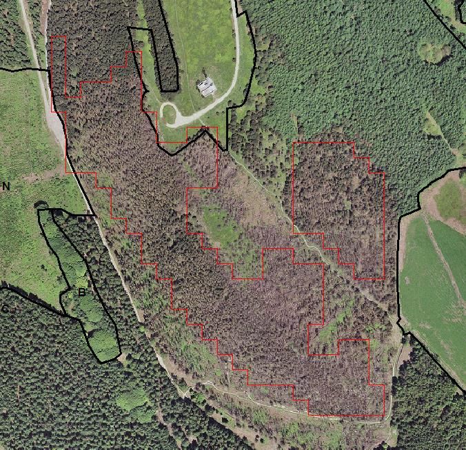
Time-series – Monitoring wind disturbances 2008-2012

 • 2615 ha of planted Sitka spruce
 • 314 ha destroyed by wind, about 12% of
 forest cover
 • FD assessment estimated 1%, as they
 only focused on larger plots

17 30 June 2016 www.forestry.gov.uk/ForestResearch
Comparison of Production Forecast using original Subcompartment Database
 and driven by revised observations and estimations from LiDAR analysis
 e.g. Cutblock in Production Forecast system
 Management Plans Forecast: Production by Compartment
 (Volume m3 overbark - thinning and felling)
 2019, 2024, 2029,
 2021, 2028, 2035 2045
 2034, 2039
 Compartment Original Revised Original Revised Original Revised
 2220 1786.46 825.44 16043.18 7827.33
 2225 1146.25 785.59 22.25 16.24 8757.71 6700.2
 2226 1614.52 1391.08 11774.48 10120.46
 2227 1967.34 1151.49 15067.87 9337.62
 2228 845.8 729.05 7054.29 6231.12
 Totals 7360.37 4882.65 22.25 16.24 58697.53 40216.73

 Original Revised
 Total area 150.07 99.15
 33% lost
 Area
 6.02 2.84
 removed
 Processed 144.04 96.31

 www.forestry.gov.uk/ForestResearch
ICESat, the only LiDAR from space…and it’s FREE!!!
 Potential of Full Waveform Satellite Lidar:
• Forest parameter retrieval 885917516_04

• Application at a regional and 60
 Raw returned waveform
 Model alternate fit

 national scale
 Signal Begin - alternate fit
 Calculated ground position
 Signal End - alternate fit
 50

 40

 Elevation (m)
 30

 20

 10

 0

 -10

 0 0.25 0.5 0.75 1 1.25 1.5
 Volts

 ICESat ice sheet elevation and cloud cover
 Source: http://icesat.gsfc.nasa.gov/

19 30 June 2016 www.forestry.gov.uk/ForestResearch
Top Height estimation

 Gaussian decomposition Waveform extent plus terrain
 method index
 •R2 = 0.73 •R2 = 0.76
 •RMSE = 4.4m •RMSE = 3.9m Source: J Rosette
20 30 June 2016 www.forestry.gov.uk/ForestResearch
ICESat, the only LiDAR from space

 Global models of
 vegetation
 condition…

 Source: Sietse Loss
21 17 Abril 2012 www.forestry.gov.uk/ForestResearch
Photon counting data proposed for ICESat-2

 Source: Phil DeCola, Sigma Space
22 30 June 2016 www.forestry.gov.uk/ForestResearch
2nd Point: we need to increase the capability
 of retrieving reliable estimates of forest
 structure

23 30 June 2016 www.forestry.gov.uk/ForestResearch
Physiological effects of water stress, e.g. Pinus nigra and sylvestris S.Spain
 (Field measurements)

 Source: Navarro et al., (Thermolidar, Unpublished)

24 30 June 2016 www.forestry.gov.uk/ForestResearch
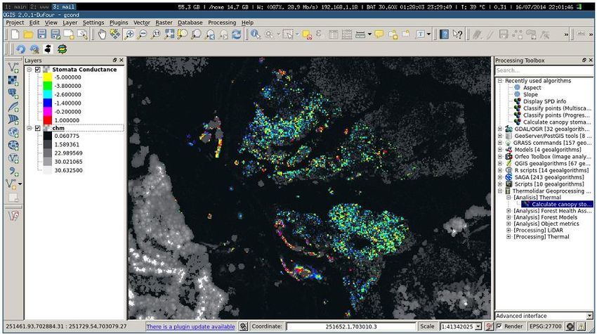
Estimated canopy conductance

25 30 June 2016 www.forestry.gov.uk/ForestResearch
DNB needle reflectance 50
 Absolute Reflectance of Healthy Tree's
 Needles TOP

 40

 Reflectance (%)
 NIR
 30
 Reflectance:
 20

 10

 0
 400 700 1000 1300 1600 1900 2200 2500
 Wavelength (nm)

 disease 60
 Absolute Reflectance of Diseased Tree's
 progress Needles TOP
 50
 Reflectance (%)

 40

 30

 20

 10

 0
 400 700 1000 1300 1600 1900 2200 2500
Source: Magdalena Smigaj Wavelength (nm)

26 www.forestry.gov.uk/ForestResearch
Pre-visual classification of stress
 Cx+c

 Ca+b

 Source: Hernández-Clemente (2012)

27 30 June 2016 www.forestry.gov.uk/ForestResearch
Training signal in Polytunnel experiments

 −
 Indices in the region ( − + − ) measuring the
 − −
 effect of inoculation

 +

 Source: William Cornforth
28 30 June 2016 www.forestry.gov.uk/ForestResearch
3rd Point: we need to increase both spatial
 and spectral resolution in order to monitor
 fundamental vegetation processes

29 30 June 2016 www.forestry.gov.uk/ForestResearch
Salford Advanced Laser Canopy Analyser (SALCA)

 SALCA system specifications:
 Pulse length 1 ns
 Pulse rate 5 kHz
 Beam width at sensor 3.6 mm
 Beam divergence 0.56 mrad
 Detector field of view 4 mrad
 Sampling rate 1 GHz
 Range resolution 15 cm
 Maximum range 105 m
 Angular sampling step 1.05 mrad

 • Dual wavelength (1040nm and 1550nm
 • Hemispherical scanning – 9.6 million waveforms
 scan

30 17 Abril 2012 www.forestry.gov.uk/ForestResearch
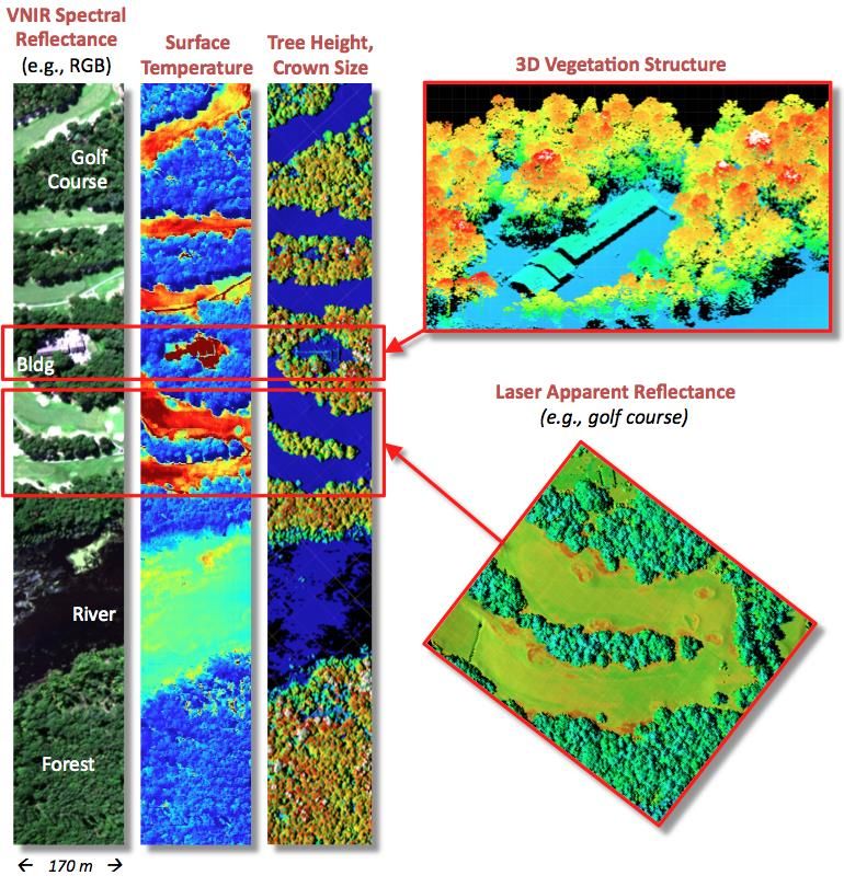
G-LiHT: Goddard’s LiDAR, Hyperspectral, and Thermal airborne imager
 Bruce Cook (PI), Jon Ranson, Jeff Masek, Betsy Middleton, Ross Nelson, Doug Morton, Larry Corp
 Science Objectives and Relevance to NASA:
 1) Instrument fusion is viewed as a prerequisite to data fusion. LiDAR, optical & thermal data for different cover types
 (NASA-GSFC IRAD demonstration)
 2) Fusion of 3D LiDAR data and 2D hyperspectral/thermal imagery provides a
 new, synergistic method for studying ecosystem structure and function.
 • LiDAR provides information on vegetation structure
 • Hyperspectral and thermal imagery provides information on ecosystem
 composition and health
 3) Data fusion can add to and enhance the science objectives of planned decadal
 survey missions, including ICESat-2 and HyspIRI.

 G-LiHT Specifications
 Scanning LiDAR (Riegl VQ-480)
 300 kHz, 1550 nm, onboard waveform processing
 Profiling LiDAR (Riegl LD-321)
 10 kHz, 905 nm, up to 3 returns per laser shot
 VNIR imaging spectrometer (Headwall)
 0.4 to 1 μm, 1.5 nm resolution
 Thermal imager (Gobi, 8 to 14 μm)
 Size (WxHxL): 30 x 30 x 60 cm
 Weight: 37 kg (G-LiHT); 10 kg (pod)
 Power: 210 W (7.5 A, 28 VDC)
 Flying altitude: 300 to 900 m AGL
 Swath: ~100 to 250 m
 Resolution: ≤1 m
 Data acquisition rate: ~50 MB/s (1 TB/d)

 Source: Bruce Cook
31 30 June 2016 www.forestry.gov.uk/ForestResearch
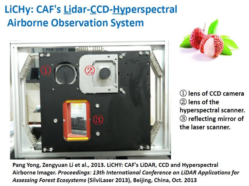
RIRI, Kunming IFRIT-CAF,
 Beijing

32 2016-06-30 www.forestry.gov.uk/ForestResearch
Sensor integration and data fusion techniques

 Source: Pang Yong
33 30 June 2016 www.forestry.gov.uk/ForestResearch
4th Point: we need integrated sensors that
 can complement each other

34 30 June 2016 www.forestry.gov.uk/ForestResearch
A wish list from the forester’s perspective

• More frequent and integrated satellite data
• Sensors capable of retrieving reliable estimates of forest structure
• Better spatial and spectral resolution
• Data fusion

35 30 June 2016 www.forestry.gov.uk/ForestResearch
Questions
 Juan C. Suárez

 normally at:
 Forest Research
 Northern Research Station
 Roslin, EH25 9SY
 UK
 juan.suarez@forestry.gsi.gov.uk

 currently until (October …):

 UMD: jcsuarez@umd.edu
 NASA: juan.suarez-minguez@nasa.gov

36 30 June 2016 www.forestry.gov.uk/ForestResearch
You can also read