Visualizzazione digitale della storia dell'Arsenale di Venezia Visualizing the history of the Arsenale of Venice - Responsabile: prof. Donatella ...
←
→
Page content transcription
If your browser does not render page correctly, please read the page content below
Visualizzazione digitale della storia dell’Arsenale di
    Venezia
    Visualizing the history of the Arsenale of Venice

    Responsabile: prof. Donatella Calabi
    Assegnista: Caterina Balletti

    Report (16 settembre 2013)

!
!

Visualizing the history of the Arsenale of Venice
Responsabile: prof. Donatella Calabi
Assegnista: Caterina Balletti

Report (16 settembre 2013)

Goals

The digital technologies are able to provide a great contribution to the processes taking place in the cultural heritage
field, lending itself to be used for different purposes: the study and research, diagnosis, restoration, protection,
management, communication-dissemination, training and use of cultural heritage.
The current information and communication technologies (ICT) provide tools to support the processes of training,
communication and information in many areas of knowledge.
Thanks to technological innovation and multimedia, in fact, it becomes possible to integrate traditional knowledge
with their approach to alternative methodologies based on e-learning and many other potential uses of ICT for
cultural and educational purposes.
In this setting the gathering of new digital technologies and history can be developed.
The main objective of the research was the identification and development of digital tools to the display of functional
growth and successive transformations of the Arsenale of Venice, its construction techniques, tested innovations and
relationships with the city.
The Arsenal, because of the complexity of urban development both in terms of time, was also included in the case
studies discussed in the largest project Visualizing Venice, an international and interdisciplinary research project
involving a large group of researchers1.
The project conceived to test the application of new information technologies to urban history with two purposes in
mind. On the one hand, it seeks to provide scholars with new knowledge and research tools that are different from
traditional means, such as primary and secondary sources. On the other, it hopes to create new forms of
communication through which historians can help non-specialists or a general public
of different backgrounds understand research on urban history.

The activities of the research have seen the use of new technologies to enhance not only the history of the urban
complex through virtual representations of its transformations over time, but also to see how it combines historical
research with the most advanced communication and dissemination strategies of digital media, through contemporary
forms of storytelling that make use of static and animated images. The research then has a real pratical relevance
with the case study as the Arsenale and a methodological value.
The virtual reconstruction of the main phases of expansion of the Arsenal can be a working tool for scholars and
practitioners as well as being used in a wider process of disclosure.
The results, described by rendering 3d models of the macroscopic (whole area) and microscopic (individual
architectures) transformations, maps from various Italian and international archives, archive photos and other
iconographic sources, it will be presented by the 'use of interactive stations in the exhibition space of the Tower of
Porta Nuova, or they will be displayed and made accessible via mobile devices.

!!!!!!!!!!!!!!!!!!!!!!!!!!!!!!!!!!!!!!!!!!!!!!!!!!!!!!!!!!!!!
1
  The group involves different skills from the University IUAV of Venice, (Prof. D. Calabi), by the University of Padova
(Prof. A. Giordano) and Duke University in Durham - NC, USA, (Prof . C. Bruzelius), with the desire to show how urban
space evolves over time. The project is educational and experimental and aims to become a rule of public awareness
may explain place and space as an ongoing process. Visualizing Venice provides a series of investigations to
demonstrate how the social and economic change have shaped the city of Venice over the centuries.
Visualizing the history of the Arsenale of Venice
                                                                                                             Caterina Balletti

!
The short story of Arsenale

The Arsenal is set up as the most typical expression of the maritime interests of the Serenissima , not only as urban
complex consisting of tezoni , warehouses and homes, but also as a place through which the Republic cured and
followed the evolution of his interests on the sea , who managed to keep for eleven centuries.
But what makes Arsenal a unique place in the world is its architecture: namely the rationality, elegance despite the
simplicity of its massive buildings, located beyond the impenetrable wall, and none of the great arsenals of the
powers of the past is come down to us in such conditions.
A particularity of the Arsenal was to have all tezoni covered by the roof, so that the production could continue also in
case of bad weather , and being able to also maintain stocks of wood sheltered from rain .
Throughout the 15th century the Arsenal place is a practical rather than decorative, slowly becomes a monumental
place to celebrate a glorious past and to pretend that it is prolonged in the present: the architecture of the Arsenale is
the architecture that celebrates the greatness and power of the Venetian state .
The primitive simplicity become, in the second half of the 16th century, decorated in stone, mouldings, fake columns
of; the more vulnerable it becomes the venetian fleet, the more refined becomes the architecture of its main military
base.
Up to 1866 the Arsenal stretched over a smaller surface , equal to m 274,000 , reaching the current sqm 318,240,
following the extended landfills that were undertaken for the construction of the three dry docks and subsequent
amendments, on the north-east , which will involve the incorporation of the island where stands the convent of the
Vergini and the area of the monastery of St. Daniel .
The current area of the Arsenal is square meters 318,240 , of which approx. 90,000 are represented by the largest
dock. These facts help to understand how is extended the manufacturing complex in relation to the whole city, which
measures a total of about 670 acres.

Research phases

The research program was divided into few main steps not unconnected with each other:
1. the collection of all the data for the analysis and study of the urban complex;
2. archiving and cataloguing iconographic data in a database;
3. management of collected data in an geographic information system as basis of rigorous reconstructions of the
history of the arsenal;
4. the representation of the story of buildings events through models that summarize the analysis and interpretation
of data;
5. the identification and definition of a method of communication through existing digital devices (movies for fixed,
mobile app).

Data collection

The first phase that contributes to the analysis of the transformations regards the collection of maps and drawings
showing the morphological evolution of the Arsenal building systems. The objective was to synthetically document
the morphological and spatial transformations of the Arsenale, representing the impact of these changes on the
current situation. The collection of these materials was necessary to make a visible and accessible documentary
heritage often difficult to use and dispersed in libraries and archives Venetian and Europe.
As can be seen from the studies of some of the city's scholar, the evolution of the physical transformations of the
Arsenale of Venice, which is closely related to the evolution of production systems, shipbuilding, allows to identify
some important moments in the historical evolution of the building core of the Arsenal specifically referable to the
end of the fifteenth and eighteenth centuries, both characterized by a process of expansion of aggregation. A third
significant period is identifiable in the late nineteenth and early twentieth century and is instead characterized by
large changes in internal demolition and further bordering expansions.

!                                                                                                                            2!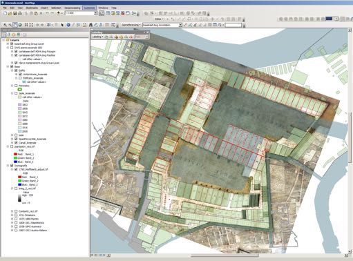
Visualizing the history of the Arsenale of Venice
Caterina Balletti
!
The city is the result of human intervention that, through long-term processes, has determined its form. The history of
the city can only be constructed by investigating these processes, through research and by studying the sources,
interpretations and their analyses. The places or events that are part of the city and its history are characterised by the
two concepts of space and time.
The collected materials, which contribute to the realization of a complete documentation of these phases, are
absolutely heterogeneous and can be briefly classified into the following types.
1> synthesis of
evolutionary
phases
1.1 Historical and current map
The historical maps is a factual basis for a diachronic analysis of the city. The purpose of the historical analysis
through the mapping is to try to understand the current structure of the territory , the result of antique choices , and
critically assess the evolutionary dynamics : the intervention exercised in the past influences the structure of the
present, as well as current interventions can influence the future.
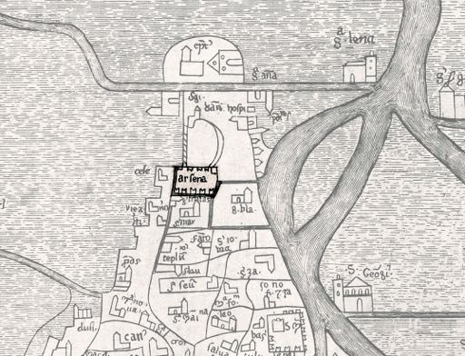
The main stages of evolution of the Arsenal are well documented by four fundamental cartographic representations :
1 - the perspective view of Venice , created in 1500 by Jacopo barbarians , which portrays the situation characterized
by the Arsenal marina and the Old New Dock . You may also notice the initial formation of the Arsenal Brand new ,
made on several occasions, with subsequent aggregation taking place within wetlands north of the New Dock .
2 - The perspective views of Gian Maria Maffioletti (1798) , preserved at the Naval Museum of Venice, which
represent the most detailed iconographic statement of the Arsenal first of the great nineteenth-century
transformations .
3 - The " General Plan of the works for the Arsenal " written by Felice Martini in 1888, which testifies to the
impressive works of transformation and modification of the physical and functions of the Arsenal : the excavation of
the islet with the demolition of building sites with the goal of joining the New dock and Newly through the creation
of the Great dock , the construction of two dry docks in the swampy area north of the Porta Nuova , demolition of
building sites in the area of Novissimetta and part of the building Squadratori for the construction of two major ports
detected; Celestia and the annexation of the area of the island of Virgin through the silting of the river of War.
! 3!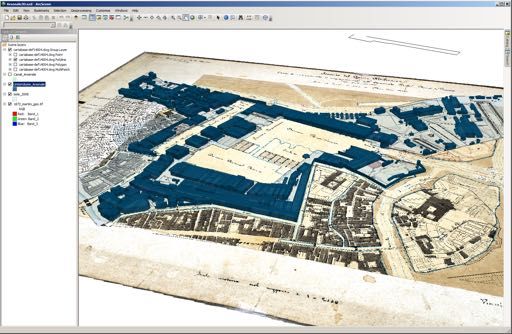
Visualizing the history of the Arsenale of Venice
                                                                                                          Caterina Balletti

!
4 - The reference to the current situation is provided by the sequence CTCN ( technical paper municipal numbers,
taken as the basis of cartographic GIS) , integrated with the most recent surveys also carried out in part by the
Laboratory of Photogrammetry of the University IUAV , and the latest air travel deals , documenting the recent work
carried out in the twentieth century : the realization of the third dry dock in the northern area of the barracks and
training .
The other maps acquired ( from the perspective views preserved at the Correr Museum in Venice photoplan 1911) , no
less important , represent intermediate stages that contribute to the narrative. Many of these have been recovered
dal'archivio digital Cartoteca IUAV University .

                                                                                                      2> some maps that
                                                                                                      represent the most
                                                                                                      significant phases
                                                                                                      of the Arsenal

To get the reproductions in digital format high resolution, were taken contacts with some institutions that preserve
the key documents that illustrate the morphological evolution of the Arsenal building systems.
In particular, contacts have been made with the following files:
Naval History Museum of Venice: digital playback of high-resolution maps of Abbot Gian Maria Maffioletti
(1798), preserved at the Naval Museum of Venice, which represent the most detailed iconographic statement of the
Arsenal first of the great nineteenth-century transformations Playback of some plates from "general plan of works for
the Arsenal" written by Felice Martini in 1888, which testifies to the impressive works of transformation and
modification of the physical and functions of the Arsenal;

!                                                                                                                         4!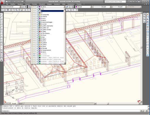
Visualizing the history of the Arsenale of Venice
                                                                                                             Caterina Balletti

!

                                                                                                      3> digital
                                                                                                      reproductions of
                                                                                                      Maffioletti plans

Correr Museum in Venice: digital reproduction of plans drawn up by Casoni, author of numerous construction
operations and extensive demolitions. There are numerous sources on the Arsenal with this body, but to complete the
descriptions contained in the Guide Casoni, priority was given to the plants that they could increase the value of
descriptive

4> digital reproductions of Casoni plans

British library: the plan of the Arsenal of Venice. (fol 47v-48r) from A voyage into
the Mediterranean Seas, containing by way of journal the views and descriptions of such remarkable lands, cities,
towns, and arsenals, their several planes and fortifications, with divers perspectives of particular buildings which came
within the compass of the said voyage: together with the description of 24 sorts of vessells of common use in

!                                                                                                                            5!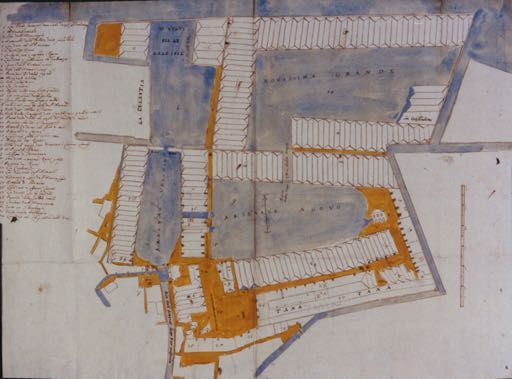
Visualizing the history of the Arsenale of Venice
                                                                                                             Caterina Balletti

!
those seas, designed in measurable parts, with an artifical shew of their bodies, not before so accurately done; finished
in the year 1685, by Edmund Dummer," [afterwards Surveyor of the Navy]

Ca Foscari, Biblioteca area Umanistica (BAUM): digital copy of plans contained in Guida all’Arsenale di
Venezia di Casoni, and in F. Martini, Progetti e lavori pel riordinamento ed ingrandimento dell'Arsenale marittimo di
Venezia. Parte 1a. - Venezia : tip. G. Antonelli, 1877. FERRARA Misc Ferrara 3504

Archivio del Genio a Roma: digital reproduction of the boards of the General Plan of the Arsenal 1873 - 1880 of
Major Happy Martini. The photographic survey was carried out on 20-21 May 2013 with the support of the photo lab
IUAV. Especially for these plans, given the obvious state of decay prevailing in the archive, playback high-resolution
digital becomes essential especially as a form of secure documentation

!                                                                                                                            6!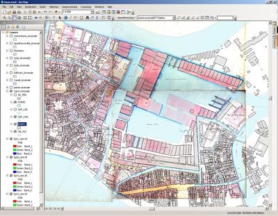
Visualizing the history of the Arsenale of Venice
                                                                                                            Caterina Balletti

!

1.2 Printed and digital surveying drawings
In recent years there have been many measurement campaigns carried out by the IUAV in the spaces of the Arsenale.
In addition, always the IUAV, has a rich digital library (raster) of the remarks made by students for courses in drawing
or Restoration.
It was necessary a long editing work of the drawings obtained also from Arsenal spa as well as the University IUAV.
The drawings, although already in digital format, geo-referenced and have been edited to make them geometrically
congruent to the data already entered in the GIS, but especially structured (identification of repetitive modules based
on the architectural style), clean and considering the 3d modeling process.

                                                                                                       5> surveying
                                                                                                       drawings
                                                                                                       (scale1:200-1:50)

!                                                                                                                           7!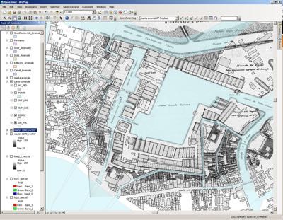
Visualizing the history of the Arsenale of Venice
                                                                                                           Caterina Balletti

!

1.3 Foto d’archivio (aeree e da terra) ;
Centro Studi Arsenale e Archivio del Genio a Roma: digital copy of some photographs (1903) documenting
the work of transforming the tense of the dock Novissima and basins.

1.4 Texts (publications, reports, studies)
The following is the basic bibliographic sources that were considered more in the reconstruction of evolutionary
phases of the complex.
•    Casoni, Giovanni, Guida per l'Arsenale di Venezia, G. Antonelli, 1839.
•    Martini, Felice, Progetti e lavori pel riordinamento ed ingrandimento dell'Arsenale marittimo di Venezia,
memoria del Maggior generale Felice Martini redatta al incarico del Ministero della Marina, Stabilimento Tipografia di
G. Antonelli, 1877

!                                                                                                                          8!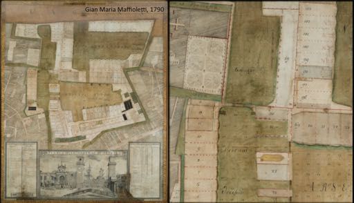
Visualizing the history of the Arsenale of Venice
                                                                                                             Caterina Balletti

!
•    Dalla Costa, Mario, L' Arsenale, bene ambientale e architettonico di Venezia - Venezia: Stampato in proprio,
1983
•    Bellavitis, Giorgio, L' Arsenale di Venezia: storia di una grande struttura urbana, Venezia, Marsilio, 1983
•    Stefinlongo, G.B. (a cura di), Arsenale, ambiente, architettura: materiali per il restauro, Padova, Centro editoriale
veneto, 1992
•    Gennaro, Paola, Le fabbriche dell'Arsenale: per una operante indagine sull'architettura degli antichi cantieri di
Venezia, Milano, CittàStudi, 1996
•    Dina, Ambra (a cura di), Venezia. La rinascita dell'Arsenale: la fabbrica che si trasforma Venezia, Venezia,
Marsilio, 2004
•    Concina, Ennio, L’Arsenale della repubblica di Venezia, Milano, Electa, 2006

2 Database

The purpose of the DB is to collate (textual and iconographic) data on urban or building transformations and to link
it, through code, to the shapes that define them. The relational DB was created in FileMaker 11 and deposited in a
server so that all researchers could store data simultaneously. Every record corresponds to an event or a source, both
of which are linked to the sites under investigation. Accompanying each of these are subforms that report archival
data, bibliographic data for what has already been published, image data for iconographic sources and the link to the
geographical data of Arsenale. This will make it possible to identity the document or event linked to the
transformation of the urban spaces and buildings

!                                                                                                                            9!
Visualizing the history of the Arsenale of Venice
Caterina Balletti
!
6> screenshot of FileMaker database
! 10!Visualizing the history of the Arsenale of Venice
Caterina Balletti
!
7> Thumbs of some of the 180 input record
3 Geographical Information System
Venice, contrary to popular belief, is not a static city, but it's changed a lot over time. This can be seen clearly when
different representations are compared.
Connecting pictures, drawings, maps, themes to large repositories of information, as it presents the cantiere of
Arsenale, allows a very deep comparative knowledge of our city, and the final choice of representations, also symbolic
(as normally happens in cartography), encoding a certain semantic value of geographic information (use of signs to
assign functions, ranks or hierarchies).
The most appropriate tool for the management of information concerning the concepts of space and time is GIS
(Geographical Information System), as it is based on temporal, spatial, quality and quantity data. It’s an environment
that has already been extensively tested and adopted in other humanities disciplines, such as in archaeology, but it is
hardly yet adopted in historical researches.
GIS are the result of digital technology for the storage, analysis, organization and communication of georeferenced
spatial data, in practice everything that is integrated with a base map or topologically related.
Whereas representing means above all knowing, the most important functions of a GIS, lie in the ability to view,
query, and as they say, "cross" the data, creating new contexts and new representations of information.
All this is made mainly according to two addresses processing: the overlap of data and spatial multifactorial
elaborations according to different informations and variables.
Knowledge through the superpositioning is derived from the simultaneous visualization of different information layers
(distinguished by themes and geometry). Knowledge through the space processing derives from the construction of
new geographic patterns starting from input data (predictive models, patterns, queries).
! 11!Visualizing the history of the Arsenale of Venice
Caterina Balletti
!
Maps, surveys, aerial photographs and descriptive data of the Arsenale have been entered and georeferenced in
ArcGIS, Esri product, which makes available a wide range of advanced GIS tools that allow you to discover patterns,
relationships and trends that characterize the geospatial data, highlighting what is often not easily derived from a
database, a spreadsheet and a statistical analysis tool. In addition to displaying data as geometric elements on a map,
ArcGIS allows their management and integration, spatial analysis, advanced modeling. Turns out to be a very efficient
tool able to manage transformations even from a chronological point of view: starting from the current state
(described by the technical map and municipal plans) the geodatabase (gdb) relating to building units has been
integrated with timing information derived from historical maps, tracing the history of the complex in a reverse order.
! 12!Visualizing the history of the Arsenale of Venice
Caterina Balletti
!
8> sccreenshot
da Arcgis dove
si legge la
sovrapposizion
e tra la
cartografia
attiuale e
quella storica
georeferenziata
! 13!Visualizing the history of the Arsenale of Venice
Caterina Balletti
!
9> screenshot
da ArcScene
con visualizzati i
diversi layer e la
tabella attributi
delle unità
edilizie
! 14!Visualizing the history of the Arsenale of Venice
Caterina Balletti
!
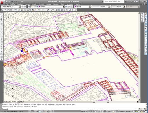
4 . representation of the story of buildings events through models
In our society, in which the visual communication has assumed a key role in the dissemination of information, the 3D
model, suitably adapted to technological possibilities of our times, can be easily seen as a extremely incisive way of
communicating the information related to the territory and the city.
It was built a model for each of the 10 phases of expansion of the Arsenal starting from the base map provided by the
GIS (geo-referenced historical maps +CTC) at the time analyzed. The volumes of the architectures were built crossing
the current cartographic data, with surveyng dawings, with maps and the iconography collected. The chosen
representation scale (1:200) has a level of detail, and of complexity, sufficiently accurate to characterize each building
through cornices, stones, windows, doors, types of roofs.
The models were created in Autocad environment, starting with the today description, carefully documented by the
most recent surveying works. For each architecture has been identified the original structure and any additions or
changes that have characterized the transformations. In this way it was possible to reconstruct back the history of the
building, in a sort of reverse engineering of the architecture.
10> screenshot in Autocad of the
georeferred model
! 15!Visualizing the history of the Arsenale of Venice
Caterina Balletti
!
11> rendering of the current state model (3dStudio Max)
! 16!Visualizing the history of the Arsenale of Venice
Caterina Balletti
!
12> rendering
! 17!Visualizing the history of the Arsenale of Venice
Caterina Balletti
!
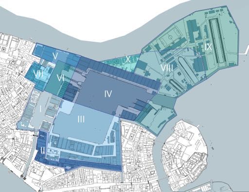
The modeled phases are:
Phase X: represents the latest state, based on the current maps and on the most recent surveying works, with the
presence of Casermette’s area.
Phase IX: Implementation of the large dry dock, the Prince of Piemonte (1910). The reference cartography is the
photoplan of Venice dated 1911 and the Catasto Austro-italiano.
Phase VIII: construction of dry docks with the consequent diversion of the canal Biria. The last 3 tesoni of Isolotto can
be still seen on the current Square of the Empire, the north tesoni face directly onto the dock. Aggregation of the Isola
delle Vergini. The reference mapping is the plan drawn up by Martini, in 1881, as a record of the progress of the
reorganization of the Arsenale.
Phase VII: annexation of the whole of Celestia (1810). The Tower of Porta Nuova, before the last of the four tezoni
low to Loreto, was built, designed by Engineer Lessan. Opening the gate of Porta Nuova. Map reference: Casoni and
Maffioletti.
Phase VI: development of the dock of Galeazze (1569). Reference map: the plan of Dummer and a Anonymous one
conserved by Archivio di Stato di Venezia.
Phase V: aggregation of the enclosure of dust, located at the northwestern tip of the Arsenale Novissimo, for the
activities of processing and storage of gunpowder. The area is then connected with the Arsenale Vecchio after the
purchase of additional land from the convent of Celestia (1564).
Phase IV: the Arsenale Novissimo is made on several times until 1573 due to successive aggregations of north
wetlands of the Darsena Nuova and the creation of a third dock called Novissima.
Phase III: the third extension. Arsenale Nuovo formation after the purchase of some wetlands and the lake of San
Daniele, located to the east of the Arsenale Vecchio. The modelled space refers to the view of the de Barbari, to
indicate the beginning of the work which will be completed in Phase IV.
Phase II: second extension. Aggregation of land to the east of the fortified perimeter.
Building the fourteenth-century shipyards and the walls. Building workshops for the manufacture of oars, deposits of
tar, cables, rigging, wood, nails, anchors and chains in the southern belt of the Darsena Nuova, called Campagna,
connecting with the Arsenale chanal.
Phase I: the core. The first document that testifies to the existence of the Arsenale Vecchio consisting of two rows of
covered shipyards, aligned around a dock and connected to the basin of San Marco through the chanal of the
Arsenale, all surrounded by crenellated walls, is represented in the map of the fourteenth century Chronology Magna.
! 18!Visualizing the history of the Arsenale of Venice
Caterina Balletti
!
Phase 10
Phase 9
The first photoplan of Venezia, 1911
! 19!Visualizing the history of the Arsenale of Venice
Caterina Balletti
!
Phase 8
Phase 7
Casoni, Piano dell’arsenale di Venezia, 1829
[Museo Correr}
! 20!Visualizing the history of the Arsenale of Venice
Caterina Balletti
!
Phase 6
Anonimo, Pianta dell’arsenale, XVII
Phase 5
! 21!Visualizing the history of the Arsenale of Venice
Caterina Balletti
!
Phase 4
Phase 3
Jacopo de Barbari, Veduta, 1500
! 22!Visualizing the history of the Arsenale of Venice
Caterina Balletti
!
Phase 2
Phase 1
Fra Paolino, Chronologia Magna, xiii secolo,
ridisegnata ed incisa su rame dall'architetto
Tommaso Temanza nel 1781
! 23!Visualizing the history of the Arsenale of Venice
Caterina Balletti
!
Details of phase 10
Details of phase VIII
! 24!Visualizing the history of the Arsenale of Venice
Caterina Balletti
!
Details of phase VII
Details of phase III
! 25!Visualizing the history of the Arsenale of Venice
Caterina Balletti
!
5 Comunication
The new technologies lend themselves to give their contribution to the process of study and research, communication
- dissemination , training, and utilization.
In the case the research carried out , ICT is able to provide the necessary applications to integrate into a coherent
whole information on the Arsenale arising from different sources, often not communicating with each other.
The role of digital tools is then extremely innovative in the processes of communication - dissemination, training and
more extensive use in the field of cultural heritage ; these processes are intricately intertwined with respect to which
new technologies can make a contribution cross .
In the field of communication and dissemination and use the offered possibilities are mainly related to the following
areas :
1 . virtual reconstructions: assuming that different media are in fact the organization of a view of the collected and
stored data in the database, it comes to applications, especially in 3D graphics which allow to virtually reconstruct the
original terms of cities , architecture, works of art , to navigate virtually no longer visible places , such as the Arsenale .
In architecture , the term model also has a meaning that distinguishes it material to the construction technology
together , the level of detail and its genesis .
Models and maquettes undoubtedly attract a high level of skill. Wood or plaster that constitute them determine not
only the form but also the possibilities of expression and communication . The wooden model , perfect in their
assembly and in their details , have the effect of crystallizing the thought and anticipate reality. In the past , they
helped the architect to foresee for himself and for the client , the building even before its completion .
While traditionally the maquette is intended to communicate the design to satisfy the desire to "see ahead ", in the
case of the Arsenale, the models produced are meant to "see the past." Also in the maritime tradition, there are many
wooden models of fortresses or ports .
Precisely those factors have led to the rendering of the models "in the manner of" wooden models preserved at the
Naval History Museum.
The renderings were made using Felix Render, a rendering professional system that integrates the system as the
rendering engine Maxwell Render.
2. Interactive multimedia applications: multimedia products aimed at promoting knowledge of art intended for the
general public (adults, students, etc..) Consist of the collection of images produced (rendering, historical maps, texts,
iconographic reproductions of) structured in an interactive presentation. This type of application is to be considered as
part of the virtual museum which will take place in the Tower.
3. Web: The Internet is the main tool to disseminate, communicate and promote our heritage. Consider that the most
recent statistical report asserts that the time spent surfing the Internet has surpassed that of staying in front of the
television! The resources on the network in fact are immediately accessible from all over the world and have no
distribution costs. Internet currently is in essence a "virtual museum" potentially visited by all users of the world, The
research on the Arsenal could easily be published on the web directly, directly from the portal Arsenal spa, Project
Second Chance or university.
4. Applications for handheld and mobile devices: it is the new frontier in the field of integration of art and technology.
These applications are in fact able to integrate into single device cognitive resources that are usually available
separately (information derived from Web sites, audio guides and brochures distributed in museums, educational
games, chat, online shopping, etc.).
Just in this area has been developed an app that uses maps of Venice and in particular those of the Arsenale. The
"historical maps on mobile devices" stems from the possibility offered by modern mobile devices (smatphone, iphone,
tablet) of geolocalize via the internal GPS receiver, the position of the device and then provide different kinds of
information about the location identified . Many software applications can use this potential to offer geolocation
capabilities using base maps that show the area representing their geographical aspects, geomorphological,
infrastructure, etc.., Related, generally, to the current situation. General objective of the work is to study a method to
determine in real time on a historical map the positions corresponding to geographical locations from GPS systems.
The application, that will be next presented in the International Workshp Digital Approaches to Cartographic Heritage
in Roma can then be implemented with the contents of the rendering to get an application of augmented reality.
! 26!Visualizing the history of the Arsenale of Venice
Caterina Balletti
!
Congress, seminars and exhibitions
The project was presented in:
International Conference
Second Chance From Industrial Use to Creative Impulse
Venezia, 25 ottobre 2012
8th International Workshop
Digital Approaches to Cartographic Heritage
Roma, 19-20 september 2013
Exhibitions
Visualizing Venice new technologies for urban history
> 5-21 dicembre 2012
Cotonificio veneziano, Università Iuav di Venezia
spazio espositivo Gino Valle
> 1-22 marzo 2013
Istituto Italiano di Cultura
Zagabria
> 8-26 aprile 2013
Ufficio Regionale dell’UNESCO per la Scienza e la Cultura in Europa
Palazzo Zorzi
Venezia
! 27!Visualizing the history of the Arsenale of Venice
Caterina Balletti
!
> aprile 2013
Duke University
Durham (US)
>13 giugno – 12 luglio 2013
Spazio Espositivo Santa Verdiana, Università degli Studi di Firenze
Piazza Ghiberti, 27
Firenze
>13 settembre- 12 ottobre 2013
Palazzo Ducale
Zara
Teaching seminar
La storia dell’Arsenale
Corso di Composizione architettonica, corso claMarch, prof. S. Rocchetto
Papers
>Giornale Iuav 123
>Calabi D.(a cura di), Built city, designed city, virtual city. The museum of the city, Croma, Roma, 2013
In corso di pubblicazione
>Balletti C., Fuerra F., Mazzanti M., Walking through historical maps of Venice, e_perimetron (The international
quarterly e-journal on sciences and technologies affined to history of cartography and maps)
! 28!Visualizing the history of the Arsenale of Venice
Caterina Balletti
!
6>Contributo
contenuto nel
Giornale Iuav
dedicato alla
mostra
! 29!You can also read