Walking and cycling in our region - NZTA
←
→
Page content transcription
If your browser does not render page correctly, please read the page content below
Wellington to Hutt Valley Walking and Cycling Link

Walking and cycling
in our region

More people than ever are exploring
the Wellington Region on foot or
by bike, e-bike or scooter. The NZ
Transport Agency and the region’s
councils are developing new facilities
around the region to support them
and encourage more people to take up
biking and walking. These projects aim
to improve connections, safety and the
overall experience for people as they
move around the region.
In Wellington the NZ Transport Agency is supporting
Wellington City Council’s projects to create new routes                                                  TE WHANGANUI A TARA
in the CBD and eastern and southern suburbs.. In Lower
Hutt, we have collaborated with Hutt City Council on
the Wainuiomata Hill shared path and the Eastern Bays
shared path.
Together with both city councils and Greater Wellington
Regional Council we are now working on the largest
single walking and cycling project in the region, the
Wellington to Hutt Valley (W2HV) link, connecting
Wellington and Lower Hutt.
The Ngauranga to Petone section of the W2HV link is
critical, as it will fix a missing link in the walking and
cycling network, making it safer and easier to get around
the region by bike or on foot.
                                                                   THE GREAT HARBOUR WAY / TE ARANUI O PŌNEKE
                                                                   The Ngauranga to Petone path will form a vital section of Wellington’s Great Harbour
  WHAT YOU CAN EXPECT                                              Way/Te Aranui o Pōneke – a continuous 72-kilometre route for walkers and cyclists
  FROM THIS EVENT:                                                 around the perimeter of Te Whanganui a Tara, from Ōrua-pouanui/Baring Head in
                                                                   the east, to Te Rimurapa/Sinclair Head in the west. It will be a spectacular way to
  Thank you for coming to find out more about the Ngauranga to     experience and connect with the beauty of Te Whanganui a Tara, the region’s vibrant
  Petone section of the Wellington to Hutt Valley walking and      communities, its cultural heritage, and its stunning coastline and wildlife including
  cycling link. At today’s event, you can learn more about the     lizards, seals, dolphins, penguins and seabirds.
  proposed path and its features. We’ve included information
  about the design, including illustrations to show how we think   The completed Great Harbour Way/Te Aranui o Pōneke will offer a unique
  the path will look once it is completed.                         opportunity to walk, run or cycle the entire coastline of a major city harbour, accessing
                                                                   communities, beaches, forest, parks, marae, marinas, cafes, theatres and shopping
  The design has not yet been finalised, but you can see what we   along the way. This flat, safe and continuous route along the water’s edge will be
  have done so far. Some aspects are subject to change and you     possible to walk in 3-5 days, and to cycle in 1-2. The route is also connected by
  can see features we have thought about to help create a high-    ferries, buses and trains so sections can easily be accessed.
  quality walking and cycling link that honours the harbour and
  our natural environment.
  You can also find more information and share your
  feedback at www.nzta.govt.nz/w2hvlink
Wellington to Hutt Valley Walking and Cycling Link
Project overview
Melling Railway Station
5 Lower Hutt
N
2
Petone Railway Station
Johnsonville Petone
Wellington to Hutt Valley
Walking and Cycling Link 3
Petone to Melling Section
Ngauranga to Petone Section
Wellington CBD to Ngauranga
Wellington CBD to Ngauranga
Section – opened 2018 Ngauranga Gorge TE WHANGANUI A TARA
Wellington CBD to Ngauranga
Thorndon Quay cycling
Planned Thorndon Quay
Mātiu / Somes Island
Cycling Improvements Ngauranga Interchange
Khandallah
4
Wellington to Hutt Valley
Walking and Cycling Link
Ngaio Gorge
Connections
1. Wellington City Network
Completed section
2. Belmont Park Trails
Opened 2018
3. Petone Esplanade
1
The Wellington to Hutt Valley Walking and Cycling link
4. Eastern Bays is made up of three sections:
Planned Thorndon Quay
cycling improvements WELLINGTON CBD TO NGAURANGA
(Let’s Get Wellington Moving)
Parts of this, including parts of the Hutt Road walking and biking paths, have been completed
and are now open for the public to use.
Wellington Railway Station
NGAURANGA TO PETONE
Learn more about this section, and provide your feedback, at today’s drop-in event.
Eastbourne
PETONE TO MELLING
Wellington
This section has received resource consents, meaning it is almost ready to move to construction.
THE KEY BENEFITS INCLUDE:
This project is more than a path for walking and cycling. It is to create a place
• A safer and more attractive walking and cycling
that connects us. A place for whanau to gather. A place for people to fish and for route between the Hutt Valley and Wellington
families to explore. A place to provide habitat for wildlife. And a place that brings • More people choosing to walk and cycle,
us closer to our natural environment. It is a project to return the coastline of supporting better health and reducing vehicle
Te Whanganui a Tara to the people. emissions and congestion
• Improved resilience from a new rock seawall that
will provide greater protection from the effects of
sea level rise and storm surges. The path will also
be able to act as a recovery route.
A cycling route from Ngauranga to Petone has been • New recreation and tourism opportunities that
could benefit local communities
proposed since as early as 1901. In 2012 we began and businesses
to investigate options for a new Wellington to Hutt WE WANT YOUR FEEDBACK
Valley walking and cycling link, which led to the We want to know what you think about our proposed
design for the sea-side shared path. You can let us know
development of this project. your thoughts using Social Pinpoint, our online map-based
feedback platform, or by filling in a feedback form. You can
also email us, or simply tell one of our team members.
In 2013 and 2014 we asked for community feedback on two options – a sea-side option and a road-
Your comments will help us to get the design to the point
side option for the Ngauranga to Petone section. In 2015 we selected the sea-side option, which was
where it is ready to go forward for resource consents. The
chosen by 68% of people. It will deliver a safe, attractive, separated route with additional resilience project team will consider the feedback along with advice
benefits for SH2 and the rail corridor. from technical experts. Before we apply for resource
consents, we’ll report back, letting you know how your
It will connect with the Wellington CBD to Ngauranga section at its southern end, and the Petone to
feedback helped shape the project.
Melling section to the north, creating a new, consistent route between central Lower Hutt and Wellington.
Social Pinpoint: nzta.mysocialpinpoint.com/w2hvlink
Email us: w2hvlink@nzta.govt.nz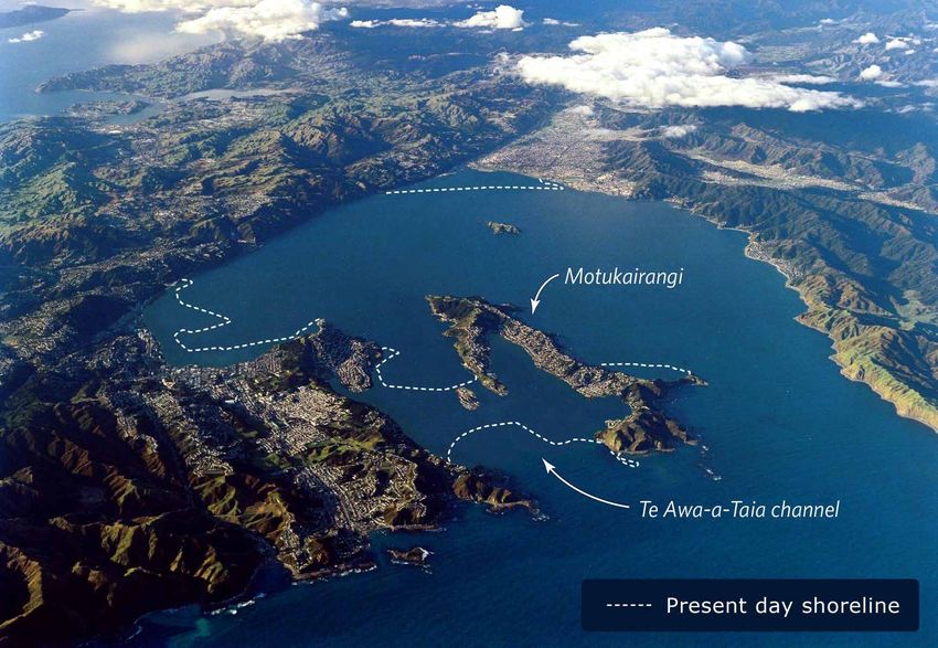
Wellington to Hutt Valley Walking and Cycling Link

Providing an exciting
coastal experience

                                                                                        OUR URBAN
                                                                                        DESIGN THEME
                                                                                        The urban design theme that we
                                                                                        are proposing is a concept for a
                                                                                        bold, connected and shared path
                                                                                        at the harbour’s edge.
                                                                                        Bold – As part of a world class
                                                                                        waterfront with a look and feel
                                                                                        that fits well within the existing
                                                                                        environment.
                                                                                        Connected – To our cities, to
                                                                                        other cycle and public transport
                                                                                        networks, to the coastal edge, and
                                                                                        to our cultural history and heritage.
We have one of the world’s most beautiful                                               Shared – A path providing for
                                                                                        walking and cycling with a design
harbours, but a large section of the coastline                                          that celebrates mana whenua
                                                                                        values and the importance of the
of Wellington Harbour/Te Whanganui a Tara                                               harbour and coastline to our cities.
                                                                                        This theme will guide our thinking
is currently inaccessible. For cyclists and                                             as we develop the concept design.
                                                                                        It will apply as we consider specific
pedestrians travelling between Ngauranga                                                features such as lighting, fencing,
                                                                                        seating and ongoing maintenance

and Petone, there are few options, and the
                                                                                        requirements. We will also
                                                                                        consider the urban design theme
                                                                                        when we look at construction
options that do exist don’t always make for                                             methods that can limit effects on
                                                                                        the environment.
a pleasant experience.
Parliamentary records show that a separated footpath and cycleway along this route
has been called for since 1901, but it has never eventuated.
We want to change that. In 2014 we asked the community to choose between two
options for a safe, separated walking and cycling path from Ngauranga to Petone.
The options were:
• A roadside option, extending the existing path alongside SH2 to provide a 3m-wide
  dedicated path.
• A coastal option, reclaiming the foreshore at the harbour’s edge to create a
  dedicated path on the seaward side of the rail corridor.
The feedback we received showed an overwhelming preference for the coastal option,
with people saying it would be safer and more pleasant than the roadside option.                                                Indicative artist’s impression
We also heard that it was important to create a connection between land and sea
– one that would provide people with an opportunity to experience a part of our
harbour that has been off-limits for decades.
                                                                                        WHAT IS GUIDING OUR VISION?
                                                                                        • Placemaking and respect                • Recreational and
People told us a coastal path has the potential to boost tourism, recreation and          for the harbour                          tourism benefits
health. And our key partners told us it has the potential to help make the region’s
                                                                                        • Fixing a missing link                  • Creating a safe and
transport network more resilient at the same time.                                                                                 well-used path
                                                                                        • Improving resilience
We have heard your feedback, and have designed a route that not only provides                                                    • Encouraging more people
                                                                                        • Access to the coastal environment
space for walking and cycling, but access to our world-class harbour.                                                              to walk and cycle
                                                                                        • Quality of life and health benefits
This will be more than a path for walking and cycling. It is an opportunity to unlock
the coastline to the public, to reconnect communities, and to provide a coastal
experience like no other.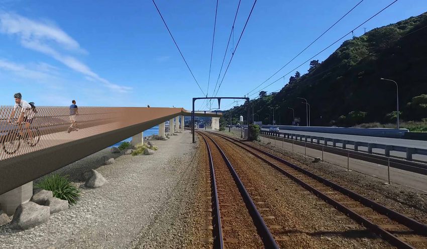
Wellington to Hutt Valley Walking and Cycling Link

History of the harbour
– Te Whanganui a Tara
The history of Wellington Harbour/Te Whanganui
a Tara is one of change. From the days when waka
were launched into the waters of the harbour,
to today, where regular trains traverse the route,
the coast has always provided a means of access
and connection.
The coastline from Ngauranga to Pito One was, and is, framed by the steep coastal
escarpment which falls into the harbour, with little space to walk around the
margins, even in Māori times.
Te Ātiawa – Taranaki whānui, more than any other iwi who lived around the
harbour, established Pā and Kainga in this area. Ngauranga Pā at the mouth of
the Waitohi Stream was established by Te Ātiawa hapū, with many having moved
from Koangaumu in Titahi Bay. The paramount Chief Te Wharepouri (Kakapi o te
Rangi) moved there and established a base, where they used waka as their main
form of transport.
Other parts of the hapū of Ngati Tawhirikura and Ngati Te Whiti also moved                                       GNS Science, Lloyd Homer, VML4383 and Te Ara
to Pito One at the western end of what was to become Petone Beach near
the rich Korokoro Stream, following the establishment of Ngāti Mutunga.             A CHANGING ENVIRONMENT
The chief Honiana Te Puni Kokopu made his home there and for a time housed
the New Zealand Company’s principal agent, William Wakefield.                       In the 15th century a major earthquake known as Haowhenua struck,
                                                                                    causing huge change to the landscape of what we now call Wellington
The places in between the main Pā featured sea caves used for hidden burials        Harbour. Before this earthquake, the Miramar Peninsula was an island called
(Te Ana Puta) and linked to the point called Pari Karangaranga, where the           Motukairangi, separated by a shallow channel called Te Awa a Taia.
echoes off the cliffs were thought to be from the spirits of the dead. This
was a coastline heavy with mana wairua.                                             Land along the Ngauranga to Petone section was reclaimed after the 1855
                                                                                    earthquake to construct the existing railway lines. The existing seawall has
The streams flowing into the harbour helped generate a rich fishing resource that   both sloping sections built from compacted fill with rock armour and vertical
included most common sea fish, but also varieties of whales and sharks. The reef    concrete sections. Over time this has become eroded needing additional
system along the coastline supported some shellfish, however other areas of the     works. Major storms have previously undermined the rail line as it is located
harbour were more abundant in kutai (mussels), pipi, tuatua, and tio (oysters).     very close to the edge. This last happened in 2013, disrupting rail services
The coastline and its settlements were closely connected with Mātiu, Mākaro         while repairs were undertaken.
and Mokopuna islands. For Māori, Te Whanganui a Tara was the link between           The coastline between Ngauranga and Petone is heavily modified. Since
communities and a mahingakai for fishing and sea resources. It was, and probably    the first road was completed in 1841, it has been constantly built upon and
still is, the heart of the whole tribal community. – Morrie Love                    reclaimed to provide for additions to the road and rail corridor. A small seawall
                                                                                    provides some protection from the elements, but this is very narrow in places.
                                                                                    While there are some natural rocky outcrops along the coastline, much of the
                                                                                    route is made up of rock armour and concrete reinforcement.

                                                                                    THE NEW ZEALAND COASTAL POLICY STATEMENT
                                                                                    Construction of the proposed walking and cycling link will require work
                                                                                    in the Coastal Marine Area, including reclamation to create new land.
                                                                                    The New Zealand Coastal Policy Statement (NZCPS) directs how activities
                                                                                    should be managed in the Coastal Marine Area.
                                                                                    The NZCPS states that reclamation should be avoided unless there is a clear
                                                                                    need for it, there are no practicable alternatives, and it will provide significant
                                                                                    regional or national benefit. Other policies that are directly relevant to the
                                                                                    proposed cycleway are those relating to protection of indigenous biodiversity
                                                                                    and preservation and restoration of natural character.
                                                                                    Further development of the proposed design must carefully consider the
                                                                                    NZCPS policies. Amongst other things, particular matters to be considered
                                                                                    include public access, climate change and sea level rise, the shape of the
                                                                                    reclamation, the design and materials used, the impact on water quality and
                                                                                    biodiversity, the ability to remedy or mitigate adverse effects, and the effects
    NGĀ ŪRANGA ME PITO ONE                                                          on values and sites of significance to mana whenua. These matters will be
    The name Ngauranga is derived from Ngā Ūranga,                                  specifically addressed by the Transport Agency over the next few months as
    the landing place of waka.                                                      the design is developed.
    The name Petone is derived from Pito One,
    the end of the sandy beach.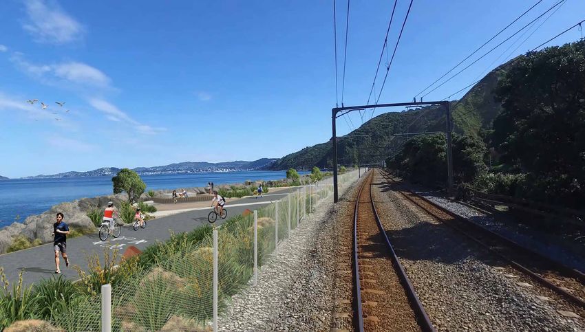
Wellington to Hutt Valley Walking and Cycling Link
Korokoro Stream
Petone
Designing a path
fit for our harbour
Honiana Te Puni
Reserve Connection to
The Esplanade
and Petone
KOROKORO (Name TBC) Station
Gathering space
with seating and
Horokiwi Quarry
coastal planting
Existing
reclamation
Gathering space with
We want this to be a walking i Rd
seating and cycle
racks. Ngaio trees for
shade
and cycling path that the
kiw
Ho
ro
HOROKIWI (Name TBC) Opportunity for
Waihinahina Stream
storytelling in design
community can be proud of,
and signage
Coastal planting for
with a design that complements
birds and skinks
our stunning harbour. TE ANA BAY (Name TBC)
Typical shared path
Pari Karangaranga
Based on community feedback, we selected the (Cliff of Echoes)
sea-side option and began work to design a shared
Te Ana puta
path at the harbour’s edge. The design presented
here reflects input from project team specialists,
key stakeholders
Newlands
and the wider community.
ir
sC
es
Dr
Coastal planting
This project is an opportunity to create something
Cromwell Point
to sea side of
path for birds
more than just a route for commuters. It will open KARANGA POINT (Name TBC) and skinks
up a part of the harbour that has been inaccessible
for many years, so we want it to be a coastal path
of the highest standard.
Coastal planting
We are investigating how to minimise effects on for birds and
skinks
the environment, how to use best practice Paroro-rangi
and kainga PARORO BAY (Name TBC)
New separated
cost-efficient construction methods, and to make bird habitat
sure that the path is safe and easy to maintain.
The shared path will also connect to the Petone Gla
Gathering space with
railway station and the Hutt River / Te Awa Kairangi nm
ire
Rd
seating and cycle racks
and Ngaio trees for shade
Start/finish Waka Ama races
via the Petone to Melling section, which is due to PARORO-RANGI POINT (Name TBC) Opportunity for storytelling
start construction this year. in design and signage
Coastal planting for birds
We think this is an exciting, bold, and transformational and skinks
project. Our design has to honour the harbour New separated bird habitat
on which it sits, and provide the public with
D u n garvan
Rd
KAINGA STREAM (Name TBC)
Coastal planting
to sea side of
a space that they can be proud of. path for birds
and skinks KEY FEATURES
New separated
bird habitat • A 5m wide path at the
harbour’s edge
Gathering space with
seating and cycle • A walking and cycling bridge
racks. Ngaio trees
for shade
to link the southern end of
TAHATAHA ROA (Name TBC) the path to Hutt Road, and
Opportunity for
storytelling in design onward to Wellington City.
and signage
Coastal planting
• Connections at the northern
for birds and skinks end of the path to the Petone
Esplanade and to the Petone
Gathering space with
seating and cycle racks.
to Melling cycleway.
Ngaio trees for shade
• Additional gathering spaces
2 PIKI WAHINE POINT (Name TBC) Opportunity for
along the route, coastal
storytelling in design
and signage
planting, bird habitat and
Coastal planting for
birds and skinks
points for people to access the
Existing reclamation
water. We have called these
“landings” or “ūranga” – this is
Gently sloped ramps explained on the next board.
TE WHAREPOURI BRIDGE (Name TBC) with landings.
Off-line viewing area looking
towards Matiu/Somes Island
Story of Te Wharepouri Key
Ngauranga Gorge (TBC with mana whenua) Bottom of rock seawall
told through bridge design Top of rock seawall
and signage 5m Shared Path
Proposed overbridge
Ūranga – Landings
High Tide Bench Landing
We’ve identified potential names for the ūranga along the path that reflect and honour High Tide Separated Habitat
the names of places on the harbour shoreline and escarpment. Typical Landing
Typical Path
The name Te Wharepouri remembers an ancestor and Paramount Chief of Te Ātiawa who Coastal Planting
was known for his command of waka. Te Wharepouri was originally named Te Kakapi o Te Gathering Areas
Rangi and was named Te Wharepouri by Ngā Puhi. He was a fighting chief, having come
through many battles in Taranaki where he was born. Te Wharepouri
pointed out the boundaries of the Te Ātiawa-Taranaki Whānui to
Ngauranga Station
Wakefield and the New Zealand Company in 1839.
These names are all just ideas for now. We are working
1 in partnership with Taranaki Whānui to name these
places and the path in a way that tells the history
of this place.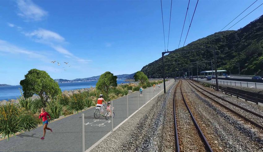
Wellington to Hutt Valley Walking and Cycling Link
Creating and
protecting new land
As we have worked on the design for
the path, and the coastal reclamation ŪRANGA / LANDINGS
that it will need, we have considered The name Ngauranga derives from Ngā Ūranga – the landing place.
We have chosen this name, ūranga or landing, to describe the
and included features that support additional spaces included in our design, beside the pathway.
people, flora and fauna. They will become gathering places for people, and habitats suitable
for the birds of the harbour.
We aim to create a new rock seawall that delivers benefits for the environment, These are important features of the project – on this poster we show
for wildlife, for users of the path and for the resilience of the infrastructure cross sections of these. On the next poster, you will see how they
corridor. It will also be future-proofed to cope with the effects of sea level rise. might look and feel in our artist’s impressions. The standard, or
typical, path is also shown for comparison.
Along the path we have designed a number of “landings” or “ūranga” Board 6
– places where the seawall is varied to create extra space for people to
enjoy the scenery, go down to the water’s edge or rest on their journeys, Typical Shared Path
and places for birds, sea life and plants to inhabit. 1.8m mesh fence 5m shared Bench future proofed
with integrated path for sea level rise
lighting
Access at low tide
for recreation
PROTECTION FROM THE SEA MHWS
MSL
MLWS
In 2013 a major storm washed out part of the rail corridor. This caused days
of disruption and flow-on effects, as rail commuters were forced to use the
road instead, increasing the strain on the roading system.
With the frequency of violent storms increasing, and sea levels rising,
Typical Landing
we need to make sure a new seawall can stand up to the worst of • Karanga Point
• Te Ana Bay
Wellington’s conditions. Coastal planting with
Ngaio trees for birds
Our new walking and cycling path will include a new rock seawall and five- 1.8m mesh fence
with integrated
5m shared
path
and skinks Bench future proofed
for sea level rise
metre-wide reclamation, offering improved protection to the road and rail lighting
from storm surges, and reducing the risk of washouts. It will also be designed
to help protect pedestrians and cyclists from sea spray in most conditions.
MHWS
MSL
MLWS
High Tide Bench Landing
• Tahataha Roa
• Paroro-Rangi Point
• Horokiwi
Coastal planting Lighting bollards Gathering space with
with Ngaio trees in seating and cycle
some areas racks. Ngaio trees for
5m shared shade and coastal
path planting Access for recreation/
1.8m mesh fence fishing
MHWS
MSL
MLWS
High Tide Separated Habitat
• Kainga Stream
• Paroro-Rangi Point
• Paroro Bay
Coastal planting with
Ngaio trees for birds
and skinks Separated bird
1.8m mesh fence 5m shared habitat
with integrated path
lighting High tide channel
to separate bird
habitat
MHWS
MSL
MLWS
MHWS - Mean High Water Springs
MSL - Mean Sea Level
MLWS - Mean Low Water Springs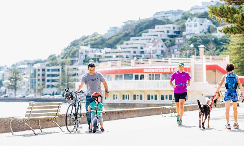
Wellington to Hutt Valley Walking and Cycling Link

A safe, attractive, and
accessible coastal experience
These images show some points along the route

                                           Indicative artist’s impression                                            Indicative artist’s impression

KOROKORO name tbc                                                             KARANGA POINT name tbc
The path begins here connecting to The Esplanade, the Petone to Melling       The Karanga Point landing is an example of space in our design for
cycling path and the Petone Foreshore. It passes the Wellington Water Ski     coastal planting. We will select appropriate species to plant that will
Club’s clubhouse on Honiana Te Puni Reserve and the Wellington Rowing         support potential habitat for native birds and skinks, between the rock
Club’s boat shed ‘the Green Shed’.                                            seawall and the edge of the path.

                                           Indicative artist’s impression                                            Indicative artist’s impression

TE ANA BAY name tbc                                                           TAHATAHA ROA name tbc
This view shows a typical or standard section of the path at Te Ana Bay,      Toward the Ngauranga end of the path, there will be another rest and
the bay beyond Horokiwi. This view shows how runners, walkers, cyclists       viewing area, with a rock bench to allow people to access the water’s
and even skateboarders would share a safe, separated path between our         edge – this is intended to create opportunities for fishing and other
proposed landings. A low fence will mark the boundary of the rail corridor,   recreational activities.
while maintaining views of the harbour for train passengers. The rocky
seawall will be designed to minimise spray and will be raised slightly
higher than the path to keep users safe.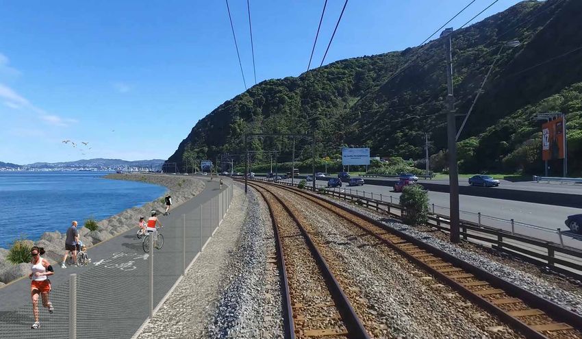
Wellington to Hutt Valley Walking and Cycling Link

   An iconic bridge
   design for Ngauranga
                                                                                                       Mātiu/Somes Island

                                                                                                                                                  Indicative artist’s impression

   Our design includes a new walking and cycling
   bridge which crosses the railway line, linking people
   to the harbour-side path. It will be part of a sequence
   of structures and other elements designed around
   the central concept of a bold, connected and shared
   path at the harbour’s edge.
   An underpass was considered as an option early on, but it was discounted because it would be
   difficult and costly to construct so close to the sea and it would not provide for an enhanced
   coastal experience for cyclists and pedestrians.
   The bridge near the Ngauranga interchange will provide a smooth connection for commuter
   cyclists as well as being accessible for walking. The ramps will have an easy gradient with
   balustrades, handrails and lighting integrated into the main structure to avoid handle bar snags.
   We are considering a concept with design features that help tell the story of Ngauranga and a
                                                                                                                            Taumanu Reserve Bridge, Onehunga, Auckland
   wider section of the bridge to provide a generous layby or rest area with seating for views of
   the city and harbour without interrupting the main flow. The underside of the bridge will also
   be designed to be viewed from the rail and road – contributing to the quality of the waterfront              BEST PRACTICE
   experience for motorists and train passengers.                                                               DESIGN
                                                                                                                The NZ Transport Agency’s
                                                                                                                urban design guide, Bridging
                                                                                                                the Gap, provides detailed
                                                                                                                recommendations for walking
                                                                                                                and cycling bridges which are
                                                                                                                based on best practice, both
                                                                                                                here and overseas.
                                                                                                                Our architecture and engineering
                                                                                                                specialists use these guidelines and KiwiRail’s
                                                                                                                safety and security requirements to determine
                                                                                                                the best location for the bridge and how we can
                                                                                                                enhance accessibility and user experience.
                                                                                                                This means that the overall form and shape of
                                                                                                                the bridge and the materials used will fit well with
                                                                                                                the surroundings and be designed for a coastal
                                                                                                                environment with exposed conditions.

Indicative artist’s impression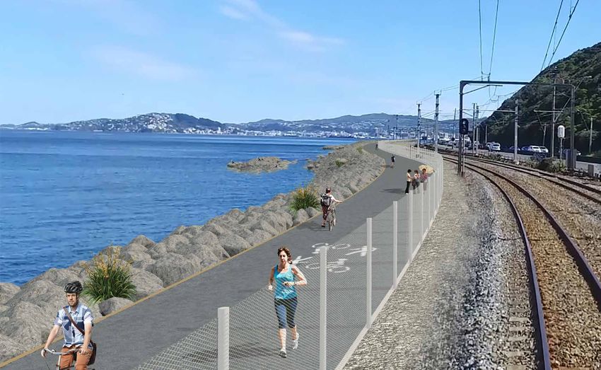
Wellington to Hutt Valley Walking and Cycling Link

  Partnering with
  Mana Whenua

  The Wellington to Hutt Valley walking                                                     CULTURAL EXPRESSION
  and cycling link project is partnering                                                    The overall concept for the path aims to celebrate the connections of mana whenua
                                                                                            to this place and of the mana and mauri of the harbour. The landings or ūranga provide
  with Wellington’s mana whenua – both                                                      the ‘canvas’ for this to happen, marking important sites and providing places to tell
                                                                                            stories and develop further design ideas such as:
  Taranaki Whānui ki te Upoko o te Ika                                                      • Naming of the path and possible logo
                                                                                            • N
                                                                                               aming of the bridge and each ūranga to share stories of ancestors, important
  and Ngāti Toa Rangatira – as we develop                                                     sites and tikanga
                                                                                            • C
                                                                                               ultural expression in the design – bridge, seating, paving, lighting, fencing,
  this project.                                                                               carvings, sculptures and artwork
                                                                                            • Artful signage and stories of place such as at Karanga Point
  We recognise the significance of Te Whanganui a Tara/Wellington Harbour
                                                                                            • Access and areas for Waka Ama spectators and recreation/fishing
  to both iwi groups, and we are working with them to ensure that the project
  honours the harbour, its environment and its history.                                     • K
                                                                                               aitiaki roles through design for birds and skinks and the shape and location
                                                                                              of the ūranga to enhance natural values.
  It is too soon to say exactly what will come out of our work together, but there
  are other examples from recent walking and cycling path projects that have
  incorporated Māori design and naming in partnership with mana whenua.
  We will also work with mana whenua as we develop the details of ecological                TARANAKI WHĀNUI DESIGN AROUND
  and landscape features and on other areas of common interest.                             TE WHANGANUI A TARA
                                                                                            ‘He Pātere mo te ara i tīmata mai Ngā Ūranga whakawhiti atu ra ki Pito One’
                                                                                            Kooe atu i te Korokoro o te ika
  WAHI PATAI CONCEPT                                                                        (Calling from the throat of the fish)
  – WELLINGTON CITY COUNCIL’S TAHITAI WALKING AND CYCLING PATH
                                                                                            Tīehuehu ana i Waihinahina
                                                                                            (Playfully splashing about at Waihinahina)
                                                                                            Rere kōkiri, kia whakaputa ki te ana ko Te Anaputa tērā
                                                                                            (Move forward to the exposing of the cave, at that place known as Te Anaputa)
                                                                                            Pikipiki maunga i Parororangi
                                                                                            (Then climb the summit at Parororangi)
TOHU A – PRECAST UNIT
                                                                                            Kōpere ki mua ki Tahataharoa
                                                                                            (Darting forward to Tahataharoa)
                                                                                            Whakanā te tinana i te urunga o nga waka
                                                                                            (Refreshing the body at the resting place of the canoes, Ngauranga)
                                                       PLACE NAMING TE AWA A TAIA CHANNEL

                                                                                            Na Kura Moeahu

  TAHITAI TOHU
                                                                                            Design Narrative
  Taranaki Whānui worked alongside landscape architects for the design of tohu signs to
  mark the pathway placed at sites with a story to tell about mana whenua connections       The purpose of the design elements/artworks
  – Te Awa a Taia is the name for the channel that separated Motu Kairangi (Miramar)        is to ensure that there has been consideration
  from the mainland prior to the earthquake, known as Haowhenua, in the 15th century.       of matauranga Māori (Māori knowledge)
                                                                                            and its relationship to Taranaki whanui,
                                                                                            Manawhenua and a connection to the
                                                                                            history of the local areas. These artworks
                                                                                            in time will become landmarks and the
                                                                                            aesthetic approach to infusing Māori
  TRANSPORT AGENCY PROJECTS IN OTHER PARTS OF AOTEAROA                                      into the project.
                                                                                            Shown here are potential sculpture concepts
  Te Wero Concept                             McClymonts Bridge                             created by Len Hetet
  – Mount Messenger Bypass Tunnel             – Northern Corridor Improvement

  State Highway 3, Taranaki,                  State Highway 1,
  artwork by PiriHira Takapua                 Albany, Auckland
  (TBC with Ngāti Tama)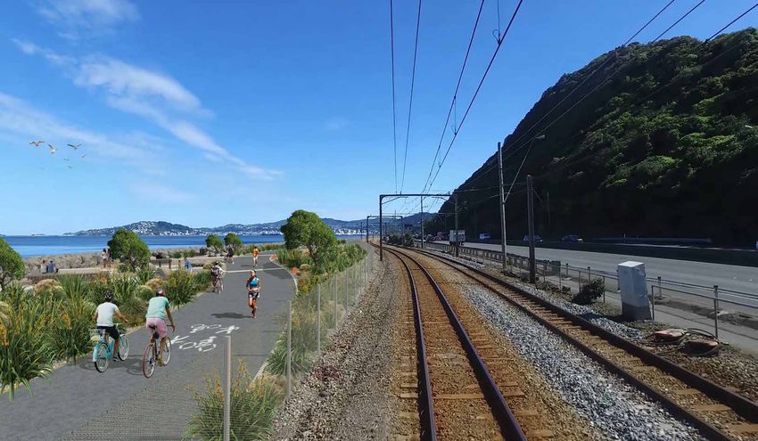
Wellington to Hutt Valley Walking and Cycling Link

     Ecology in the area
     Throughout this project we are keeping the natural
     environment and kaitiakitanga top of mind.
                                                                                                                                                                                  Separated
                                                                                                                                                                                  bird habitat

     This project is about more than a path. It presents us with an
     opportunity to create a new coastal environment along this heavily
     modified stretch of the harbour’s edge.
     We have already carried out ecological surveys both on the existing
     rocky shoreline, and underneath the water, which have highlighted
     areas of high biodiversity.
     These surveys found that birds, including gulls, kawau/shags and torea
     pango/variable oystercatcher use part of this coast during breeding
     season. Evidence of korora/little blue penguin burrows were also found.

     HIGH TIDE SEPARATED HABITAT
            1.8m mesh fence with                   5m Shared Path                                                               Below the water, species including blue cod, cushion stars, kina and mussels were found.
               integrated lighting
                                                              1m timber open palisade type                                      Any construction will have an effect on ecology in the area, but in our design for
                                                              fencing may be required in                                        landings along the path we have included places that will in future become new habitats
                                                              some areas to protect birds
Existing train tracks                                                                                                           for native wildlife. They will be planted with appropriate native coastal plants, and
                                                                     Coastal planting
                                                                                                                                potential bird nesting areas will be protected from disruption by people or dogs.

                                                                     Possible bird nesting sites

                                                                                                        Possible new habitat for skinks

                                                                                                                        Rocks sized for                High tide channel to
                                                                                                                        penguin nesting                separate bird habitat

                                                                                                                                                                                  High tide bird-roosting habitat

                                                                                                                                                                                                       Modified tidal and sub tidal
                                                                                                                                                                                                       habitat will establish over time

                                                                                                                                                                                                         MHWS (Mean High Water Springs)
                                                                                                                                                                                                                  MSL (Mean Sea Level)
                                                                                                                                                                                                                          MLWS (Mean Low
                                                                                                                                                                                                                            Water Springs)

         Pohuehue            Harakeke               Ngaio             Mokomoko                                   Korora               Kawau           Tarāpuka              Tōrea pango
   Muehlenbeckia complexa      Flax                               Northern grass skink                   Little blue penguins          Shag        Black-billed gull   Variable Oystercatcher
                                                                   Source: Department of Conservation

                                        SHOULD DOGS BE ALLOWED ON THE SHARED PATH?
                                        We are considering whether to recommend a dog-free area for the new shared path, or to recommend
                                        that all dogs must be on a lead.
                                        Right now, the harbour’s edge along the rail line is a habitat for birds, including penguins.
                                        The shared path will make it much easier for people to access the coastline, but this in turn will mean
                                        it would be easier for dogs to access the areas that birds may nest on the new rock wall.
                                        Birds, like native korora/little blue penguins, are very vulnerable when on land. They have no defence
                                         against a dog’s bite and carry a scent that can attract dogs’ attention. We could recommend that the
                                          area become a dog-free area, or that it become an area where all dogs must be on a lead.
                                                               We want your feedback on the best response to dogs on the path. Would you be
                                                               more or less likely to use this walking and cycling route if it is a dog-free area, or
                                                               if all dogs must be on a lead? What impact would this have on your opinion of
                                                              the project?
Wellington to Hutt Valley Walking and Cycling Link
Next steps for the Petone MELLING RAILWAY STATION
to Melling section
Existing shared path H
NORMANDALE
OVERBRIDGE
G
F
Shared path
Underpass connection
DOWSE INTERCHANGE
Cycle path E
We have received resource consent, Existing shared path Shared path
KOROKORO OVERBRIDGE
and funding has been approved to
D PETONE RAILWAY STATION
PETONE INTERCHANGE B
C
construct the Petone to Melling section of
A
Ngauranga to Petone section Underpass connection
the Wellington to Hutt Valley link. Construction
could begin as soon as later this year.
OPTIONS AT NORMANDALE ROAD
During community engagement in 2017, we asked people which of two options they preferred
to connect the Petone to Melling cycleway with the Hutt River Trail. Option A was underneath
the Normandale Road overbridge, while Option B was along Bridge Street. Option A was preferred
by 70% of people who chose an option.
People told us they preferred this option because it is safer and more scenic, and avoids cars,
driveways and pedestrians on Bridge Street.
Shared path approach to Normandale Road overbridge Shared path approach to Normandale Road overbridge
WHAT YOU TOLD US
We received 120 submissions from the public when we asked for
feedback on the Petone to Melling section, and 71% of them said they
think the Wellington Region will significantly benefit from the project.
‘It will make cycling between the Hutt and Wellington a convenient and
comfortable connection option that will ensure significant uptake. Resulting
in less pressure on our roads and public transport + healthier people!’
‘The completion of the full cycleway will be a wonderful asset for Wellington
and Hutt Valley residents alike in connecting us around our beautiful harbour. Petone Station Underpass with Kahikatea leaf design
For those of us who live in the Hutt Valley and work in the city the cycleway
and pedestrian options not only help us stay fitter and engage with our
surroundings but they also form an important part of getting home from
work in the event of a disaster.’
‘Many people would like to commute by bike but are afraid to. Being
separate from traffic will provide them with more options… The true
benefits will be attained when the whole section from Petone to the
CBD is separate from motorised traffic.’
‘More people will have the confidence to cycle, which will mean a healthier,
happier population, better environmental outcomes and less congestion.’
‘This is a great piece of infrastructure that is well over due. It offers
great connectivity for other cycling infrastructure and will allow
more people to access cycling in Wellington.’
‘Avoiding the Dowse interchange is great, but the full benefits
won’t be realised until the Petone interchange is sorted.’ Western Hutt Station Indicative artist’s impressionsWellington to Hutt Valley Walking and Cycling Link
Where to
from here?
Thank you for your interest and input on the Ngauranga
to Petone pathway project. Your feedback is a very
important part of this process and will help ensure
that any work we undertake on this project
reflects community aspirations. After this
engagement ends, we will report back
on how comments have influenced
the project. We are committed to
keeping this project progressing
strongly, and we will keep
you informed about
what’s happening.
HOW CAN I STAY UP TO DATE?
To keep up to date with this project you can sign up to our project newsletter, which will let you
know about upcoming events, the latest news and how the project is progressing. Email us on FILL IN OUR FEEDBACK FORM HERE
W2HVlink@nzta.govt.nz to receive our updates. TODAY OR ONLINE TO HAVE YOUR SAY
If you have questions, please get in touch with us by email on W2HVlink@nzta.govt.nz
TIMELINE:
MID 2019 – 2020 2020 – 2022
We will work on refining the We will apply for resource 2022 – 2025
MAY – JUNE 2019 design, considering feedback and consents for Ngauranga to
Provided resource consent
We are seeking public feedback technical advice. As part of this we Petone in early 2020. The consent
is granted, construction
on the proposed design for the will report back on how feedback has process may take up to two years.
of Ngauranga to Petone
Ngauranga to Petone section. been incorporated. Construction is The Petone to Melling section
section will take place.
expected to begin on the Petone is expected to be completed
to Melling section. during this period.
ACKNOWLEDGEMENTS:
We would like to acknowledge our funding partners:You can also read