Wipptal South Pilot Action Region: Gravity-Driven Natural Hazards and Forest Types
←
→
Page content transcription
If your browser does not render page correctly, please read the page content below
Chapter

Wipptal South Pilot Action Region:
Gravity-Driven Natural Hazards
and Forest Types
Christoph Hintner, Stefano Terzi and Stefan Steger

Abstract

    This chapter describes the Wipptal South Pilot Action Region (PAR) in South
Tyrol, where forests are well recognized to play a crucial role in protecting against
a variety of gravity-driven natural hazards, such as landslides, debris flows, rock
falls and snow avalanches. The chapter presents the three municipalities in the PAR
area in terms of socio-environmental context, gravity-driven natural hazards and
forest characteristics. The presented best-practice example describes the results of
a former project entitled “Waldtypisierung Südtirol” (Eng. Forest Characterization
South Tyrol) that focused on a detailed description of forests in South Tyrol and the
development of a handbook for foresters. It is shown that the Wipptal South PAR as
being is frequently affected by a variety of gravity-induced hazards while highlight-
ing the critical role of forest in protecting people and their properties. Appropriate
forest management strategies are vital to maintain and increase tree species diversity
(e.g. populating fir) and the associated protective forest function. In this context,
climate change effects, such as an increasing threat of bark beetle infestation due to
rising drought stress or the consequences of associated extreme weather events (e.g.
storms), pose major challenges for the local forests and their protective function.

Keywords: natural hazards, forest, South Tyrol, protective forest

1. Introduction

    The Wipptal South Pilot Action Region (PAR) represents one of the six study
sites of the Interreg Alpine Space project GreenRisk4Alps. The area lies in the center
of the Alps within the Autonomous Province of South Tyrol, northern Italy. The
areal extent of the PAR includes the three municipalities of Sterzing/Vipiteno,
Brenner/Brennero and Pfitsch/Val di Vizze (Figure 1a). Sterzing/Vipiteno is a
small city with around 7,000 inhabitants lying in the southern part of the PAR at
the valley bottom. The municipalities Brenner/Brennero and Pfitsch/Val di Vizze
exhibit a more distinct mountainous and rural character with a population of
around 2,300 and 3,100, respectively. The area was chosen as a pilot region for the
GreenRisk4Alps project for the following two reasons:

    • forest is well-known to play an important role in protecting against a variety of
      gravity-driven natural hazards

1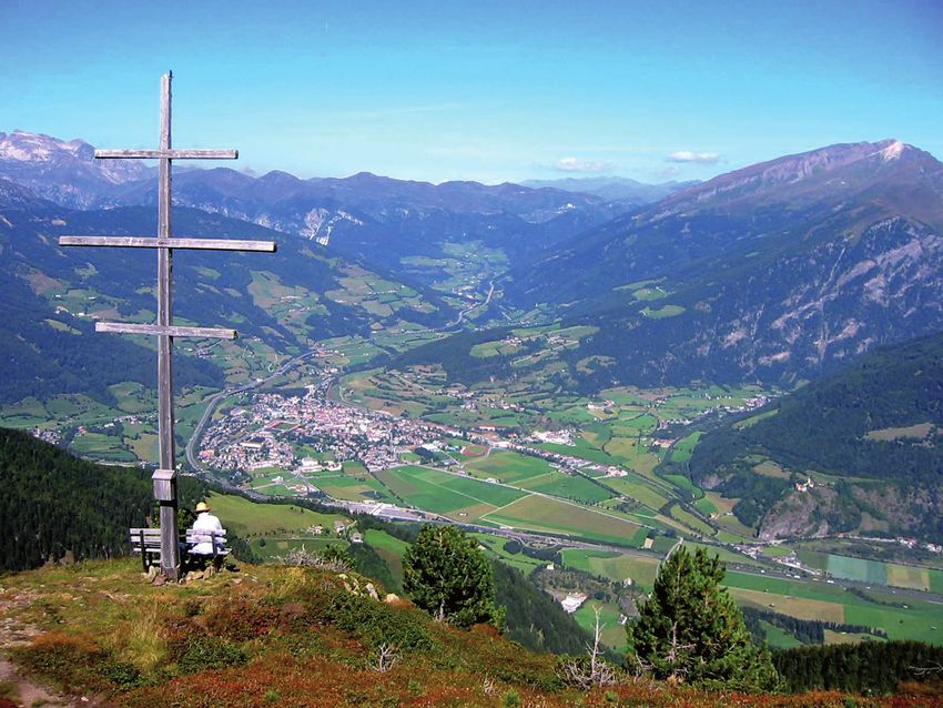
Best Practice Examples of Implementing Ecosystem-Based Natural Hazard Risk Management...

    • it directly borders the Austrian Vals/Gries PAR to the north, which allows
      the elaboration of cross-border similarities and differences in terms of forest
      management and its impact on the current natural hazard risk situation

   The present chapter first introduces the PAR and its three municipalities in
terms of socio-environmental context (Section 2) before highlighting the current
natural hazard situation (Section 3). These more general parts are followed by
the best-practice example (Section 4) that builds upon a former project entitled
“Waldtypisierung Südtirol” (here translated as “Forest characterization South
Tyrol”).
   This best-practice project focused on the characterization of forests in South
Tyrol and included a spatially explicit elaboration of forest typologies and associ-
ated ideal silvicultural treatment guidelines while also paying attention to the forest
protective function. The chapter is concluded by highlighting pending challenges in
terms of the protective forest and its management in the PAR (Section 5).

2. PAR description

2.1 General description

   The Wipptal South PAR is situated in the northern part of the Province of South
Tyrol with several mountain chains crossing the area. The area refers to the upper
Wipptal with the Brenner area to the north, the Pflersch Valley to the west, the
Sterzing Basin to the south and the Pfitsch Valley to the east (Figure 1b). The upper

Figure 1.
The location of the Wipptal south PAR within Italy and the areal extent of the three associated municipalities
(a). The 3D shaded relief image provides a visual impression of the morphology of the area (b). (data source:
GeoKatalog of the province of South Tyrol – http://geokatalog.buergernetz.bz.it/geokatalog/#!).

2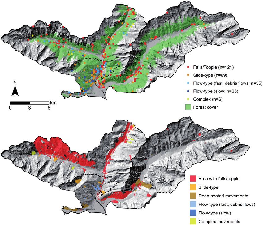
Wipptal South Pilot Action Region: Gravity-Driven Natural Hazards and Forest Types
DOI: http://dx.doi.org/10.5772/intechopen.99016

Wipptal is part of the Eisack Valley that borders with Austria at the Brenner Pass.
This mountain pass represents one of the most important strategic commercial
corridors in the Alps. The Pflersch and the Pfitsch valleys are located aside the main
transportation network, making them rather unspoiled and attractive for naturalis-
tic tourism, hiking and skiing sport activities (Figure 1b).
    In the Wipptal area, mountains span from the west, with the Stubaier Kalkberge
dividing the Tuxer Alps from the Pfitsch Valley, and run transversely from the
southwest to east of the Brenner line. South of the Pfitscher Joch (2,251 m), the
Pfunderer Mountains form the foothills of the Zillertal Alps, where the Hochfeiler,
at 3,510 m, represents the highest peak (Figure 1b). The area around the Hochfeiler
is heavily glaciated and merges into the more strongly dissected Pfunderer
Mountains, located in the high mountain region between the Pfitsch, Valser and
Pfunderer valleys.
    In summary, the mountainous environment characterizes considerable parts
of the PAR. The prevalent high altitudinal gradients and steep slopes are essential
controls for several gravity-driven processes that can rapidly displace a considerable
amount of material to the valley bottoms where most of the assets, urban areas and
villages are located (Figure 2).

2.2 Socio-environmental context

    The social, economic and environmental characteristics of the Wipptal South
PAR are fundamental in determining the risk associated with gravitational pro-
cesses. Each change in the socio-economic situation (e.g. changing population
densities at the foot slopes) or environmental conditions (e.g. climate change) can
modify the natural hazard risk situation. The comprehension of such differences
in the socio-environmental conditions across the PAR and their developments

Figure 2.
View of the main valley. Sterzing/Vipiteno as seen from the Elzenbaumer Wetterkreuz. (source: https://
it.wikipedia.org/wiki/Immagine:Sterzing-Vipiteno_and_Elzenbaumer_Wetterkreuz.JPG; author: Fantasy; CC
BY-SA 3.0: https://creativecommons.org/licenses/by-sa/3.0/legalcode; no changes were made).

3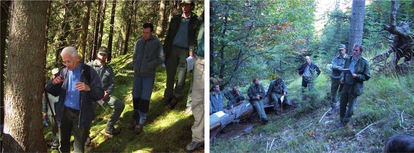
Best Practice Examples of Implementing Ecosystem-Based Natural Hazard Risk Management...

contribute to a better understanding of current and future impacts related to
gravity-driven natural hazard processes.

2.2.1 Population

    The entire Wipptal area represents the least populated district in the
Autonomous Province of South Tyrol. Five out of six municipalities and about 95%
of the area of the Wipptal can be classified as highly rural due to their comparably
low population density of less than 30 inhabitants per square kilometer [1]. The
area experienced an increase in population after 1960, a stagnation in the 1980s
and an increase again after the 1990s (this most recent increase being mainly in the
municipalities of Sterzing/Vipiteno and Pfitsch/Val di Vizze). In the other munici-
palities, a minimal growth rate or a decline in population have been recorded. The
city of Sterzing/Vipiteno has the largest population and, at the same time, the
smallest area, leading to a relatively high population density of 205 inhabitants per
square kilometer. Overall, the population density of the Wipptal South area is far
below the national average in all municipalities, except Sterzing/Vipiteno, underlin-
ing the rural character of the landscape [1].

2.2.2 Economy

    The geographical position of the PAR close to the border with Austria has always
supported trade activities between the south side of the Alps and Central Europe. In
this context, the Brenner Pass plays a strategic role as a corridor for the transporta-
tion of goods and for shaping the social and economic characteristics in the entire
province. While the vicinity of the pass affects the distribution of the population in
the valley bottoms, where facilities and means of transportation are located, it also
influences the type of existing economy, with most of the population employed in
services (66%), manufacturing (25%) and agriculture (9%) [1].
    In this sense, the municipalities of Brenner/Brennero and Vipiteno/Sterzing rep-
resent the economic hubs for the manufacturing and service sectors, with the latter
being the main urban area (6,979 inhabitants in December 2018, Provincial Statistics
Institute, 2019) and having an economic fabric focusing on Alpine technologies
(cable systems, snow groomers), and food products (milk-based products) [2].
    Tourism in South Tyrol represents a key sector, and the area has seen a steady
increase in visitation over the years. This is not only due to its geographical and
climatic conditions, but also to its historical and cultural background, which create
particularly favorable conditions for activities linked to tourism. In the Wipptal
area, Vipiteno/Sterzing and Brenner/Brennero have the highest bed occupancy
rates, while the rest of the area shows a declining rate, with potential for expanding
the tourist accommodation capacity [1].
    With respect to agriculture, the number of farms in the Wipptal has declined
at an above-average rate over the last 15 years. This is a clear sign that agriculture
in the Wipptal Valley is undergoing profound change. This has consequences for
the amount of land used for agricultural purposes and the ongoing process of rural
abandonment. However, in the municipality of Pfitsch/Val di Vizze, the utilized
agricultural area has increased, suggesting an intensification of agriculture activi-
ties with a lower number of farms [1].

2.2.3 Land use

   The city of Sterzing/Vipiteno, as the main town and district center, represents
only 11% of the area of Wipptal, at 33.2km2 [1]. The Wipptal has a below-average

4
Wipptal South Pilot Action Region: Gravity-Driven Natural Hazards and Forest Types
DOI: http://dx.doi.org/10.5772/intechopen.99016

proportion of artificial and agricultural land compared to the total area of the
province, with Sterzing/Vipiteno having the highest proportion of artificial
areas. In the context of rural communities, Pfitsch/Val di Vizze has a relatively
high proportion of agricultural land, which shapes its landscapes and economic
characteristics.
    Due to the high altitude of the area and the mountainous topography (Figure 1b),
however, all the municipalities in Wipptal South, except Sterzing/Vipiteno, have a
below average proportion of usable agricultural land compared to the Italian mean.
Such numbers, however, should be interpreted in the context of the considerable
amount of high-altitude areas and extent of high forest. In particular, the municipal-
ities of Pfitsch/Val di Vizze and Brenner/Brennero exhibit an above-average propor-
tion of high-altitude areas without vegetation [1]. The prevalent forest situation is
presented in detail in Section 4.

2.3 Climate

2.3.1 Past and current climate

    The Wipptal South PAR is characterized by a climate that is heavily influenced
by its alpine topography, with mountain peaks contributing to large diurnal
temperature variations. The general climatic condition can be described as temper-
ate with very cold and snowy winters and frequent cold winds coming from the
Brenner Pass. Summers are generally warm with maximum rainfall precipitation
and very intense localized events (Figure 3). The Köppen-Geiger climate clas-
sification is Dfb, meaning a warm-summer humid continental climate. The average
annual temperature in Sterzing/Vipiteno was 8.6°C for the period 2001–2010, while
cumulative annual rainfall was 699.1 mm over an average of 90 rainy days (data for
the period 2001–2010, Figure 3).
    The prevalent climatic characteristics, with frequent heavy precipitation events,
considerable snow fall in winter and snow melting in spring and frequent freeze–
thaw cycles at higher altitudes or in winter, generally favor suitable conditions for a
variety of gravitational natural hazards. The projected increase in temperatures due
to climate change is expected to affect the forest in the area as well as several hydro-
logical processes related to snow melting, runoff and soil infiltration. Moreover,
climate change is also affecting the number and frequency of extreme sudden
events (e.g. rainstorms and snowstorms), with acute consequences for environmen-
tal conditions and potential effects in terms of natural hazards. Three of the highest
daily values of precipitation, maximum and minimum temperature are reported in
Table 1, with extreme positive values of precipitation and temperature having been
recorded in the last 17 years, while minimum temperature values were recorded
further in the past.

2.3.2 Future climate

   Future changes in climate conditions are expected to affect forest development
and the occurrence of gravitational processes in the Wipptal South area. Although
climate projections are affected by a certain degree of uncertainty, they can also
provide indications of what can be expected in the future. In the context of the
GreenRisk4Alps project, climate scenarios for the PAR were derived from multiple
models and two greenhouse gas emission scenarios (Representative Concentration
Pathway, RCP): RCP4.5 (i.e. emission peak around 2040) and RCP8.5 (i.e. business-
as-usual scenario). Technical details on the derivation of climate change scenarios
are provided in Deliverable 1.1.1 of the project [3].

5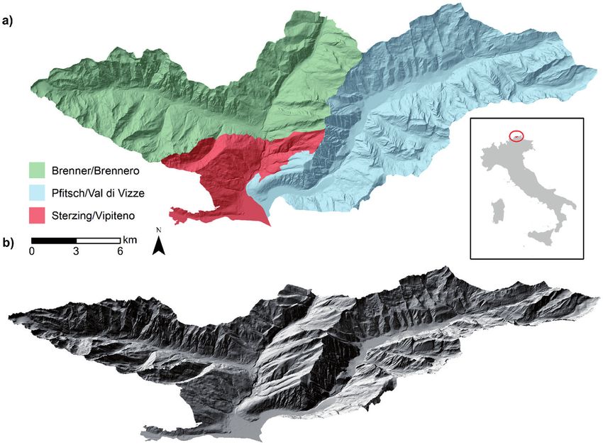
Best Practice Examples of Implementing Ecosystem-Based Natural Hazard Risk Management...

Figure 3.
Ten-year average monthly (x-axis) precipitation and temperature (y-axis) recorded at the weather station in
Sterzing/Vipiteno from 1931 to 2010 (data source: http://meteo.provincia.bz.it/download-dati.asp).

    Date              Precipitation           Date          Max. temp.           Date          Min. temp.
                         [mm]                                 [°C]                               [°C]

    2018-10-28             99.7            2013-08-03           35.5         2000-01-14           −20.6

    2012-08-05              81             2015-07-05           35.1          1999-12-22          −19.9

    2011-09-19             80.4            2003-08-13           34.7          1999-12-23          −19.8

Table 1.
Extreme daily precipitation and temperature values recorded at the weather station in Sterzing/Vipiteno.
Precipitation records are from 1/01/1981 onward, while temperature records are from 03/12/1998 onward (data
source: http://meteo.provincia.bz.it/download-dati.asp).

   The results for the Wipptal South PAR clearly depict a positive trend in tempera-
ture by all models, with considerable differences between the emission scenario
that foresees a peak around 2040 and the business-as-usual scenario (Table 2).
The more uncertain analysis of precipitation projections indicates slightly wetter

6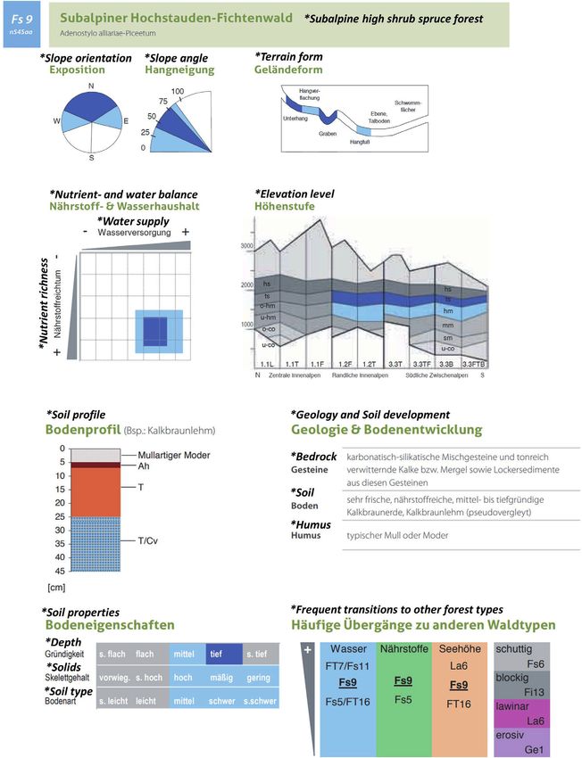
Wipptal South Pilot Action Region: Gravity-Driven Natural Hazards and Forest Types
DOI: http://dx.doi.org/10.5772/intechopen.99016

                                                              Wipptal South PAR

                                               RCP4.5                                   RCP8.5
    DJF                                          +1.7                                     +2.9

    MAM                                          +1.5                                     +2.9

    JJA                                          +2.2                                     +3.8

    SON                                          +2.0                                     +3.6

    Year                                         +1.8                                     +3.2

Table 2.
Trend in seasonal and annual mean temperature anomalies (reference 1971–2000) for the period 1950–2097.
The values are expressed as °C per century. Interpretation example (in bold): Annual mean temperature
variation over one century (e.g. 1951–2050) is +2°C (+1°C in 50 years). DJF: December, January, February,
MAM: March, April, may; JJA: June, July, august; SON: September, October, November.

conditions for future winters, with no clear trend regarding increasing or decreas-
ing precipitation amounts. The uncertainties involved call for a cautious interpreta-
tion of the results. Nevertheless, such outcomes are in line with existing studies on
climate change across Europe and Alpine regions (see e.g. [4–8]).
    In particular, the results on temperature highlight an increase in all seasons,
with a yearly average of +1.8 °C for the greenhouse gas emission peak in 2040
and + 3.2 °C for the business-as-usual scenario. Although the highest increase in
temperatures is expected during summers, the projected changes during
winters and springs should be carefully considered due to their potential
influence on snowfall and snow cover, frost conditions, run-off and soil
moisture.
    The models also depict seasonal changes for precipitation with generally higher
yearly precipitation in the business-as-usual emission scenario (Table 3).
    Changes in extreme precipitation conditions were also analyzed within the
GreenRisk4Alps project, and further details can be seen within Deliverable 1.1.1
[3]. In summary, the derived numbers indicate a statistically significant increase in
extreme precipitation for the business-as-usual emission scenario. In the case of an
emission peak around 2040, the derived extreme precipitation indicators showed
a lower signal and no statistical significance in most cases. Overall, the obtained
results need to be cautiously interpreted, especially in case of the analysis of total
precipitation and extremes (see e.g. [9, 10]).

                                                              Wipptal South PAR

                                               RCP4.5                                   RCP8.5
    DJF                                           +                                       +26.7

    MAM                                           +                                        +

    JJA                                           +                                       +15.2

    SON                                         +11.8                                      +

    Year                                         +8.1                                     +14.1

Table 3.
Trend in seasonal and annual total precipitation anomalies (reference 1971–2000) over the period 1950–2097.
The values are expressed as % per century. The trend sign (+ or -) is only reported for non-significant trends
(p-value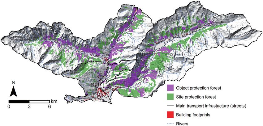
Best Practice Examples of Implementing Ecosystem-Based Natural Hazard Risk Management...

3. Natural hazard risks in the PAR

3.1 Principles of risk management

    The area is regularly affected by diverse natural hazard phenomena. After
severe weather periods in particular, rivers and streams can overflow their banks,
hillslopes can become unstable, debris flows or snow avalanches can occur and rock
walls and very steep terrain can produce rock falls. In South Tyrol, the Agency for
Civil Protection deals with protecting the population from the potential negative
effects of natural hazards. In summary, their integral approach to risk management
builds upon the combination of four pillars for the most efficient protection of
people and their belongings (cf. http://www.provincia.bz.it/sicherheit-zivilschutz/
wildbach/umgang-mit-naturgefahren.asp):

    • Prevention mainly focuses on spatial planning, including official hazard zona-
      tion, object protection (also via forests) and awareness raising.

    • Protection activities also include the case-specific design, construction and
      maintenance of technical protection structures.

    • Preparedness includes prediction, warning, emergency planning and the
      development of protocols in case of events.

    • Response and recovery activities relate to measures after an event, such as the
      implementation of protocols, restoring the pre-event state, redevelopment,
      learning from past events and improving conditions to cope with future events.

   These four risk management pillars should be considered as equally important,
and one pillar should not be neglected in favor of another. The official hazard
zonation of South Tyrol accounts for a variety of gravity-driven mass movement
hazards (slides and falls), water-related hazards and snow avalanches (Section 3.2).
For the Wipptal South PAR, these legally binding plans are currently in an advanced
stage of development (status: 4th December 2020): the municipalities of Brenner/
Brennero and Pfitsch/Val di Vizze are currently in phase C (technical examination),
while the plan for Sterzing/Vipiteno has recently been approved (http://www.
provinz.bz.it/natur-umwelt/natur-raum/planung/gefahrenzonenplan.asp).

3.2 Gravity-driven hazards

    The causes of gravity-driven hazards in the PAR are manifold and controlled
by a combination of diverse environmental factors. Besides the morphology of the
area, the properties of weathered slope material and hydrological and mechanical
effects of vegetation also influence the occurrence of natural hazards in the PAR.
Anthropogenic effects also play a role in modifying the natural risk situation. On
the one hand, humans frequently influence natural hazard processes due to e.g.
construction activities, slope undercutting or land use practices, while on the other
hand, construction and land use activities determine the exposure of assets. In the
PAR, gravity-driven hazards are mainly triggered by heavy precipitation events
and/or intensive snow melting (all mass movements), temperature alterations (e.g.
avalanches, rock falls), mid-term weather conditions (e.g. prolonged rain, wet or
snow-rich seasons) and direct human interference (e.g. construction works).
    Altitudes range from less than 950 m a.s.l. in the Sterzing/Vipiteno basin to more
than 3,500 m a.s.l. in the very east of the Pfitsch Valley (Hochfeiler in Figure 1).

8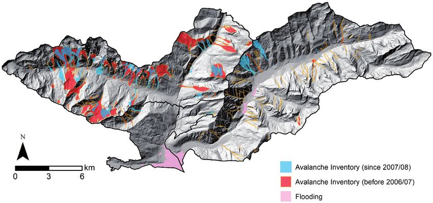
Wipptal South Pilot Action Region: Gravity-Driven Natural Hazards and Forest Types
DOI: http://dx.doi.org/10.5772/intechopen.99016

This considerable elevation difference entails substantial relief energy in the PAR.
In addition to altitude, slope aspect and associated shadowing effects co-determine
the prevalent temperature, insolation and precipitation regimes. In fact, mean
annual precipitation of around 700 mm can be observed for Sterzing/Vipiteno
(Figure 3), while rates of more than 1,000 mm/year are prevalent for some of the
mountainous areas (e.g. Pfitsch Valley).
    The geology and therefore also the subsurface material properties vary across the
PAR. In the Pflersch Valley, different kinds of gneisses and schists are prevalent, and
carbonate rocks, such as calcareous phyllites, marbles and dolomite (e.g. Pflerscher
Tribulaune), can also be found. In the Pfitsch Valley, the main rocks are landslide-prone
phyllitic mica-schists, paragneisses and granite gneiss. At the Brenner Pass, calcareous
phyllites and mica-schists are common. Glacial till, laid down directly by glaciers or
reworked by fluvial and other processes, covers large parts of the hillslopes [11].

3.3 Landslides of different movement types

    Natural hazard inventories provide an overview of the spatial distribution
of past events. In the basin area of Sterzing/Vipiteno, flooding and associated
hydrological processes are the main natural hazard. Figure 4 highlights that the
hilly and mountainous areas surrounding the area of Sterzing/Vipiteno are prone
to a variety of gravity-induced processes. Due to their mountainous character,
the municipalities of Brenner/Brennero and Pfitsch/Val di Vizze frequently

Figure 4.
Point and extension information for different landslides types. (data source: GeoKatalog of the Autonomous
Province of South Tyrol – http://geokatalog.buergernetz.bz.it/geokatalog/#!).

9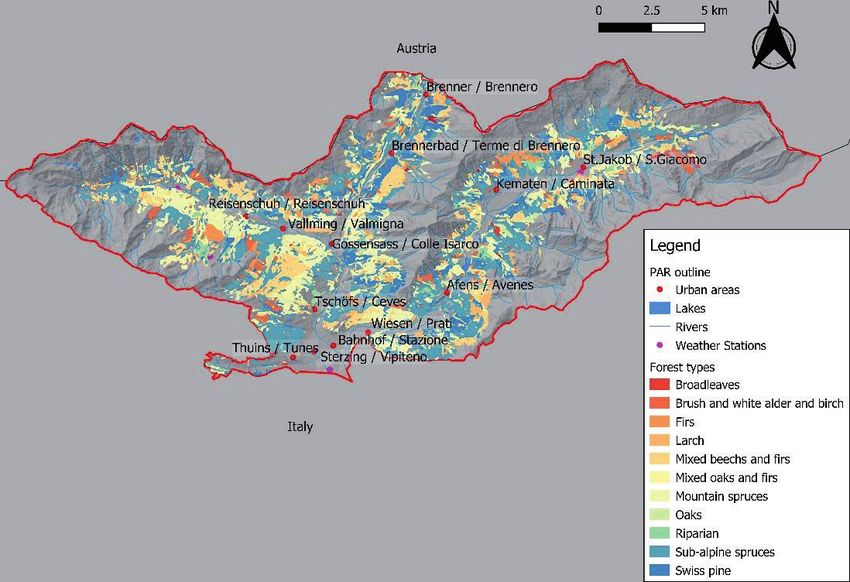
Best Practice Examples of Implementing Ecosystem-Based Natural Hazard Risk Management...

Figure 5.
Snow avalanche inventory of the area (light blue and red) and flooding area (light red). (data source:
GeoKatalog of the province of South Tyrol – http://geokatalog.buergernetz.bz.it/geokatalog/#!).

experience gravitational mass movements, such as landslides, rock falls, debris
flows and snow avalanches (Figures 4 and 5).
    The official Italian database for landslides (IFFI: Inventario dei Fenomeni
Franosi in Italia) provides an overview of registered past events. For the PAR, the
available point information depicts the initiation zones of different landslide types
(Figure 4). Even though this information was registered with high positional accu-
racy, it should be noted that it mainly portrays instabilities that caused damage or
induced an intervention by the local authorities. Thus, landslides that did not cause
damage or pose a risk were usually not registered [12]. For the PAR, 121 landslides
of the fall-type movement (mainly rock falls) and topples are registered. In particu-
lar, the south-exposed very steep parts of the Pflersch valley, the lower parts of the
Pfitsch Valley and the upper part of the Eisack valley are well-known to be prone to
rock fall processes. Landslides of the slide-type movement are characterized by a
downslope movement of earth and debris on a distinct (planar or rotational) sliding

Figure 6.
Buildings in the area affected by debris flows in 2012 (source: © Provinz Bozen Südtirol, Abteilung 30).

10
Wipptal South Pilot Action Region: Gravity-Driven Natural Hazards and Forest Types
DOI: http://dx.doi.org/10.5772/intechopen.99016
surface. A high portion of the 69 inventoried slide-type movements were registered
on the western lying hillslope in the municipality of Vipiteno/Sterzing. In total, 60
flow-type movements, which are mainly related to the prevalent channel system,
were registered. In this context, it should be emphasized that many hydrological
processes in the area, such as channelized debris flows, are not registered in the
IFFI dataset, but in an inventory called ED30 (not shown in the maps). Complex
movements consist of a combination of several movement types. Six of these
movements are inventoried for the PAR. A very interesting geomorphic feature in
the PAR is the impressive catastrophic rock-slope failure between the villages of
Afens and Ried in the Pfitsch Valley (cf. deep-seated movement in the Pfitsch valley;
Figure 4 bottom). The catastrophic slope collapse was dated with a minimum age of
11,290 ± 500 years before present and its masses cover around 0.9 km2. This massive
mass movement completely dammed the Pfitsch River, leading to the development
of a considerable backwater lake (11 km2). The lake area dried up after a devastating
outburst. The flat and wide valley floor upstream of this mass is a silent witness of
this impressive event and represents the former bottom of the lake [13].
3.3.1 Example of a severe debris flow event
The heavy weather event in August 2012 exemplarily highlights the potential
consequences of gravity-induced hazards in the PAR. On 4 August 2012, a series
of storms hit the Upper Isarco Valley, particularly the middle and lower part of the
Pfitsch Valley. On this day, cumulative precipitation values between 14 h00 and
22 h30 summed up to more than 80 mm in large parts of the area. Almost all of the
side streams suffered debris flows, and the Rio di Vizze River recorded significant
flooding that included a considerable amount of sediment. Damage to infrastruc-
ture was very serious, and the entire Pfitsch Valley remained isolated for a long
time. Unfortunately, two people lost their lives due to the debris flows. Figure 6
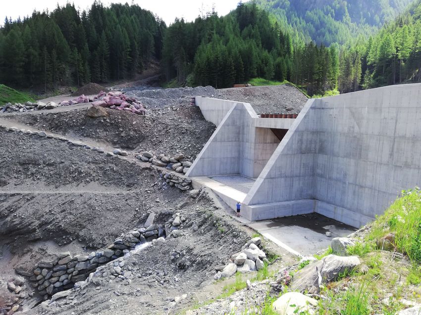
Figure 7.
Technical measure against debris flows upstream of the buildings in Figure 6. The site was visited during a
GreenRisk4Alps field trip in June, 2019 (source: © S. Cocuccioni).
11Best Practice Examples of Implementing Ecosystem-Based Natural Hazard Risk Management...
depicts the accumulation zone of one of the debris flows in the area. The restoration
works were carried out quickly and several technical mitigation works have been
finalized (Figure 7). Besides the events in the Pfitsch Valley, a major event (flooding
with extensive bedload transportation) was also registered at the Riesenbachl in
Sterzing, causing damage to infrastructure, buildings and vehicles.
3.4 Snow avalanches
The Agency for Civil Protection manages the snow avalanche inventory for
South Tyrol. Figure 5 highlights that snow avalanches are common on the hillslope
sides of the PAR. The threat posed by snow avalanches to infrastructure and build-
ings is considerably reduced in the PAR by a variety of protection measures. The
widespread forest on the lower lying hillsides provides crucial protection against
snow avalanches. For particularly prone areas or at high altitude sites, technical
measures such as snow bridges and avalanche nets are common.
4. The project “Forest Characterization South Tyrol”: best-practice
example for the Wipptal south PAR
The project “Waldtypisierung Südtirol” (further referred to as “Forest
Characterization South Tyrol”) represents the best-practice example for the PAR.
Within Section 4, we first present the aims and the background associated with this
project. Section 4.1 describes forest types at the level of the South Tyrol Province
and one example from the best-practice handbook. The different sections under
4.2 are also based on the abovementioned project but are dedicated to the Wipptal
South PAR. In this context, the forest type distributions (Section 4.2.1) and the
forest history and former management in the PAR (Section 4.2.2) are presented.
Section 4.3 highlights the protective forest in the PAR and related silvicultural
measures.
The results of this project are summarized in two freely accessible books
(Volume 1 and Volume 2 as pdfs in German or Italian) and can be downloaded
under the following link: http://www.provinz.bz.it/land-forstwirtschaft/wald-
holz-almen/studien-projekte/waldtypisierung-suedtirol.asp). The main aims of this
project were to:
i. determine the potential natural forest types in South Tyrol
ii. provide an ecological description of forest types in terms of location (terrain
forms and altitudinal levels), geology, soil, nutrient and water balance, and
vegetation
iii. provide a silvicultural characterization of forest types with regard to tree
species selection, forest management and forest regeneration methods
iv. summarize the results in a practice-oriented ecological handbook and
representation of the forest types on a map at a 1:25,000 scale with possible
indications for associated natural hazard processes
The objective of producing a scientifically sound and at the same time practi-
cable handbook required a thorough examination by all staff members involved in
the project. The developed silvicultural guidelines were intended to set a broader
framework for forest management within which sustainable actions are possible.
12Wipptal South Pilot Action Region: Gravity-Driven Natural Hazards and Forest Types
DOI: http://dx.doi.org/10.5772/intechopen.99016
The handbook was designed to provide foresters with a decision-making tool for
the selection of tree species and associated forest management practices. The main
target group of the handbook is therefore forestry personnel.
From a methodological viewpoint, stratification procedures were applied to
derive forest site units based on a comprehensive geo-ecological model. This model
integrates spatial information with the prevalent geology and associated substrates,
the morphology of the area (slope angle, aspect terrain forms) as well as climatic
information related to altitudinal belts. The forest site units were subsequently vali-
dated by means of detailed field surveys. To characterize the forest types in detail,
literature and the practical experience of local forest experts were also included
(Figure 8).
The aim of the associated workshops was to account for the local experiences of
foresters in silvicultural management and to consider their expertise when developing
the associated recommendations. Based on the selected forest sites, the current forest
management was discussed, and potential challenges were elaborated. During the
workshops, the developed handbook was first introduced in order to facilitate its later
use. The silvicultural discussion also led to the development of a common glossary.
When preparing the workshops, attention was paid to known silvicultural problem
areas. The selection of the locations for the workshops was then based on multiple
criteria, such as the representative forest type, homogeneousness and accessibility
of the site, and the forest function. During the workshops, previously collected and
prepared site and stand characteristics served the groups as a basis for their work.
The results of the individual groups were discussed together and then translated into
statements that were generally considered valid for the entire forest type. This allowed
the incorporation of local specificities and experiences into a practice-oriented
ecological handbook (see Section 4.1 for an example). The handbook was intended to
not only facilitate the silvicultural treatment of the individual forest types, but also
indicate their ecological importance and possible natural hazards.
4.1 Forest types in South Tyrol and handbook example
Half of the province of Bolzano/Bozen is covered by forests, for a total of
356,188 ha of forests. Due to this large forest area, management practices are
particularly important for supporting its many protective, productive, social and
ecological functions. In particular, 99% of the forested area is subject to hydrogeo-
logical provincial law restrictions [14] limiting and defining territorial and forest
interventions (e.g. deforestation, soil movements) that can negatively affect slope
stability and the water regime.
Figure 8.
Workshop participants develop silvicultural treatment strategies for many forest types (source: © C. Hintner).
13Best Practice Examples of Implementing Ecosystem-Based Natural Hazard Risk Management...
Most of the forest area in the province of Bolzano/Bozen is covered by sub-
alpine spruce (25.8%), followed by mountain spruce (19%), mixed beech and fir
(15.4%) and Swiss pine (13.1%), as reported in Figure 9.
The practice-oriented ecological handbooks first provide an overview of
the ecological classification for the forests of South Tyrol, which is based on the
regional climate, the predominant forest types and differences in altitudinal belts.
The different growth areas of South Tyrol are described in detail. The following
forest type catalog characterizes the prevalent forests based on both ecological and
silvicultural aspects. The results of the silvicultural and site analysis, the outcome
of interviews in forest stations and discussions during workshops were incorpo-
rated into the description of each individual forest type. In addition to the forest
type map in Figure 9, forest types can also be determined by means of a forest type
key. This key has a logical structure, whereby the forest type is mainly determined
by three input variables: site group, altitudinal gradient and substrate group.
For example, the comprehensive forest type catalog contains several sub-catego-
ries and among them a category called “subalpine spruce forests”. This subcategory
in turn contains a detailed elaboration of eleven individual forest types, such as
“subalpine high shrub spruce forest” (Adenostylo alliariae-Piceetum). Each specific
forest type is presented concisely (two pages) using easily comprehensible text and
graphs (Figure 10).
For instance, such a forest is predominantly present on north-exposed slopes,
on rather steep terrain (> 40°) and at altitudes above ~1,500 m.a.s.l. The general
appearance of this type is then described in a short text block. The geology and soil
development are shown and describe that this forest type predominantly develops
over carbonate–silicate mixed rocks and clay-rich weathering limestones or marls
as well as on loose sediments from these rocks with nutrient-rich, medium- to
deep-textured calcareous brown soil or calcareous brown loam. The following sec-
tion entitled silvicultural evaluation highlights accompanying forest types, forest
productivity, formation and forest development. Furthermore, the specific forest
Figure 9.
Areal extent of forest type distributions and percentage of total forested area in South Tyrol (provincial forest
type classification, data source: GeoKatalog of the province of South Tyrol – http://geokatalog.buergernetz.
bz.it/geokatalog/#!).
14Wipptal South Pilot Action Region: Gravity-Driven Natural Hazards and Forest Types DOI: http://dx.doi.org/10.5772/intechopen.99016 Figure 10. Example of the representation of one specific forest type (Adenostylo alliariae-Piceetum) from the original handbook (volume 1). For this figure, the main categories were translated into English (marked with *). For details refer to the text below. functions are also highlighted and show that this forest is usually a “commercial forest with protective functions, especially against landslides, floods, snow movement and rockfall.” The last text block focuses on recommendations for its silvicultural treatment and provides recommendations for natural regeneration and forest management. It should be noted that this example should only provide insight into the extent of detail included for the many identified individual forest types that are presented in the handbook. 15
Best Practice Examples of Implementing Ecosystem-Based Natural Hazard Risk Management...

4.2 Forest characterization for the PAR

4.2.1 Forest type distributions

    The Wipptal South PAR area is characterized by extensive forested areas, most
of which are sub-alpine and mountain spruce forests. Larch forests in montane
and sub-alpine locations extend over large areas from Gossensass/Colle Isarco
via Sterzing/Vipiteno to the southern slopes around Mauls/Campo di Trens, in
the Pfitsch Valley to Kematen/Caminata as well as from Gossensass to Hinterstein
(Figure 11). The distribution coincides well with the extent of the calcareous shales
on which these forest types were anthropogenically created due to their suitability
for grazing and mowing (larch meadows). On the other hand, natural juniper-larch
forests are covered with numerous dry plants on sunny steep slopes above limestone
slates. Larch also dominates the dwarf-shrub-rich stands in high sub-alpine and
steep and shady areas together with mountain pine. In the lower, high-montane
level (up to 1,300 m), a steppe heath pine forest grows on steep sunny sides at a sim-
ilar location, and an earth sedge pine forest grows on the marble stock near Mauls/
Campo di Trens. While in the Sterzing/Vipiteno basin, there are also dry grassland
and shrubs with sedge bushes, and in the rest of the area, larch and spruce forests
are mostly widespread. In the Pflersch Valley, pine forest stretches from the bottom
(1,230 m) to the orographic limit at 1,600 m above sea level, with pine receding in
favor of spruce as the valley narrows. Swiss stone pine only appears locally in the
inner Pfitsch above Stein and on the N-S ridges north of Zinseler and Hühnerspiel.
This is partly due to the Swiss stone pine fault area above limestone slate, and partly
to clearing activity and the use of alpine pastures in subalpine areas.

Figure 11.
Wipptal south PAR area and location in South Tyrol with a visualization of the main forest types according
to the European environmental agency (EEA) forest categories and types, weather stations, urban areas, lakes
and rivers. (data source: GeoKatalog of the province of South Tyrol – http://geokatalog.buergernetz.bz.it/
geokatalog/#!).

16
Wipptal South Pilot Action Region: Gravity-Driven Natural Hazards and Forest Types
DOI: http://dx.doi.org/10.5772/intechopen.99016
Compared to the whole province of Bozlano/Bozen, the Wipptal South PAR is
characterized by a lower percentage of Swiss pine forests, which account for 3.1%
of the PAR forest area. Moreover, some particular species do not occur in the PAR,
such as beech, Orno-ostryenion and spruce-fir-beech mixed forest. While mountain
spruces are still widespread, the share of mixed beech and fir forest is lower (8.7%)
than in the whole province (15.4%). Nevertheless, the share of larch woods and
brush and white alder and birch is larger (8.1% and 8%, respectively) compared to
that in the whole province (2.5%) (Figures 12 and 13).
Figure 12.
Areal extent of forest type distributions and percentage of total forested area in the Wipptal south PAR
according to the data presented in Figure 11 (provincial forest type classification, data source: GeoKatalog of
the province of South Tyrol – http://geokatalog.buergernetz.bz.it/geokatalog/#!).
Figure 13.
Areal extent of forest type distribution and percentage of total forested area in the PAR (EU forest type
classification, data source: GeoKatalog of the province of South Tyrol – http://geokatalog.buergernetz.bz.it/
geokatalog/#!).
17Best Practice Examples of Implementing Ecosystem-Based Natural Hazard Risk Management...
The soil in the area is formed over carbonate-rich rocks (mica marble, calcareous
slates, green rocks) to calcareous brown soils with a much more demanding ground
vegetation of nutrient-indicating herbs and tall perennials. At such sites, larch has
been establishing itself as the predominant tree species. With the exception of a
few individual finds, no fir trees occur due to the climatic conditions. Green alder
bushes cover slopes and ditches on the shady side, more common in the Brenner
area and the inner Pfitscher Valley. Deciduous forests with predominant ash, gray
alder (occasional sycamore maple) are limited to sliding ladders on the lower slopes.
The Eisack and Pfitscher streams are partly covered with gray alder floodplains.
On the Pfitscher Bach near St. Jakob, there is also an occurrence of lavender willow
meadows with German tamarisk.
4.2.2 Forest history and former management in the PAR
In the Middle Ages, considerable mining activities took place in the Sterzing/
Vipiteno area, formerly the largest mining area in Tyrol. However, the altitude, lack
of wood and water were a hindrance, and mining activity was soon abandoned. The
Gossensasser Bergordnung of 1427 specifically mentioned the use of forests for the
extraction of coal. Although wood burning was strictly prohibited, forests were not
protected by these regulations. Many other directives were issued in 1460, 1502 and
1511 in an attempt to regulate the felling of wood for sale, coal burning, cutting and
construction timber, although the effect of the laws was little to no forest protection
[15, 16]. New regulations in 1527 tried to limit pitch and resin extraction, which was
particularly damaging to forests, and smelters were strictly forbidden to cut green wood
while there was still a drought. It was generally stipulated that only old trees could be
cut down with limitations on the cutting of forests to be converted into pastures [17].
During times of need in the 19th century, the forests in Pfitsch/Val di Vizze were
once again severely decimated, and from 1847, when “forest purification” took place
(forest was returned by the state to the communities), a period of uncontrolled use fol-
lowed throughout the Wipptal. Frequently, “plundering forests” were created through
the use of the strongest trunk with a subsequent cattle drive. From 1875 to 1877, the
drainage of the Sterzing/Vipiteno area and the Wiesner part of the moss was carried
out, with the remaining riparian forests being converted to cultivated land [18–20].
Livestock breeding and pasture farming also had an impact on the forest.
Wooden fences were erected to limit the forest and alpine pastures. The pasture
areas were often extended with cattle driven into cut clearings with the forest
reduced to create pre-alpine and alpine pastures. In 1515 and 1527, for example, the
Sterzing forestry administration opposed the conversion of clear cuttings into per-
manent pastures [21]. In many cases, forest grazing rights are no longer exercised
today [22]. Similarly, the large mountain meadows in Pfitsch (e.g. “in der Schnagge”
and on the “Birchmahdern”) have not been mown for some time [23]. In Pfitsch,
where the proportion of private forests is very high, the timber industry has always
had some importance as a source of income, and the proportion of farms owning
forest and selling timber is above the average for the Wipptal. Although there were
occasional sales of timber to other countries, most of it was processed for local use,
as the supply of timber from the Pfitscher Hochtal was very difficult before the
construction of the road [20, 24]. The forest of the Pflersch Valley is predominantly
in the hands of interested parties [22, 25].
4.3 Protective forest in the PAR and related silvicultural measures
Forests are well-known to influence several types of these hazard types, and
available data on object protective forest indicates that forests play a paramount
18Wipptal South Pilot Action Region: Gravity-Driven Natural Hazards and Forest Types
DOI: http://dx.doi.org/10.5772/intechopen.99016
role in protecting people and assets, such as settlements and infrastructure. The
prevalent site protective forests also provide protection to nature and different
ecosystems (e.g. soils, plants). The spatial designation of protective forest indica-
tion areas (Figure 14) is based on the community Initiative Interreg III Austria-Italy
2000–2006. These maps provide a general overview of where the current forest in
the PAR protects people, settlements and infrastructure (object protective forests)
or the ecosystem (soils, plants, site protective forests) against rock falls, snow
avalanches and debris flows.
A large part of the forest in the area (around 50%) in the PAR can be considered
as protective forest, with 19% object protective forest and 31% site protective forest
(Figures 14 and 15). This comparably high number is not surprising considering
that gravitational hazards are common in the area and forests are mainly located
on hillsides (Figure 4a). Table 4 highlights the share of site and object protective
forest for each municipality of the area in detail.
The main focus in the silvicultural management of protective forests is to
maintain their protective function. According to the South Tyrolean Forest Act
[26], every tree must be identified by the forest authority before felling. During the
timber display, the foresters come into contact with the forest owners and can thus
also give them silvicultural advice. In this way, the protective forest function can
optimally be taken into account in the management procedures. In order to main-
tain the protective effect, the forest has to be managed in a continuous, near-natural
way. If a protective forest is not used for a longer period, the forest may no longer
fulfill its protective function.
Many forested areas in the Wipptal, especially in the communities of Brenner/
Brennero and Pfitsch/Val di Vizze, fulfill an essential protective function against
snow movements and avalanches. In such forests, management aims to ensure that
the forests do not become over-aged and that regeneration approaches are present
over the entire area. If logging is carried out, no extensive use should be made in the
fall line. At slope gradients of greater ~70%, the gap length in the fall line should be
less than 50 m to prevent the onset of forest avalanches.
The situation is similar for rockfall protective forests. Here, similarly, the gap
length in the stand has a great influence on the protective effect, since falling stones
Figure 14.
Protective forest map for the Wipptal south PAR according to the south Tyrolean protective forest indication
map (data source: GeoKatalog of the province of South Tyrol – http://geokatalog.buergernetz.bz.it/
geokatalog/#!).
19Best Practice Examples of Implementing Ecosystem-Based Natural Hazard Risk Management...
Figure 15.
Protective forest type distribution in Wipptal south according to the south Tyrolean protective forest indication
map. Note that the class “other” was derived as the difference between the total forested area and the protective
forest types, i.e. object and site (data source: GeoKatalog of the province of South Tyrol – http://geokatalog.
buergernetz.bz.it/geokatalog/#!)
Municipality Site protective forest Object protective forest
Brenner/Brennero 66% 32%
Sterzing/Vipiteno 43% 10%
Pfitsch/Val di Vizze 74% 26%
Table 4.
Proportion of site and object protective forest by municipality.
may reach their maximum speed after only 40 m of track length. During timber
display, care is taken to avoid large uses in the fall line.
In both rockfall protective forests and avalanche protective forests, slash-like
uses across or diagonally to the fall line are considered particularly suitable. It is
important to ensure that the slit-like openings are not too wide so as not to diminish
the protective forest function.
Stand maintenance is of great importance in protective forests. In order for
the trees to achieve good individual stability, they must not grow up too densely.
Young growth with a large number of trunks must therefore be vigorously thinned
already in the thickening stage. In order to stabilize pole woods and to improve the
structure, the formation of rotations is recommended in the protective forests of the
subalpine altitudinal zone.
5. Conclusion and some challenges
The chapter highlighted the critical role of protective forest in the natural
hazard prone PAR. In this context, future challenges are expected as a consequence
of climate change. It is assumed that the prevalent spruce tree species might become
more prone to bark beetle infestation due to increasing drought stress. Therefore, it
is particularly important to focus on tree species diversity to ensure a future protec-
tive function. The fir tree species in the Wipptal, for instance, is of great relevance
20Wipptal South Pilot Action Region: Gravity-Driven Natural Hazards and Forest Types
DOI: http://dx.doi.org/10.5772/intechopen.99016
in this context. Investigations in the area have shown that the potential of fir is high
on many sites and particularly on shady hillslopes. Currently, however, fir trees are
often absent because of the former extensive use of wood. From a forest manage-
ment perspective, red deer populations also restrict the successful natural regenera-
tion of fir. If fir is to be promoted in the Wipptal Valley in the future, the red deer
population must be controlled.
The current low timber price, as a result of damaged due to the recent storm
events, also has an unfavorable effect on the protective forest in the PAR. As a
result, there is currently no incentive for forest owners to carry out small-scale
harvesting in protective forests. It is expected that if the price of wood does not
rise in the near future, more measures and subsidies from the public sector will be
required to maintain the functioning of the protective forest.
Acknowledgements
We thank the province of South Tyrol for providing data and photographs.
Author details
Christoph Hintner1, Stefano Terzi2,3 and Stefan Steger3*
1 Forest Inspectorate Sterzing/Vipiteno (Forstinspektorat Sterzing/Ispettorato
forestale Vipiteno), Sterzing/Vipiteno, Italy
2 United Nations University Institute for Environment and Human Security
(UNU-EHS), Bonn, Germany
3 Institute for Earth Observation, Eurac Research, Bozen/Bolzano, Italy
*Address all correspondence to: stefan.steger@eurac.edu
© 2021 The Author(s). Licensee IntechOpen. Distributed under the terms of the Creative
Commons Attribution - NonCommercial 4.0 License (https://creativecommons.org/
licenses/by-nc/4.0/), which permits use, distribution and reproduction for
non-commercial purposes, provided the original is properly cited.
21Best Practice Examples of Implementing Ecosystem-Based Natural Hazard Risk Management...
References
[1] Entwicklungsplan L. LAG Wipptal precipitation and wind extremes over
2020 Lokaler Entwicklungsplan. Europe in an ensemble of regional
2020;(1305). climate simulations. Tellus, Ser A Dyn
Meteorol Oceanogr. 2011;63(1):41-55.
[2] IDM Südtirol - Alto Adige. South
Tyrol - The Economy. 2013;40. [10] Rajczak J, Schär C. Projections of
Future Precipitation Extremes Over
[3] Steger S, Teich M, Crespi A, Europe: A Multimodel Assessment of
Kindermann G, Jandl R, Hormes A, et Climate Simulations. J Geophys Res
al. Green Risk 4 Alps - Deliverable WP Atmos. 2017;122(20):10,773-10,800.
T1 PRONA. 2020.
[11] Stingl V, Mair V. Einführung in die
[4] Brönnimann S, Rajczak J, Fischer E, Geologie Südtirols:[aus Anlass des 32.
Raible C, Rohrer M, Schär C. Changing Internationalen Geologischen
seasonality of moderate and extreme Kongresses im Sommer 2004 in
precipitation events in the Alps. Nat Florenz]. Autonome Provinz Bozen-
Hazards Earth Syst Sci. Südtirol, Amt f. Geologie u.
2018;18(7):2047-2056. Baustoffprüfung; 2005.
[5] IPCC. Climate Change 2014: Impacts, [12] Steger S, Mair V, Kofler C, Pittore M,
Adaptation, and Vulnerability. Part A: Zebisch M, Schneiderbauer S. A
Global and Sectoral Aspects. statistical exploratory analysis of
Contribution of Working Group II to the inventoried slide-type movements for
Fifth Assessment Report of the South Tyrol (Italy). In: Guzzetti F,
Intergovernmental Panel on Climate Mihalić Arbanas S, Reichenbach P,
Change. 2014. Sassa K, Bobrowsky PT, Takara K,
editors. Understanding and Reducing
[6] Isotta FA, Frei C, Weilguni V, Perčec Landslide Disaster Risk, Volume 2 From
Tadić M, Lassègues P, Rudolf B, et al. Mapping to Hazard and Risk Zonation.
The climate of daily precipitation in the Springer Nature Switzerland AG; 2021.
Alps: Development and analysis of a
high-resolution grid dataset from [13] Ostermann M, Sanders D. The
pan-Alpine rain-gauge data. Int J Benner pass rock avalanche cluster
Climatol. 2014;34(5):1657-1675. suggests a close relation between
long-term slope deformation (DSGSDs
[7] Schmidli J, Goodess CM, Frei C, and translational rock slides) and
Haylock MR, Hundecha Y, Ribalaygua J, catastrophic failure. Geomorphology.
et al. Statistical and dynamical 2017;289:44-59.
downscaling of precipitation: An
evaluation and comparison of scenarios [14] Il bosco altoatesino in cifre | Bosco,
for the European Alps. J Geophys Res legno, malghe | Amministrazione
Atmos. 2007;112(4):1-20. provinciale | Provincia autonoma di
Bolzano - Alto Adige [Internet]. [cited
[8] Schmidli J, Frei C. Trends of heavy 2021 Feb 22]. Available from: http://
precipitation and wet and dry spells in www.provincia.bz.it/agricoltura-
Switzerland during the 20th century. Int foreste/bosco-legno-malghe/bosco-in-
J Climatol. 2005;25(6):753-771. alto-adige/
il-bosco-altoatesino-in-cifre.asp
[9] Nikulin G, Kjellström E, Hansson U,
Strandberg G, Ullerstig A. Evaluation [15] Kofler H. Heimatbuch Gossensass
and future projections of temperature, und Pflersch mit den Weilern
22Wipptal South Pilot Action Region: Gravity-Driven Natural Hazards and Forest Types DOI: http://dx.doi.org/10.5772/intechopen.99016 Giggelberg und Pontigl. Band 1; Häuser- und Höfegeschichte. Hg.: Marktgemeinde Brenner. 2004. [16] Oberrauch H. Tirols Wald und Waidwerk, ein Beitrag zur Forstund Jagdgeschichte. 1952. 328 p. [17] Mutschlechner G. Hochwälder, Schwarzwälder, Bannwälder. 1981. [18] Stern R. Der Waldrückgang im Wipptal. Mitteilungen der Forstlichen Bundesversuchsanstalt in Wien; 70. Heft; Österreichischer Agrarverlag. Wien; 1966. [19] Trenkwalder A. Beiträge zur Geschichte des Pfitschtales. 1978. [20] Gemeinde Pfitsch. Gemeindebuch Wiesen Pfitsch. 1998. [21] Wopfner H. Bergbauernbuch. Von der Arbeit und Leben des Tiroler Bergbauern in Vergangenheit und Gegenwart. Hg.: Nikolaus Grass. Wirtschaftliches Leben. Band 3. Innsbruck: Universitätsverlag Wagner; 1997. 722 p. [22] Ennemoser G. Gossensass - Beiträge zur Geschichte der Gemeinde Gossensass mit besonderer Berücksichtigung der Zeit von 1850- 1914. Universität Innsbruck; 1975. [23] Wieser J, Trenkwalder A, Staindl L. Wiesen-Pfitsch. Südtiroler Gebietsführer. Bozen: Athesia; 1981. [24] Fröhlich H. Die Einkommensverhältnisse der Landwirte im Wipptal. Beiträge zur alpenländischen Wirtschafts- und Sozialforschung. Innsbruck; 1968. [25] Ennemoser G. Gossensass – Brenner –Pflersch. Südtiroler Gebietsführer. 1984. 39 p. [26] Provincia autonoma di Bolzano Alto Adige. Legge provinciale 21 ottobre 1996 n. 21. 1996. 23
You can also read