WITH STEVE LANORE, CBM MAY 28, 2020 - MAY 2020: WIND AND HAIL CRASH THE PARTY, TORNADOES ALMOST A NO-SHOW
←
→
Page content transcription
If your browser does not render page correctly, please read the page content below
With Steve LaNore, CBM
                                   May 28, 2020

May 2020: Wind and Hail Crash the Party, Tornadoes Almost a No-Show
It was a rather strange spring month over much of the “lower 48”, that is, all of the states excluding Alaska and
Hawaii. There were bouts of record cold. We tracked huge windstorms that traveled hundreds of miles. The
Storm Prediction Center (SPC) logged far fewer tornadoes than average. Ironically, despite the low tornado
count, claims for May 2020 property losses are in the billions thanks to several “Level 5” hail events in
populated areas - Level 5 is the highest ranking available so that’s the big stuff! And of course there was the
May 3rd “Derecho” event that we’ll get to. A crazy big one.

                                    NOAA: April tornado averages by state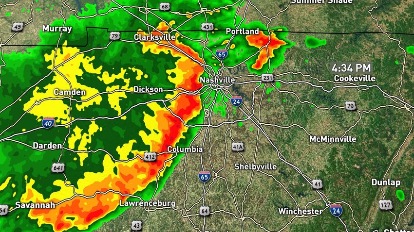
Meanwhile May, which is typically the heart of severe weather season came in at about 1/3 of normal:

                               “Quiet” in May: about
                               100 tornadoes versus
                               an average of 257: just
                               39% of normal!

          A very busy April

               NOAA tornado counts YTD through May 25: a big surge in April, “crickets” in May

                                   NOAA: May tornado averages by state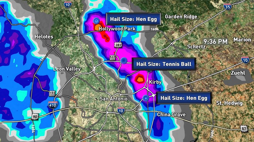
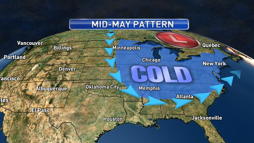
So, what drove away the Tornadoes in May?
We talked about this somewhat in last month’s newsletter: unseasonably cool weather invading the eastern
half of the United States in the early to middle part of May. Cool weather and tornadoes really don’t mix as
Supercell thunderstorms, the ones that make big tornadoes, thrive on warm-moist air along with wind shear.
But a huge dip in the jet stream pushed the remnants of winter’s arctic air far to the south:

A few “big chill” statistics from this cold wave:

All-time May record lows set on May 9:

Binghamton, New York 24 degrees

Indianapolis 27 degrees

JFK Airport (New York City) 34 degrees

And London, Kentucky (28 degrees), tied their all-time May records Saturday morning.

Nashville, Tennessee, found frost on the ground with a coat-friendly 35-degrees.

But it didn’t stop there. The tornado-killing cold extended well into the southern U.S. on May 10:

Richmond, Virginia 32 degrees;

Shreveport, Louisiana 47 degrees; and

Wilmington, North Carolina 41 degrees

Even high temperatures struggled to get folks out of their jackets and sweaters. The cold wave continued on
May 12, where Cape Girardeau, Missouri managed a high of only 54 degrees, their chilliest late-season high in
almost 40 years. Brrr!
But, there were a few intense outbreaks of wind and hail that dodged the “cold sandwich” in mid-May.
May 2-3 Derecho
A large complex of thunderstorms took shape over southern Kansas on the night of May 2 and a combination
of favorable steering winds and plenty of warm moist air (this is before the cold wave struck a few days later)
allowed this large cluster of severe storms to track all of the way across southern Missouri into Kentucky,
Tennessee and Alabama, racking up lots of damage along the way.
“Derecho” comes from a Spanish word for “straight”, as in wind blowing in one direction and not like a
tornado. It was a fierce event with winds of 60 to 80 mph along the path from southern Missouri and all the
way to the hardest hit high-population center, Nashville. It seems Tennessee’s capital city can’t get a break as
it is still recovering from the horrific March tornadoes only to get hammered with winds just short of hurricane
force, 71 mph, on May 3. Of course that’s at the airport and higher winds may have gusted elsewhere in town.
This system brought down thousands of trees along its path and hundreds in Nashville, knocking out power to
130,000 citizens (an all-time high) and causing widespread damage. Typical loss claims across the city included
trees on homes, roof damage, vehicle damage and wind damage to outbuildings.
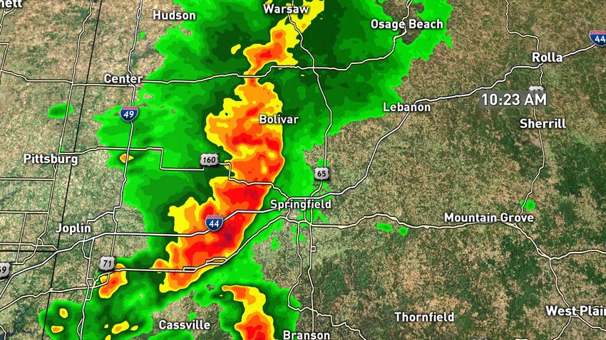
Check out these two radar timestamps, at 10:20 a.m. the Derecho was dumping hail on Springfield, MO; six
hours later it had rocketed all the way to Nashville, about 400 hundred miles downstream:
May 3: Derecho slams through southern Missouri in the morning….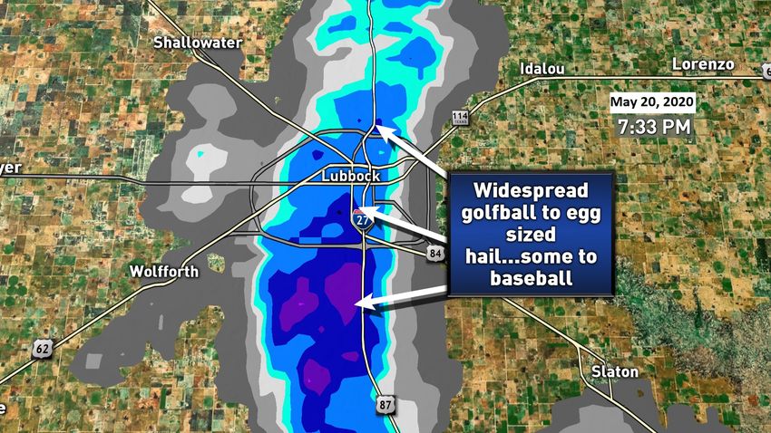
And makes it all of the way to Nashville just six hours later. NWS data.

Once the mid-month cold spell passed, violent weather returned this time to Texas and Florida. The Lone Star
State took three severe poundings from hailstorms: Lubbock on the evening of May 20 where at least 40% of
the city received hail of quarter size or greater, and a significant percentage of that golfball size or larger
(severe damage threshold). Hail estimator programs suggest that 30,000 structures received at least quarter
sized hail with 5,000 to 10,000 getting ping pong ball or larger stones, and certainly thousands of vehicles as
well.
Just 25 hours later, San Angelo took it on the chin with another destructive hail swath of egg to tennis ball size
pelting this city of 100,000. As bad as these two storms came to be, the most far-reaching one (and most
expensive) is likely to be the severe San Antonio thunderstorms of May 27. The “Alamo City” took a direct hit
from a hail core tracking more than 20 miles across the metro area. The hail size and population density along
the track suggest this storm will outdo Lubbock and San Angelo in total property loss, but it’s too early to say
for sure.

       May 27, 2020: San Antonio hailstorm paths, the most intense of the two labeled here. NWS data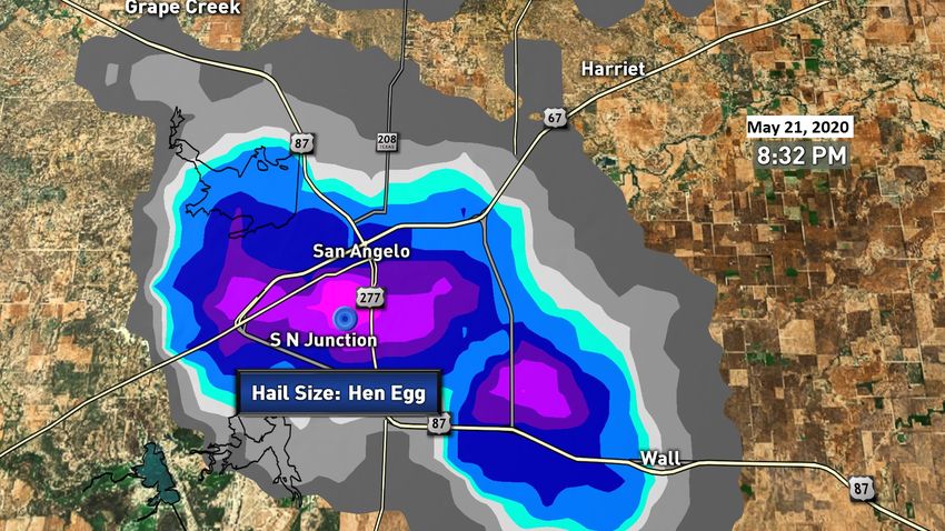
Also ran: a May 21 central Florida hailstorm came nowhere close to the Texas versions, but it still affected
5,000 residences with quarter-size or larger hail.

       Areas northeast of Orlando and west of Daytona Beach got some big hail on May 21. NWS data.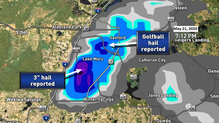
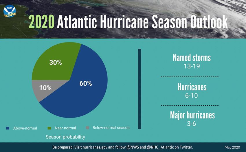
Hurricane Onslaught Expected
Colorado State’s Tropical Meteorology Project season outlook was featured last month, it predicted above-
normal hurricane activity; NOAA’s official outlook for the season released May 21 calls for a similar robust
season with three to six MAJOR hurricanes, that’s Category 3 or higher:

The pie chart (above) paints an ominous picture with twice the likelihood of an above-average season
compared to a near normal season, and six times as likely as a below-average season. We’ve already seen two
named storms in May, quite uncommon; neither amounted to much with the most recent, “Bertha” limping
ashore in North Carolina with very little effect.

But what’s for sure - they won’t all be that way. Of course the “rub” is that no one can accurately forecast
where one will hit and at what intensity more than a few days out. And by the way a lucky guess that gets it
right is not a forecast based on skill, if it can’t be reproduced by other scientists then it’s not much good for
the next time.

Fires and Floods
The majority of the United States east of the Rockies is in a drought-free condition with the exception of
Florida and parts of Texas. The primary wildfire concerns are the usual suspects: California, Colorado/New
Mexico and Oregon. The outlook for California is for a warm and dry summer so despite conditions in most of
the state “not that bad” right now, we could easily see another tough time by July and August. The unique
thing about California weather is even after a rainy winter the nature of the vegetation can change from wet
to fire-prone in just a couple of months if it’s just a bit hot. The other problem – winds blowing down from the
mountains get very dry, at times down to 5 percent relative humidity, so high dry winds can quickly dry out
vegetation in just a matter of a week or two. This can happen in any mountainous area, it just happens more
often in California.

                                       From droughtmonitor.unl.edu

             A very high chance of above-average temperatures in California this summer / NCEP
Adjuster Hot-Spots:
Severe storms: With the upper ridge (shown in this newsletter) pushing the jet stream northward, expect the
most concentrated severe weather to be in southern Canada, and across northern Plains eastward to New
England. So we’re talking from Minneapolis and Chicago east to New York and Massachusetts. This is a typical
pattern as we get into summer.

Coastline: June is not a big hurricane month, but we already saw two smaller storms in May and a June storm
will be of higher than average probability.

Fires: Pretty early for fire season, but the extreme drought pockets bear watching as things warm up quickly.
Everglades fires in Florida are also a threat.

Earthquake: Always a threat in the western U.S., it’s been a while since we’ve seen one on some of the major
faults in California, something to consider.

Here’s wishing you a pleasant and COVID-free month!

Take Care,

Steve LaNore, CBM
You can also read